Report
ON THE ASCENT TO THE SUMMIT "VMF" VIA THE EASTERN RIDGE, CATEGORY 2B
BY THE TEAM OF ALPCLUB "POLITECHNIK" "POLITECH-4" FROM AUGUST 4, 2022 TO AUGUST 4, 2022
I. Ascent Passport
| № п.п. | 1. General Information | |
|---|---|---|
| 1.1 | Full Name, Sports Rank of the Leader | Gerus Denis Anatolyevich, 1st sports rank |
| 1.2 | Full Name, Sports Rank of the Participants | Latyshenko Kondrat Olegovich, 3rd rank; Smirnova Alena Vitalyevna, 3rd rank; Fominykh Mikhail Sergeyevich, 3rd rank |
| 1.3 | Full Name of the Coach | Molodozhen Vladimir Alyaksandrovich, Olennikov Sergey Alyaksandrovich |
| 1.4 | Organization | FA SPb a/c "Polytechnic" |
| 2. Characteristics of the Ascent Object | ||
| 2.1 | Region | Central Caucasus |
| 2.2 | Valley | Adyrsu, from the Chiperezau pass to the Gumachi summit (Baksan, Adylsu, Shkhelda, Kyrtik valleys) |
| 2.3 | Section Number according to the Classification Table of 2013 | 29 |
| 2.4 | Name and Height of the Summit | 3745 |
| 2.5 | Geographical Coordinates of the Summit (Latitude/Longitude), GPS Coordinates | 43.24471, 42.75438 |
| 3. Characteristics of the Route | ||
| 3.1 | Name of the Route | Via the Eastern Ridge |
| 3.2 | Proposed Category of Complexity | 2B |
| 3.3 | Degree of Exploration of the Route | Variant |
| 3.4 | Nature of the Relief | Combined |
| Route | ||
| :--: | :--: | :--: |
| 3.5 | Height Difference of the Route (data from altimeter or GPS) | 600 m |
| 3.6 | Length of the Route (in meters) | 1600–1850 m |
| 3.7 | Technical Elements of the Route (total length of sections with different categories of complexity, indicating the nature of the relief (ice-snow, rocky)) | I cat. complexity rocks — 200–250 m. II cat. complexity rocks — 350–400 m. III cat. complexity (combination) — 150–200 m. Rappelling (on descent) — 3 ropes, 150 m |
| 3.8 | Descent from the Summit | Via the ascent route |
| 3.9 | Additional Characteristics of the Route | To confirm the passage of category 2B, it is necessary to remove the note in the control tour on the rocks of the ridge |
| 4. Characteristics of the Team's Actions | ||
| 4.1 | Time of Movement (team's working hours, in hours and days) | Ascent 6 hours — Descent 4 hours |
| 4.2 | Overnight Stays | Start and finish at the Jalovchat overnight stays |
| 4.3 | Departure for the Route | 04:00 August 4, 2022 |
| 4.4 | Arrival at the Summit | 10:00 August 4, 2022 |
| 4.5 | Return to the Overnight Stays | 14:00 August 4, 2022 |
| 5. Responsible for the Report | ||
| 5.1 | Full Name, e-mail | Fominykh Mikhail Sergeyevich, m.s.fominyh@gmail.com |
II. Description of the Ascent
1. Characteristics of the Ascent Object
The summit VMF (Peak of the Navy) is located at the end of the Northern spur of the Main Caucasian Range, dividing the Adylsu and Adyrsu valleys, in a lateral spur from the Uzlovaya summit. The first ascent was made in 1939 by A. Zyuzin via the Western ridge. According to the "Classification of Routes to Mountain Summits" of the Alpine Federation of Russia, 2013 edition, two training routes are laid out on the VMF summit:
- Category 1B complexity
- Category 2B complexity
The entire area of the Jalovchat glacier is characterized by strongly rugged relief.
2. Characteristics of the Route
From the AUSB "Ullutau" down the road to the "Jailyk" base. Then across the bridge to the left orographic bank of the Adyrsu river and along the trail along the supports of the suspension road — along the left moraine. At the top, cross the stream to the right moraine. Along the right moraine, ascend in the direction of the rocky outcrop between the moraines of the Jalovchat glacier and the Northern Koyavgan glacier. Traverse up to the right onto the talus under the rocky outcrop. Ascend along the talus to the lake. "Jalovchatskie" overnight stays by the lake. Initial bivouac. From AUSB "Ullutau" 3–4 hours.
Geographical coordinates of the overnight stays GPS 43.234864, 42.765802.
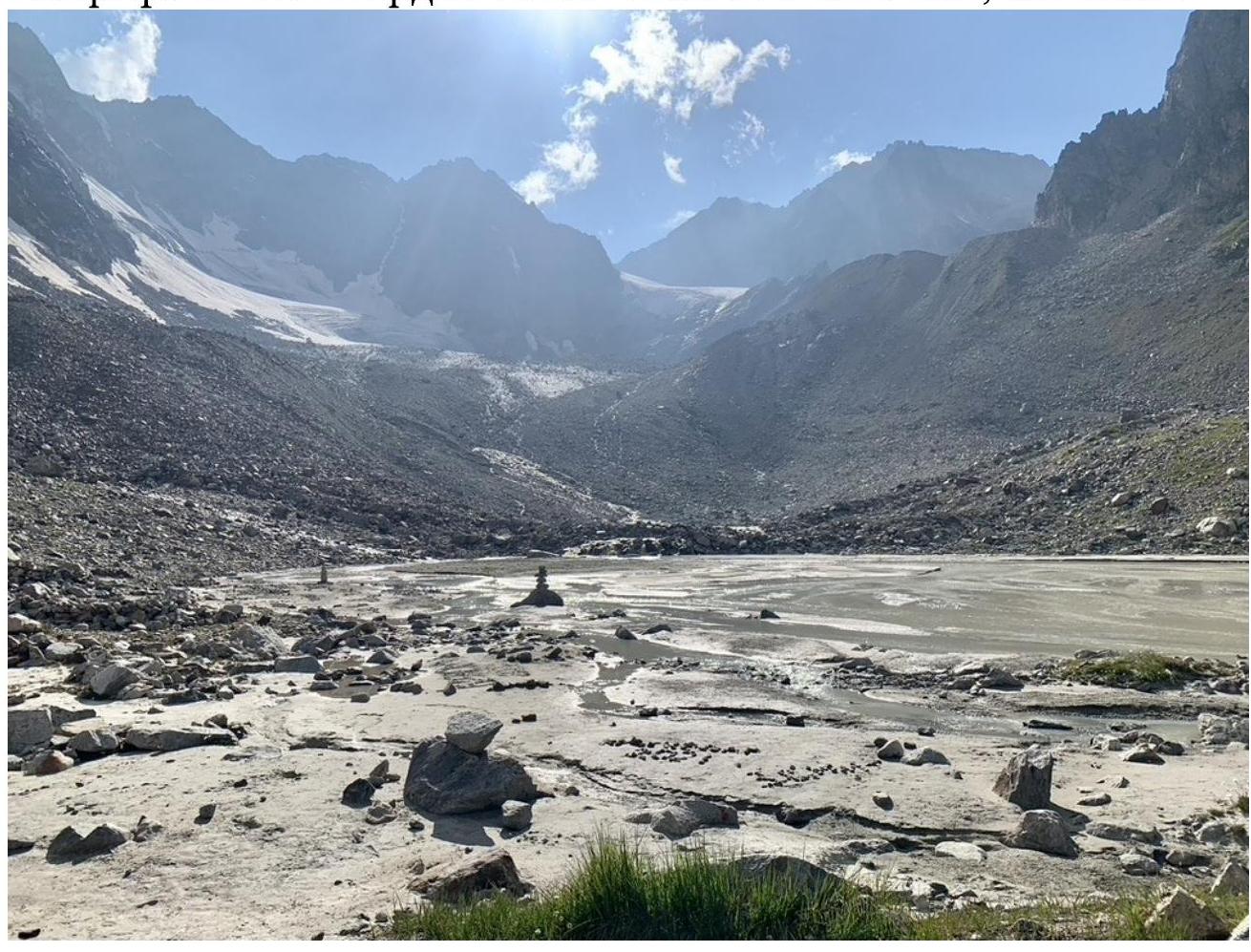 View
from the "Jalovchat overnight stays" to p. Den - Fizkulturnik, Jalovchat glacier, to the right is visible the rocky ridge hiding p. VMF, behind it — the lake (August 3, 2022)
View
from the "Jalovchat overnight stays" to p. Den - Fizkulturnik, Jalovchat glacier, to the right is visible the rocky ridge hiding p. VMF, behind it — the lake (August 3, 2022)
R0–R1. 800–1000 m, 10–15°.
From the initial bivouac, cross the stream flowing out of the lake and further, leaving the pronounced rocky ridge (towers of the Southern counterfort) to the left, along the large-stone moraine, reach the lake, geographical coordinates of the lake GPS 43.240763, 42.760578.
From the lake:
- approach the clearly pronounced large couloir descending from the Eastern ridge, to the left of the gendarme;
- the couloir is located slightly above the lake.
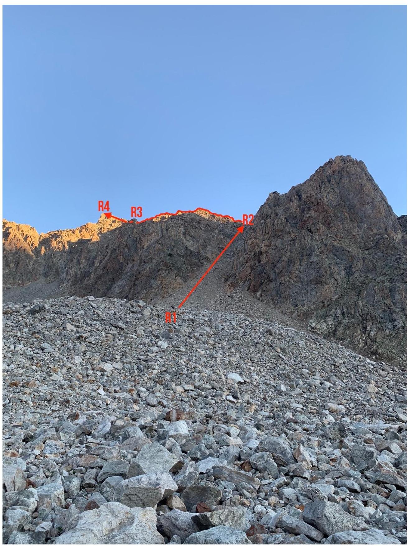
General view of the route, ascending couloir, to the right gendarme, view from the lake
R1–R2. 200–250 m, 20–25°, I. Up the couloir, exit to the wide snow-rock saddle of the Eastern ridge. From the overnight stays 2–2.5 hours.
R2–R3. 350–400 m, 30–40°, II.
From the saddle, to the left along the destroyed simple ridge in the direction of the gendarme Uzlovaya (located at the junction of the Eastern and Western ridges).
On the rocks of the ridge, a control tour.
The gendarme is bypassed to the right.
After the gendarme, exit to a wide, rocky saddle under the summit tower.
Overnight stays are possible.
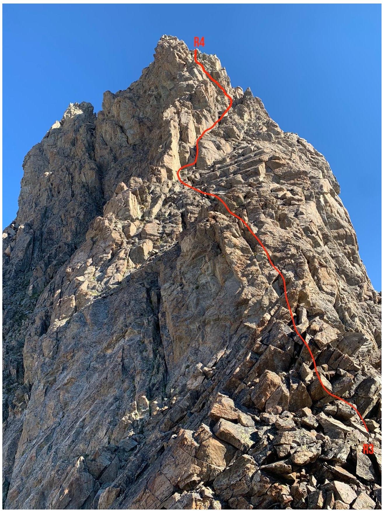
R3–R4. 150–200 m, 65–70°, II–III.
From the saddle, ascend to the summit tower in its left part, with an exit to a narrow ridge.
Along the narrow, steep ridge (key point) — exit to the summit. At this section:
- there are rappel rings,
- the first station is made of a channel and a hook,
- it is possible to organize insurance after checking the reliability of the stations and rings.
A two-meter wall is overcome head-on.
The ascent along the summit tower takes about 1.5 hours. From the initial bivouac — 4–5 hours.
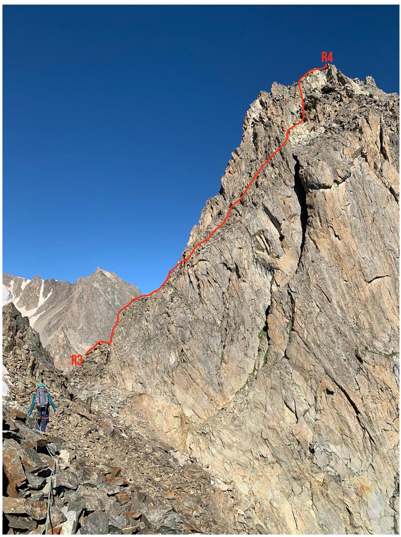
Key section R3–R4 — ascent to the summit tower
General view of section R3–R4 "en face", summit tower
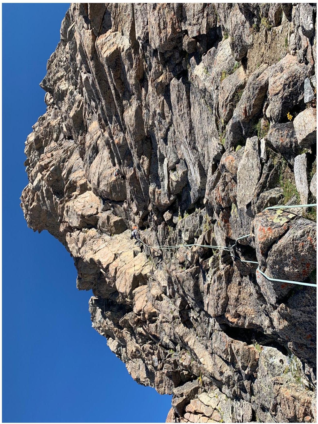
Work on section R3–R4
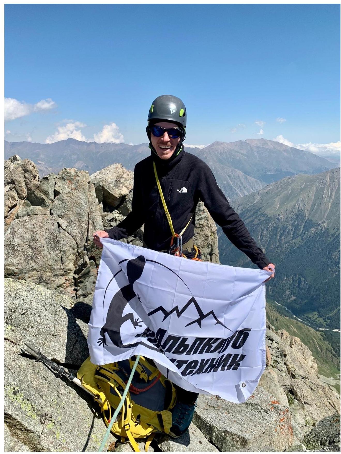
At the summit of p. VMF (August 4, 2022)
Descent along the ascent route, from the summit tower it is more convenient to rappel, there are rings, 3 ropes, 150 m. Descent 2–3 hours.
2.3. Technical Characteristics of the Route Sections
| Section № | Nature of Relief | Category of Complexity | Length, m | Type and Number of Pitons |
|---|---|---|---|---|
| R0–R1 | Large-caliber moraine, talus | 800–1000 m | ||
| R1–R2 | Talus couloir | I | 200–250 m | |
| R2–R3 | Destroyed rocky ridge | II | 350–400 m | |
| R3–R4 | Simple destroyed rocks, narrow rocky ridge | II–III | 150–200 m | Set of large-sized nuts, large friends |
3. Characteristics of the Team's Actions
The route is undeservedly neglected by climbers from AUSB Ullutau. Our team removed the summit note from last year (judging by the information, the previous team removed the note from 2020).
The approach is complicated psychologically: first, you have to go down, and then — a long, not steep and constant ascent up, with a steep climb at the end. The reward for the exhausting approach will be the picturesque and, most importantly, deserted "Jalovchatskie overnight stays". There are equipped places for parking, drinking water from a stream flowing in from the left of the "lake".
Conditions in 2022:
- The year turned out to be warm and sunny
- The glacier stood high
- The lake dried up
The approach to the route is short and pleasant, before the exit directly to the route, there is an opportunity to admire the pre-dawn turquoise towering lake.
The couloir is talus, unpleasant rather on descent:
- at first, you can safely go along the center;
- at the top, it is better to stick to the right or left edge.
In the 2022 season, there was no snow on the saddle and the rockfall danger was minimal.
The ridge is simple, insurance is provided by the relief.
Uzlovaya gendarme before the summit tower:
- is bypassed to the right along the couloir;
- or is overcome head-on.
The saddle before the summit tower is wide and comfortable even for overnight stays.
The summit tower itself is a simple destroyed rock, with an exit to a narrow ridge. Insurance is provided on stationary stations (there are first and second — channels, hooks, and rings), then on own points, there are enough large-sized nuts and a couple or three friends.
To the summit, overcome a narrow rocky ridge, insurance is provided through ledges.
In good weather, a magnificent panoramic view. Descent from the tower by rappelling (there are rings), some duplicated with their own, then climbing and along the ascent route.
Talus descent in the couloir:
- movement in a group
- without gaps
In general, the route is quite safe, pleasant, and picturesque. Can be recommended for fulfilling the norms of the 3rd sports rank.
When preparing the report, materials from the training department of AUSB Ullutau and the Adyrsu valley were used. Part I. Routes of alpine training ascents. — M.: PRESTO-RK, 2007. — 96 p. Porokhnya Yu.I., Zaitsev K.K., Terentyev V.V.,
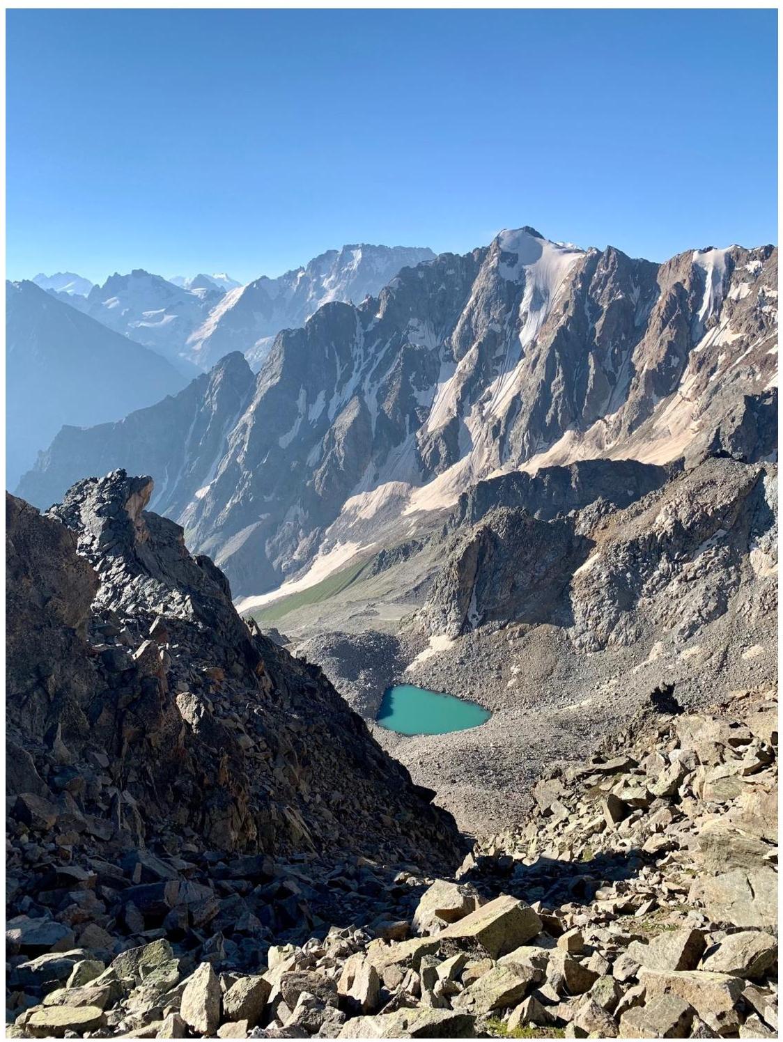
View of the mountain lake from the saddle at the beginning of the route (immediately after exiting the couloir)