II Asport
-
Rock climbing category.
-
Central Caucasus.
-
Bashkara peak, 4241 m, via the North Face.
-
Proposed category of difficulty – 5B, rated.
-
Route characteristics:
height difference including the icefall 600 m, length of sections with 5th category of difficulty 510 m, avg. slope 65°, 6th category of difficulty 80 m, avg. slope 85°, average slope of the wall section of the route 60.5°
-
Pitons driven:
rock 53, bolt 7/7, ice 15, chock stones 91/4
-
Total climbing time 17.5 hours
-
One overnight stop on the ridge, comfortable.
-
Team leader Zakharov V.G., Candidate for Master of Sports
participants: Ponomarev V.V., Candidate for Master of Sports Arkhipov V.A., Candidate for Master of Sports Bakaleinikov E.D., Candidate for Master of Sports
- Kuznetsov A.V., 1st sports category
- Pereverzev E.P., Candidate for Master of Sports
-
Coach Bayakin S.G., Master of Sports.
-
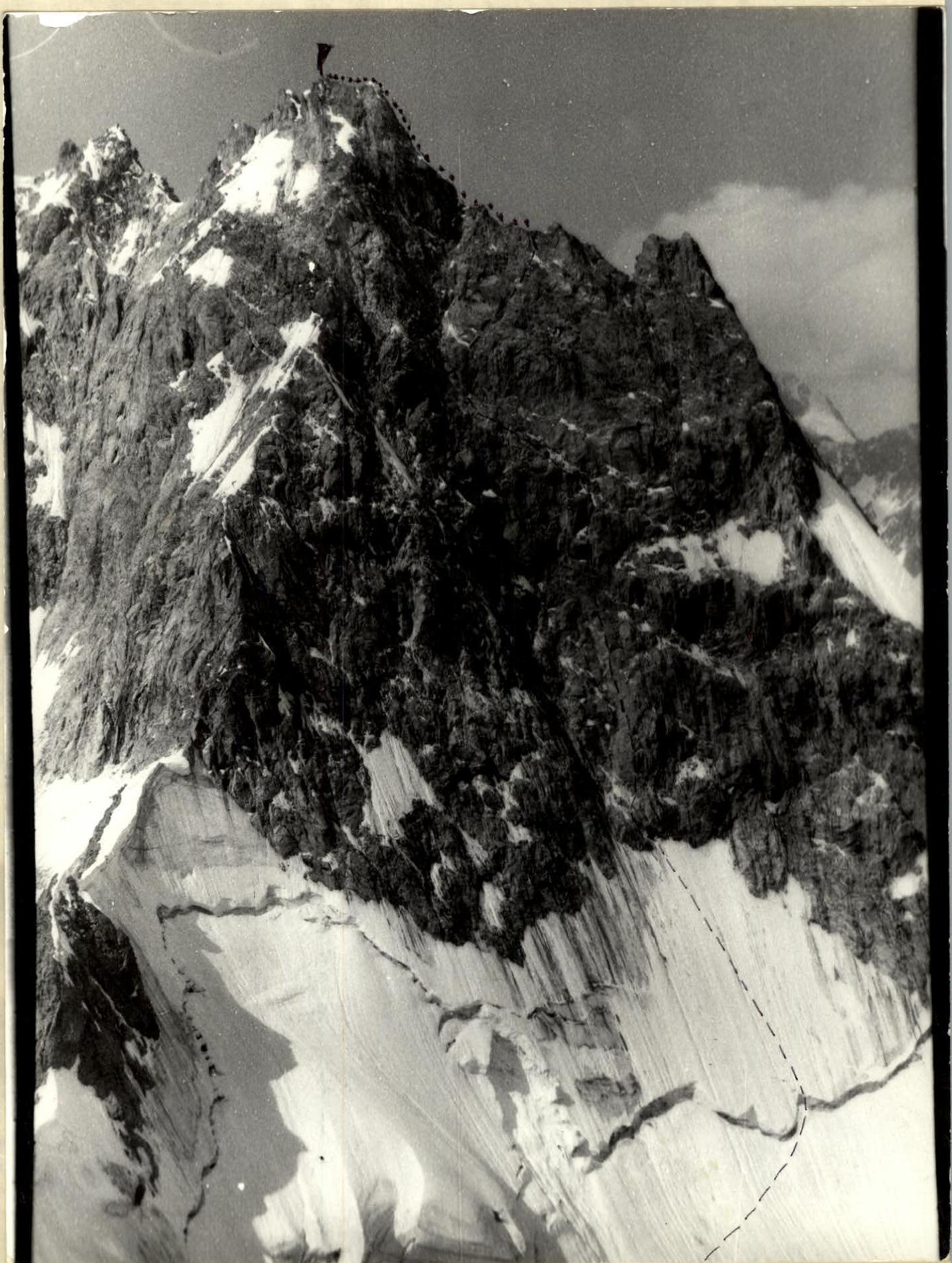
Approach to the route July 30, 1984.
summit July 31, 1984, return July 31, 1984. Group photo at the summit. "Mir-10A" lens, focal length 50 mm, "Zenit-18" camera.
July 29, 1984, 6:00 AM, shot point #1 (see map).

Photo of the wall profile from the left.
July 22, 1984, 10:00 AM, shot point #2, same camera and lens.
Tactical actions of the team
The route was climbed according to the tactical plan, without deviations. On July 30, 1984, the team approached the bergschrund via the icefall – point R0, climbing in teams with alternate and simultaneous belays.
The section R0–R2 was first climbed by the team Pereverzev — Zakharov, with Ponomarev bringing up the rear.
On the section R2–R16, the team Zakharov — Bakaleinikov led, with Bakaleinikov being the first to climb the section with the bolt traverse R9–R13. Pereverzev was the last on this section.
The section R16–R22 was first climbed by Arkhipov — Pereverzev, with Ponomarev bringing up the rear.
The overnight stop was on the ridge, on a comfortable platform. On July 31, 1984, on the section R22–R26, Arkhipov — Bakaleinikov led, with Ponomarev bringing up the rear.
Throughout the route, team members used two jumar clamps on the fixed rope, with the last person using one jumar and having top-rope belay.
Radio communication with observers was stable and followed the schedule. VHF radios were used for communication.
There were no falls or injuries.
Route scheme in UIAA symbols
M 1: 2000
 Total climbing time from the bergschrund to the summit (R0–R26) – 14.5 hours
Total number of belay points – 166/11
| R. | P. | I. | B. |
|---|---|---|---|
| 1 | 2 | 3 | 4 |
| 31 | 38/4 | - | - |
| 3 | 1 | - | - |
| 3 | 1 | - | 20 m 40° 3 |
| 4 | 3 | - | 40 m 50° 4 |
| 1 | 2 | - | - |
| 2 | 3 | - | 100 m 20° 3 |
| 2 | 4 | - | 10 m 90° |
| 3 | 5 | - | 20 m 75° |
| 4 | 4 | - | 40 m 55° |
| 2 | 6 | - | 35 m 70° |
| 7 | 9/4 | - | 50 m 50° |
Route description by sections
The section to point R0 – approach to the bergschrund through snow and icefalls, frequent crevasses are either avoided or crossed via snow bridges. Snow condition is good, steps form easily, and the snow holds well when traversed early in the day.
- R0–R1. Bergschrund, 5 m high wall of loose ice.
- R1–R2. Hard ice covered with a 2–3 cm thick snow crust. Climbing in crampons, belay via ice screws.
- R2–R3. Internal corner right to left, then along a ledge right to the rocks. The section is heavily snowed in, with loose rocks. There's a comfortable spot on the ledge to remove crampons.
- R3–R4. Wall with many cracks, rocks are fairly monolithic, snowed in. After the wall – a ledge, a comfortable belay spot.
- R4–R5. Wall with limited cracks, rocks are monolithic in places.
- R5–R6. Internal corner, heavily snowed in, dissected terrain rich in cracks, fairly monolithic rocks.
- R6–R7. Walls alternate with sloping ledges, some snow, limited cracks and fissures, monolith, poor friction.
- R7–R8. Ledge resembling "sheep's foreheads", few cracks, snow. Climbing is challenging due to snow cover.
- R8–R9. Internal corner leading to a ledge under a black cornice. The ledge is sloping, friction is poor, no fissures. Water constantly drips from the cornice. The route goes to the right of this stream towards the bolt traverse.
- R9–R10. Steep wall with a bolt traverse. Use of artificial aids, climbing is technically and physically challenging, no cracks or fissures, monolith. One of the key sections of the route.
- R10–R11. Sloping ledge, many fissures and cracks, snowed in, loose rocks. Climbing is straightforward.
- R11–R12. Chimney left of a large internal corner, 8–10 m. Monolithic rocks, a fissure for large chock stones. Climbing is challenging, artificial aids.
- R12–R13. Sloping ledge, loose snow-covered rocks. Climbing is straightforward.
- R13–R14. Loose rock wall, some snow. Terrain is rich in cracks and fissures. Climbing is complex.
- R14–R15. Traverse left along sloping ledges under walls. Wall steepness is around 60°. Height gain over the traverse is 20 m. Rocks are loose, snow-covered. There are fissures and cracks. Climbing is complex.
- R15–R16. Wall, rocks are loose, some snow. Terrain is rich in fissures and cracks. Climbing is complex and physically demanding.
- R16–R17. Wall in the left part of the large rust-colored wall. The wall has 2 fissures; the right fissure is climbed, with loose rocks at the top. Climbing is very challenging, friction is insufficient, rocks are wet, artificial aids. One of the key sections of the route.
The left fissure is more damaged and appears hazardous to climb. R17–R18. After completing the section R16–R17, 3 m higher – a horizontal crack with a control cairn. The cairn contains a note from the first ascensionists; 1.5 m higher – another cairn. Then – a traverse right under walls with a steepness of around 50°. Height gain on this section is 10 m, rocks are loose, snow-covered. R18–R19. Loose rock wall, some snow. Climbing is complex. Terrain is rich in fissures. R19–R20. Loose rock wall, climbed with a slight deviation to the right. Loose rocks, climbing is complex. R20–R21. Loose rocks. Similar in character to the section R19–R20. R21–R22. Wall before the ridge, very challenging climbing, limited small holds, fissures, and cracks. R22–R23. Ridge leading to the pre-summit tower. At point R22 on the ridge – a good bivouac site, can accommodate 6 people. The site is slightly below the ridge and protected from the wind, a safe location. R23–R24. Internal corner on the pre-summit tower, leading to a ledge. Rocks are fairly monolithic. R24–R25. Rock walls alternate with sloping snow-covered ledges. Exit to the pre-summit tower, rocks are loose. R25–R26. Narrow ridge with a slight dip, leading to the summit. Point R26 – the summit, control cairn at the highest point. Descent from the summit follows the 3B category route to the Dzhantugak plateau and then to the "Green Hotel" camp and the base camp. Pitons were driven on the descent to set up rappels.