CLIMBING REPORT on the ascent of the unnamed peak ("Baksan" peak) 2A
Area: Greater Caucasus from Chiper-Azau Pass to Kitlod Pass
Summit elevation: approx. 3500 m.
Ascent route: via the northern ridge.
Group composition:
- PAKHOMOVA A.V. — Master of Sports of the USSR;
- GURYAN Yu.A. — 1st category, instructor at "Baksan" alpine camp, Spartak Sports Society, Leningrad.
Ascent date: July 16, 1977.
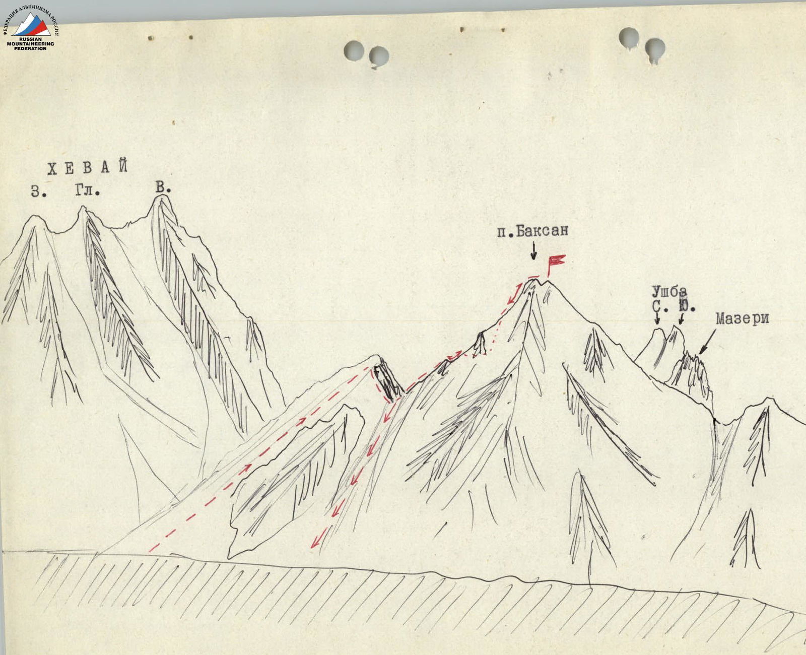
Panoramic drawing of Baksan peak and surrounding peaks from the west (from "Khevai bivouac")
The area adjacent to the Nakra valley, almost forgotten after the closure of the alpine camp with the same name, has been rediscovered in recent years by Baksan group camps, which practice sending groups of climbers for 7-10 day training ascents.
Despite the difficulties and long approaches (12-16 hours), training work in this area is highly effective due to:
- a large number of classified routes of 2A-5A category;
- proximity of peaks to the base camp;
- absence of a "queue" for routes, so typical for Baksan valley.
The base camp is usually set up at the confluence of Kvish and Khevai glaciers, on the scree of a spur branching off from Ledeshgt peak, behind the right-bank ancient moraine of Khevai glacier (so-called Khevai bivouac).
However, known difficulties arise from the lack of sufficient 2B and 3B category routes in the area.
To fill this gap, during the Nakra trip of "Baksan" alpine camp trainees in July 1977, camp instructors Master of Sports A.V. Pakhomova and first-category climber Yu.A. Guryan made a first ascent of an unnamed peak in the Khevai bivouac area. The ascent took place on July 16, 1977.
The peak is located in a short spur descending from East Khevai peak southwards towards Dolra valley and bounding the Khevai glacier basin on the left. From Khevai bivouac, it appears as a regular pyramid directly opposite the bivouac across Khevai glacier.
The team departed from Khevai bivouac at 8:00 am. The path initially goes up the right-bank moraine of Khevai glacier, then above the icefall, crosses the glacier, and ascends snow slopes to the south cirque of Khevai glacier under the slopes of the eponymous peak.
From the cirque, snow slopes lead to a small rocky outcrop in the south spur of East Khevai. Below the outcrop, there is a traverse of a steep snow slope (2 ropes, belay) and a descent of 2 ropes to a snow saddle at the beginning of the peak's northern ridge. Time from bivouac — 2 hours.
Further, the path follows narrow rocky-scree ledges on the left side of the ridge (climbing is straightforward but requires careful belaying off belays) until a large gendarme blocks the ridge path, formed by two smooth walls converging at an acute angle and slightly overhanging, resembling a ship's prow (gendarme "Rostr"). Bypassing this gendarme is the key section of the route. It is bypassed on the left:
- Careful belaying is used to cross a steep scree couloir.
- Ascend a 3-meter smooth wall with a wide crack (difficult climbing with a rightward lean).
- Traverse 10 m along a narrow ledge to the base of a wide, steeply rising internal corner.
- On the left side of the internal corner, there is a 25 m ascent to the ridge (belays off belays, moderate complexity climbing).
Along an easy ridge, initially gently rising, then almost flat and snow-covered, the team reached the summit. The team reached the summit at 11:45, 1 hour 45 minutes from the saddle.
Descent followed the ascent route to the saddle, then:
- Leftwards down a snowy couloir (scree below) to Khevai glacier below the icefall.
- Crossing the glacier, avoiding numerous crevasses (the glacier is open here).
- Over the moraine ridge — back to the bivouac.
Time from summit to bivouac — 2 hours.
Comparing the height with neighboring peaks, the unnamed peak is estimated to be around 3500 m. The team assessed the route as 2B category and considers it suitable for training ascents for 3rd-4th stage trainees.
At the initiative of the camp's instructional staff, the first ascenders propose the name "Baksan" peak for the summit, in honor of one of the oldest alpine camps in the country, and request that the Classification Committee of the USSR Alpine Federation approach the relevant authorities to officially approve the name.
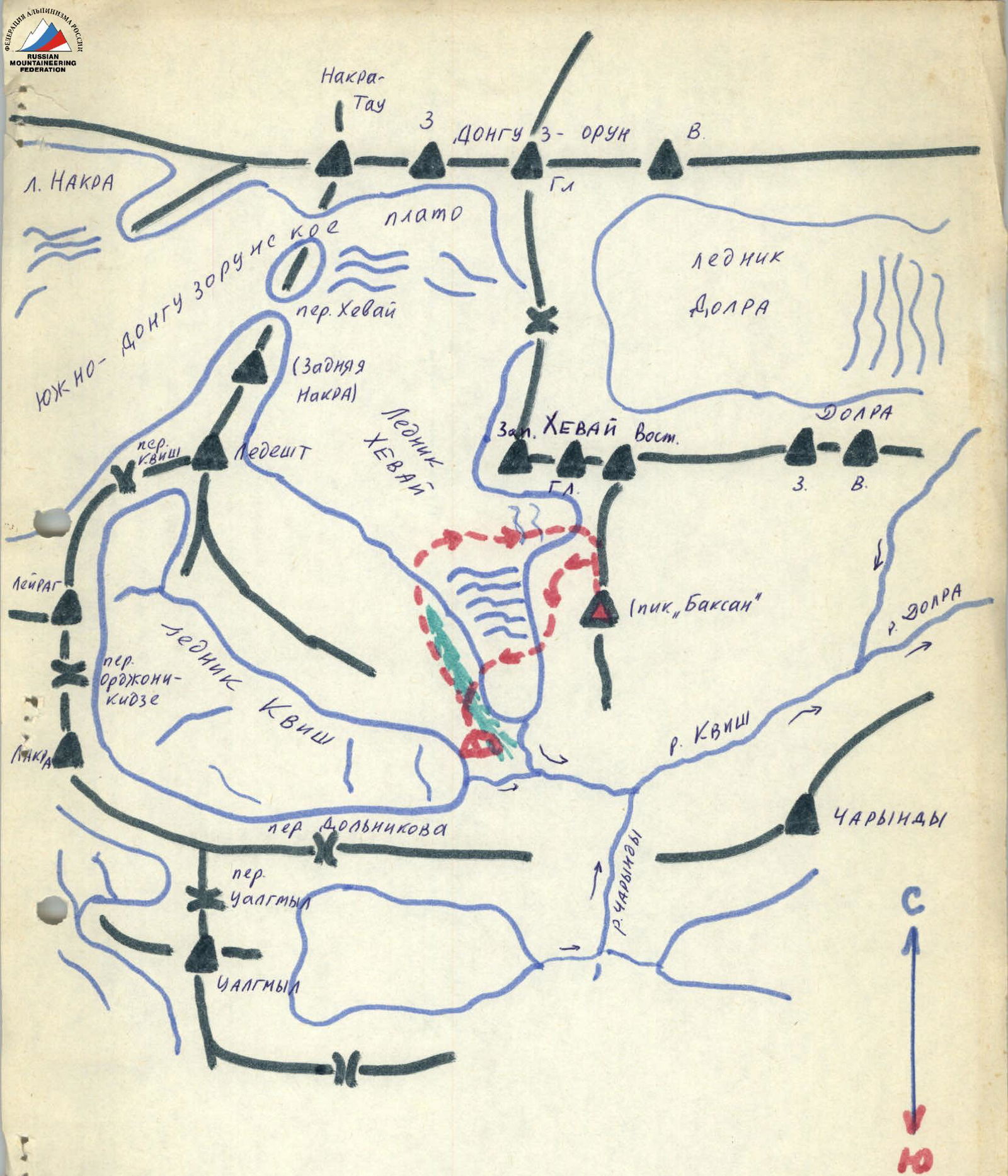
Area map of the ascent