REPORT
On the first ascent to the summit of Kullumkol
VIA THE ROUTE "NORTH-WESTERN SLOPE" CAT. 3B
BY THE TRAINING DEPARTMENT OF THE ALPCLUB "POLITECHNIK" ON AUGUST 1, 2022
St. Petersburg 2022
I. Ascent Passport
| № | 1. General Information | |
|---|---|---|
| 1.1 | Full name, sports rank of the leader | Molodozhen V.A., Master of Sports |
| 1.2 | Full name, sports rank of the participants | Borisova I.E., 3rd sports rank; Egorov I.A., 3rd sports rank; Rylkov E.N., 3rd sports rank; Filippova D.A., 3rd sports rank |
| 1.3 | Full name of the coach | Molodozhen V.A., Master of Sports |
| 1.4 | Organization | Alpclub "Polytechnic", St. Petersburg |
| 2. Characteristics of the ascent object | ||
| 2.1 | Region | Caucasus, from the summit of Gumachi to Kitchlard Pass (Adyrsu, Lekzyr, Chegem gorges) |
| 2.2 | Gorge | Sullukol gorge, Sullukol glacier |
| 2.3 | Section number according to the 2020 classification table | 2.4.1 |
| 2.4 | Name and height of the summit | Kullumkol, 4141 m |
| 2.5 | Geographical coordinates of the summit (latitude/longitude), GPS coordinates | 43°15′07.1″N 42°50′50.1″E (43.251970, 42.847260) |
| 3. Characteristics of the route | ||
| 3.1 | Route name | Via the North-Western slope |
| 3.2 | Proposed category of difficulty | 3B |
| 3.3 | Degree of route exploration | First ascent |
| 3.4 | Route terrain character | Ice-snow |
| 3.5 | Route elevation gain (altimeter or GPS data) | 558 m |
| 3.6 | Route length (in meters) | 1420 m |
| 3.7 | Average slope | Main part of the route — 40–45°, key section of the route — 50–55° |
| 3.8 | Technical elements of the route (total length of sections with varying difficulty and terrain character) | Snow slope up to 30° — 370 m. Ice slope 40–45° — 400 m. Ice slope 50° — 40 m |
| 3.9 | Descent from the summit | via the "North-Eastern ridge" route, cat. 2A to Kullumkol Pass |
| 3.10 | Additional route characteristics | - |
| 4. Characteristics of the team's actions | ||
| 4.1 | Time taken (team's walking hours, in hours and days) | 10 hours 30 minutes |
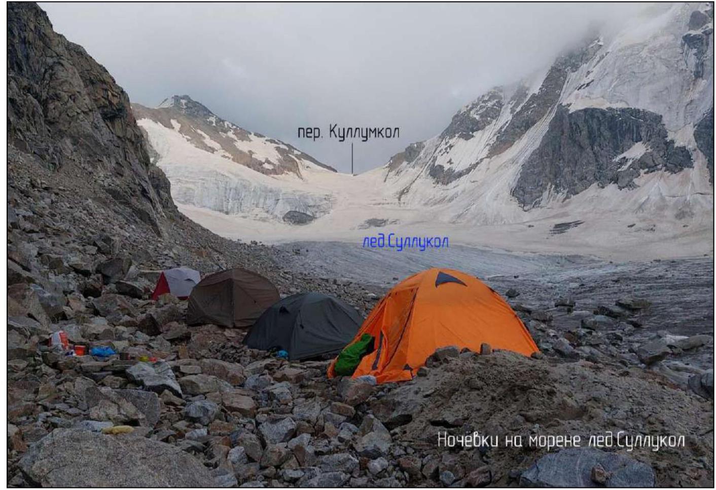
| 4.2 | Overnight stays | on the moraine of the Sullukol glacier |
| 4.3 | Start of the route | 3:00 on August 1, 2022 |
| 4.4 | Summit ascent | 10:40 on August 1, 2022 |
| 4.5 | Return to base camp | overnight stay on the moraine of the Sullukol glacier at 13:30 on August 1, 2022. overnight stay on Shogentsukova's shoulder at 16:50 on August 1, 2022. Base camp (Ullu-Tau Alpine Base) at 20:15 on August 1, 2022 |
| 5. Person responsible for the report | ||
| 5.1 | Full name, e-mail | Egorov I.A. Simonovpp@mail.ru |
II. Ascent Description
1. Characteristics of the Ascent Object
1.1. General Photo of the Summit
Photo 1. North-Western slope of Mt. Kullumkol, main technical section of the route (ascent line marked in red).
to the summit of Kullumkol
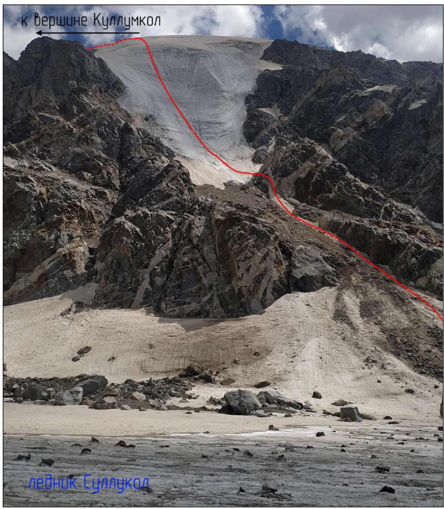 Sullukol glacier
Photo taken in late July 2022 from the side of the Sullukol glacier.
Photo 2. North-Eastern ridge of Mt. Kullumkol (route marked in red after reaching the ridge, descent route marked in purple, cat. 2A to Kullumkol Pass).
Mt. Kullumkol
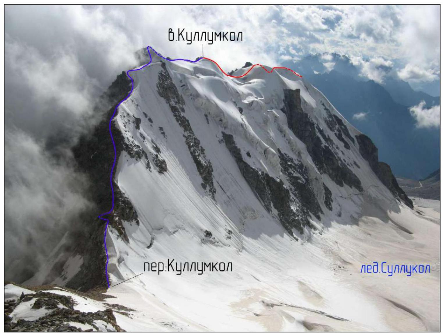 Kullumkol Pass
Sullukol glacier
Kullumkol Pass
Sullukol glacier
Photo taken from the side of the 1st pinnacle of the Tyutyu massif.
1.2. General Description
Mt. Kullumkol is part of the Adyr-Su ridge system of the Central Caucasus (Elbrus region, Kabardino-Balkar Republic). The highly branched Adyr-Su ridge branches off to the north from the nodal summit of the Main Caucasian Ridge — Sarykol (4160 m), separating the Chegem gorge and its continuation — the Bashil gorge from the lateral gorges of the Baksan valley — Adyr-Su, Tyutyu-Su, and Sakashil. The Adyr-Su ridge is a watershed between the Chegem and Baksan rivers.
The first recorded ascent to the summit of Kullumkol was made in 1913 by Russian mountaineer S.Ya. Goluchev via the South-Eastern ridge, cat. 1B.
In 1934, L.A. Gutman made an ascent via the North-Eastern ridge, cat. 2A. This route is used for descent from the ice-snow route via the North-Western ridge, cat. 3B.
1.3. Map of the Area
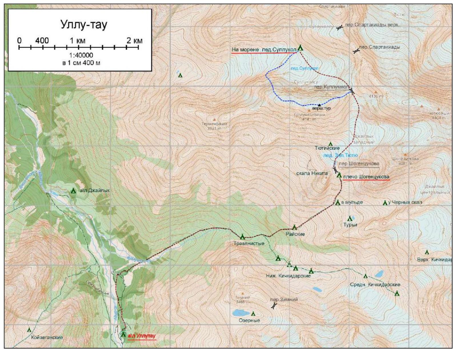
Map of the area:
- Brown dashed line marks the approach from the base camp to the overnight stay on the moraine of the Sullukol glacier.
- Blue dashed line — approach from the overnight stay.
- Route to Mt. Kullumkol "via the NW slope" cat. 3B.
- Descent via the "NE ridge" route cat. 2A to Kullumkol Pass.
Border regime — no border zone permit is required to visit the Kullumkolsu valley and Sullukol gorge.
Approach from the base camp — from the Ullutau alpine camp along the road for 10 minutes to the ruins of the old Dzaylyk alpine camp. To the right along the trail past the remaining houses of the former camp, then along the boulders of the mudflow cone to the bridge over the Kullumkol river (another 10 minutes). After crossing, move along the Kullumkol gorge along the left bank of the river.
After passing the semi-destroyed remains of the koshu, in 20–30 minutes, you will see a branch of the trail to the left up to the moraine towards the Tyutyu overnight stays, from where the mudflow that destroyed the Dzaylyk alpine camp once came.
Continue moving towards the Rayskie overnight stays along the Kullumkol river, crossing its numerous streams washed away by mudflows. Cross the river along the stones and you will find yourself at the fork of the trail. To the right — towards the Kichkidarskie overnight stays, to the left — towards the Rayskie overnight stays. Move to the left, to the steep ascent. Along the steep ascent, climb to the Rayskie overnight stays. In the center of the grassy ascent, there is a clearly marked "downhill" trail, or the so-called "lift", and next to this downhill trail, there are good, convenient steps on the grassy slope. From the Rayskie overnight stays, cross the stream, ascend along the trail, then along the middle talus, orienting by the stone cairns. In an hour's walk from the Rayskie overnight stays, there will be a so-called "mulda" between the median moraines coming from the Western Dzaylyk and Western Tyutyu glaciers. Turn left 90° and, crossing the stream flowing from the Western Tyutyu glacier, move up along the trail marked by cairns along the system of talus ascents to the Peschaniye overnight stays and further to Shogentsukov's shoulder. There are many equipped places for tents on the shoulder.
Further:
- Move left up along a good trail to Shogentsukov Pass.
- Then descend to the Western Tyutyu glacier.
- Move along the open part of the glacier towards Kullumkol Pass.
Overcome the ascent on the glacier from the right side along the snow or stones. Then move along the closed glacier under Kullumkol Pass. Overcome the talus pass ascent of about 50 m. Then descend along the steep snow slope towards the Sullukol glacier. Depending on the season, there may be an open bergschrund at the top of the pass. After descending to the glacier, move along its right side to a pronounced moraine where you can set up an overnight stay.
From the alpine camp to the overnight stay on the moraine of the Sullukol glacier is about 9–10 hours. Such a transition within a day is only suitable for a well-acclimatized group.
Overnight stays — on the moraine are organized 4 places for 3–4-person tents. Under the moraine, a stream with clean glacial water flows. The approach to the start of the route from the overnight stays across the open Sullukol glacier takes no more than 30 minutes.
Communication — radio communication with the base camp from the overnight stays is satisfactory, but often requires relaying information through groups on Shogentsukov's shoulder.
Photo 4. Overnight Dusk on the moraine of the Sullukol glacier, late July 2022.
2. Characteristics of the Route
2.3. Technical Characteristics of the Route Sections
| Section № | Terrain Character | Category of Difficulty | Length, m | Type and Number of Pitons |
|---|---|---|---|---|
| R0–R1 | Talus couloir, snowfield, up to 30° | up to 30° | 70 m | insurance via ice axe |
| R1–R2 | Ice slope 40–45° | 40–45° | 200 m | ice screws |
| R2–R3 | Ice slope up to 50° | up to 50° | 40 m | ice screws |
| R3–R4 | Ice slope 40–45° | 40–45° | 200 m | ice screws |
| R4–R5 | Snowy wide ridge with gentle ascents up to 30° | up to 30° | 300 m | insurance via ice axe |
3. Characteristics of the Team's Actions
3.1. Brief Description of the Route Passage.
Section R0–R1 is visible from the glacier, representing a talus couloir located above the outwash cone. Move up along the rock wall to the right. Recommended to pass before sunrise over firn.
Movement:
- Simultaneous
- Insurance via ice axe
Caution, falling stones.
Sections R1–R4 — wide ice slope with a steepness up to 50°. Simultaneous movement. Insurance with ice screws. On section R3–R4, there are bergschrunds filled with snow. R1–R4 — insurance via ice screws.
Sections R4–R5 — wide snowy ridge, with two snowy-icy ascents with a steepness up to 30°. Simultaneous movement. Insurance via ice axe.
Route on UIAA signs (route line in red).
Kullumkol, 4141 m.
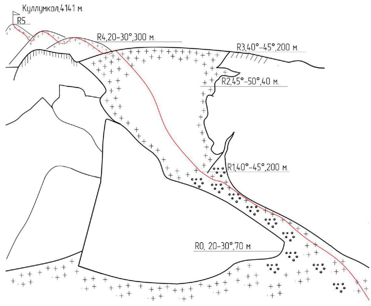 Route sections marked on the map-scheme:
- R5
- R4, 20–30°, 300 m
- R3, 40–45°, 200 m
- R2, 45–50°, 40 m
- R1, 40–45°, 200 m
- R0, 20–30°, 70 m
- Sullukol glacier
| Section № | Description | Photo № |
|---|---|---|
| R0–R1 | From the glacier up and to the right along the outwash cone, then along the rock wall to the right to the beginning of the ice tongue. (+1:30 from the overnight stay) | 5 |
| R1–R2 | Up along the wide ice tongue to the steep section. (+3:00) | 6–10 |
| R2–R3 | Overcome the steep ice section (40 m). (+4:00) | 11–13 |
| R3–R4 | Along the flattening ice slope, exit to the snowy ridge. (+6:00) | 14–15 |
| R4–R5 | Left along the wide ridge, overcoming two gentle snowy-icy ascents, exit to the summit. (+7:00) | 16–18 |
Descent from the summit via the "North-Eastern ridge" route cat. 2A to Kullumkol Pass.
Geographical coordinates (latitude–longitude), GPS coordinates —
Overnight stay — 43°15′38.7″ N 42°50′25.8″ E (43.260740, 42.840490)
Start of the technical part (after passing the couloir) — 43°15′22.7″ N 42°50′08.8″ E (43.256300, 42.835770)
Summit ascent (cairn) — 43°15′07.1″ N 42°50′50.1″ E (43.251970, 42.847260)
Kullumkol Pass — 43°15′15.9″ N 42°51′12.1″ E (43.254410, 42.853370)
Photo 5. Passage of the couloir, movement along the rock wall towards the beginning of the ice tongue. Caution, falling stones. (R0–R1)
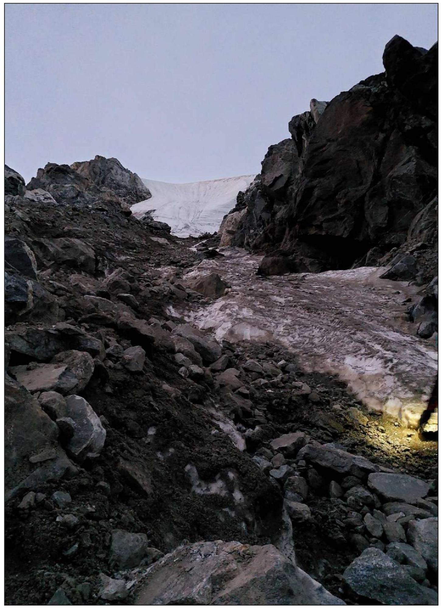
Photo 6. Start of movement along the wide ice tongue towards the steep section (R1–R2)
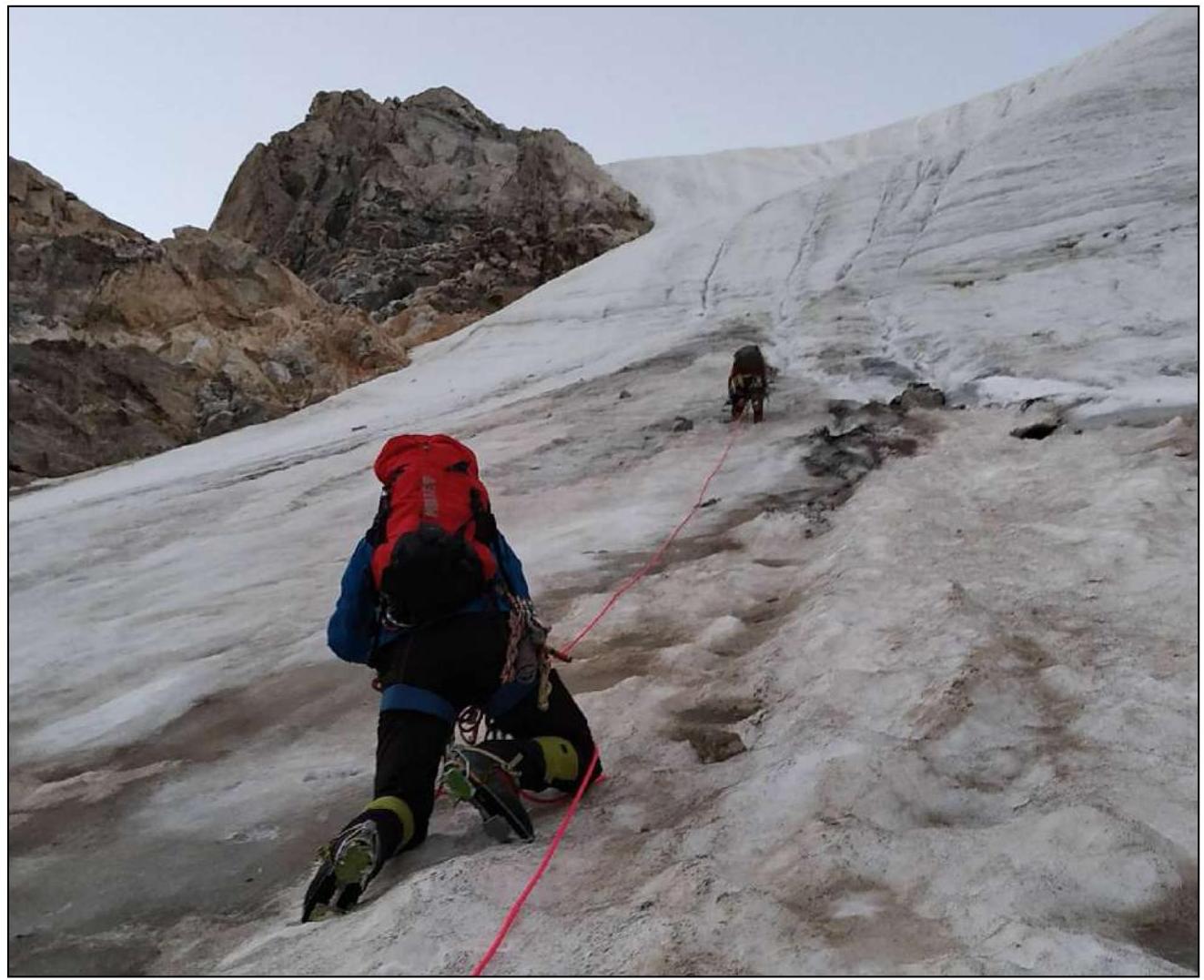
Photo 7. Ice slope (R1–R2)
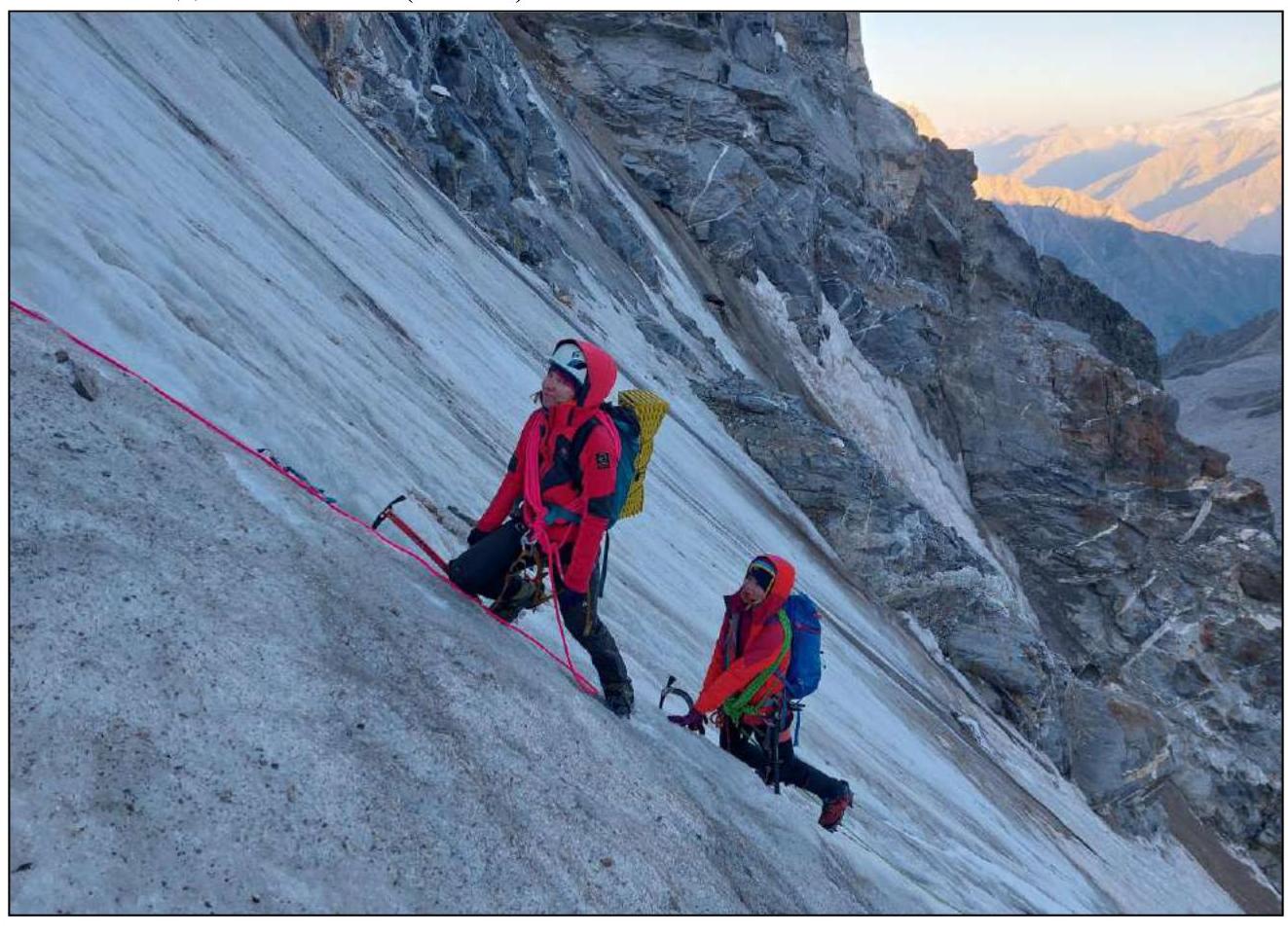
Photo 8. Upper part of section (R1–R2)
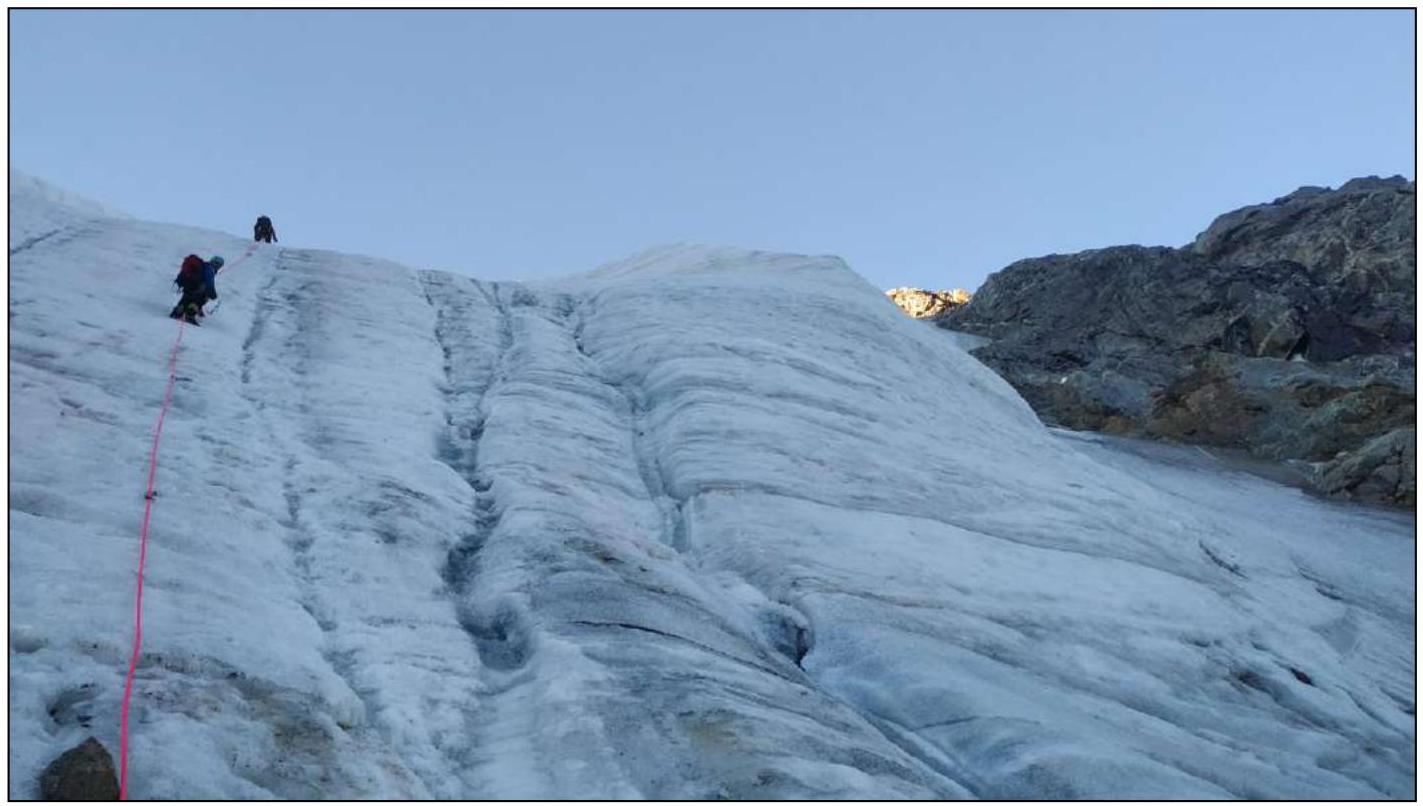
Photo 9–10. Passage of section R1–R2
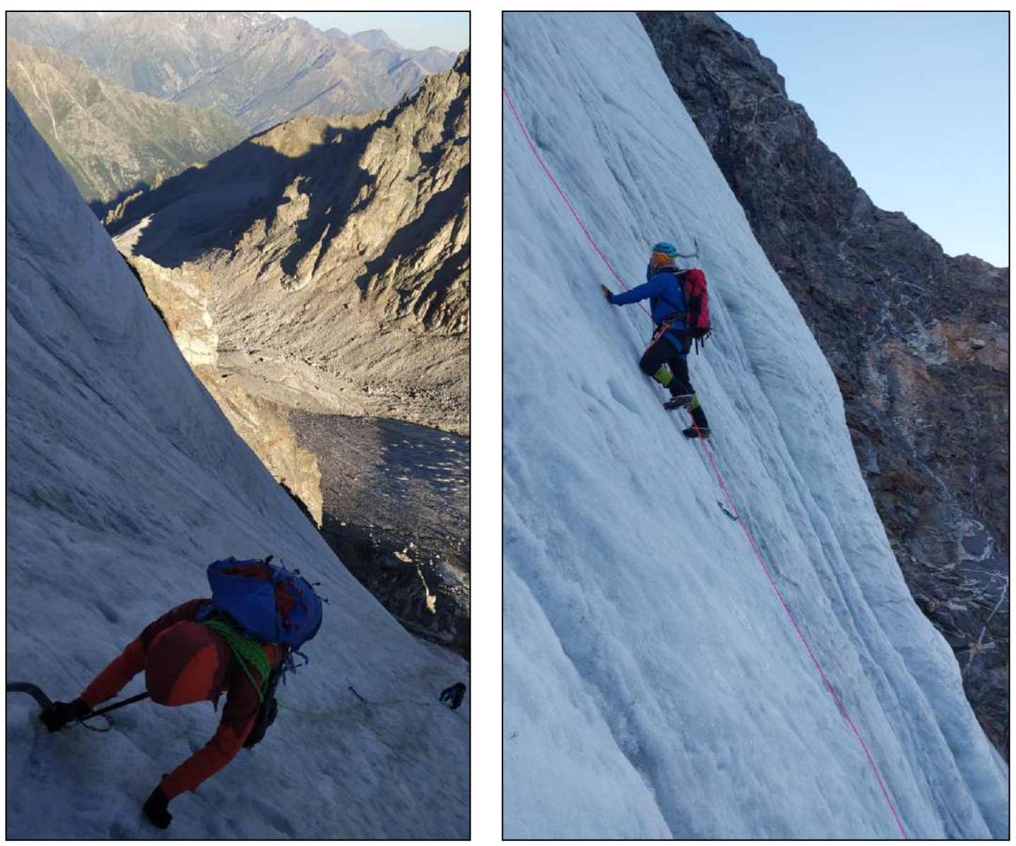
Photo 11. At the start of the steep ice section — the key to the route (R2–R3)
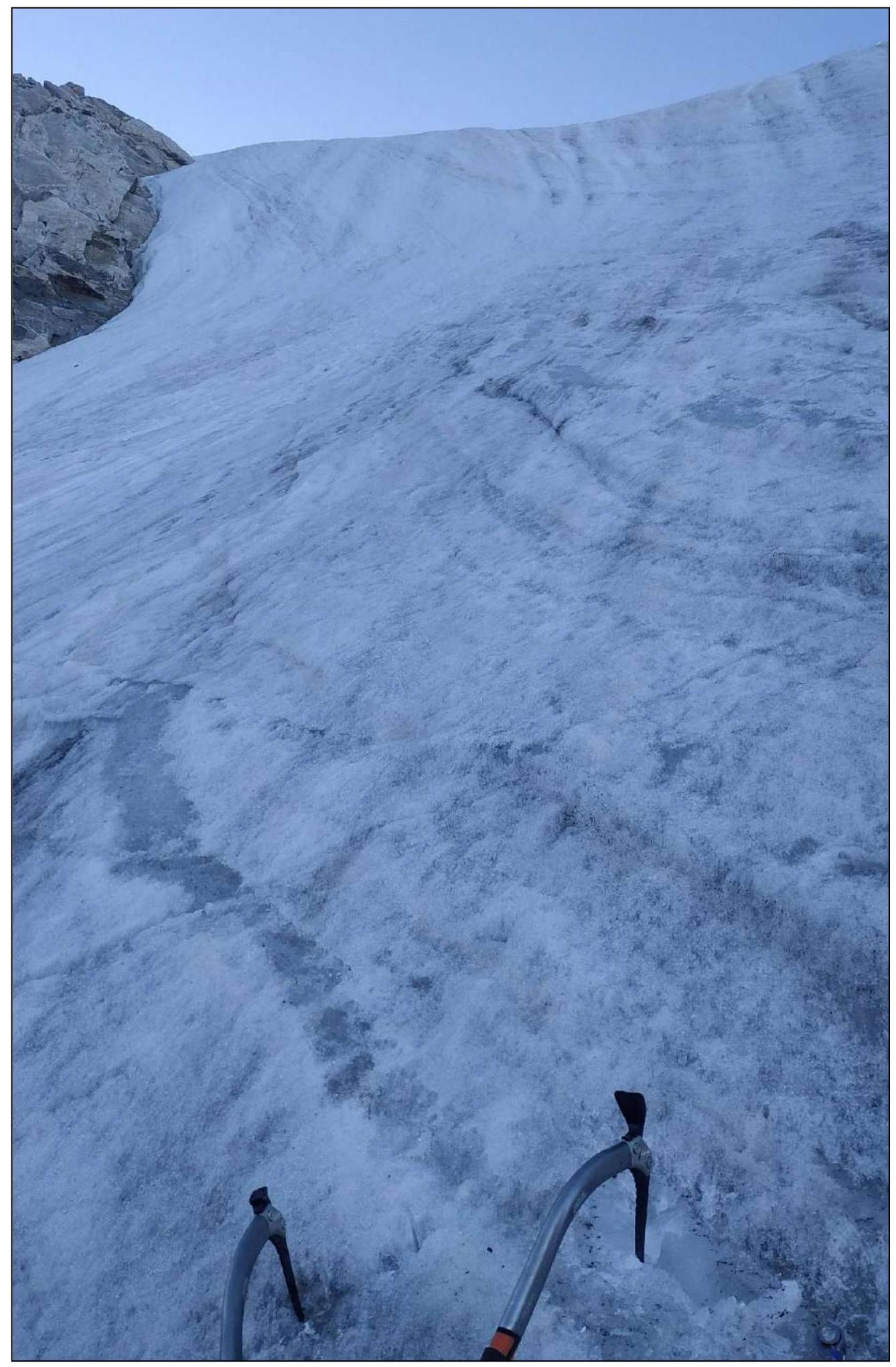
Photo 12. Start of movement along the steep ice section (R2–R3)
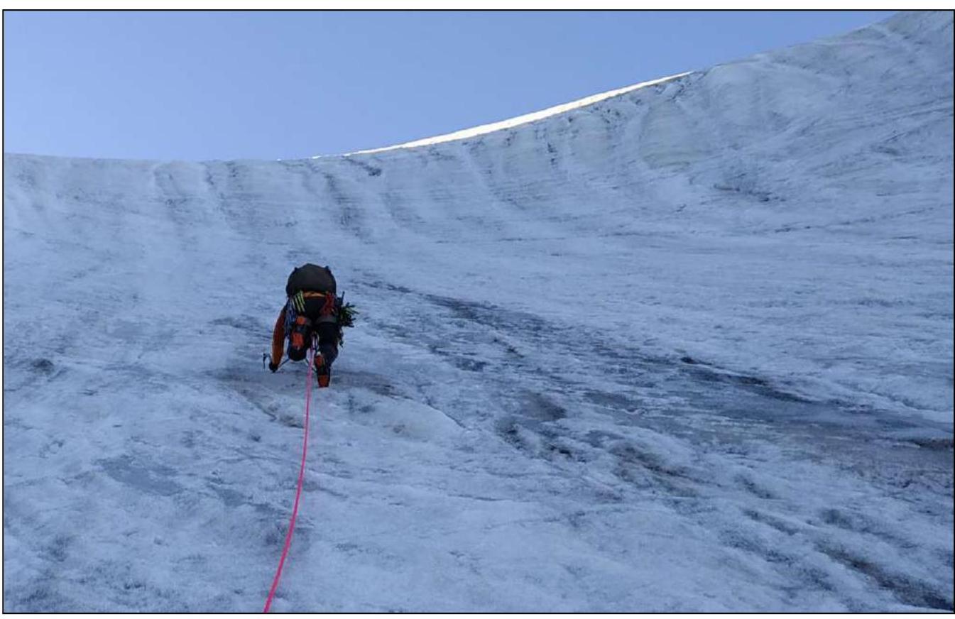
Photo 13. Passage of the key section (R2–R3)
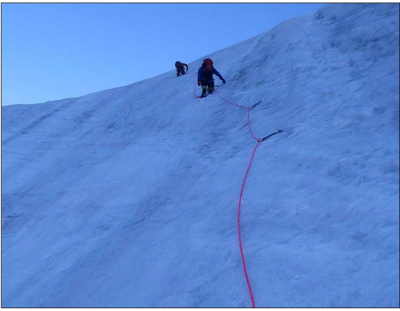
Photo 14. Flattening ice slope (R3–R4)
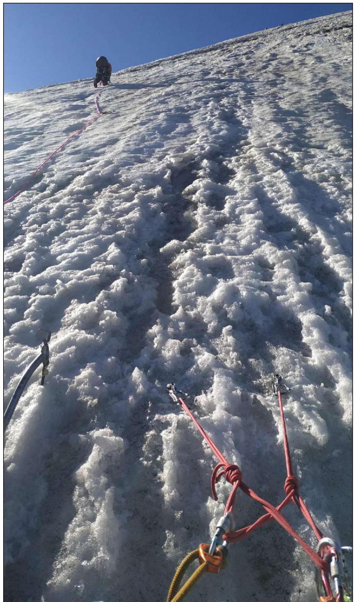
Photo 15. Section of the snowy-icy ridge (section R3–R4)
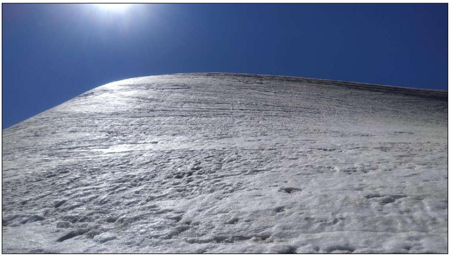
Photo 16. After exiting to the snowy ridge (section R4–R5)
Tyutyu massif
Mt. Kullumkol
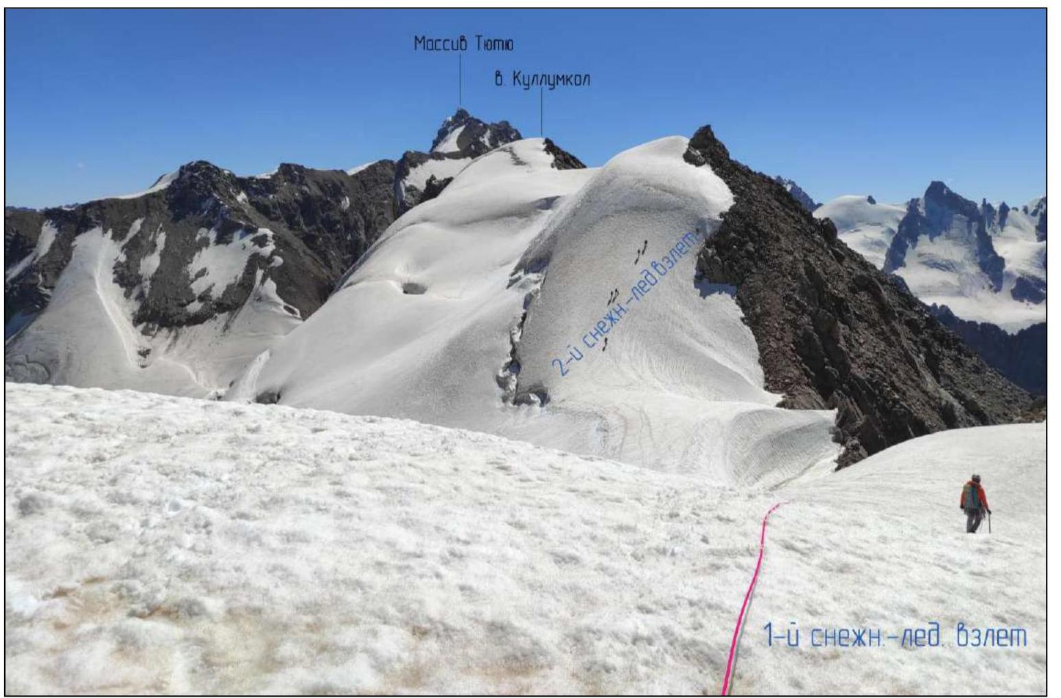 2nd snowy-icy ascent
1st snowy-icy ascent
2nd snowy-icy ascent
1st snowy-icy ascent
Photo 17. Taken from the pre-summit ascent of Mt. Kullumkol towards Mt. Elbrus and the 2nd snowy-icy ascent (section R4–R5)
Elbrus
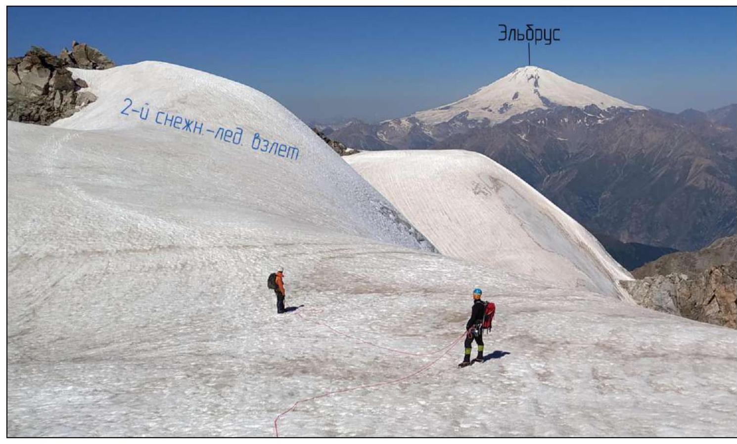 2nd snowy-icy ascent
Photo 18. Summit of Kullumkol (section R4–R5)
Mt. Kullumkol
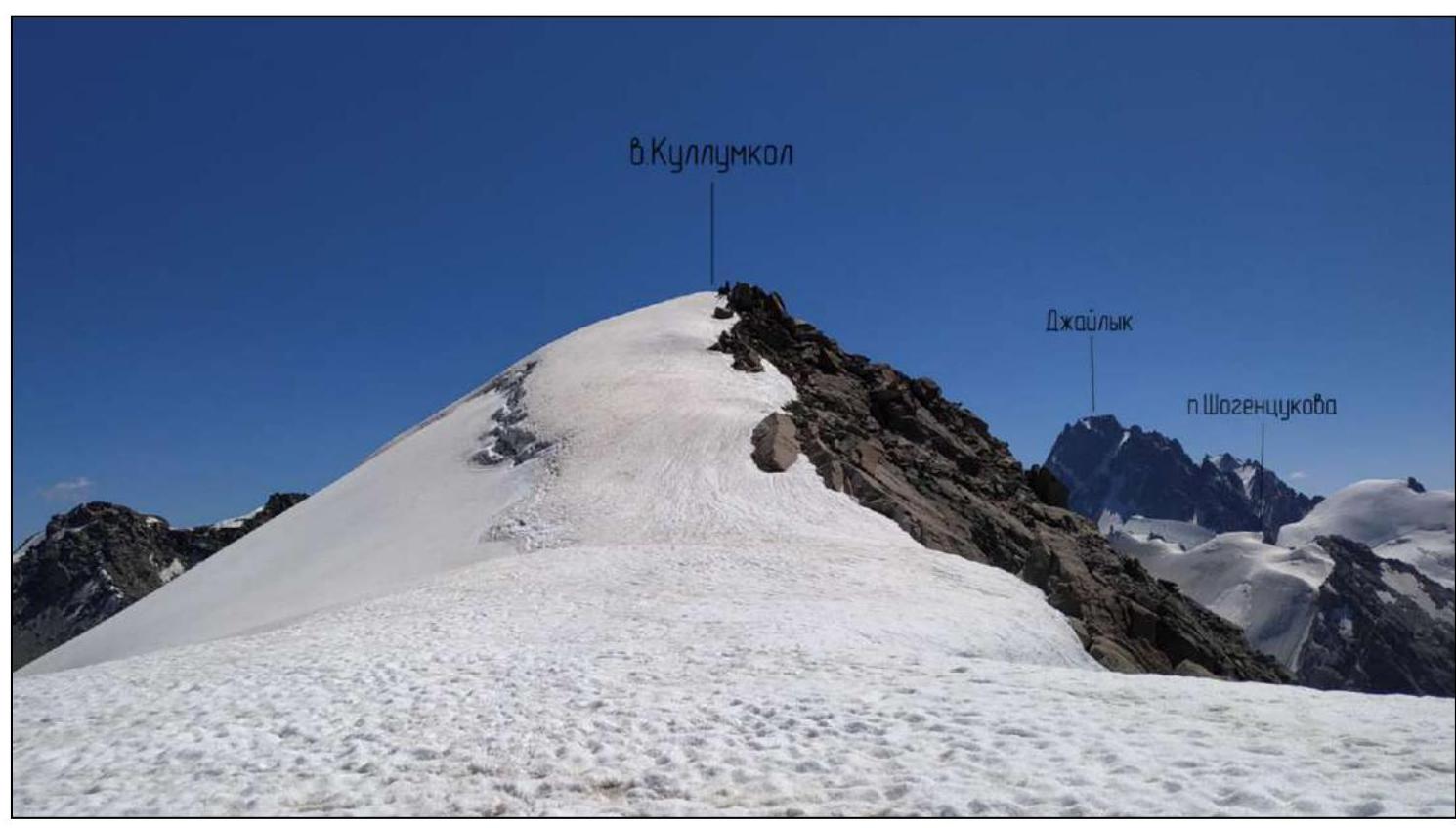 Dzaylyk
Shogentsukov Pass
Dzaylyk
Shogentsukov Pass
3.3. Overall Route Assessment.
The first part of the route is prone to rockfall, recommended to pass before sunrise. Further, the route follows a logical line, is safe, and orientation is not challenging. The highlight of the route is the wide snowy ridge, offering a view of two valleys.
Insurance on the route is primarily with ice screws. For descent, it is recommended to have a set of protection gear.
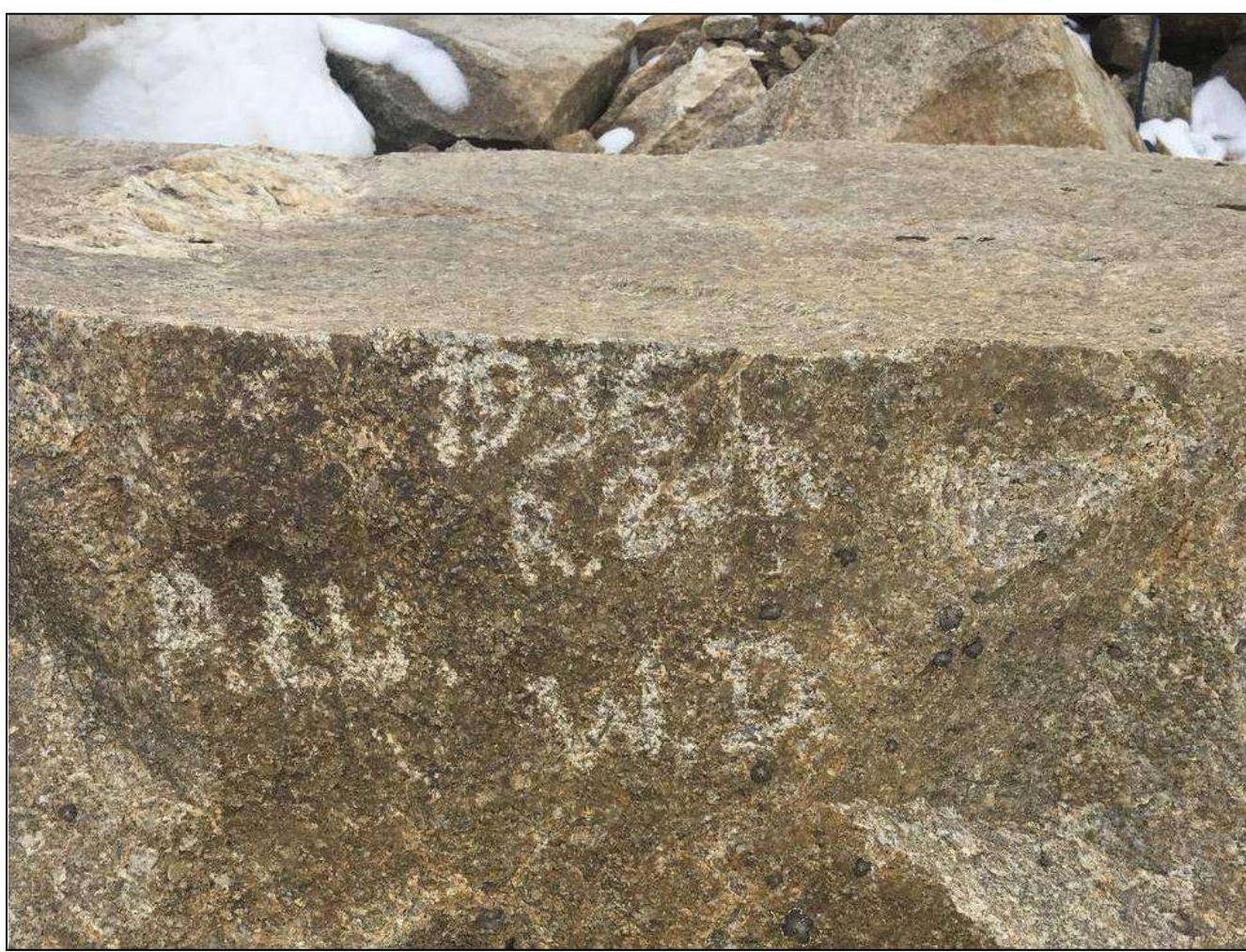
At the end of the descent, 10–15 m from Kullumkol Pass, you can touch history and see a stone with initials and the date "1936", left presumably by Austrian or German mountaineers in 1936.