Passport
- Climbing category — technical;
- Main Caucasian Range and its spurs from Chipperazau Pass to Ortokara peak, Adyrsu-Dzhailyk spur;
- Yunom peak, 4365 m, via the West Face;
- Category 4A, first ascent;
- Height difference: 500 m; Distance: 960 m; Distance of category 4-5 sections: 135 m; Average steepness of the main sections: 58°;
- Pitons driven:
| Rock | Bolt | Nuts | Ice |
|---|---|---|---|
| 8/2 | 0/0 | 25/0 | 0/0 |
-
Team's climbing hours: 18.5 (not including descent) and days — 2;
-
Overnight stays: 1 — on a rock ledge, semi-reclined;
-
Leader: Alexander Rasskazov, Master of Sports of the USSR;
Participants: Evgeny Ogurtsov, 1st sports category, Oleg Makalov, 2nd sports category, Boris Gorbunov, 2nd sports category;
-
Coach: Yuri Porokhnya, Honored Master of Sports of the USSR;
-
Approach to the route: July 6, 2007.
Summit: July 8, 2007. Return: July 9, 2007.
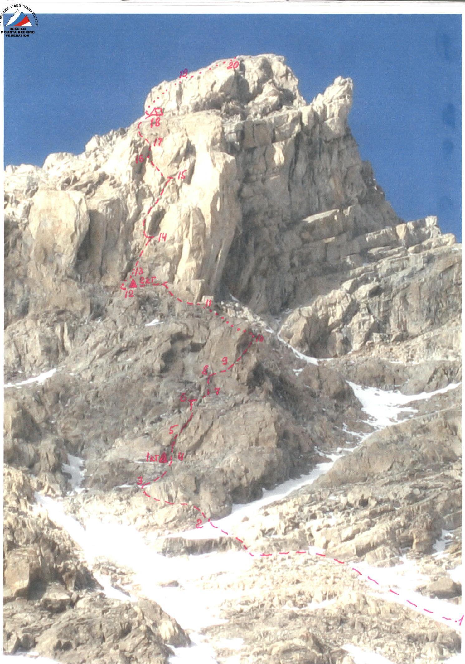
Photo 1. General view of the West Face of Yunom peak. AREA MAP M 1:100 000

Legend:
AUSF "Ullutau"
Middle Kichkidar overnight stays
Yunom peak
— approach route
— return route
 www.alpfederation.ru↗
Team's Tactical Actions
July 6, 2007. At 7:00, the team left AUSF "Ullutau" and arrived at the Middle Kichkidar overnight stays at 11:30, set up a bivouac.
On the same day, a reconnaissance of the approach route to the wall was carried out, and a visual inspection of the route options was performed; a possible route was chosen. The planned route passes through the wall located between the SW ridge and the Freshfield Pass, with a predominantly western orientation.
July 7, 2007. At 5:30, the team left the bivouac and, traversing the talus, passed along the left edge of the Yunom glacier and further up the steep snow "tongues" alternating with talus sections (snow firn was traversed in crampons), and after 3.5–4 hours, approached the route. The path goes to the right of the rocky walls of the slope at the base of the SW ridge of Yunom peak.
By passing the lower rock island on the right, they reached the right part of the island with characteristic vertical black streaks on its left side, where they roped up and began moving in teams: Rasskazov — Ogurtsov and Makalov — Gorbunov.
By traversing left and up along a rock terrace for 40 m (station), and then ascending 15 m up simple rocks of category 3 to a ledge, they set up the 1st control cairn to mark the beginning of the route.
Further, 15 m (40°, category 3) to the left of the cairn, then 35 m (80°, category 4) up to the next station, from which a 5 m traverse to the right (category 3), an ascent of 20 m (80°, category 4), and a 20 m traverse to the right (category 3), station. From it, a 30 m traverse to the right along the terrace (rocks, 15°, category 2) to the exit (station) into a steep talus couloir, an ascent of about 50 m through it, and further about 30 m along a snow "tongue" to a large terrace, in the left part of which, at the base of a steep internal corner, the 2nd control cairn was set up.
From the 2nd control cairn, an ascent of 30 m (75–80°, category 4) up the right part of the internal corner to a niche with an overhang, station.
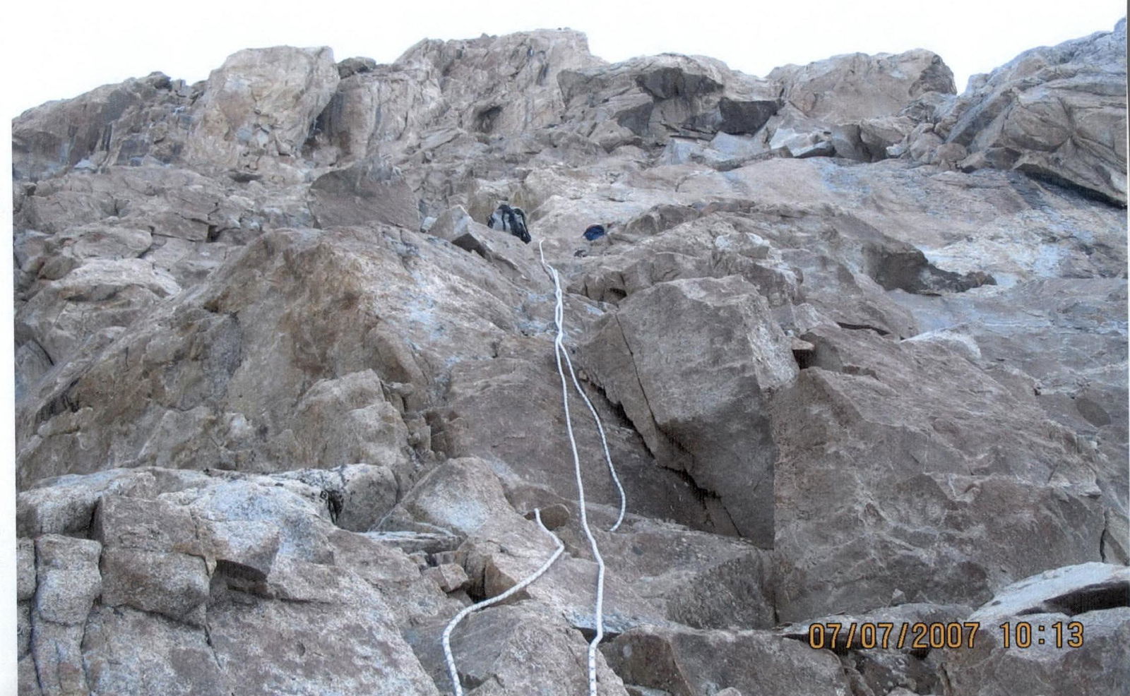
From this moment on, the further ascent occurred in conditions of suddenly arrived bad weather (snow pellets, wind, thunderstorm), which made it practically impossible to wait out, and the team was forced to continue moving through this actually key section. Unfortunately, the bad weather made it impossible to take any photos of this and further sections of the route.
The section passes:
- 40 m up from the niche
- Up complex rocks of a wide internal corner (80–85°, category 5)
- To a small chip from the overhanging rock "feathers" to the right.
Station, where it's hard to gather the whole group. From the station, 10 m (45°, category 4) up and left along an inclined slab-terrace with a small number of holds and a crack on the right side to the base (station) of a 5-meter narrow chimney with a black inner wall (90°, category 5), after which 40 m (50°, category 3) up and right along inclined slabs to a wall with a small chip, to the left of which a narrow snow couloir is located.
At this point, the group was forced to organize an overnight stay due to bad weather and the onset of darkness. The overnight stay was sitting, as there was no place to set up a tent, as was the case for almost the entire route. July 8, 2007. At 7:00, the group continued moving. From the overnight stay location, 30 m (40°) up the snow couloir — exit to snow-covered slabs, along which 40 m (30°, category 3) — exit to a saddle on the SE ridge (onto the category 2B route). From the saddle, about 100 m along ledges and heavily destroyed rocks — ascent to the summit of Yunom. The team reached the summit at 11:30. The descent along the category 2B route to Freshfield Pass and further to the bivouac took about 6.5 hours.
July 9, 2007. The team's return to AUSF "Ullutau" at 14:30.
Conclusions and Recommendations:
- The route is quite safe, there are not many "live" stones, and no spontaneous stonefall was observed;
- There were no places for a tent bivouac on the wall section of the route, except for the terrace near the 2nd control cairn, where a platform can be built. It is recommended to complete the route within daylight hours.
Route Description by Sections
R0–R1 — 2500–3000 m, 15°–20° From the initial bivouac along talus, left (in the direction of travel) edge of the Yunom glacier to the slopes descending from Freshfield Pass;
R1–R2 — 400–500 m, 25°–30° — ascent along snow "tongues" alternating with talus sections, bypassing the SW ridge of Yunom peak, in the upper part — along a snow couloir bypassing the lower rock island;
R2–R3 — movement left and up for 40 m, 20°–30°, category 2;
R3–R4 — ascent along a wide terrace for 15 m, 25°–30°, category 3; the 1st control cairn is built on the left side of the terrace;
R4–R5 — ascent right and up from the cairn along a wide internal corner (15 m, 40°, category 3) and further (R5–R6) up 35 m, 80°, category 4;
R6–R7 — traverse right along a ledge for 5 m, category 2, then (R7–R8) up a wall (20 m, 80°, category 4) and traverse right (R8–R9) for 20 m, 15°, category 3;
R9–R10 — traverse right along a terrace for 30 m, 30°, category 2;
R10–R11 — ascent bypassing a tower along a steep talus slope (couloir) for 50 m, 45°, and further (R11–R12) along a snow "tongue" — ascent to a large terrace, in the left part of which an inclined internal corner is visible. The 2nd control cairn is built at the base of the internal corner.
R12–R13 — ascent along the right part of the internal corner for 10 m, 80°, category 4, turning into a steep wide ridge (R13–R14) — 25 m, 80°, category 4, to an overhang (niche);
R14–R15 — ascent left of the overhang along a wide internal corner (30 m, 80°, category 5) to a small chip from the overhanging rock "feathers" to the right. Station, where it's hard to gather the whole group.
R15–R16 — ascent left and up along an inclined slab-terrace (10 m, 45°, category 4) with a small number of holds and a longitudinal crack on the right side, to the base of a narrow chimney with black walls and a wide chip to the right;
R16–R17 — ascent along the chimney (5 m, 90°, category 5) and further (R17–R18) along slabs (40 m, 50°, category 3) to a small chip under an overhanging wall;
R18–R19 — ascent left of the wall along a snow couloir (40 m, 40°) with an exit right onto inclined slabs above the wall;
R19–R20 — ascent along snow-covered slabs (40 m, 30°, category 3) leading to a saddle on the SE ridge of Yunom peak (onto the category 2B route);
R20–R21 — along the ridge, about 100 m ascent to the summit of Yunom. Descent along the category 2B route to Freshfield Pass and further to the base camp.

Section R2–R3

Section R13–R14


