ASCENT DOCUMENT
I. Ascent classification: technical.
- Ascent area: (in accordance with KTMVG) Caucasus, from Chipperazau Pass to Kitlod Pass.
- Peak, its height and route: Chegem, 4461 m, via the Northwest wall of the Northeast ridge.
- Difficulty category: 5B.
- Route characteristics: height difference 1250 m, average slope of the wall directly 75-80 degrees, average slope of the ascent route 50-55 degrees. Length of sections: 1st category difficulty — 0 m, 2nd category difficulty — 400 m, 3rd category difficulty — 570 m, 4th category difficulty — 330 m, 5th category difficulty — 150 m, 6th category difficulty — 80 m.
- Pitons hammered in:
For belaying:
- Rock: 48
- Ice: 16
- Bolt: 0 For creating artificial support points:
- Rock: 9
- Ice: 0
- Bolt: 0
- Number of climbing hours — 32 hours.
- Number of bivouacs and their characteristics: three bivouacs — 1st on Donkin Pass, 2nd — at the end of the wall before the ridge, 3rd — on Donkin Pass.
- Surname, name, patronymic of participants and their sports qualification:
- Rasskazov Alexander Nikolayevich — Candidate Master of Sports of the USSR
- Petukhov Valery Pavlovich — Candidate Master of Sports of the USSR.
- Team coach: senior instructor, Honored Master of Sports of the USSR Porokhnya Yuri Ivanovich.
II. Date of departure on the route and return: 7-10 August 1979.
TABLE OF MAIN CHARACTERISTICS OF THE ASCENT ROUTE
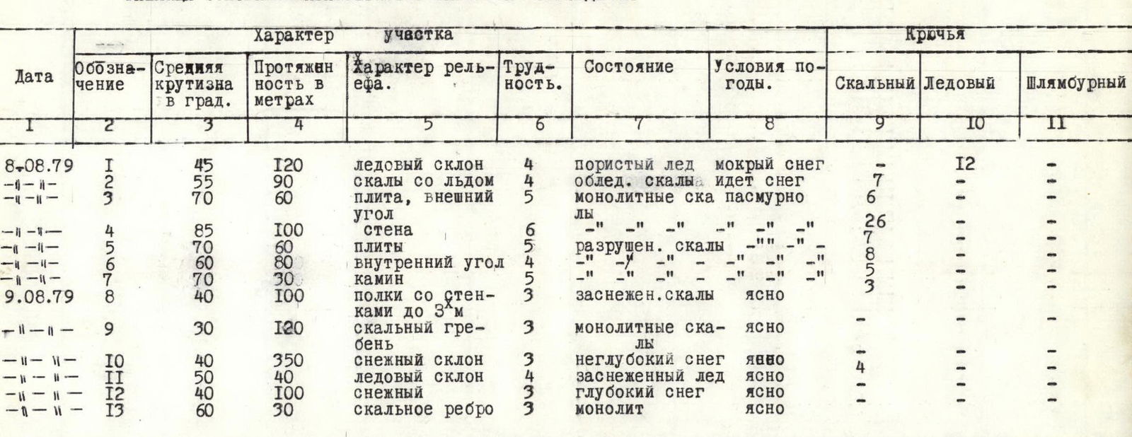
| Date | Designation | Average slope in degrees | Length in meters | Terrain character | Difficulty | Condition | Weather conditions | Rock | Ice | Bolt |
|---|---|---|---|---|---|---|---|---|---|---|
| 8-08-1979 | 1 | 45 | 120 | ice slope | 4 | porous ice | wet snow | 0 | 12 | 0 |
| " | 2 | 55 | 90 | rocks with ice | 5 | icy rocks | snowing | 7 | 6 | 0 |
| " | 3 | 70 | 60 | slab, outer corner | 5 | monolithic rocks | overcast | 6 | 0 | 0 |
| " | 4 | 85 | 100 | wall | 6 | monolithic rocks | overcast | 26 | 0 | 0 |
| " | 5 | 70 | 60 | slabs | 5 | broken rocks | overcast | 7 | 0 | 0 |
| " | 6 | 60 | 80 | inner corner | 4 | broken rocks | overcast | 8 | 0 | 0 |
| " | 7 | 70 | 30 | chimney | 5 | broken rocks | overcast | 5 | 0 | 0 |
| 9-08-1979 | 8 | 40 | 100 | ledges with walls up to 3 m | 3 | snowy rocks | clear | 3 | 0 | 0 |
| " | 9 | 30 | 120 | rocky ridge | 3 | monolithic rocks | clear | 0 | 0 | 0 |
| " | 10 | 40 | 350 | snow slope | 3 | shallow snow | clear | 4 | 0 | 0 |
| " | 11 | 50 | 40 | ice slope | 4 | snowy ice | clear | 1 | 0 | 0 |
| " | 12 | 40 | 100 | snow | 3 | deep snow | clear | 1 | 0 | 0 |
| " | 13 | 60 | 30 | rocky edge | 3 | monolith | clear | 1 | 0 | 0 |
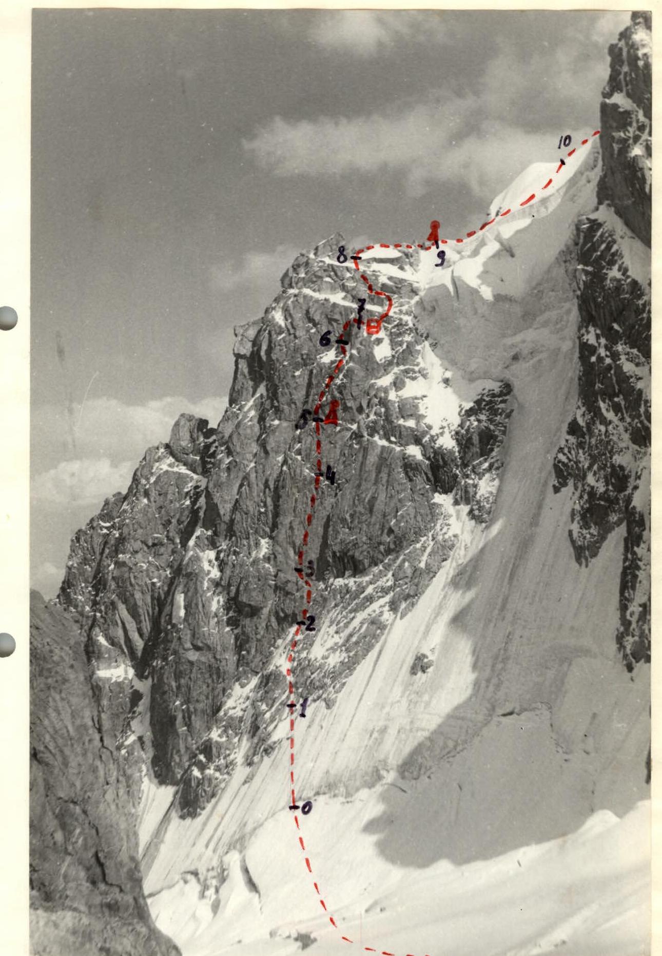
Brief explanation of the table of route sections.
From Donkin Pass, descend and move in the direction of the left northern counterfort. This counterfort is divided into two parts by oblique snow-ice couloirs. Orient towards the right part of the left counterfort. Approach the bergschrund via a snow slope, overcome it, and initially follow a 45-degree ice slope, then rocky outcrops in the ice to reach under an overhanging rocky cornice (section R0-R2). The cornice is passed on the right via difficult rocks, and then exit onto a small ledge (section R2-R3). The left part of the ledge marks the beginning of the key vertical section of the route. Ascend monolithic, very difficult rocks of the wall using ladders, first to an inclined ledge, and then to the next snowy ledge.
Backpacks are pulled up (section R3-R4, 80 m). A sitting bivouac is possible here. Then follow slabs to an inner corner and exit onto a ledge via it. Here is the counterfort (section R4-R5, 60 m). If you descend 10 m down to the left, there's a bivouac spot for 4-5 people. Then follow steep rocks of moderate difficulty (loose rocks!) through an inner corner (section R5-R6, 80 m) to the foot of a chimney, which is overcome by free climbing with piton belays. Behind the chimney lies a small platform; descending from it, a good bivouac can be organized (section R6-R7, 30 m). From the bivouac, move up and left via ledges and rocks of moderate difficulty to exit onto the ridge leading to the summit (section R7-R8, 100 m). Then follow monolithic rocks of the ridge, overcoming two flat gendarmes to reach a snow-ice ridge. On the II gendarme is the 2nd control point (section R8-R9, 120 m). Then approach an ice slope via a snow ( местами exposed ice) slope (section R9-R10, 350 m). The ice slope is overcome using crampons with piton belays (section R10-R11, 40 m). Then move through snow (section R11-R12, 100 m), approach the summit tower via rocks with good handholds and footholds, and exit onto the summit (section R12-R13, 30 m).
Further descent is via the Western ridge in the direction of Donkin Pass following the route of 3A category difficulty.
Bivouac locations during ascent:
- On Donkin Pass.
- On the route, before exiting onto the ridge.
- On Donkin Pass.