
Passport
- Climbing category: ice-snow
- Climbing region: Central Caucasus, Adyr-su region
- Peak, its height and ascent route: Ullutau Main via North-Northwest wall, 4207 m, 5B category, 3rd ascent.
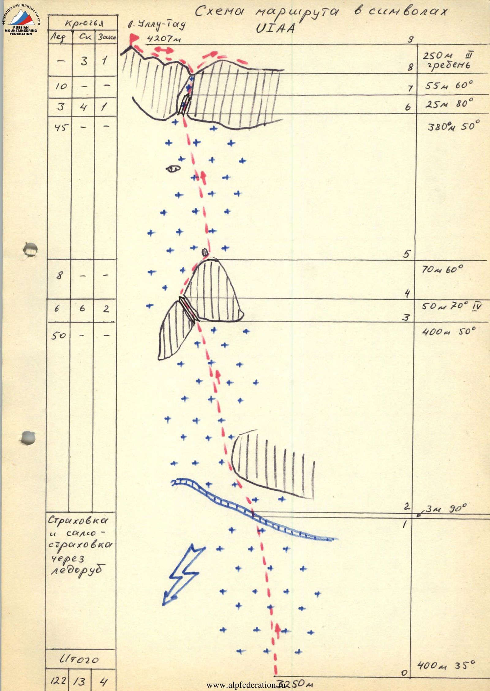
- Route characteristics: height difference — 950 m; average steepness — 47°; route length to the ridge — 1300 m.
- Pitons used: rock 13/0, drilled 0/0, chocks 4/0, ice screws 122/0
- Team's total climbing hours: 9 hours
- Team: leader Kurganov N.V. — Candidate for Master of Sports
Members:
- Erokhin I.D. — Candidate for Master of Sports
- Bezrodny A.V. — Candidate for Master of Sports
- Sklyarov V.V. — Master of Sports
- Team coach: Drobot S.B. — Master of Sports of the USSR, 1st category instructor-methodologist
- Departure to the route — July 23, 1985 Summit — July 23, 1985 Return — July 23, 1985
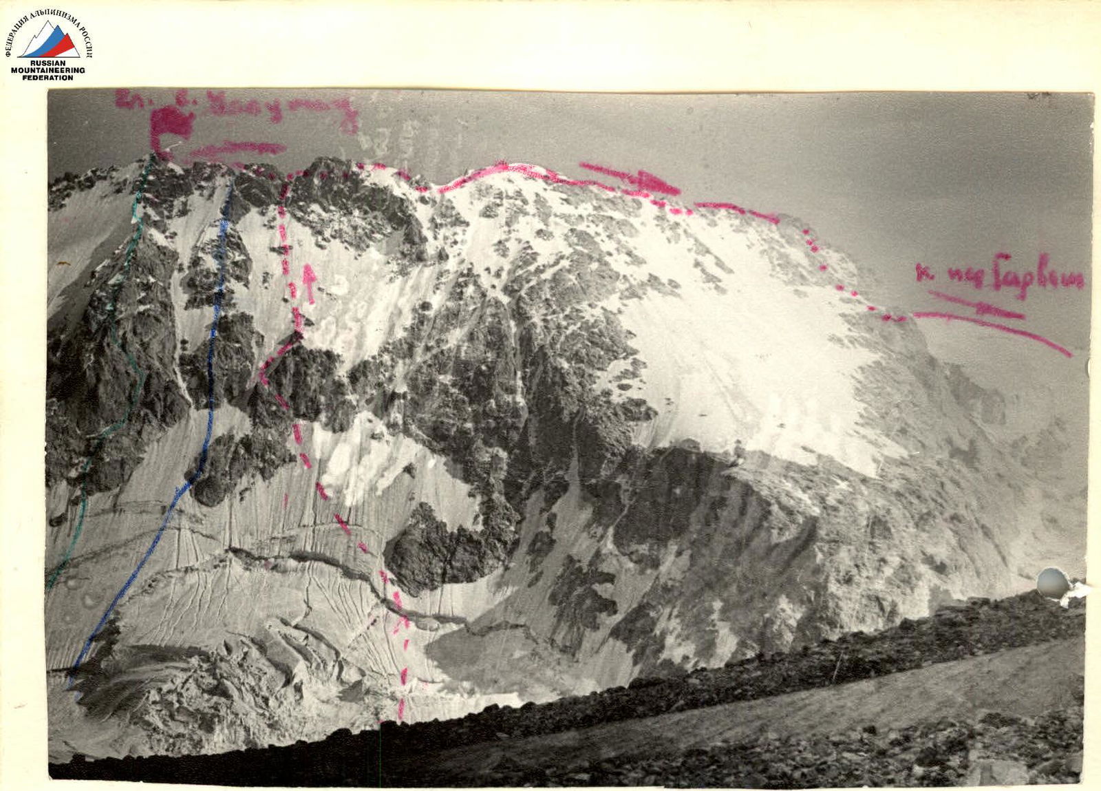
General photo of Ullutau peak
- 1st — via North wall, Abalakov route
- 2nd — via rocky islands of North wall, Western ridge (Maltsev)
- 3rd — via North-Northwest wall (LI V.)
Pre-climb preparation
Preparation for the 1985 RSFSR Alpine Championship in the ice-snow class for the CBASSR team began in January 1985. Candidates for the team were trained according to individual plans in their sections as part of general physical training (GFP). In the last weekends of January, February, and March, trial competitions in GFP were held. The team's special technical training took place on weekends each month: in February — on the rocks and icefall of Tyrnyauz; in March-April — on the Kashkatash glacier. During training, special attention was given to GFP — uphill running; in special technical training — moving in crampons on grassy slopes and rocks, working with "tools" on steep ice. Starting from March, team members completed 5-8 ascents from 2A to 5B category.
The final stage of preparation was a training camp from July 1 to 15 in the Adyr-su gorge at the USAB "Ullutau" base. During the camp, the team passed control standards and made a training ascent to the Adyr-su peak via the ice-snow slope of the Eastern ridge. This route is similar to routes on Ullutau, and the team practiced ice-snow ascent tactics during its passage. Additionally, during the camp, the team studied routes on the Ullutau massif.
The route (Li Di V.) was chosen by the team because it is the longest ice-snow route to the Ullutau peak, and the team was specifically prepared to climb such routes. The tactical plan for the ascent was developed based on experience from ice-snow ascents to the peaks of Mizhirgi, Dykhtau, Ullukara, Ullutau, and the training ascent to Adyr-su, as well as the route's condition and the team's preparedness. Problematic sections of the route included: a bergschrund with a 3-meter snow wall, icy rocks on the "island," and the exit to the ridge. Crossing the bergschrund was planned with the help of ice axes; navigating icy rock sections was prepared for in crampons and with ice axes.
The main safety measures during the route included:
- early passage of the route
- all participants working on a double rope
- changing the lead climber when transitioning from ice to rocks and from rocks to ice
- avoiding having participants work one above the other on ice slopes
- having bivouac equipment and a food reserve
- clear radio communication.
Thus, the team's preparation was focused and at a high sports level.
Team's tactical actions
Movement along the route was in pairs: Erokhin-Kurganov, Bezrodny-Sklyarov.
On the R1-R4 section, the Kurganov-Erokhin pair led; on the R5-R7 section — the Bezrodny-Sklyarov pair.
On sections R1, R2, R5, movement was simultaneous with ice screws placed every 8 m, i.e., 4 ice screws per 25 m. The first in the pair worked with an ice axe and hammer.
On R3 and R4 sections — movement with alternate belay through rock pitons and chocks.
On R6-R7 sections — movement with alternate belay through rock pitons and chocks.
On R8-R9 sections — simultaneous movement, belay through rock pitons, chocks, and ledges.
There were no deviations from the tactical plan, except for the descent from the summit due to poor visibility. (Snow-covered rocks)
The lead climber on the ice-snow slope was changed after they used up their ice screws.
Throughout the route, the group stopped twice to eat (on a rocky island and during the descent).
Safety measures during the route passage are as described in the previous section.
There were no falls or injuries during the ascent.
The problematic sections of the route, as anticipated, were R1, R3, R6, R7.
- R1 section (bergschrund) was overcome with the help of ice axes and stepping up.
- R3 section (wet and icy rocks) was navigated with alternate belay; when transitioning from ice to rocks, the lead climber was changed.
- R6-R7 section (icy couloir) was overcome with the help of an ice axe and ice hammer, placing and screwing in pitons every two meters.
Preparing for the ice-snow route, the team considered that bad weather would have a minimal impact on the route's duration.
Communication with the base camp was maintained constantly using the "Lastochka" radio station.
Route description by sections
Section R0-R1: Simple firn slope — simultaneous movement. Section R1-R2: Bergschrund, firn wall. Overcome with the help of ice axes and stepping up. Section R2-R3: Ice slope with 50° steepness, 400 m long. Movement on front points with the use of two tools: ice axe-hammer or ice axe-ice axe. Section R3-R4: Inner corner on a rocky island, partly with islands of flow ice. Movement with alternate belay through rock pitons and chocks. Section R4-R5: Ice-snow slope along the edge of a rocky island. Passed simultaneously. Section R5-R6: Ice-snow slope (50°) — 380 m. Snow is frozen winter snow. Movement is difficult due to the need to dig out holes for pitons with an ice axe. Steepness increases in the upper part. Section R6-R7: Steep flow ice in a rocky couloir. Ice thickness varies depending on the rock relief, averaging 5-10 cm. Belay was partially through rock pitons and chocks. Section R7-R8: The couloir widens and becomes gentler. Ice becomes thicker. The section ends with an exit to the ridge. Section R8-R9: Movement along the ridge 250 m, 3-4 category difficulty on snow-covered rocks. To ensure confident passage, the entire group wore crampons on the rocks.
Route diagram in symbols:
Comments
Sign in to leave a comment