Passport
I class — snow-ice
2. Main Caucasian Range, Adyrsu river gorge
3. V. Ullutau via the north face of the eastern shoulder (D. Chernoslvin's route) — 4058 m.
4. Difficulty category — 5B.
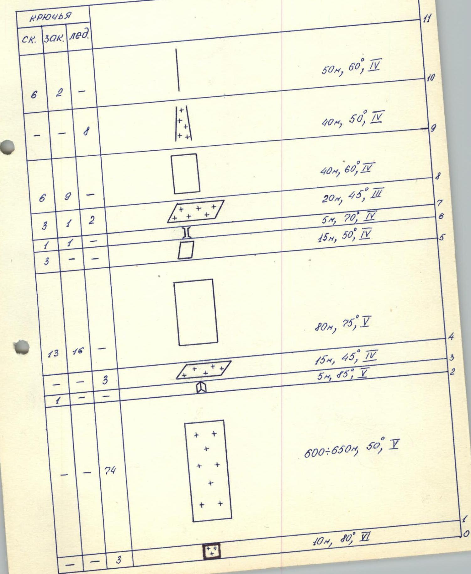
5. Height difference 950 m, length — 1020 m, length of sections with 5–6 difficulty category — 230 m. Average steepness of the ice part of the route 50°, rocky part — 65°.
6. Pitons hammered: rock — 62, chocks — 46, ice screws — 102.
7. Climbing hours — 16.5 hours.
8. Overnight stay — snow platform on the ridge.
9. Leader — Andryushkevich Konstantin Ivanovich, CMS. Participants — Panarin Nikolai Dmitrievich, CMS, Foigt Alexander Vadimovich, CMS, Chan-syan Anatoly Vladimirovich, CMS.
10. Coach — Zubarev Konstantin Mikhailovich.
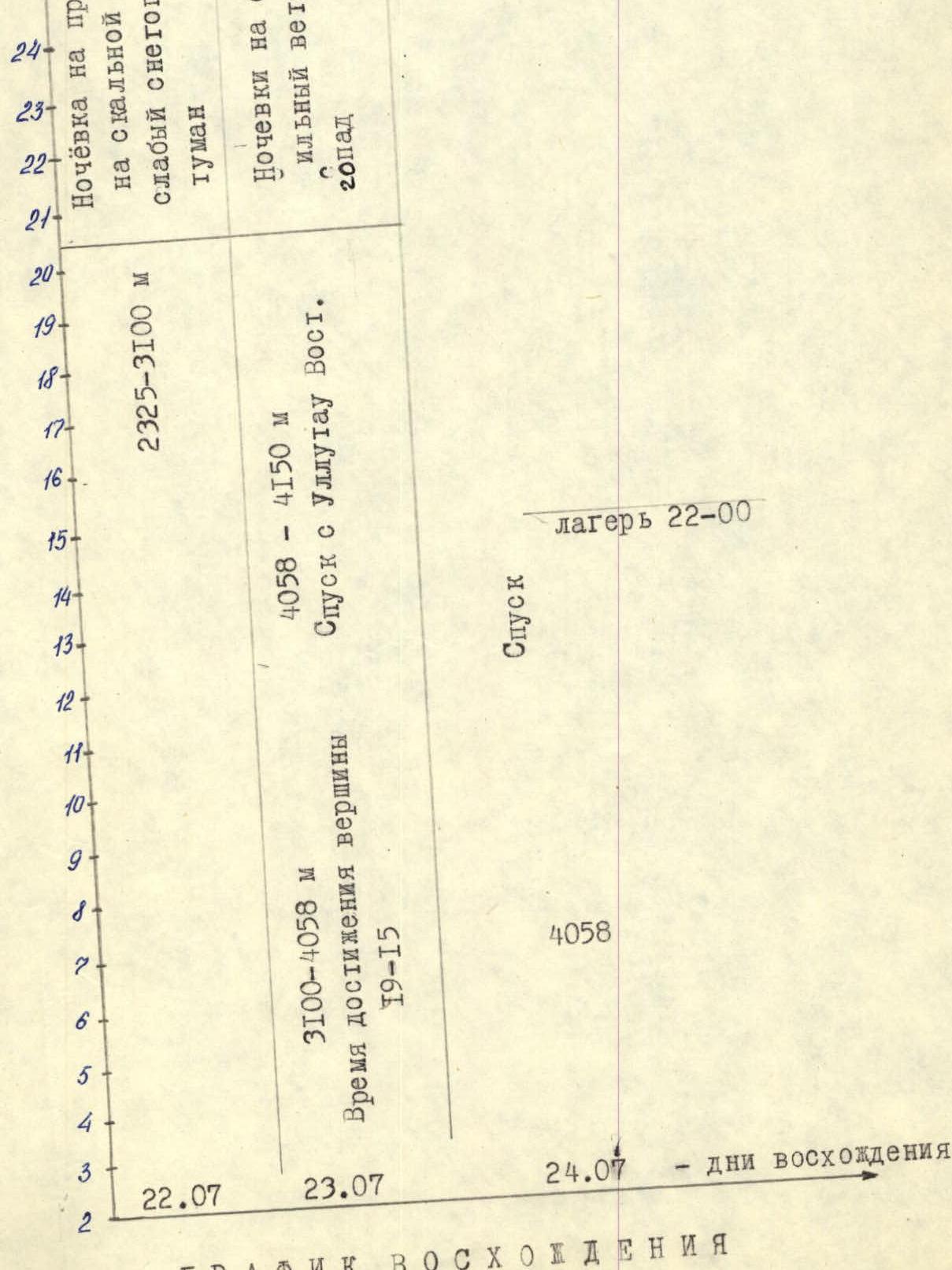
11. Approach to the route — July 22, 1985. Summit — July 23, 1985. Return — July 24, 1985.
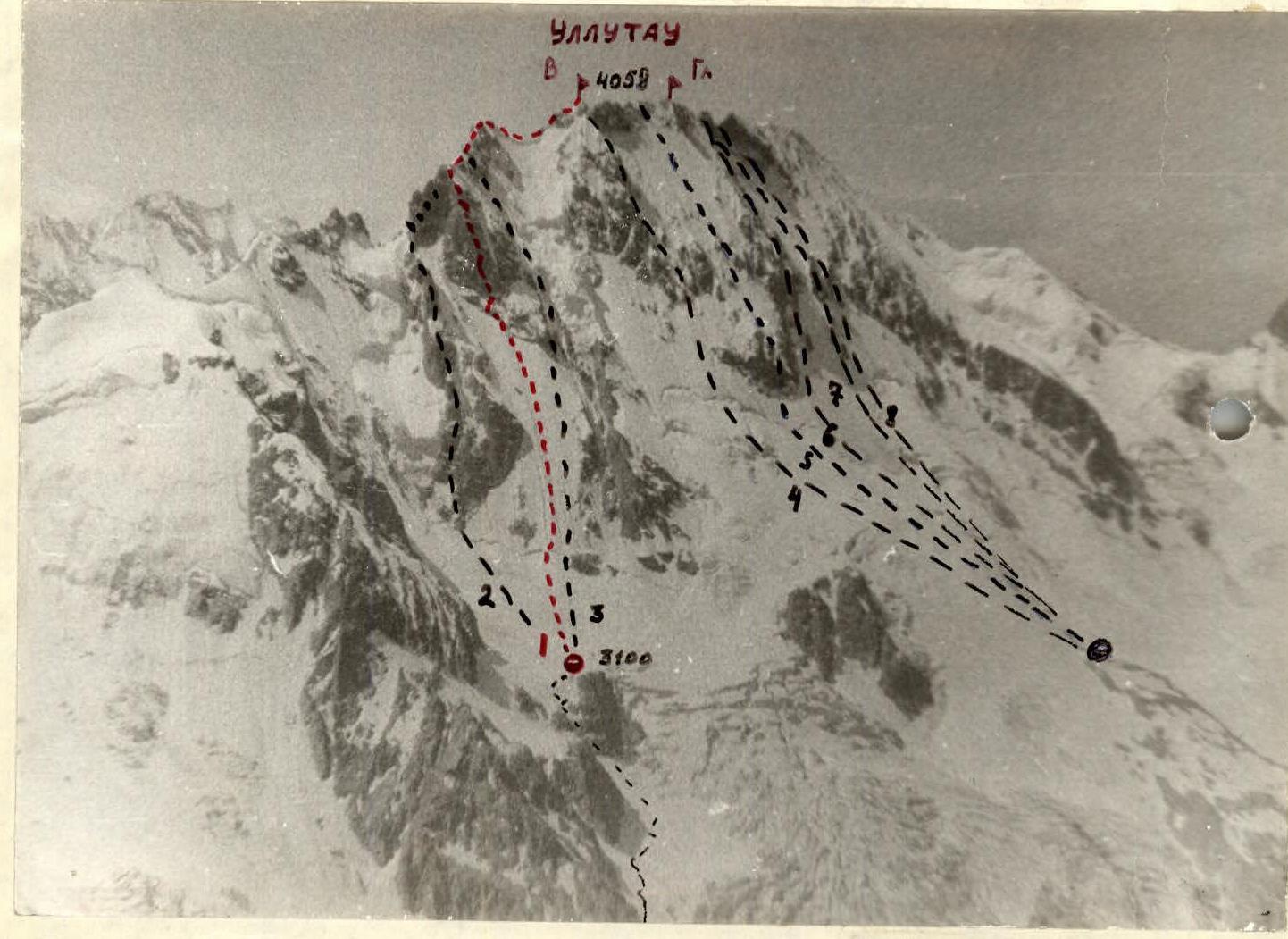
- Route climbed by the team: V. Ullutau via the N face of E shoulder (D. Chernoslivin – “red spot” 1959) 5B difficulty category.
- V. Ullutau via N face of E shoulder. 5B difficulty category. (A. Naumov 1966)
- V. Ullutau via right rib of N face of E shoulder. 5B difficulty category. (V. Artamonov 1979)
- V. Ullutau via right rib of N face. 5B difficulty category. (E. Manucharov 1954)
- V. Ullutau via rock “islands” of N face and W ridge. 5B difficulty category. (D. Chernoslvin 1965)
- Main Ullutau via N face. 5B difficulty category. (V. Abalakov 1951)
- Main Ullutau via rock “islands” of N face and W ridge. 5B difficulty category. (V. Maltsev 1971)
- Main Ullutau via NNW wall. 5B difficulty category. (V. Li 1982).
The team from Kemerovo region was formed based on competition results and completion of control standards. The team conducted a series of joint training sessions on challenging rocky and icy terrain throughout the spring of 1985. For the Championship, the judging panel selected routes on the Ullutau massif, and the team's route choice was based on their ranking in the “school”. The route via the North face of the eastern shoulder was climbed by D. Chernoslvin's group in 1959. This route is rarely attempted (once every 5 years) due to its complexity. When developing the tactical plan, the group received consultations from first-ascenders Ruzhevsky V.V. and Inotkin A.N., who completed the ascent in 1977. Since 1977, no teams had attempted this route. On July 22, from sunrise to noon, the group observed the route through a telescope. There were no rockfalls. Considering their high level of physical and technical preparation, a tactical plan was devised, предусматривающий прохождение маршрута с одной ночёвкой на спуске was created. The lower part of the route was decided to be climbed at night due to rockfall and avalanche risks. To ensure safety, movement on a double rope was planned.
Reliable radio communication and the presence of other groups in the area ensured the team's backup.
During the ascent, the tactical plan was largely executed.
Tactical actions of the group
The group started the route at 2:40 from Naumov's overnight bivouac. The lower ice part was climbed with the organization of belays. Teams Andryushkevich — Foigt and Panarin — Chan-syan alternated leading, evenly distributing the load. The first climber used an ice axe and ice screws. Ice screws were screwed in every 6–8 m. All participants climbed on a double rope. When moving on rocks, the first climber's load was distributed among team members, ensuring a fast and reliable ascent. Sections with icy rocks were climbed by the first climber wearing crampons.
At 18:00, the team reached the ridge. Movement was independent with alternating belays. At 19:15, the group reached the summit of V. Ullutau and set up an overnight bivouac on a snow platform on the ridge. The group's movement was complicated by bad weather.
On July 24, the group met the RSFSR-2 team, assessed the condition of the descent route, and decided to descend together to Mestia pass.
At 22:00, the team returned to the camp. According to the tactical plan, the return to camp was scheduled for 18:00. The 4-hour deviation from the tactical plan was due to:
- a sharp deterioration in weather conditions;
- complications during the rocky part of the route.
There were no accidents or injuries to participants.
Route diagram to UIAA scale. Scale 1:2000. Section R1–R2 Scale 1:10000.
Route description by sections
R0–R1 Bergschrund 10 m climbed using ice screws, belay through ice screws. Organization of belays. R1–R2 Snow-ice slope avg. 50° climbed wearing crampons. Organization of belays, belay through ice screws. R2–R3 Inner corner 5 m. Piton belay. Ice accretion. R3–R4 Ice ledge. Belay through ice screws, alternating. R4–R5 Rocky wall 80 m, broken rocks. Hazardous. Rocks are wet, organization of belays, piton belay. R5–R6 Steep smooth slabs covered with ice accretion. R6–R7 Icy chimney. R7–R8 Ledge with ice, belay through rock and ice pitons. R8–R9 Rocky wall 40 m, traverse to the right upwards with ice accretion. Piton belay. Rock is heavily broken. R9–R10 Ice couloir 40 m, traverse to the right upwards. R10–R11 Broken rocky ridge. Rocks are snowy. Piton belay. R11–R12 Ice couloir, traverse to the left upwards. Thin layer of wet ice. Belay through ice screws. R12–R13 Rocks of medium difficulty with snowy ledges. R13–R14 Traverse of a wet steep ledge. Challenging climbing. R14–R16 Steep broken rocks in snow above medium difficulty. R16–R18 Inner corner turning into a crack. R18–R19 Exit to the ridge via a buttress consisting of vertical blocks covered with snow. Ice accretion. Belay through ice screws and rock pitons. R19–R20 Movement along a rocky snowy ridge. Exit to the Eastern plateau. Simultaneous movement, belay through outcrops. R20–R21 Descent from the Eastern shoulder along a snowy ridge with cornices and ascent to the Eastern summit via smooth rocks. Simultaneous movement, belay through outcrops.