Ascent Passport
- Ascent class — rock.
- Ascent area — Main Caucasus Range from Chiperaza Pass to Kitlod Pass.
- Peak — Ullutau East (4058 m) via the right edge of the North face of the East shoulder.
- Proposed difficulty category — 5B.
- Route characteristics: height difference — 950 m, average steepness — 55°, length of sections: I difficulty grade — 0 m, II difficulty grade — 0 m, III difficulty grade — 640 m, IV difficulty grade — 80 m, V difficulty grade — 1290 m, VI difficulty grade — 0 m.
- Pitons driven for belaying: rock 39, ice 67, bolt —; for creating Intermediate Technical Objects (ITO): rock —, ice —, bolt —.
- Number of travel hours — 19 hours.
- Number of overnight stays — one in a tent on the pre-summit ridge.
- Team composition:
- Artamonov Alexey Vladimirovich — Candidate Master of Sports — team leader,
- Lyakhov Sergey Borisovich — 1st sports category,
- Ovchinnikov Mikhail Fedorovich — Master of Sports,
- Polyakov Gennady Fedorovich — Master of Sports.
- Team coach — Master of Sports Popov Viktor Pavlovich.
- Date of departure and return — August 5–8, 1979.
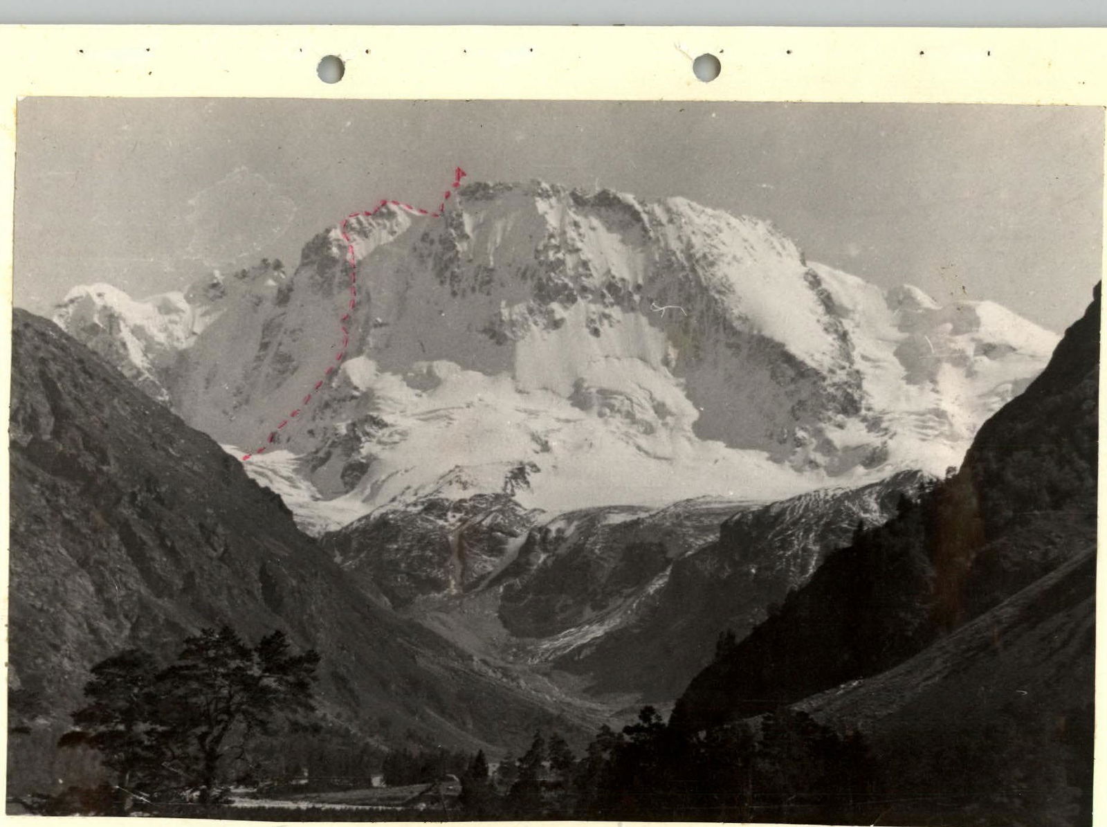 PHOTO 1. GENERAL VIEW OF ULLUTAU PEAK FROM ADYRSU VALLEY.
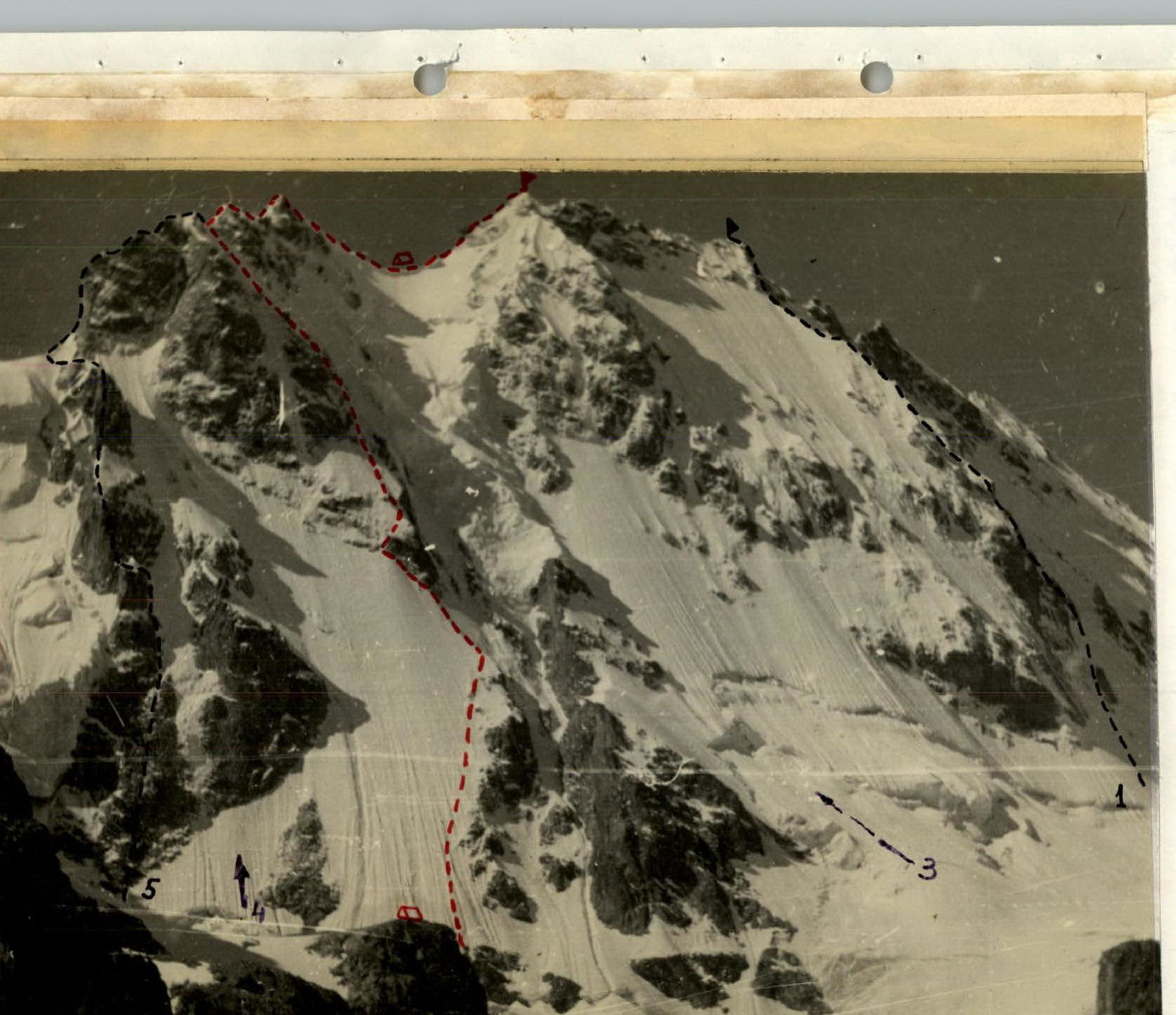 PHOTO 2. SEMI-PROFILE OF THE ROUTE. VIEW FROM GRANOVSKY GLACIER MORAINE (the first ascent route is marked in red, previously climbed routes are marked in black).
Brief Geographical and Alpinist Overview
The Ullutau peak (translated from Balkarian as "big mountain") is located in the Main Caucasus Range. Its massif, representing a sharp jagged ridge ~ 2.5 km long, stretched in a latitudinal direction, is bounded by Garvash and Mestia Passes. The northern slopes of the massif, closing the Adyrsu valley, break off with steep icy walls with a height difference of up to 1000 m to the eponymous glacier. The southern slopes of the peak are heavily destroyed and are not of alpinist interest. In the jagged ridge of the massif, Western (4203 m), Central (4207 m), and Eastern (4058 m) peaks are distinguished, having almost the same heights (in our assessment, the accepted height of the Eastern peak 4058 m is not correct, and it should probably be attributed to the Eastern sub-peak, the so-called "blade"). The small remoteness of the massif from the "Ullutau" and "Dzhailyk" camps, from which the peak and the ascent paths to it are perfectly visible, the complexity and beauty of its rock-ice walls contributed to the intensive development of complex routes to the peak. Almost all routes to the peak, laid along the wall part, are classified as 5B difficulty grade, only the ascent along the relatively gentle ice-snow "board" is awarded 5A difficulty grade. Currently, the following wall routes to the peaks of the massif are classified:
- Ullutau (Main peak) via N wall — 5B combined.
- Ullutau (Main peak) via rock islands of N wall — 5B combined.
- Ullutau (E peak) via counterfort of N wall — 5B combined.
- Ullutau (E peak) via NE wall through shoulder — 5B combined.
- Ullutau (E peak) via N bastions of shoulder — 5B combined.
- Ullutau (E peak) via N wall, left of counterfort of Main peak — 5B combined.
- Ullutau traverse with ascent via NW "board" to W peak — 5A combined.
- Ullutau (W peak) via N wall (via "rake") — 5B combined.
More than once, the Ullutau walls became prize-winners at national alpinism championships. So, in 1951, V. Abalakov's team was awarded gold medals in the class of technical ascents for ascending the Central peak via the northwest wall. The same route the following year brought the "Khimik" team under the leadership of E. Manucharov third place. In 1954, the "Khimik" team under the leadership of the same E. Manucharov received silver medals for passing the route to the Eastern peak via the north wall. Routes to Ullutau until recently were among those counted for passing in a duo. Nevertheless, despite such an abundance of complex routes to the peak, the large extent of the massif provided opportunities for further creative search and solving emerging problems. More on this in the following paragraphs.
Ascent Preparation
Choosing an ascent object for participation in the Moscow city alpinism championship, team members, on the advice of coach V. P. Popov, drew attention to the right part of the North wall of the East shoulder of Ullutau peak. In the lower third, the right part of the wall represents a vaguely expressed rock edge, turning into a steep ice knife, wedged into steep icy rock walls. To the right is a gully, through which ice avalanches from the tongue of the hanging glacier, descending from the saddle between the East shoulder and the Eastern peak, periodically thunder. To the left is a steep ice board, cut by gullies of avalanches with traces of rockfalls from the upper part of the wall. The activity of the wall in terms of avalanches and rockfalls and frequent ice collapses, which we observed during the previous ascent to the E peak via the left part of the wall (via Bastions of the East shoulder) in the summer of 1976, required careful study of the proposed route and thorough preparation of the tactical ascent plan. Life on Mestia overnight stays (directly under the route) during instructor work with participants in the 2nd and 3rd shifts made it possible to study the wall's regime and route details well and draw the following conclusions:
- During bad weather, thaw, and solar exposure, the upper part of the wall — part of the route — below the ice knife is shot through with rockfalls and avalanches from the upper destroyed part of the wall and ice slope.
- The knife is relatively safe but can be blocked in case of a large ice collapse from the tongue of the hanging glacier.
- The route is uniformly steep; organizing a convenient bivouac with tent setup is problematic. There seems to be a place for a tent only after the "finger" on the snow ridge in the upper part of the wall.
- Due to intensive snowmelt due to spring "brown" snowfall and rainy inclement weather, ice prevails on the route. The rocks of the upper part of the wall are destroyed and covered with rime ice.
- The lower part of the tongue of the hanging glacier looks calm.
In accordance with the given nature of the route, a tactical plan for the assault was chosen, providing for:
- early — nighttime ascent to the route in frosty weather,
- quick passage of the lower, "shot-through" part,
- possible overnight stays in the area of the "finger" and on the snow ridge under the "blade".
Before heading out on the route, team members worked as instructors for 2 shifts in the "Dzhailyk" campsite, went through a cycle of rock and snow-ice training, and completed ascents on routes of 5A–5B difficulty grade.
Route Description to Ullutau East peak via the right edge of the North wall of the East shoulder 5B difficulty grade.
From the "Dzhailyk" campsite along the Mestia trail. At the Mestia overnight stays — crossing the Adyrsu river and ascent along the ridge of the right (orogr.) moraine of the glacier descending from under the North wall of the East shoulder of the peak. Ascent along the glacier to the right "hitzan" (rocky outcrop), where the initial overnight stays are. (Approach time ~ 3.5 hours). From the overnight stays through the glacier, bypassing crevices — approach to the start of the route. The beginning of the route — under the rock island of the base of the right edge of the North wall of the East shoulder, separated from the counterfort of the Eastern peak of Ullutau by a deep gully, through which avalanches and ice collapses from the hanging glacier descending from the saddle between the sub-peak of the E peak and the E peak, descend.
Hazards:
- Large ice collapses can sometimes block the lower part of the route (sections R1 and R2).
- In warm weather, after snowfalls, and during solar exposure of the route, the lower part (sections R1–R3) is subject to rockfalls and avalanches from the upper destroyed walls of the East shoulder.
Therefore, it is recommended to start the route on a clear frosty night no later than 2 hours.
Section R1. The bergschrund is overcome from the left along the rock island, first along avalanche cones and bridges, then along an ice wall with flowing water (10 m, 70°), with an exit to the ice slope above the rock island.
Section R2. Movement along the ice slope to the right and up, leaving the rock islands of the edge to the right, initially along snow strips, crossing ice gullies (120 m, 45°), then along ice with increasing steepness to 55° to the base of the snow-ice knife (~ 400 m). Further movement along the knife:
- first along snow ~ 30 m;
- then 80 m along ice with a steepness of up to 60° under the rock island.
Section R3. The rock island is bypassed to the left along ice along the edge of the rocks (ice steepness ~ 60°, length — ~ 60 m). Exit to the rock island:
- first along a frozen waterfall (~ 10 m, 80°);
- then along a heavily destroyed internal angle, covered with rime ice (dangerous, stones!!!), with a steepness of ~ 70° (30 m), then flattening to 55°;
- exit to an indistinctly expressed ice ridge.
Section R4. Along the ridge (~ 60 m, 55°), approach under the rock wall (7 m, 80°), after which an ice slope with protruding stones begins. Movement along the slope:
- straight up (40 m, 55°);
- then traverse to the right and up (40 m), a narrow ice gully, on the approach to which the steepness increases to 65°;
- along the gully with stones frozen in ice;
- exit to a snow ridge (20 m, 60°).
Here, for the first time on the route, it is possible to cut out two platforms one above the other, where two people can stand to rest. To the left and 10 m above the beginning of the ridge is a control tur in a bank on a piton.
Section R5. From the tur, 40 m straight up along the ridge, first along snow, then along ice with a steepness of ~ 60° under the destroyed rock walls. Bypass the walls to the right along the ice slope adjacent to the hanging glacier (40 m, 60°) to the first rock-ice gully, leading left and up to the ridge.
Section R6. From the base of the gully, the path goes left and up to the destroyed rock ridge with a snow "knife" (20 m, 70°), 10 m along the "knife", and again cross left and up under the rocks to the next ice gully. From here, ascent along the destroyed internal angle with a plug in the upper part (20 m, 80°) and exit to the snow-ice slope, along which the approach is made under the "finger". Bypass the "finger":
- Bypass to the right, traversing under the overhanging walls of the rock-ice slope with a steepness of up to 70°;
- Exit to a snow knife;
- Here, if you work hard, you can make a platform for setting up a tent.
Section R7. The snow knife turns into a ridge, along which the ascent goes straight up (40 m, 45°). Then, moving left and up along a steep (~ 65°) ice slope covered with a thin layer of thawed snow, with outcrops of destroyed rocks (belaying via rock and ice pitons), exit to the saddle of the East ridge (120 m, 65°) — cornices are possible.
Section R8. Along the ridge, traversing straight into two seracs, we ascend to the Eastern sub-peak — the "blade". From the "blade":
- descent to the snow saddle of the ridge;
- ascent to the Eastern peak.
Descent. Along the ridge, descent to the place of exit from the wall part of the route to the East ridge. Further to the right to the destroyed rock ridge, along which the descent is ~ 120 m to the destroyed internal angle going to the right, along which the descent is down ~ 80 m to the scree shelves. Traversing along the scree shelves to the left and down, we exit to a shelf under the wall of the East ridge, traversing along which we exit under the "cucumbers". Bypassing the "cucumbers" to the right, we exit to the East ridge, along which we descend to simple scree shelves leading to the right from the ridge to the Mestia plateau. From the plateau, ascent to the Mestia Pass, from which descent to the "hut" and onto the trail.
Ascent Diary
August 5, 1979, at 6:00, the team consisting of: Artamonov A. V. — Candidate Master of Sports — team leader, Lyakhov S. B. — 1st sports category, Ovchinnikov M. F. — Master of Sports, Polyakov G. F. — Master of Sports — left the "Dzhailyk" campsite. In good tempo, they crossed the river at the Mestia overnight stays and after 3.5 hours reached the initial bivouac on the right "Hitzan" under the N wall of the E shoulder. After setting up the tent, they began to prepare to accumulate more calories and observe the route, especially the path of overcoming the bergschrund. In the morning, the weather is normal, variable cloudiness, but by 12:00, following the standard schedule of the current summer season, it became overcast, rain started, and it became gray and gloomy. In the evening, a strong thunderstorm passed, but did not improve the weather. From the wall, the rustling of wet snow avalanches was periodically heard…
August 6, 1979. 0:20 — silence in the "yard", not a single star in the sky. The wall is quiet so far. Warm. We discuss what to do, although the inner voice gently but insistently invites us to sleep more. Still, the captain gets dressed and goes out to trample and feel the snow… No, it's warm. The snow is very wet… And everyone, with relief and pleasure, under the measured beat of the starting rain, returns to unfinished dreams…
5:00. It's light, it's getting colder. Somewhere in the gaps, the blue sky is visible, the weather is clearly improving. The Artamonov — Ovchinnikov team heads under the wall to scout out the passage of the bergschrund and exit to the ice slope. The "brand" ice equipment (ice hammers and 14-tooth crampons) allows them to quickly overcome the bergschrund along a snow bridge and a ten-meter ice wall ~ 70°, along which, despite the early hour, a stream of water flows, and exit to the beginning of the ice slope. The path further is clear, and the team quickly descends back to the bivouac. Meanwhile, by turning over stones on the bivouac, Polyakov discovered delicacies — 3 cans of liver pate from last year's delivery, and experienced cook S. B. Lyakhov immediately processed the pate and prepared an excellent breakfast. The morning sun illuminated the wall, and immediately stones started falling from somewhere from the upper part, which, sliding down the ice slope, blocked the initial section of the route. Clear sunny weather, detailed discussion of all sections of the route determined the team's decisive combat mood, and everyone unanimously confirmed the planned plan — we leave tomorrow at 1:00 AM.
August 7, 1979. Departed at 1:00. Cold. After 30 minutes, we cross the glacier and begin the ascent. The Artamonov — Lyakhov team leads, the 2nd team Ovchinnikov — Polyakov follows. We move alternately with autonomous teams, periodically transferring pitons to the leader of the 1st team. On the lower part of the ice slope above the bergschrund, between ice gullies, there is a layer of snow frozen overnight, along which we ascend ~ 3 ropes, periodically crossing to the right ice gullies. Belaying is done through screw ice pitons, as the snow layer is quite thin. Further, the steepness of the ice increases to 55°, but the pace of movement remains quite high. After the 13th rope, we exit to the ice knife, on the lower part of which a small layer of snow still remains, on which in two places there are oblique furrows — traces of an ice collapse from the tongue of the hanging glacier. The ice knife steeply rises under the rock island (~ 3 ropes with a steepness of up to 60°). The bypass of the island to the left along ice along the boundary of destroyed rocks leads to a frozen waterfall. To the left of the waterfall, the rocks are covered with a thick layer of rime ice, and it's not attractive there. To the right, everything is heavily destroyed and overhangs. Ascent along the waterfall (belaying with pitons with slings to the right into the wall), then along the destroyed, barely held together by rime ice, internal angle to the top of the rock island. 18 ropes have been passed. The last one is a fixed rope. We climb up it, and now the leader of the second team — Ovchinnikov — moves forward. Time is 7:30. At 8:00, we check in — everything is fine. More ice, rocks covered with ice, ice… The steepness is still increasing… After 5 ropes, we exit to a small ridge. For the first time, we can rest. We cut out two platforms one above the other, where we can stand in pairs, and prepare tea and snacks. To the left and ~ 5 m above the base of the ridge, we drive a piton into a thin crack of the overhanging wall and hang a bank with a note on it (as it later turned out, this extremely valuable piton was marked "made in USA" and was a gift to M. Ovchinnikov from American climbers during joint ascents in the Pamir in the summer of 1976). Having linked up with the camp at 10:00 and had a snack, we continue moving. We move team by team, alternately led by Ovchinnikov and Artamonov, armed with ice hammers and special crampons. The nature of the route remains the same: ice, destroyed steep rock walls covered with rime ice, but movement becomes more complicated and dangerous due to the fact that here, in the upper part of the wall, there is a layer of 5–10 cm of snow on the ice, which is getting wetter by the minute, "tears" appear on rocks and rime ice, and stones frozen in ice begin to thaw under the bright sun. By the 14:00 check-in, we exit to a snow knife behind the "finger" on the ridge of the upper rock island. The snow knife is very sharp and narrow. To make a platform here, you need to have architectural data and high work capacity. Along the thawing steep snow-ice ridge, and then slope with outcrops of rocks, we move left and up to the depression in the E ridge of the E sub-peak ("blade"). Time is 16:45. 33 ropes have been passed. We move along the ridge to the snow saddle between the "blade" and the E peak, and here, by 18:00, we stop for the night. The weather is deteriorating. Wind from Svaneti periodically brings charges of snow grains…
August 8, 1979. Morning. Visibility is "zero". The entire tent is covered with frost. In strong winds, beautiful ice flags have grown on the guy lines. We pack our backpacks and at 8:00 head to the E peak. On the peak at 8:40. Strong wind, nothing is visible, fog. We are in the clouds. At 9:00, we begin the descent along the E ridge. The descent is familiar from previous ascents. Under the "cucumbers", we exit the cloud layer, and by 16:00 descend to the Mestia overnight stays, where we start devouring the remaining food supplies… And in the camp, we are greeted with a warm welcome, congratulations, and a great bath.
Conclusion
The first ascent route is individual and does not repeat previously climbed routes in the wall part (the path along the ridge of the East shoulder of the peak, as well as for routes 4 and 5, passes along part of the 3B category route). The route is logical and does not allow for simpler ascent options. The ascent requires a team to have good tactical preparation and a high level of ice climbing technique. It is desirable to use special crampons and ice hammers (team members who went in standard crampons passed the entire route second in the team). According to team members who previously climbed the route to the Main peak of Ullutau via rock islands of the North wall of 5B category (the most suitable for comparison in terms of its nature), the proposed route is not inferior in difficulty and has a more intense character.
Table of Main Characteristics of the Ascent Route
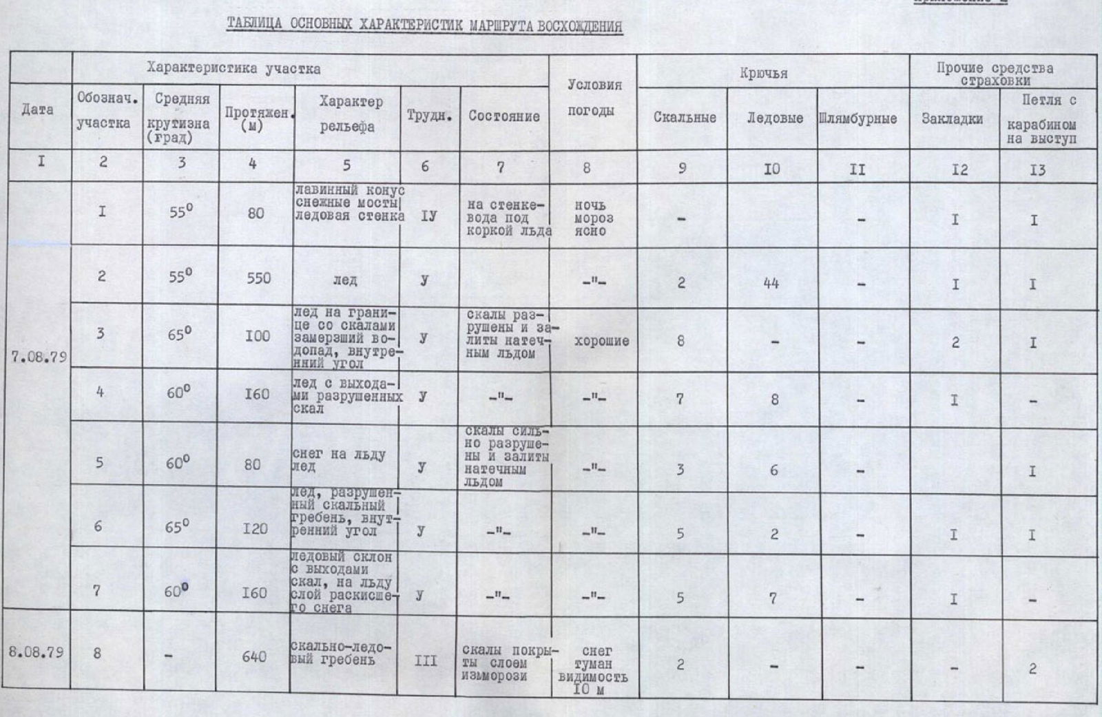
| Date | Section Label | Average Steepness (degrees) | Length (m) | Terrain Character | Difficulty | Condition | Weather Conditions | Rock Pitons | Ice Pitons | Bolt Pitons | Other Slings | Other Loop with Carabiner on Outcrop |
|---|---|---|---|---|---|---|---|---|---|---|---|---|
| R1 | 55° | 80 | Avalanche cone, snow bridges, ice wall | 4 | On the wall — water under the ice crust | Night, frost, clear | - | - | - | 1 | 1 | |
| August 7, 1979 | R2 | 55° | 550 | Ice | 5 | - | - | 2 | 44 | - | 1 | 1 |
| R3 | 65° | 100 | Ice on the boundary with rocks, frozen waterfall, internal angle | 5 | Rocks are destroyed and covered with rime ice | Good | 8 | - | - | 2 | 1 | |
| R4 | 60° | 160 | Ice with outcrops of destroyed rocks | 5 | - | - | 7 | 8 | - | 1 | - | |
| R5 | 60° | 80 | Snow on ice, ice | 5 | Rocks are heavily destroyed and covered with rime ice | - | 3 | 6 | - | - | 1 | |
| R6 | 65° | 120 | Ice, destroyed rock ridge, internal angle | 5 | - | - | 5 | 2 | - | 1 | 1 | |
| R7 | 60° | 160 | Ice slope with outcrops of rocks, on ice a layer of thawed snow | 5 | - | - | 5 | 7 | - | 1 | - | |
| August 8, 1979 | R8 | - | 640 | Rock-ice ridge | 3 | Rocks are covered with a layer of frost | Snow, fog, visibility 10 m | 2 | - | - | - | 2 |