Ascent Passport
- Ascent class — technical.
- Ascent area — Central Caucasus.
- Object of ascent — Tyu-Tyu 2nd Western (4420 m) via the North wall.
- Height difference of the wall part of the route — 1400 m. Total route length — 1765 m. Length of sections with 6th cat. diff. — 215 m. Length of sections with 5th cat. diff. — 335 m.
- Average steepness of the wall part of the route — 65°.
- Pitons driven: rock — 19, ice — 48, bolt — 0, chocks — 133.
- Number of climbing hours — 21, days — 2.
- Number of bivouacs on the route — 1 (comfortable, lying down).
- Water availability — snow throughout the entire route.
- Team leader — Kadoshnikov N.G., CMS.
Team members:
- Yudin A.N., CMS
- Chepur A.A., MS
- Kravchenko O.V., CMS.
- Team coach — Gorbachevsky A.D.
- Departure to the route — August 1, 1996. Reaching the summit of Tyu-Tyu 2nd Western — August 2, 1996. Return to the base camp — August 2, 1996.
- Ascent organized by the Krasnodar Committee for Physical Culture and Sports team.
Route scheme in UIAA symbols
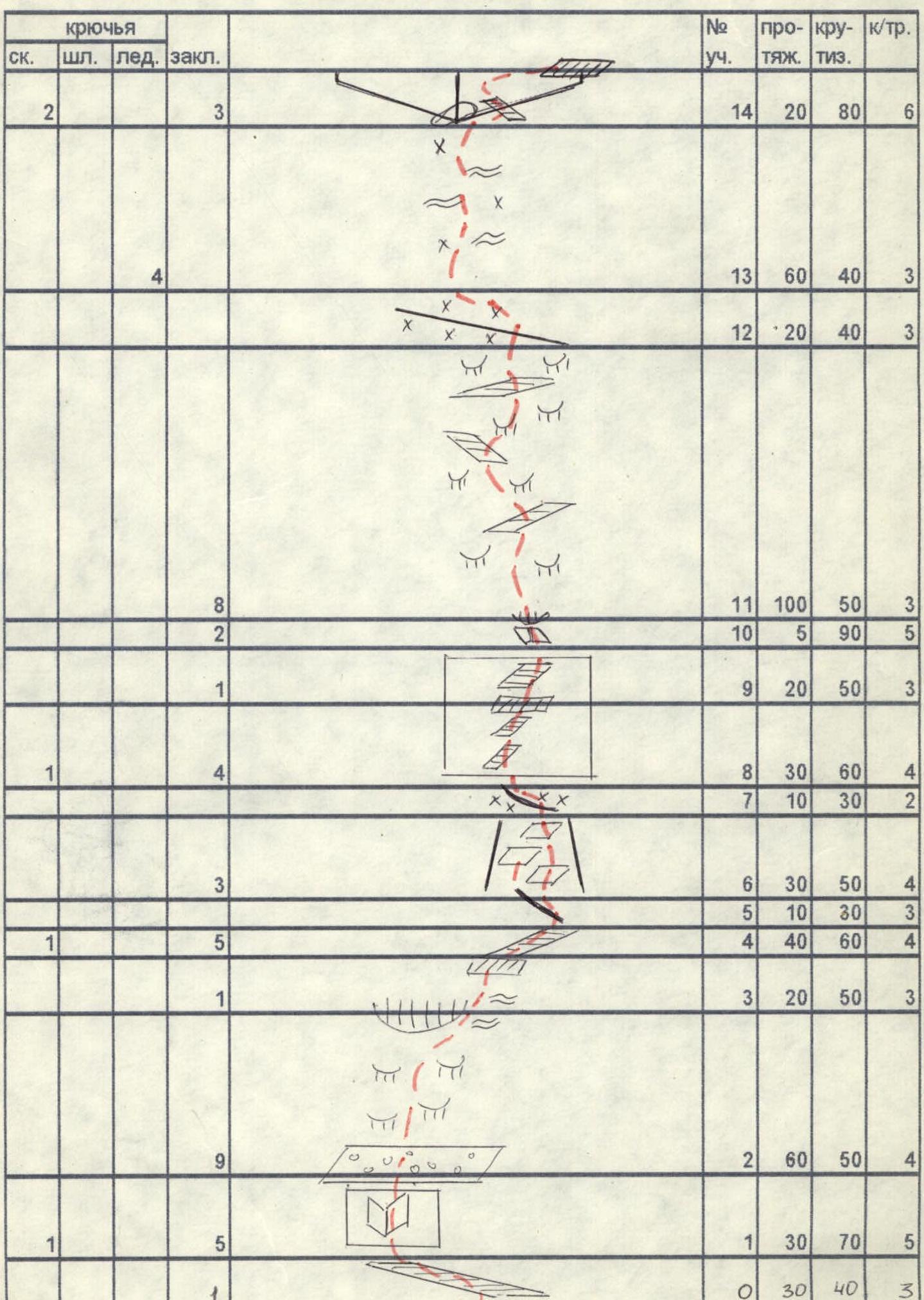
| № sect. | rock | bolt | ice | chock | length | steepness | cat. diff. |
|---|---|---|---|---|---|---|---|
| 39 | |||||||
| 38 | 2 | 80 | 40 | 3 | |||
| 37 | 4 | 50 | 40 | 4 | |||
| 36 | 4 | 20 | 80 | 5 | |||
| 35 | 1 | 1 | 40 | 40 | 3 | ||
| 34 | 2 | 15 | 70 | 4 | |||
| 33 | 18 | 180 | 40 | 3 | |||
| 32 | 2 | 5 | 80 | 6 | |||
| 31 | 2 | 10 | 50 | 3 | |||
| 30 | 12 | 120 | 45 | 4 | |||
| 29 | 4 | 30 | 60 | 4 | |||
| 28 | 2 | 2 | 30 | 75 | 5 | ||
| 27 | 8 | 140 | 40 | 3 | |||
| 26 | 3 | 12 | 90 | 80 | 6 | ||
| 25 | 1 | 4 | 40 | 80 | 6 | ||
| 24 | 10 | 50 | 70 | 5 | |||
| 23 | 30 | 30 | 3 | ||||
| 22 | 2 | 30 | 40 | 4 | |||
| 21 | 5 | 50 | 50 | 4–5 | |||
| 20 | 1 | 3 | 30 | 70 | 5 | ||
| 19 | 2 | 30 | 40 | 3 | |||
| 18 | 2 | 10 | 50 | 4 | |||
| 17 | 3 | 14 | 60 | 80 | 6 | ||
| 16 | 3 | 20 | 60 | 4 | |||
| 15 | 3 | 17 | 120 | 70 | 5 | ||
| 14 | 2 | 3 | 20 | 80 | 6 | ||
| 13 | 4 | 60 | 40 | 3 | |||
| 12 | 20 | 40 | 3 | ||||
| 11 | 8 | 100 | 50 | 3 | |||
| 10 | 2 | 5 | 90 | 5 | |||
| 9 | 1 | 20 | 50 | 3 | |||
| 8 | 1 | 4 | 30 | 60 | 4 | ||
| 7 | 3 | 10 | 30 | 2 | |||
| 6 | 1 | 30 | 50 | 4 | |||
| 5 | 1 | 5 | 10 | 30 | 3 | ||
| 4 | 1 | 40 | 60 | 4 | |||
| 3 | 9 | 20 | 50 | 3 | |||
| 2 | 1 | 5 | 60 | 50 | 4 | ||
| 1 | 1 | 30 | 70 | 5 | |||
| 0 | 30 | 40 | 3 |
Route description by sections
R0–R1 — Sloping shelf leading to under the Red wall. R1–R2 — Smooth inner corner leading to a terrace with rocks. R2–R3 — Rocks, like "ram's foreheads", leading to under an overhanging rock. R3–R4 — Bypassing the rock along the edge of ice and rocks. R4–R6 — Along the shelf to a rocky shoulder. R6–R7 — Up a slab-like couloir to a snow bridge. R8–R11 — Along the shelves of the wall under an overhanging little wall and through it to rocks like "ram's foreheads". R11–R12 — Across the rocks to a snowy shoulder. R12–R14 — Across snow and ice to the base of a large inner corner. R14–R18 — Keeping to the right side of the inner corner, to a small site above the corner. R18–R20 — From the site along a rocky-ice slope to the left of overhanging rocks under the wall. R20–R21 — Steep wall with an exit to a site. R21–R24 — Along an indistinctly expressed ridge under a tower and bypassing it on the right via a couloir. R24–R26 — From the tower via large-block rocks and an inner corner, exit to the ridge. R26–R29 — Along a steep rocky ridge turning into an ice ridge, to a couloir and via it exit to a site and further along the ridge under the Red wall. R30–R31 — Bypassing the wall on the right via ice and snow, to a rocky tower. R31–R33 — Exit to the tower on the left. R33–R34 — Along a rocky-ice ridge under a rocky ascent. R34–R35 — Traverse to the left and via a cleft, ascent to a shelf. R35–R37 — Along the shelf to the right upwards and via an inner corner, exit to an ice slope. R37–R39 — Along the ice slope to the rocks of the ridge and via them, exit to the summit.
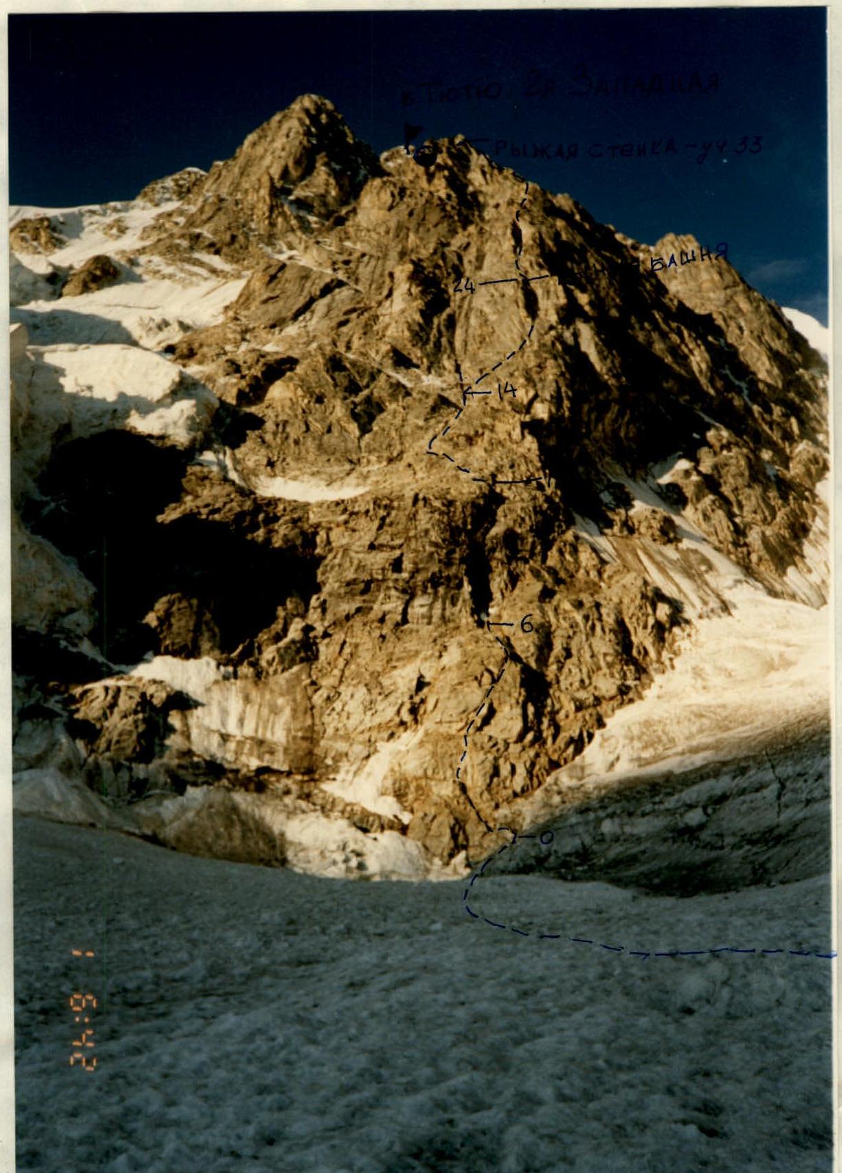
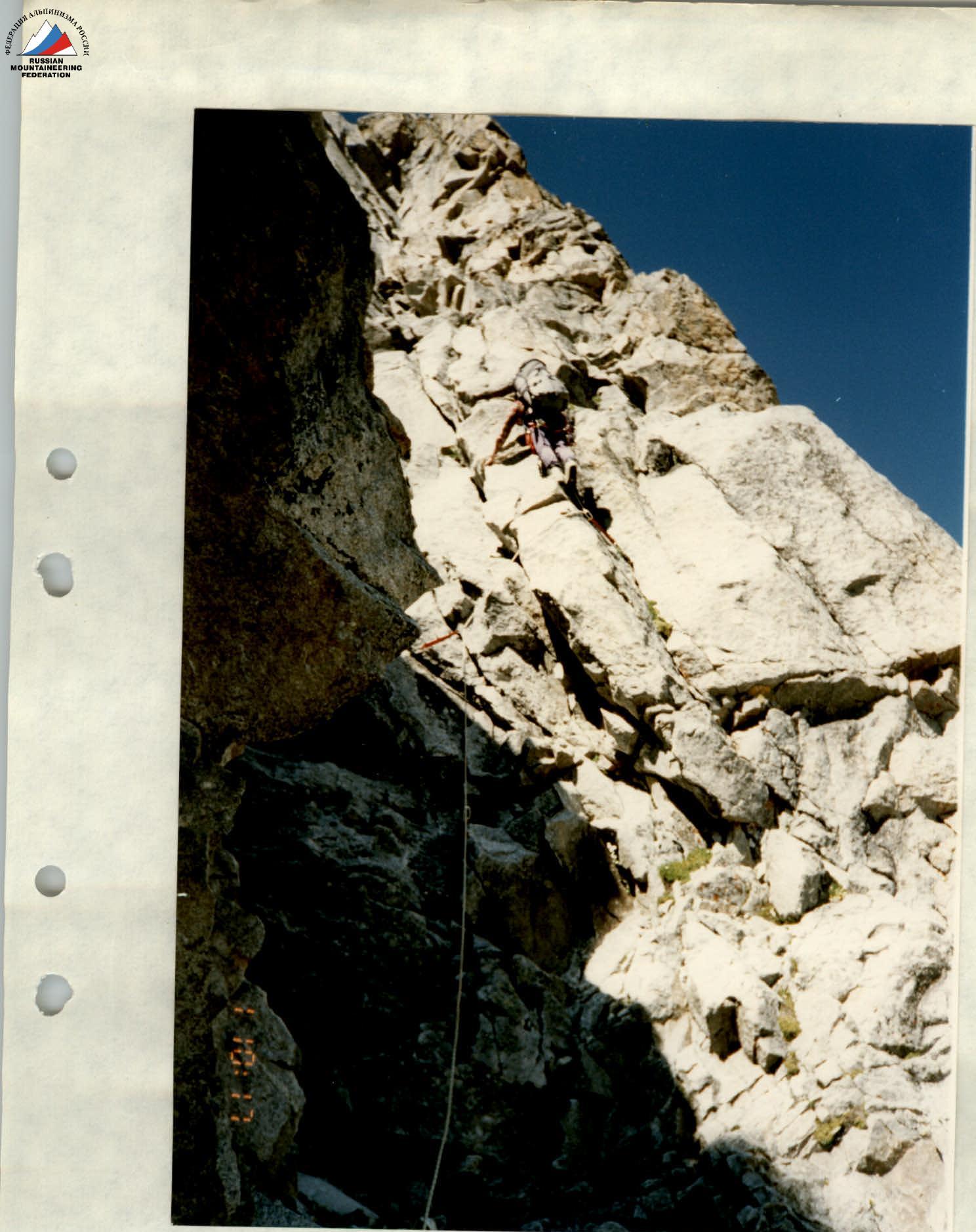
Technical photograph. Photo №2
Passage of the first section R15–R16. Photo №3
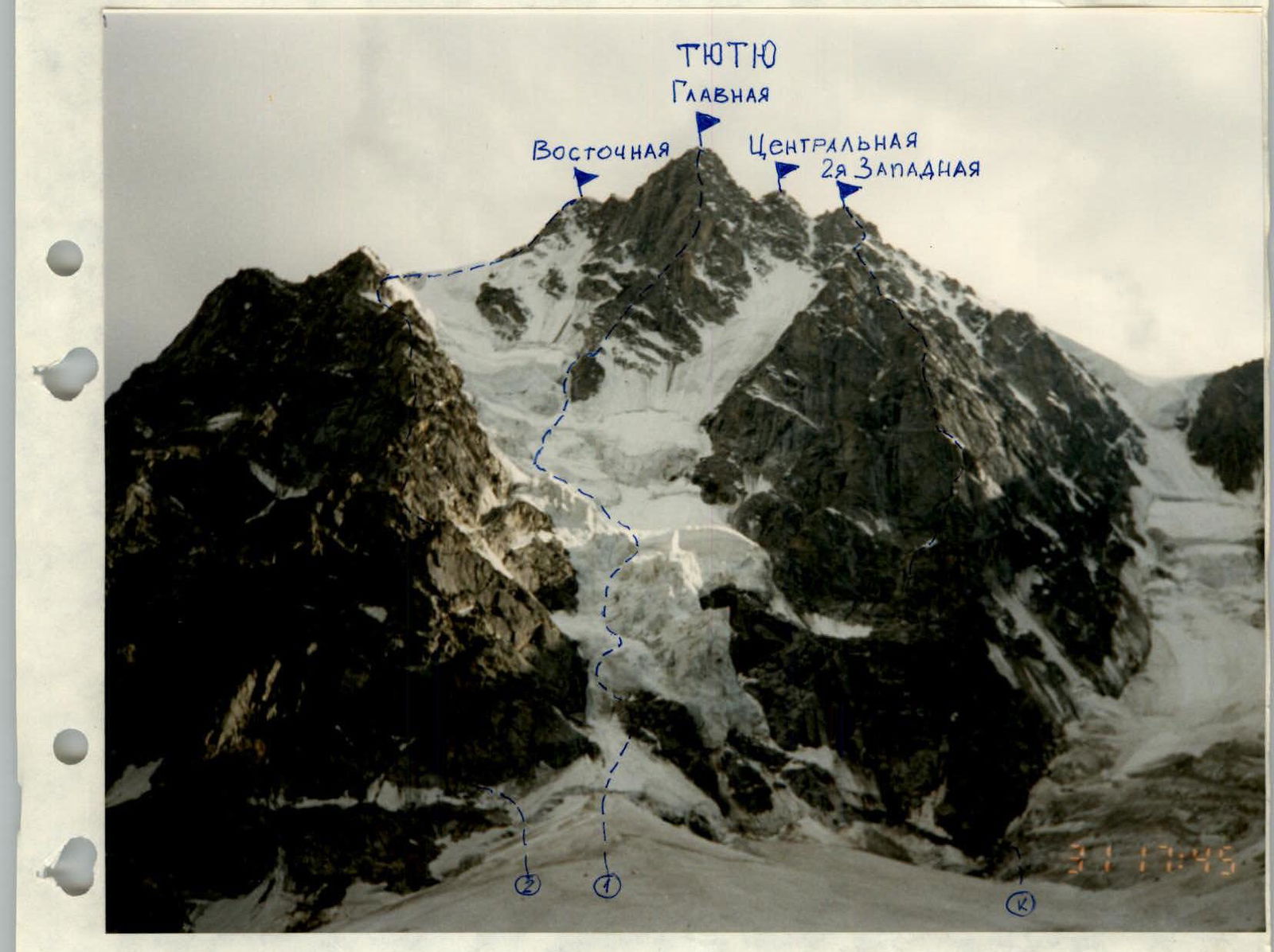
K — M. Khergiani route — 2nd Western via N wall, 6A.
- — I. Kakhiani route — Main via N edge, 5B.
- — L. Popov route — Eastern via N wall, 5B. General view of Tyu-Tyu peak. Photo №1.