Climbing Passport
Appendix I
- Climbing type — rock.
- Climbing area: spurs of the main Caucasian ridge from Chiperazau pass to Kitlod pass.
- Peak, its height and ascent route: Termen-bashi — 4050 m via the northern counterfort.
- Expected difficulty category — 3–4B.
- Route characteristics: height difference — 500 m average steepness — 50° length of sections: category I — 300 m category II — 400–440 m category III — 300–320 m category IV — 60–70 m
- Pitons hammered
| for belay | for creating I.T.O. | |
|---|---|---|
| rock | 14 | - |
| ice | 0 | |
| bolt | 0 | - |
- Number of travel hours — 6 hours.
- Number of overnight stays and their characteristics — none.
- Surname, name and patronymic of the leader and participants, their sports qualification:
- RYZHIKOV SERGEY ANATOLʹEVICH — CMS — leader.
- KONOVALOV VLADIMIR — CMS.
- BAGLEY LARISA GRIGORʹEVNA — CMS.
- YAKIMCHUK VL-R PESTNIK — 13/7-777.
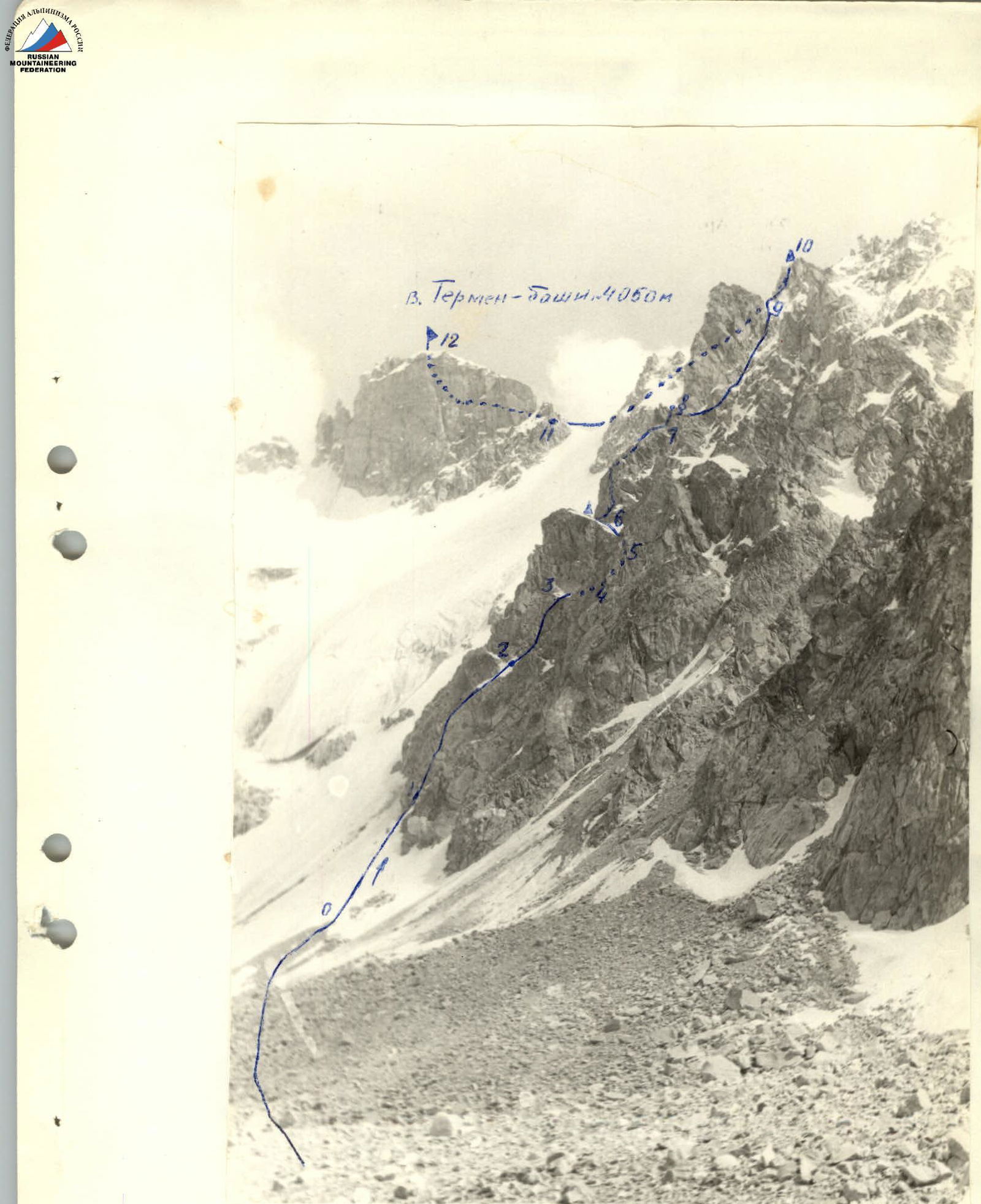 2. General view of the route from l. 10–3 Sullukol.
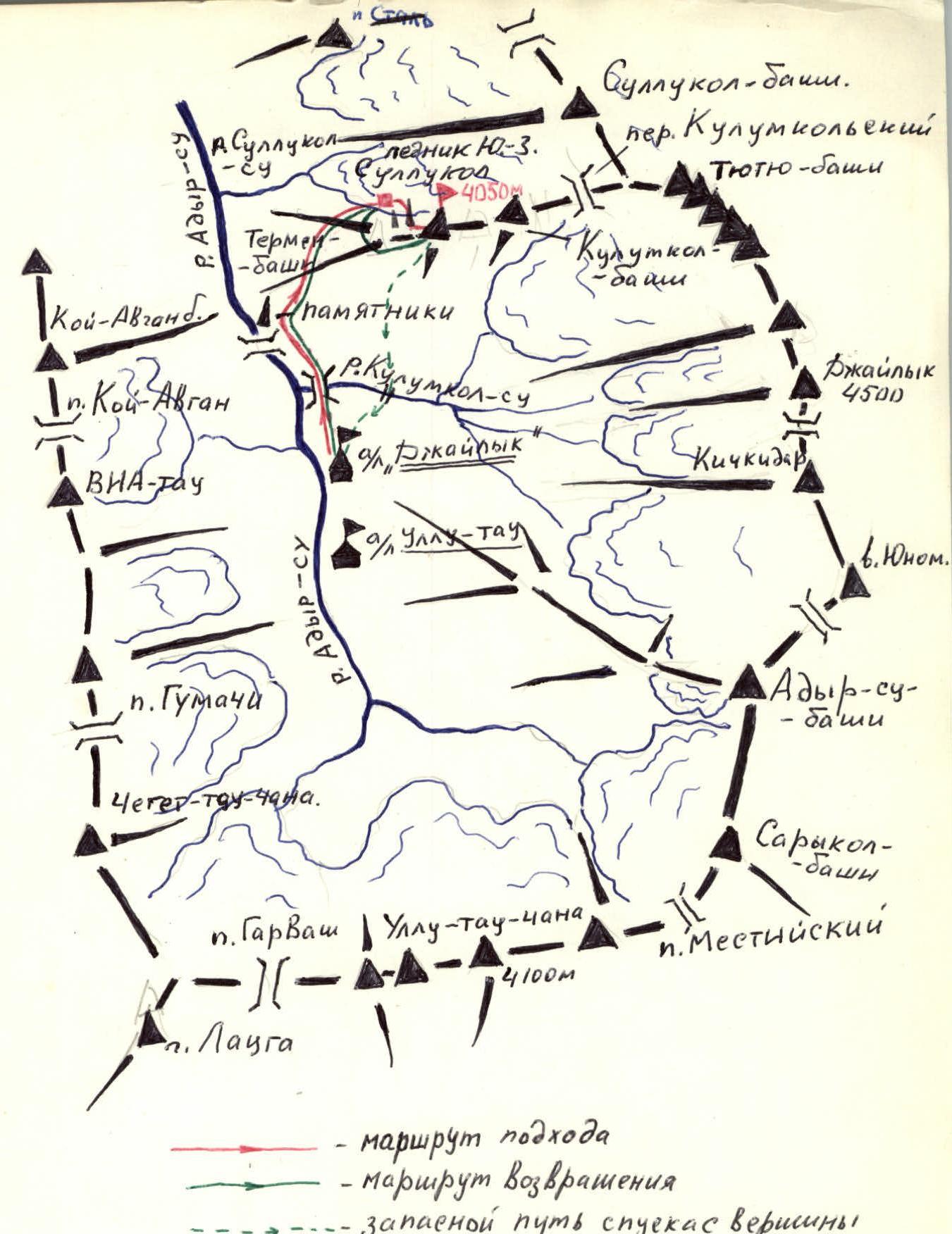
Climbing Area
The Termen-bashi peak — 4050 m is located in the Adyr-su gorge area, in a spur of the main Caucasian ridge, which is the watershed of the Adyr-su and Tyutyu-su rivers.
The massif starts with the peak of the Greater Caucasus Range Sarykol and includes the peaks Adyr-su, Yukom, Kichkidar, Dzhailyk, Tyutyu-bashi Sullukol. In its lateral branch between the peaks Sullukol and Tyutyu-bashi is located the peak Termen-bashi. The peak is mainly composed of granites. The Sullukol area is the least developed in mountaineering terms of all the lateral branches of the Adyr-su gorge. At the same time, it has a number of advantages, which include:
- the presence of a significant number of technical, rock routes of 3–4 categories (4–5 pieces)
- the possibility of making ascents with one overnight stay
- a milder microclimate
In this regard, its mountaineering development is expedient.
Route Description
Approach to the Route
- From the Dzhailyk alpine camp, go down the road along the Adyr-su river to the bridge at the monuments.
- Without crossing the bridge, climb up to the right along the trail leading to the panoramic point below the peak Termen-bashi.
- Further along the trail leading to the glacier z. Sullunol.
- Under the glacier, on the shore of a small lake, there are overnight stays. From the Dzhailyk alpine camp — 3.5–4 hours.
From the overnight stays, the entire ridge of Termen-bashi and the route are visible. The route passes along the extreme left pronounced counterfort, bounded by steep icy couloirs.
From the overnight stays, move up along the left (geographically) moraine under the snowy slope of Termen-bashi — 15–20 minutes, and then along the snowy slope 30–40° under the rocks of the counterfort on the right side (R0–R1).
From here, along simple and moderately difficult monolithic rocks up to the first steep, in places overhanging ascent (about 150 m), a large number of ledges for belay (R1–R3).
From here, along a characteristic slab, traverse to the right, bypassing the overhanging rocks 20 m (R3–R4). Under a steep 35 m wall. The wall is passed head-on. The first 2.5 m are overhanging. Difficult climbing. Pitons (R4–R5).
Further along the rocks of medium difficulty to the left and up — exit to a sharp saddle. In the upper part — ice and snow (R5–R6). From the wall 80 m.
From the saddle along rocks of medium complexity on the left side of the counterfort 60 m up to the talus shelf (R6–R7).
Then traverse to the right to the base of the 20 m internal corner. Up the corner. Pitons. Climbing above medium complexity (R7–R8). From here up along the stepped rocks of medium complexity with individual complex 3–4 m walls 140–160 m up to the ridge. Movement along the right side of the counterfort. In places, piton belay (R8–R9). Before exiting to the ridge, there is a 20 m slab (R9–R10).
Along the ridge to the left to the characteristic summit tower. Movement along the right (along the route) side of the ridge. Section 1–2 cat. diff., in places ice. To the summit tower 300 m. Exit to the summit to the right up the rocks 2 cat. diff. 60 m.
From the summit, a descent to the Dzhailyk alpine camp along talus fields is possible (2 hours).
Descent to Overnight Stays
- first along the ridge along talus and несложным скалам;
- then, having reached the ridge in the area of the moraine of glacier 3. Sullunol, descent onto it along one of the talus couloirs;
- along the moraine climb to the overnight stays — 30 minutes.
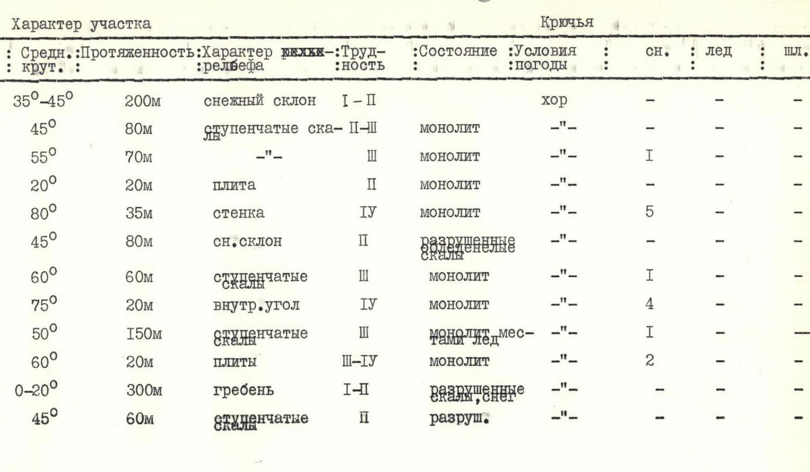
| Designation of the section | Average steepness | Length | Relief characteristics | Difficulty | Condition, conditions | rock | ice | bolt |
|---|---|---|---|---|---|---|---|---|
| ІЗУП-77 R0–R1 | 35°–45° | 200 m | snowy slope | 1–2 | good | – | – | |
| -" - R1–R2 | 45° | 80 m | stepped rocks | 2–3 | monolithic | – | – | |
| -" - R2–R3 | 55° | 70 m | -" - | 3 | monolithic | 1 | – | – |
| -" - R3–R4 | 20° | 20 m | slab | 2 | monolithic | – | – | |
| -" - R4–R5 | 80° | 35 m | wall | 4 | monolithic | 5 | – | – |
| -" - R5–R6 | 45° | 80 m | snowy slope | 2 | destroyed rocks | – | – | |
| -" - R6–R7 | 60° | 60 m | stepped rocks | 3 | monolithic | 1 | – | – |
| -" - R7–R8 | 75° | 20 m | internal corner | 4 | monolithic | 4 | – | – |
| -" - R8–R9 | 50° | 150 m | stepped rocks | 3 | monolithic, местами лёд | 1 | – | – |
| -" - R9–R10 | 60° | 20 m | slabs | 3–4 | monolithic | 2 | – | – |
| -" - R10–R11 | 0–20° | 300 m | ridge | 1–2 | destroyed rocks, snow | – | – | |
| -" - R11–R12 | 45° | 60 m | stepped rocks | 2 | destroyed | – | – |