Ascent Passport
- Climbing area — Central Caucasus, Adyr-Su gorge, Western spur from Mt. Stal, section 2.4.1 according to KMGV.
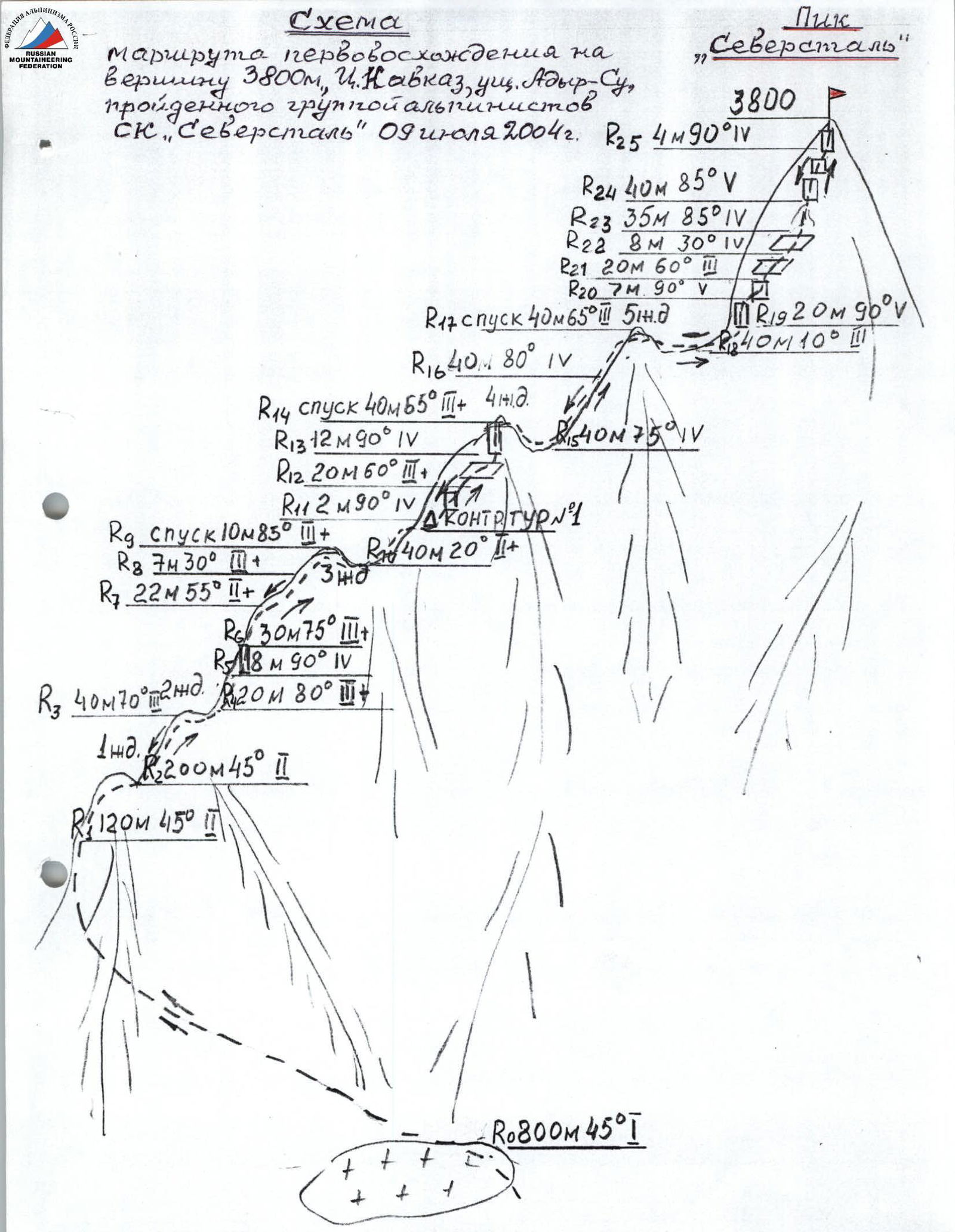
- Peak, route: Peak 3800 m (Peak "Severstal") via the Western ridge.
- Estimated category of difficulty: 3B, first ascent.
- Route character — rocky.
- Height difference: 800 m.
- including 393 m of actual wall section.
- total route length — 1685 m
- wall section length — 865 m
- including:
- 3rd category of difficulty — 177 m.
- 4th category of difficulty — 149 m
- 5th category of difficulty — 67 m.
- average steepness of wall section — 56.33°
- average steepness of the route — 44.23°
- Pitons driven in (numbers in the denominator are for ITO):
- rock pitons — 2, ice pitons — 0;
- chocks — 37, bolt pitons — 0
- Number of walking hours / days: 8 h 30 min.
- There was no overnight stay on the route.
- Leader: Pechenin Vasily Mikhailovich, Master of Sports of the USSR.
Participants:
- Mironov Alexander Alekseevich — 1st sports category
- Galeev Anton Khavisovich — 2nd sports category
- Veselov Vladimir Anatolyevich — 1st sports category
- Shumeyko Georgy Alexandrovich — 1st sports category
- Khudyakov Artem Ivanovich — 2nd sports category
- Terekhin Viktor Alexandrovich — 2nd sports category.
- Coach: Pechenin Vasily Mikhailovich, Master of Sports of the USSR, 1st category alpinism instructor, certificate No. 69.
- Departure for the route: July 9, 2004.
Reached the summit: July 9, 2004. Returned: July 9, 2004.
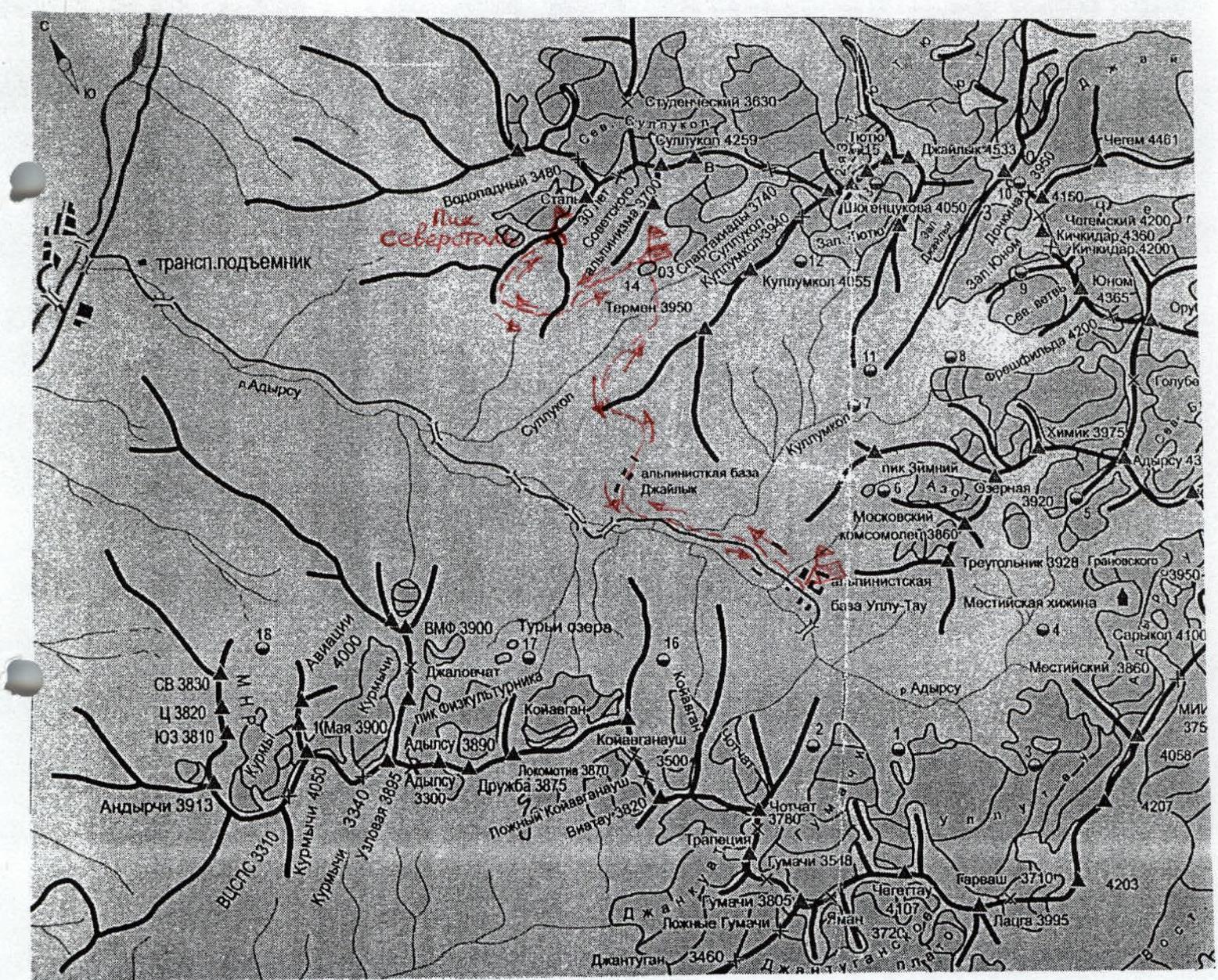
Route map of the first ascent to Peak 3800 m, Sullukol gorge, Central Caucasus on July 8–10, 2004
Start of the route. July 9, 2004 7:30
I. Brief geographical description of the ascent object
Peak 3800 m is located in the Adyr-Su gorge area of the Kabardino-Balkarian Republic (Central Caucasus) in the western spur from Mt. Stal.
The path to the peak from the "Ullu-Tau" alpine base camp (AUSB) goes along the road to the "Dzhailyk" AUSB. Beyond the main building — along a overgrown road and then — along an overgrown trail, exit the forest to the beginning of a steep grassy slope. Climb straight up this steep slope for 150–200 m along a beaten trail, and, turning left at the top, move to a more gentle part of the trail with small ascents and descents, traversing the slope, reach the Sullukol River. Ascend along the orographic left side of the Sullukol River to the moraine until you reach a lake, where there are overnight stays.
From "Ullu-Tau" AUSB to the overnight stays by the lake — 4–5 hours. From the overnight stay:
- cross the river,
- ascend to the moraine, turn left and reach the ridge to the right of the second from the bottom rocky outcrop. Then, traverse along the slope, reach the second ridge, from which descend down to a snowfield. From the overnight stays to the descent under the main ridge — the start of the route — 1.5 hours. Working time from the base camp in "Ullu-Tau" AUSB — 6.5 hours. The group completed the first ascent to Peak 3800 m from July 8 to 10, 2004. Weather conditions: light rain and low clouds in the second half of the day.
II. Reconnaissance results
The reconnaissance of the ascent route to Peak 3800 m was conducted on July 7 by the duo Pechenin V.M. – Mironov A.A., and then on July 8 by the entire group. Upon examining Peak 3800, a route was chosen for the ascent along the western ridge with five "gendarme" peaks and a 120-meter pre-summit rocky wall.
From Peak 3800 m, the following directions branch out:
- to the east — a sheer 100-meter wall and further a destroyed ridge with sharp "fins" towards Mt. Stal;
- to the southeast and southwest — rocky ridges.
From the south, a severely destroyed rocky wall leads to the peak, where rockfall is possible.
During the first ascent, the group planned to complete the entire route from the overnight stays by the lake in one daylight period. A descent from the peak along the ascent route was planned. The group assessed the route of the first ascent as category 3B. In terms of character and complexity, the ascent route to Peak 3800 m is comparable to the route to Peak Latsha along the Southern ridge, category 3B.
The photograph of Peak 3800 m was taken from the last counterfort before descending to the start of the ascent route. The group intended to dedicate their first ascent to the 50th anniversary of the Cherepovets Metallurgical Plant, JSC "Severstal", celebrated in 2005, and by right of the first ascenders, name Peak 3800 m as "Peak Severstal".
The group paid special attention to passing rockfall-prone sections of the route, for which they chose the ascent route along the western ridge.
Before proceeding with the first ascent, the group received consultations from:
- the head of educational and sports work at "Ullu-Tau" AUSB, Honored Master of Sports of the USSR Porokhnya Yu.I.
- head of rescue, Master of Sports of the USSR Zaitsev K.K.
III. Organizational and tactical plan of the first ascent
The first ascent to Peak 3800 m in the Sullukol gorge from "Ullu-Tau" AUSB was planned to be completed from 8:00 on July 8 to 17:00 on July 10, 2004, i.e., within three days. Based on the plan, a group of 7 people was provided with food for 3 days and necessary equipment. The weight of the backpack was 17.5 kg.
Group support.
a) Standard, additional, special equipment: 3 × 50 m climbing ropes; 7 × 4 m auxiliary ropes; 60 carabiners; 7 ice axes; 2 rappel slings; 2 rock hammers; 2 sling-extenders; 10 rock pitons; 7 pairs of rock climbing shoes; 20 chocks; 7 self-belay loops.
b) Camping equipment and clothing: 7 personal equipment items; 1 first-aid kit; 7 down sleeping bags; 2 tents; 7 down jackets; 7 rain ponchos; 7 protective helmets; 1 stove; 4 boxes of matches; 3 liters of gasoline; 2 candles; 2 pots.
c) Communication means: 1 "Lastochka" radio station; 2 sets of radio power supply; 2 flashlights.
The weight of the daily ration per participant was 800 g.
The group departed for the route according to plan on July 8 at 7:00 from "Ullu-Tau" AUSB, which allowed them to use the morning hours to reach the main trail, into the Sullukol gorge, transition to the overnight stays by the lake, and reconnaissance of the possible approach to the start of the route.
On July 9 at 6:00, the group departed from the bivouac and was at the start of the route in 1.5 hours. Within 2 hours, the group reached the western ridge. Starting from the 3rd "gendarme" and up to the summit, the group climbed in rock climbing shoes. Ropes proceeded in turns. On difficult sections of the route, the lead climber went without a backpack. On certain sections of difficult rock climbing, vertical fixed ropes were organized. Checkpoint #1 was established under the base of the upper part of the 4th "gendarme"; the main cairn was established at the summit. Arrival at the summit was at 16:00.
IV. Composition of the assault group
- Pechenin V.M. — Master of Sports of the USSR, leader of the first ascent.
- Mironov A.A. — 1st sports category, participant in the first ascent.
- Galeev A.Kh. — 2nd sports category, participant in the first ascent.
- Veselov V.A. — 1st sports category, participant in the first ascent.
- Shumeyko G.A. — 1st sports category, participant in the first ascent.
- Terekhin V.A. — 2nd sports category, participant in the first ascent.
- Khudyakov A.I. — 2nd sports category, participant in the first ascent.
No changes were made to the composition of the assault group. The entire group completed the first ascent in full.
V. Overall assessment of the actions of the assault group participants during the ascent
During the ascent, the rope teams proceeded in the following composition:
- Pechenin V.M. – Mironov A.A. – Shumeyko G.A.
- Galeev A.Kh. — Veselov V.A.
- Khudyakov A.I. – Terekhin V.A.
The load and duties within the team were distributed to ensure an even workload among participants: Khudyakov A.I. was responsible for operating the stove; Terekhin V.A. — for food preparation and ration management; Veselov V.A. — for radio communication; Mironov A.A. — for documenting the route description; Shumeyko G.A. — for gasoline management; Galeev A.Kh. — for photography.
On both ascent and descent, the rope teams proceeded in turns, worked on the route in coordination, very harmoniously, calmly, and confidently. There were no remarks regarding the participants' climbing techniques, belaying, or descent organization. All participants of the assault group demonstrated good mastery of mountaineering techniques and a will to win.
Leader and coach of the team, Master of Sports of the USSR, 1st category instructor Pechenin V.M.
Supplement to the table
During the passage of the route, one checkpoint was established under the base of the upper part of the 4th "gendarme". All rocky sections of the route were traversed using free climbing without the use of artificial aids or bolt pitons. The summit is a monolithic rock with a small inclined platform at the top.
The main cairn was built 4 meters below the summit platform, under a sheer rocky wall, where a commemorative plaque made of stainless steel is attached. Inside the cairn, a sealed tin can with a note from the first ascenders was placed, stating the following:
- The peak with a height of 3800 m is named Peak "Severstal".
- The name is given on the eve of the 50th anniversary of the Cherepovets Metallurgical Plant, JSC "Severstal".
On the commemorative plaque affixed at the summit, the following words are engraved:
- Peak "Severstal"
- On the eve of the 50th anniversary of the Cherepovets Metallurgical Plant, JSC "Severstal"
- July 2004
- 9.11.04
Pechenin V.M.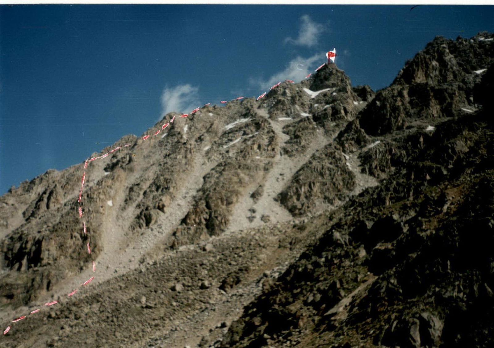
Peak "Severstal" from the ridge of the counterfort
Section R19–R25
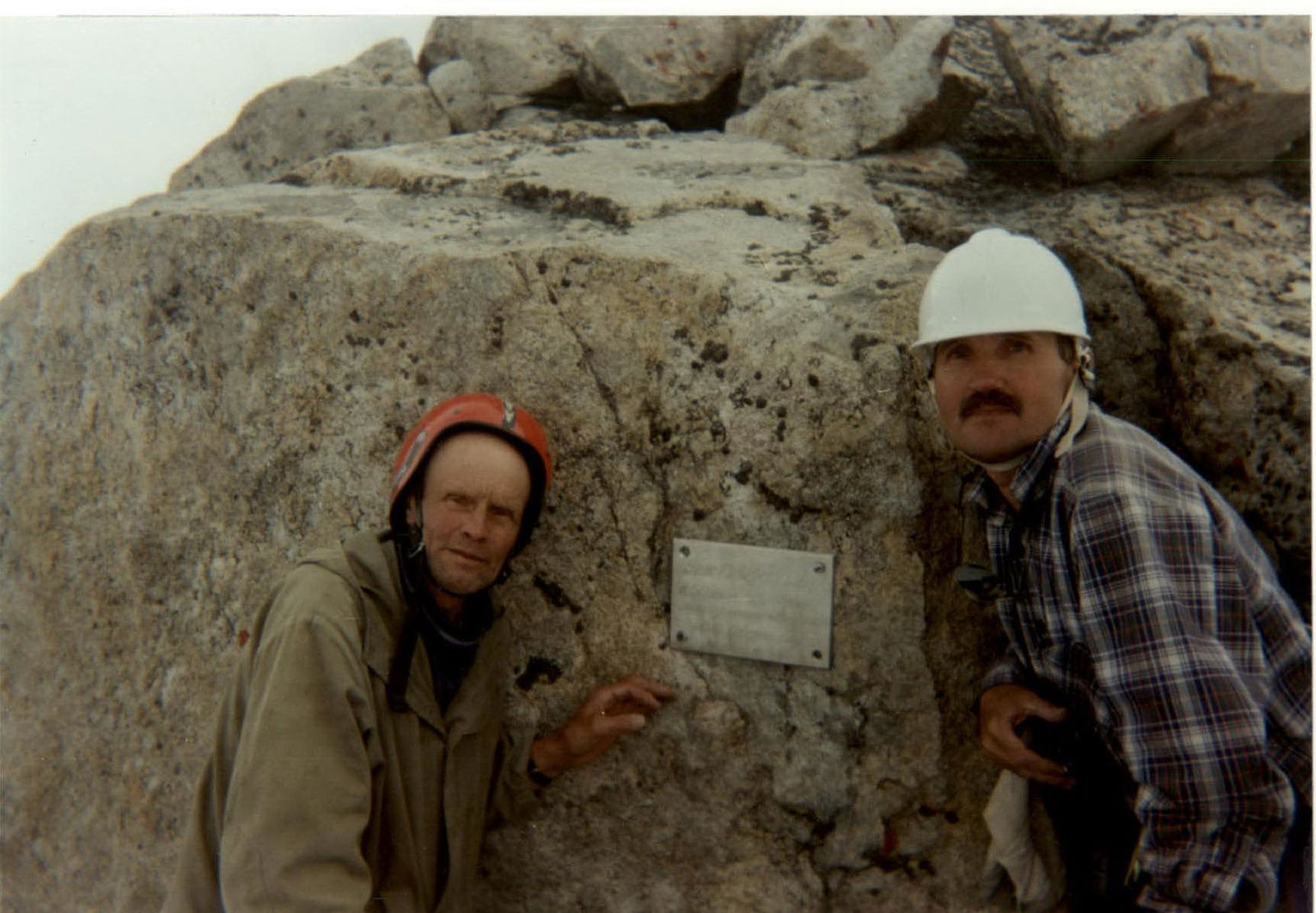
Commemorative plaque at the summit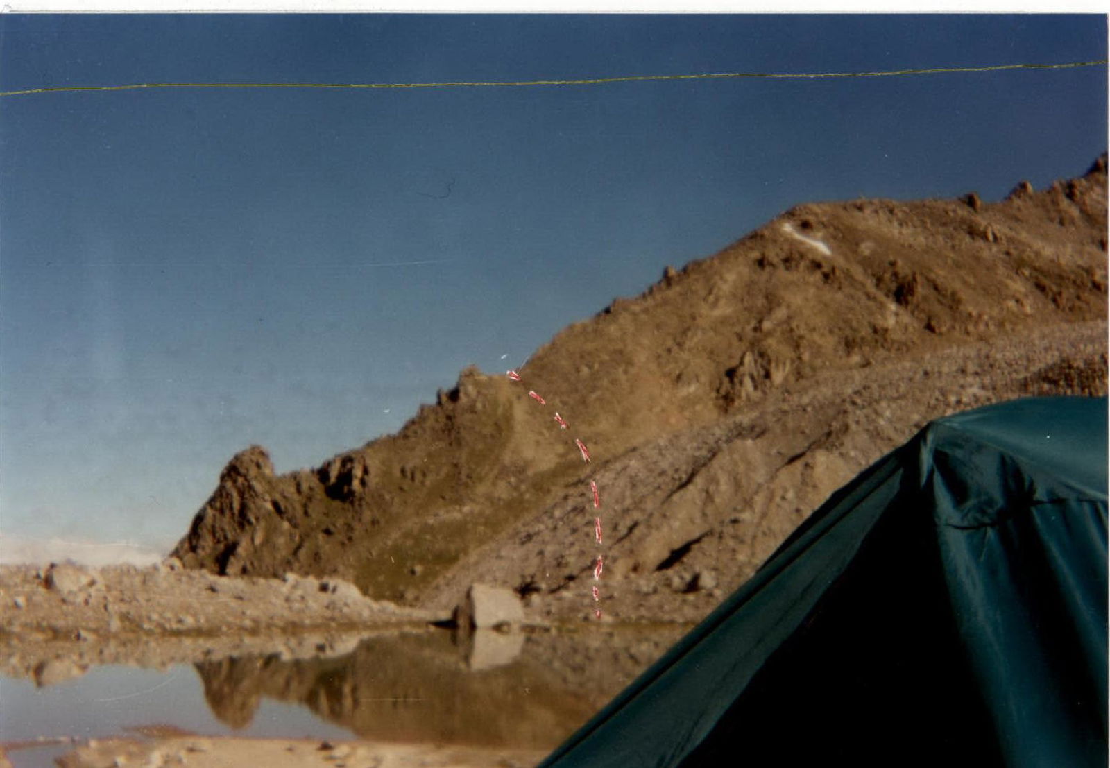
Start of the approach route from overnight stays by the lake