2.4.1748
I. DESCRIPTION OF THE TRAVERSE OF THE PEAKS PIK KILAR "FIZKULTURNIC STALIN" - KAYARTA-BASHI 3A cat. diff.
The first ascent of the route was made on May 14, 1961, by a group of climbers from Tyrnyauz, consisting of:
- Shamaev I.A. - leader
- Fatakhov Kh.A.
- Drobot S.Yu.
The group assessed the route to Pik Kilar from the North Karata-Mu glacier (via the "Shakhtyor" pass) as 1B cat. diff.
Route Description
Day 1 - approach. From Tyrnyauz, ascend the gorge to the fork of the Sakashil-Su and Kayarta-Su rivers; before descending to the suspension bridge over the Kayarta-Su, turn right-up along a well-developed pack trail - into the Kayarta-Su gorge. After 0.5 hours and 40 minutes of walking, the trail leads to a small clearing with tall grass and a large stone, and soon exits to meadows near the summer pastures. From the clearing, another 200-300 meters of trail goes through the forest, then exits to meadows, onto a small grassy ridge (with an irrigation ditch along it). Further along the trail, along a stream, through meadows, ascending low grassy hills, we approach the river. Passing small clearings with a stream, we ascend along the cliff above the riverbank and exit to the point where the gorge turns. The gorge turns almost 90° to the left (southeast). Before reaching the river bend, at the beginning of a steep, overgrown with rhododendrons cape on the opposite bank, cross the river where a convenient ascent to the cape is visible. Ascending to the cape, the trail goes along a wide terrace along the high, steep riverbank. Overcoming a small stony ridge, we descend to a large grassy area with a stream.
Ahead, a high ridge of the terminal moraine of the North Kayarta-Su glacier and the snowy ridge of the upper cirque with a small sharp triangle of Pik Kilar are visible. Another 4-5 hours of walking from Tyrnyauz. Another 0.5 hours of walking to the last grassy areas near the stream. Here, a bivouac is set up for exits to the glacier and to the "Gorniak" pass in the Sakashil gorge. Ascending to the edge of the terminal moraine opposite the western (right-hand) branch of the glacier, and passing by a small lake under the glacier tongue (leaving it to the right), we exit to the glacier. Along the glacier, we exit to the upper cirque, opposite the North wall of Pik Kilar. Turning left, we approach the foot of the ridge where it becomes more gentle, forming a small convexity, and along a snowy slope with a steepness of 25-30°, we ascend to the saddle of the "Shakhtyor" pass. Height - 3750 m.
The path to Pik Kilar initially goes along a gentle and even snowy ridge, then the ridge becomes steeper and narrower, with cornices hanging to the north (toward the Karatin cirque). Here, it is necessary to switch to the southern slope. Belay via ice axe. After traversing the slope for 3 ropes, we turn right and exit to the pre-summit ridge, and along it - first on snow, then on easy rocks - to the summit (1 rope). From the pass - 1-1.5 hours.
Descent from Pik Kilar - along the destroyed rocky ridge with small gendarmes, bypassing which does not present particular difficulties. Belay via pitons and rock outcrops. It is essential to organize the belay carefully when bypassing the gendarmes on the left (downhill), due to the steepness of the slope, which drops sheer into the Kestanty gorge. After the section with gendarmes (2 ropes), there is an easy rocky ridge, which then turns into a snowy one, with effective cornices. A small ascent, then descent to a small lake on a snowy-ice isthmus. Movement is simultaneous. From the isthmus, ascend along a gentle ice slope (2 ropes) to the ridge leading to the "Fizkulturnik" peak. Then, along a steep snowy slope, traversing it on the left, exit to the summit - a dome-shaped elevation on the ridge.
Its height is approximately 5 meters lower than Pik Kilar, i.e., it can be taken as 3900-3950 m. We found a note from "wild" Tyrnyauz climbers (Golovsky, Pimenov, et al.) from 1956.
Descending along the wide snowy ridge from the "Fizkulturnik" peak, we pass between two sharp gendarmes standing on the ridge like gates (we called them "Chegem gates"). After the "gates" - a large snowy area with a small lake (a suitable place for an overnight stay - there is water). From it begins the ascent of the North ridge of Kayarta-Bashi. The ridge is partly icy, partly covered with a layer of firn. Initially gentle, it then reaches a steepness of 50-60°. In the absence of crampons for all participants (there was only one pair), we had to cut steps. In the summer, the entire ridge will likely be icy, and to overcome it, crampons and ice axes will be required for all participants. The steep section of the ridge - 4 ropes, then a more gentle snowy ridge with cornices hanging to the west (toward Tyutyu-Su) follows. The path goes along the eastern slope (from the Chegem side) - 5-6 ropes. Belay via ice axe. Gradually, the ridge becomes more gentle, we exit to a snowy shelf and descend into a small snowy hollow between two ridges, and from it, along a snowy slope to the right, ascend to the summit - a small rock outcrop on the right (downhill) snowy ridge. From Pik Kilar to Kayarta-Bashi - 3 hours 30 minutes - 4 hours. In the cairn on the summit, we found a rusty tin can with rotten pulp instead of a note.
Descent from Kayarta-Bashi - along the Western ridge (it is possible to descend via the 1B cat. diff. route to the Shternberg pass, but the group chose the path along the Western ridge).
Initially, the path goes along a snowy ridge of medium steepness (3 ropes), then a steep ice slope begins, which the group bypassed along the rocks on the right (downhill), with a descent on a rope (one rope), then again exit to the ridge along the rocks (to the point reached on May 1st) and, along a gentle snowy slope, - descent to the Western Kayarta glacier.
Descent from the summit to the glacier - 2-2 hours 30 minutes.
The descent from the foot of the Western ridge of Kayarta-Bashi to the Tyutyu-Su gorge took 2 hours, i.e., the total time for the traverse (with descent to Tyutyu-Su) was 12-13 hours (and with a return to the bivouac in Kayarta-Su - would take 14-15 hours).
Along the Tyutyu-Su gorge, on a good trail, to Tyrnyauz - another 2 hours 30 minutes - 3 hours of walking.
The group assesses the route as 3A cat. diff.
Junior instructor (D. Kuzminsky)
 www.alpfederation.ru↗
2000
p. "Fizkulturnik" ~ 3950 m Chegem gates Kayarta-B. 4200 m ice slope Descent rope from p. Kilar Ledn. Zap. Kayarta invisible. participants of the Route (behind the ridge) place on the Western ridge, reached on May 1, 1961 glacier Orelyu In the Tyutyu-Su gorge, Shternberg pass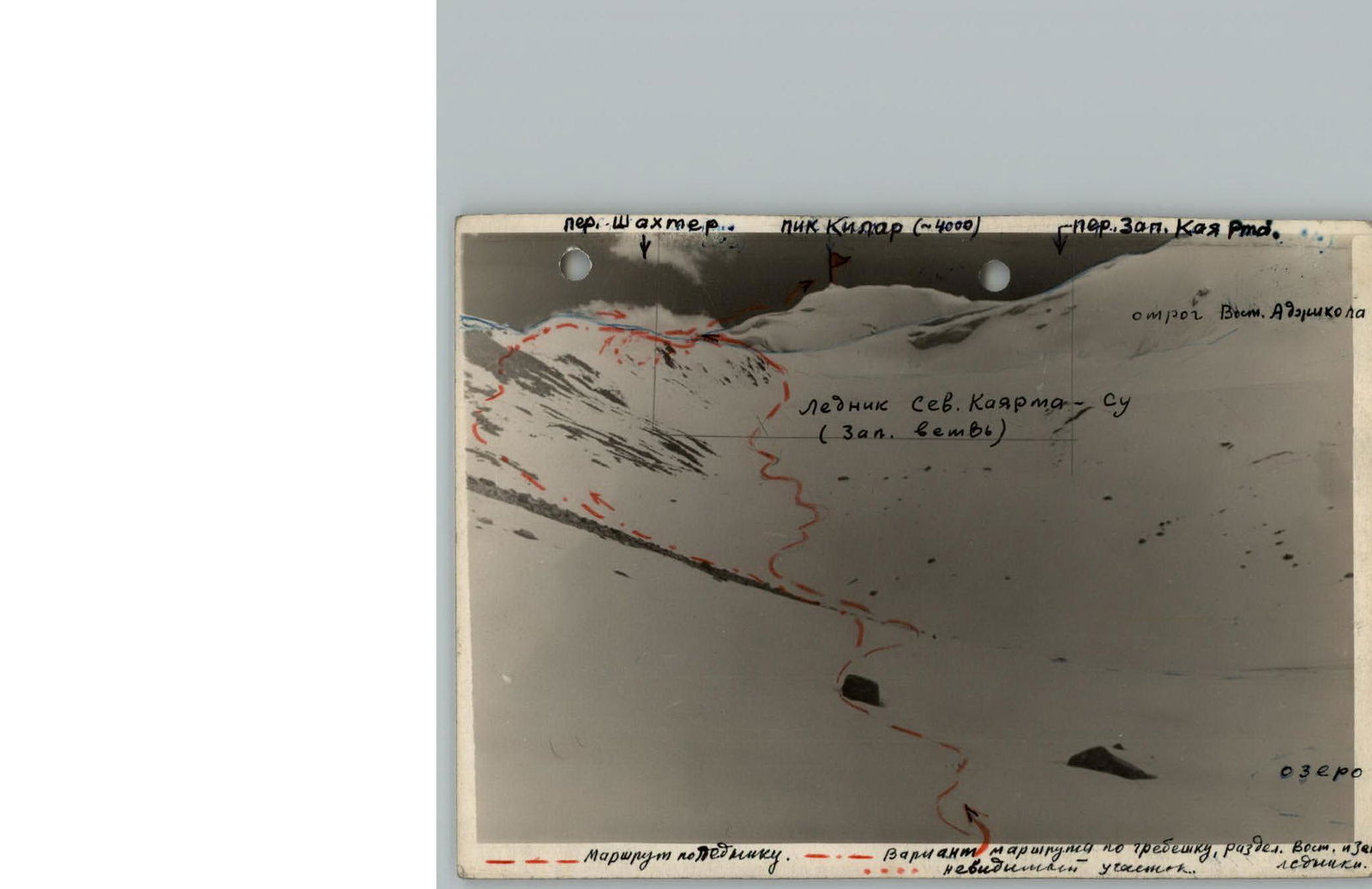 www.alpfederation.ru↗
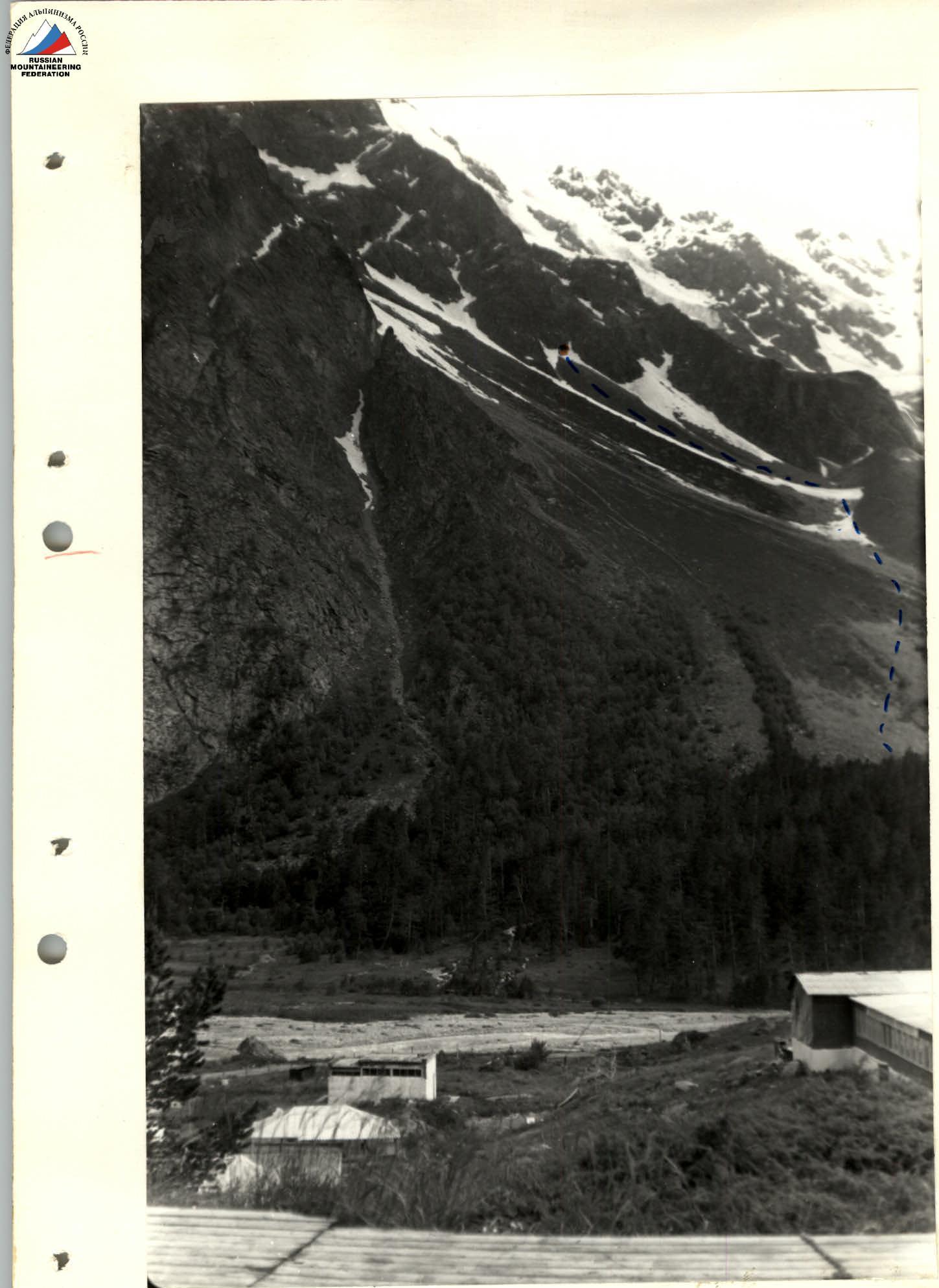
Photo #1. Path to the "Shakhtyor" pass and to Pik Kilar along the North Kayarta-Su glacier (western branch) photo by Kuzminsky Dv. July 1959
- www.alpfederation.ru↗
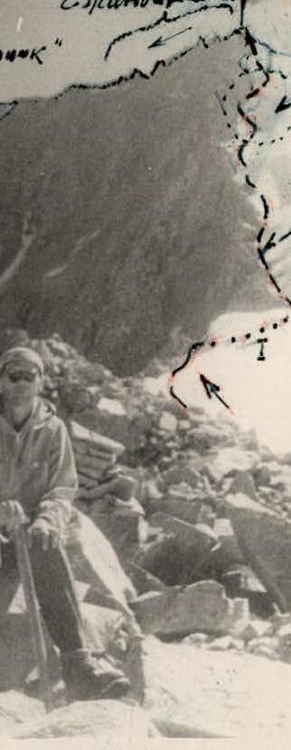
- Photo #2 on the "Shakhtyor" pass (3800) Path to the summit of Pik Kilar and the beginning of the descent to "Fizkulturnik" 7/8 1960 photo by E. Golovsky
- www.alpfederation.ru↗
- ridge with gendarmes icy firn slope Rocky shelf
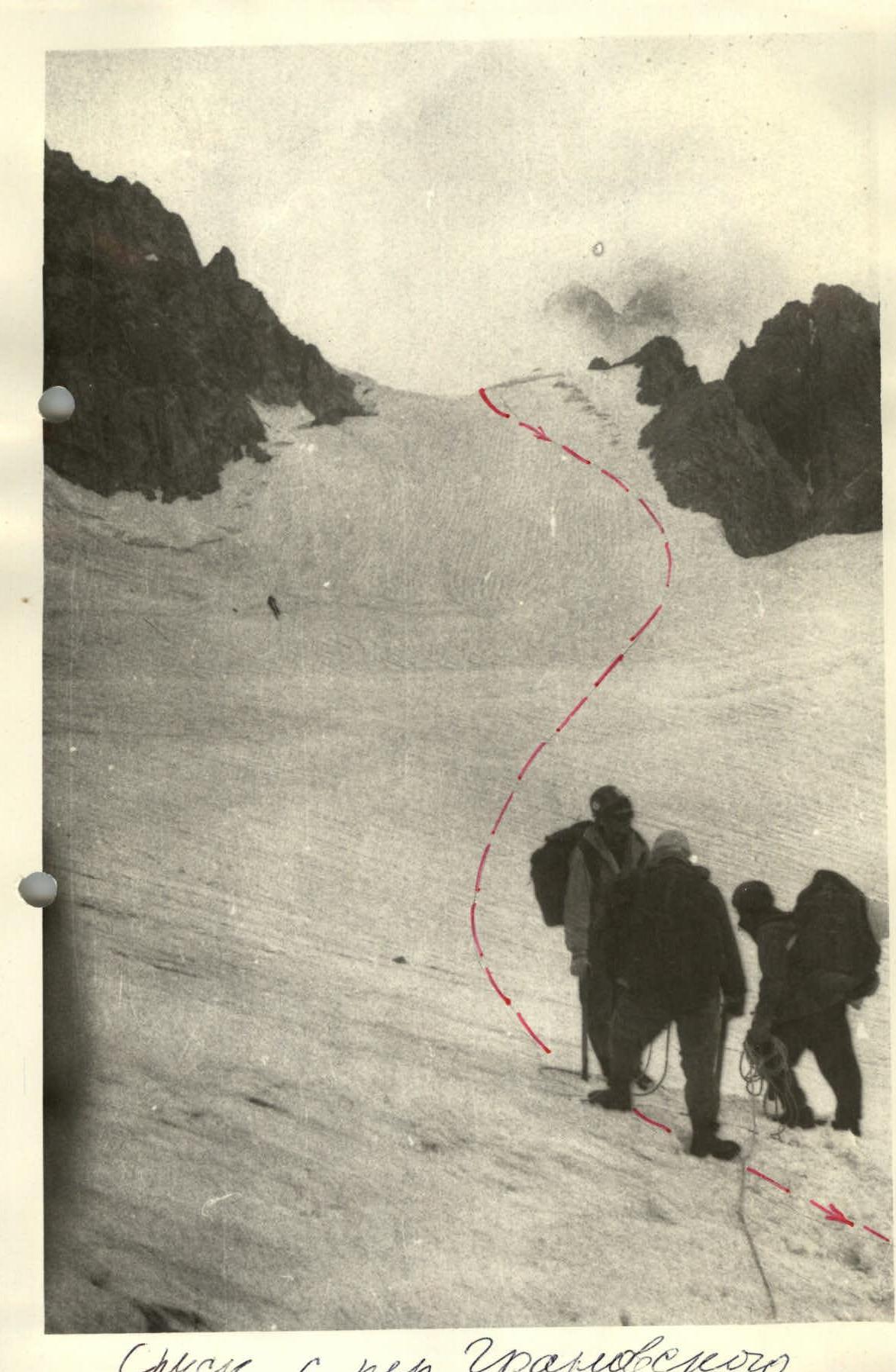
Photo #1 Kayarta-B. from the West (from the Adorikal-B. ridge) path of the traverse from the descent from p. Kilar to the descent along the Western ridge of Kayarta-B to the glacier under the Shternberg pass. ("Oreliu glacier") Photo by S. Drobot. May 1960 Descent from the Granovsky pass
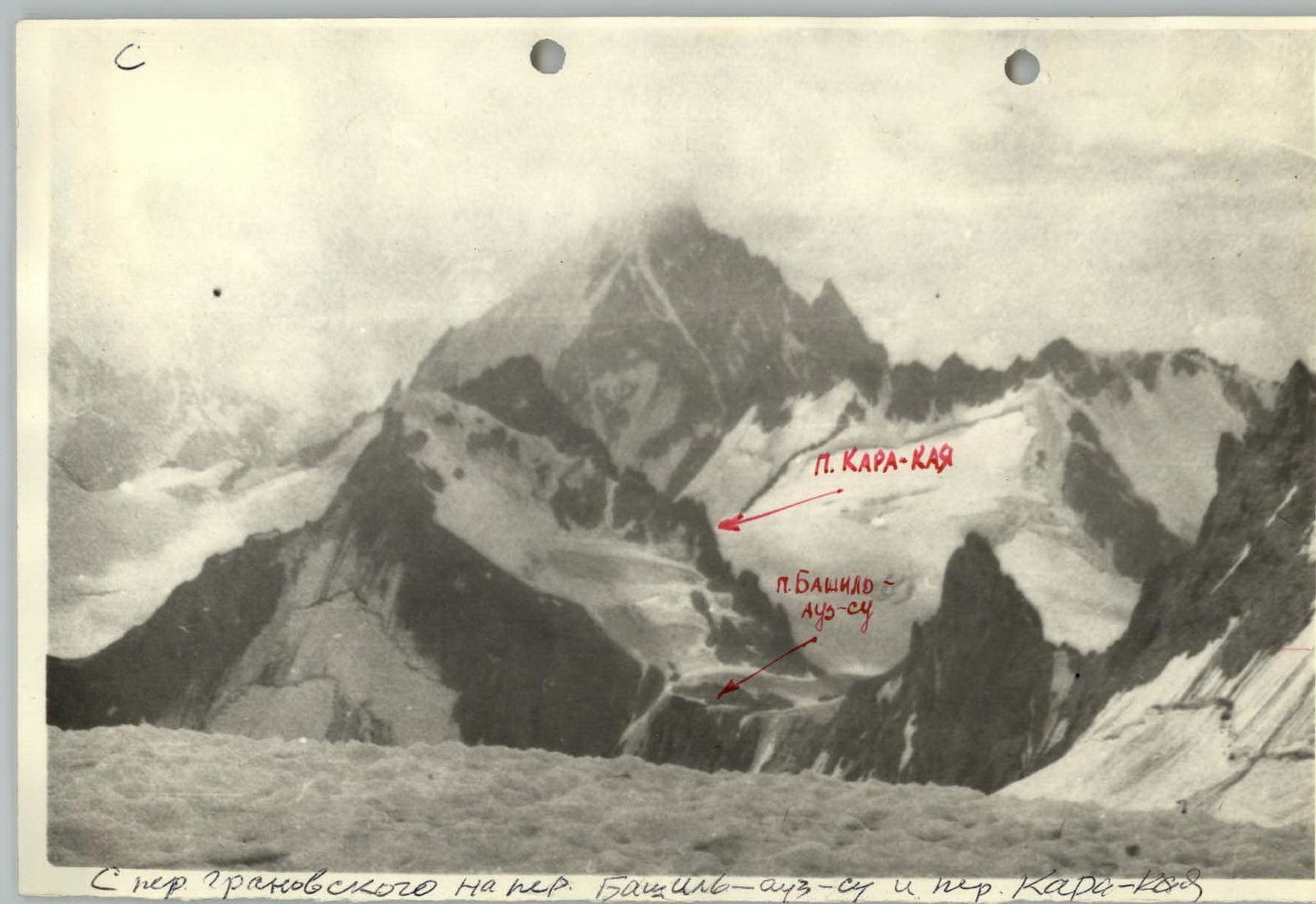 www.alpfederation.ru↗
 P. KARA-KAYA P. BASHIL-AUZ-SU Sper granovskogo on the Bashil-au2-su pass and the Kara-kal pass
 www.alpfederation.ru↗
Description of the approach to the route
From the AGLK "Dzhailyk", cross the bridge over the Adyr-Su river downstream. Behind the bridge, on the left, near the source, a trail begins, going through the forest up the slope in the direction of Lake Dzhalovchat. Ascending along the trail, cross to the left (green) moraine, leading to the north counterfort of the Eastern ridge in Koy-Avgan. Further ascent along the moraine. The north counterfort of the Eastern ridge is cut by a large couloir in its lower part. Along the green moraine, it is necessary to ascend until the upper part of the counterfort, cut by the couloir, begins to overhang on the left. Here, turn left and ascend up the slope to the rocks of the counterfort, leaving the couloir to the right. The beginning of the route is in the middle (between two rocky spurs) of the lower part of the bastion, which is crowned with a rocky tooth and connected by a narrow ridge to the main part of the counterfort.
Attention:
- The couloir to the right is prone to rockfall.
- At the beginning of summer, with a large accumulation of snow to the left of the counterfort along the slope, there is a risk of avalanches.
Approach to the route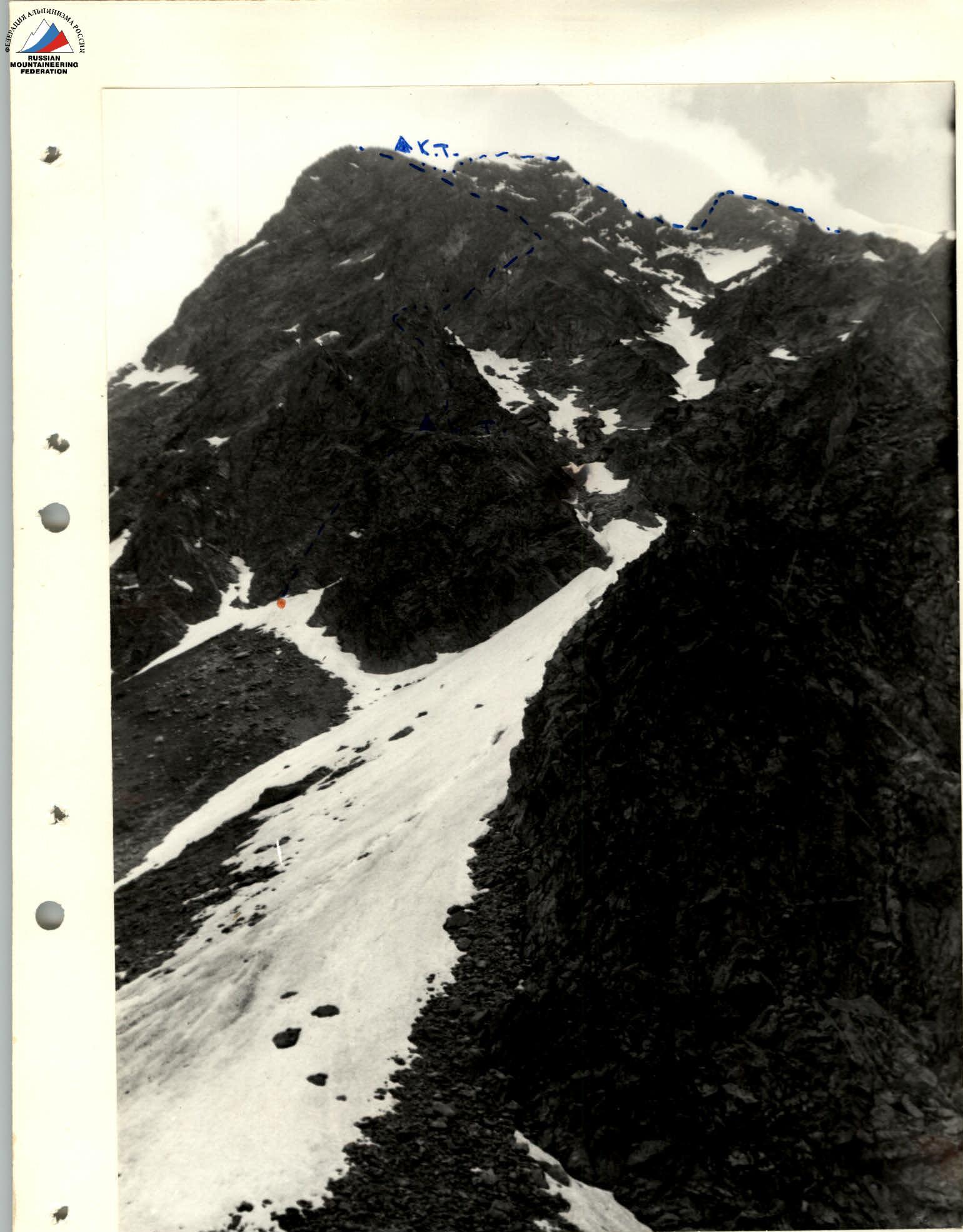
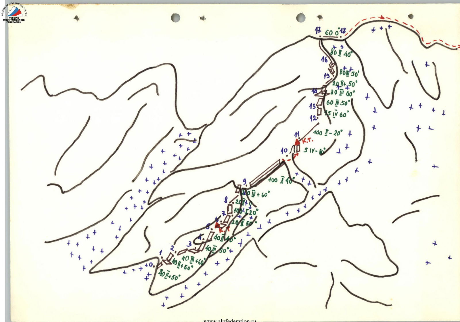
The beginning of the route. The route consists of two parts. First, movement occurs along the north counterfort with an exit to the Eastern ridge, where it connects with the route along the Eastern ridge 3A cat. diff. Further movement occurs along the route 3A cat. diff. to the summit. The diagram provides a description of the first part of the route along the north counterfort.
- R0-R1 - destroyed rocks.
- R1-R2 - traverse to the right 10 m along a talus shelf; to the left, the path seems simpler, but after 30 m, the rocks become although not very complex, but heavily worn, covered with moss and lichen; there are few cracks for organizing belay; therefore, it is recommended to go to the right.
- R2-R5 - destroyed rocks with small monolithic sections. Control cairn on a talus shelf.
- From the control cairn, movement along the shelf 40 m toward the couloir, and then turn left.
- R6-R9 - movement along the right part of the counterfort - destroyed rocks; at the end, a narrow shelf, from which ascent to the summit of the bastion (tooth) and descent 2 m to a saddle.
- R9-R10 - ascent to a small gendarme, which is bypassed on the right with an exit to the main ridge of the north counterfort. Here is the 2nd control cairn.
- R10-R11 - destroyed ridge.
- R11-R12 - steep ascent along the ridge.
- R12-R16 - movement along the ridge; try not to go to the right under the snow tongues, which may pose a danger (at the end of summer, there is an ice slope here).
- R17-R18 - the ridge becomes gentle and wide; at this point, the route connects with the route along the Eastern ridge 3A cat. diff.