СТЕНКА 5 ТОРКА 6 РЕЗОДУЮ КУ ТЯП 7 ТИНУТА 8 РЕЗОДОУ С КТОУ 9 ДЕРЕМУНКА 10 ОГ ПУНЬКА
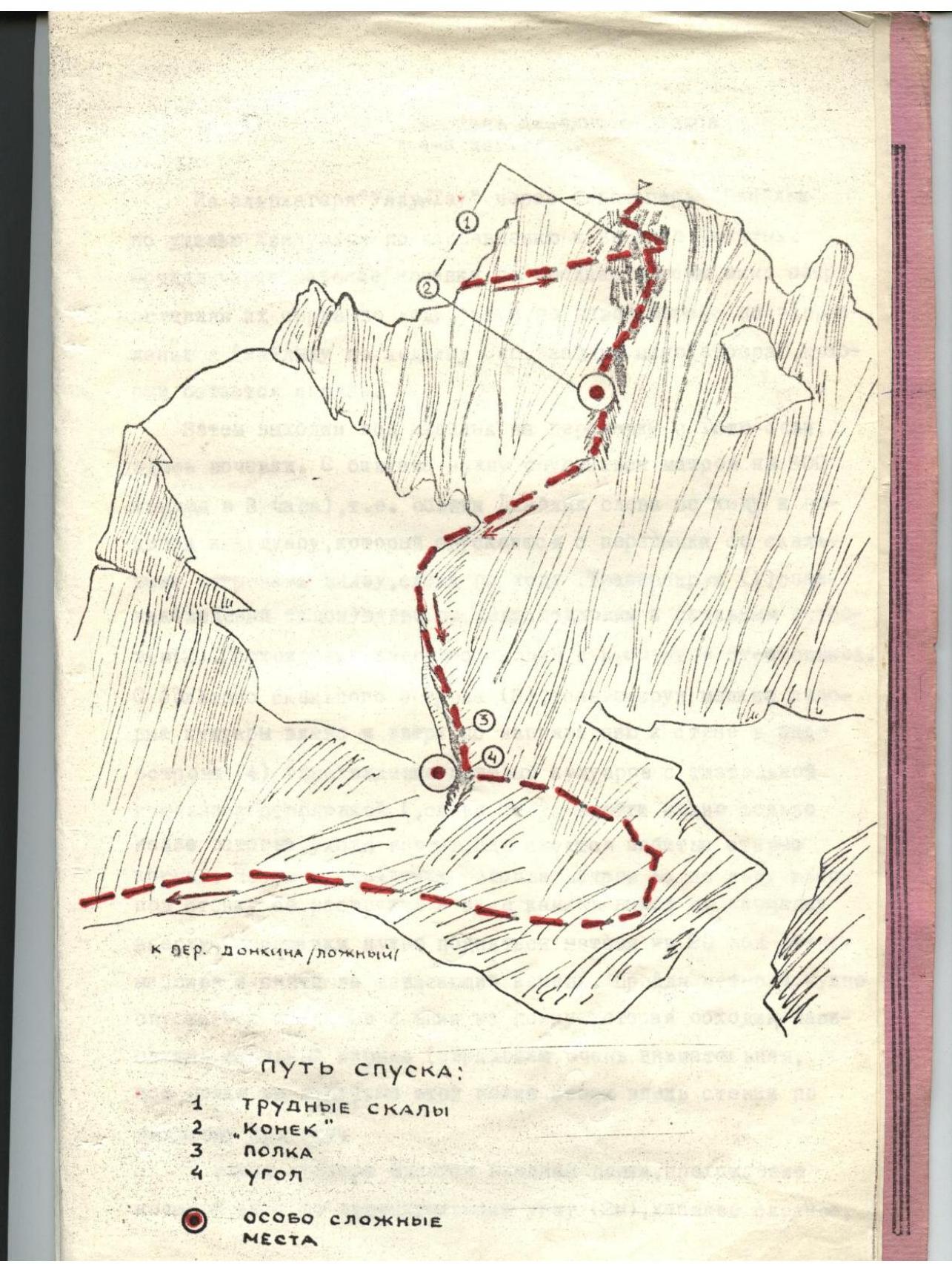
DESCENT ROUTE:
- DIFFICULT ROCK FORMATIONS
- "КОНЕК" (the "horse" or ridge)
- SHELF ("POLKA")
- SECTIONS (3) PARTICULARLY DIFFICULT SPOTS
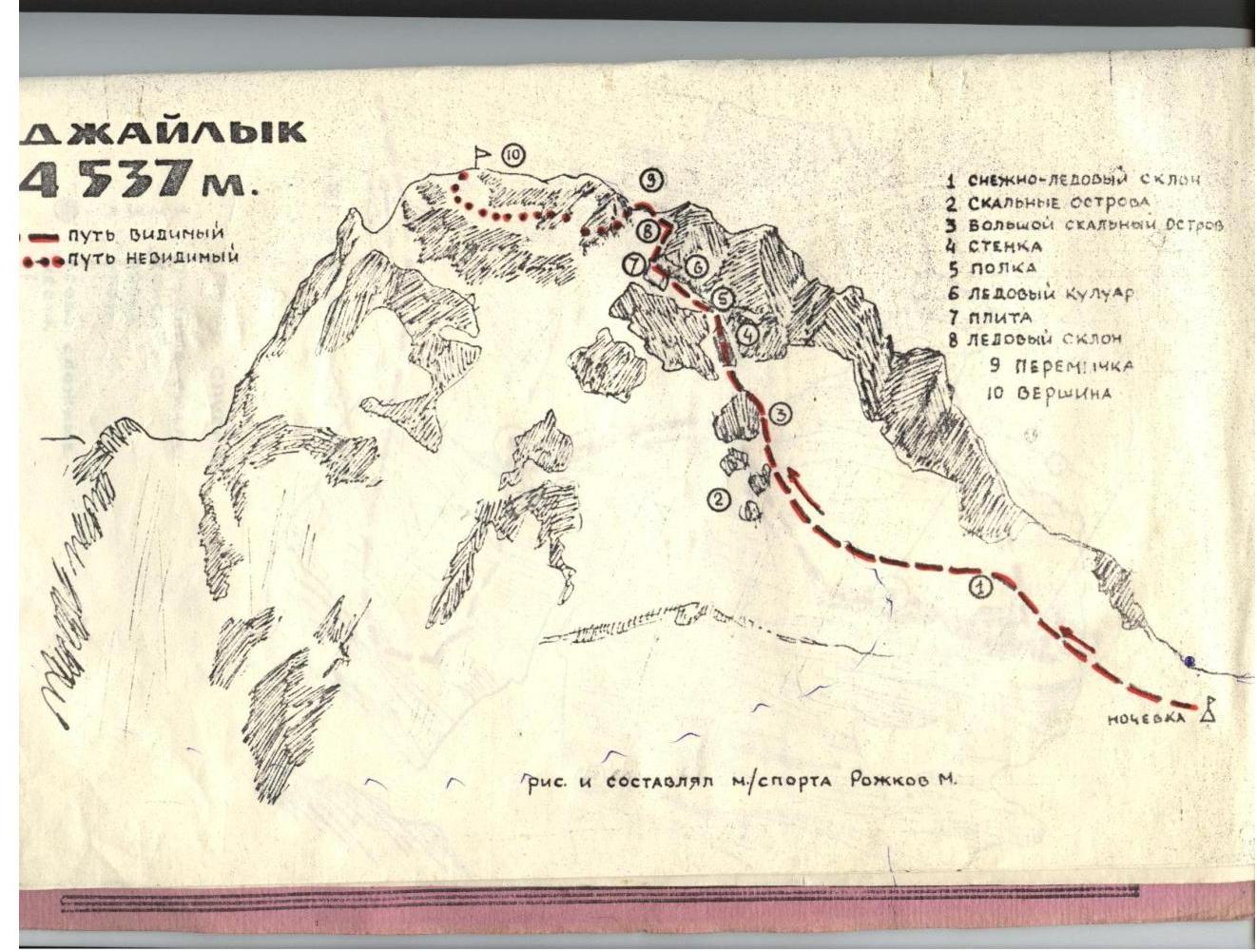
Ascent to Dzhadlyk Peak from the North, Category 4A difficulty
From the Ullu-Tau alp camp, through the Dzhaldyk alp camp, follow the Kollumkol gorge towards Dzhadlyk peak. After passing through the "paradise" campsites in the middle of the moraine, bypassing lakes on the right, then follow the left moraine towards Dzhadlyk via the Zapadny Dzhadlyk glacier, passing by the "fence" which remains on the right.
Then we reach the col between Dzhadlyk and Totyu-bashi, where we camp. From the bivouac, descend 300 meters (departure at 3:00 AM), i.e., bypass Dzhadlyk on the left and approach the couloir that descends from the col with rocky outcrops below, on the left.
Traversing:
- (1) a snowfield (ice slope) to the left, approaching the rocky outcrops (2).
Passing the ice slope with piton protection.
From the large rocky outcrop (3), traversing small ice couloirs to the left and upwards towards the wall in the form of an outcrop (4):
- passing ice couloirs with careful piton protection;
- to the left of the wall, it is only possible to pass through the outcrop by moving to the right, where old pitons are hammered in.
After passing the outcrop, ascend 15 meters up the ice towards the wall via a crack in the form of a chimney, exiting onto a ledge at the top.
From the ledge:
- ascend about 20 meters under the wall of the massif and climb onto an overhanging rock;
- after advancing 4 meters, descend 2 meters down to a shelf that bypasses the overhanging rock ledge (very careful protection, all shelves are in ice);
- follow this shelf upwards along the wall via an ice couloir.
At the end of the couloir, there is a smooth slab, the passage of which follows a negative angle (2 meters), with complex maneuvering; there are hammered-in pitons.
After passing the angle:
- there is a hammered-in piton,
- the movement towards it is very complex,
- requiring additional piton placement in the wall to the right.
Upwards from here, an ice slope of about 30 meters is visible, where a col can be seen.
Abseiling down this slope with piton protection, we reach the snowy col.
From the col, the summit is visible straight ahead, and a ridge is visible to the right. The exit onto the ridge follows the ice for about 30 meters, moving to the right along the ridge, leading to the "qvershle" ( summit ridge).
Along the shelf, bypassing the massif of the summit to the right, we ascend upwards, exiting under the summit and climbing in a spiral from bottom to top to the left. The traverse is about 7 rope lengths.
To the shoulder before the summit:
- Ascend upwards to the summit - about 30 meters.
Descent follows the Category 3B difficulty route.
Footnotes
-
1 ЧЕЛНО-РЕЗОДОУ С КТОУ 2 СРАЗОНЬЕ СЕТУРОГА 3 БОРНМОУ СРАЗОНЬЮ ОЕТЮГО 4 ↩