Passport
-
Climbing category — technical.
-
Climbing area — Central Caucasus, North-West spur from the Bodorku peak of the Main Caucasian Range.
-
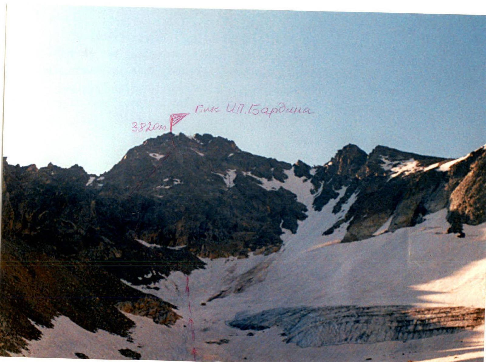
Peak, route: Peak 3820 m (Peak Acad. I.P. Bardin) via N-W wall.
-
Expected category: 4A–4B, first ascent.
-
Height difference: 1425 m
- including 445 m of actual wall section
- total route length — 1615 m
- wall section length — 511 m
- of which: 3 — 105 m
- 4 — 241 m
- 5 — 75 m
- average steepness of wall section — 61.12°
- average steepness of route — 50.79°
-
Number of pitons (figures in denominator are for ITO): rock pitons — 15, ice anchors — 38, bolt pitons.
-
Number of climbing hours/days — 7 h.
-
Overnight stops: none on the route.
-
Leader: Pechenin Vasily Mikhailovich, Master of Sports of the USSR
Participants:
- Efremov Yuri Spiridonovich, Candidate Master of Sports
- Mironov Alexander Alekseevich, 1st sports category
- Gareev Anton Khavisovich, 2nd sports category
- Veselov Vladimir Anatolyevich, 2nd sports category
- Shumeyko Georgy Alexandrovich, 2nd sports category
-
Coach: Pechenin V.M., Master of Sports of the USSR, 1st category instructor.
-
Departure to the route: July 21, 2002.
Summit: July 21, 2002. Return: July 21, 2002.
1. Brief geographical description of the climbing object
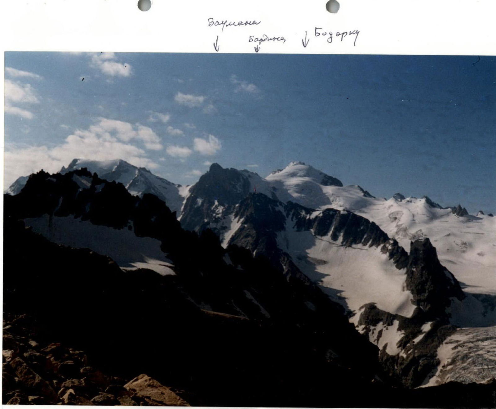
Peak 3820 m is located in the Bashil gorge of the Kabardino-Balkarian Republic (Central Caucasus) in the North-West spur of the Main Caucasian Range from Mt. Bodorku, beyond Mt. Bauman.
The path to the peak from the Ullu-Tau ASC goes along the trail on the left side of the Kullumkol gorge to the terminal moraine of the Yonom glacier. Then, on the trail, ascend to the "Lower Kichkidars bivouac" site — 3 h.
Approach via scree and moraine to the tongue of the Yonom glacier. Then, along the glacier or its left-bank moraine, ascend to the Middle Kichkidars bivouac — 1 h.
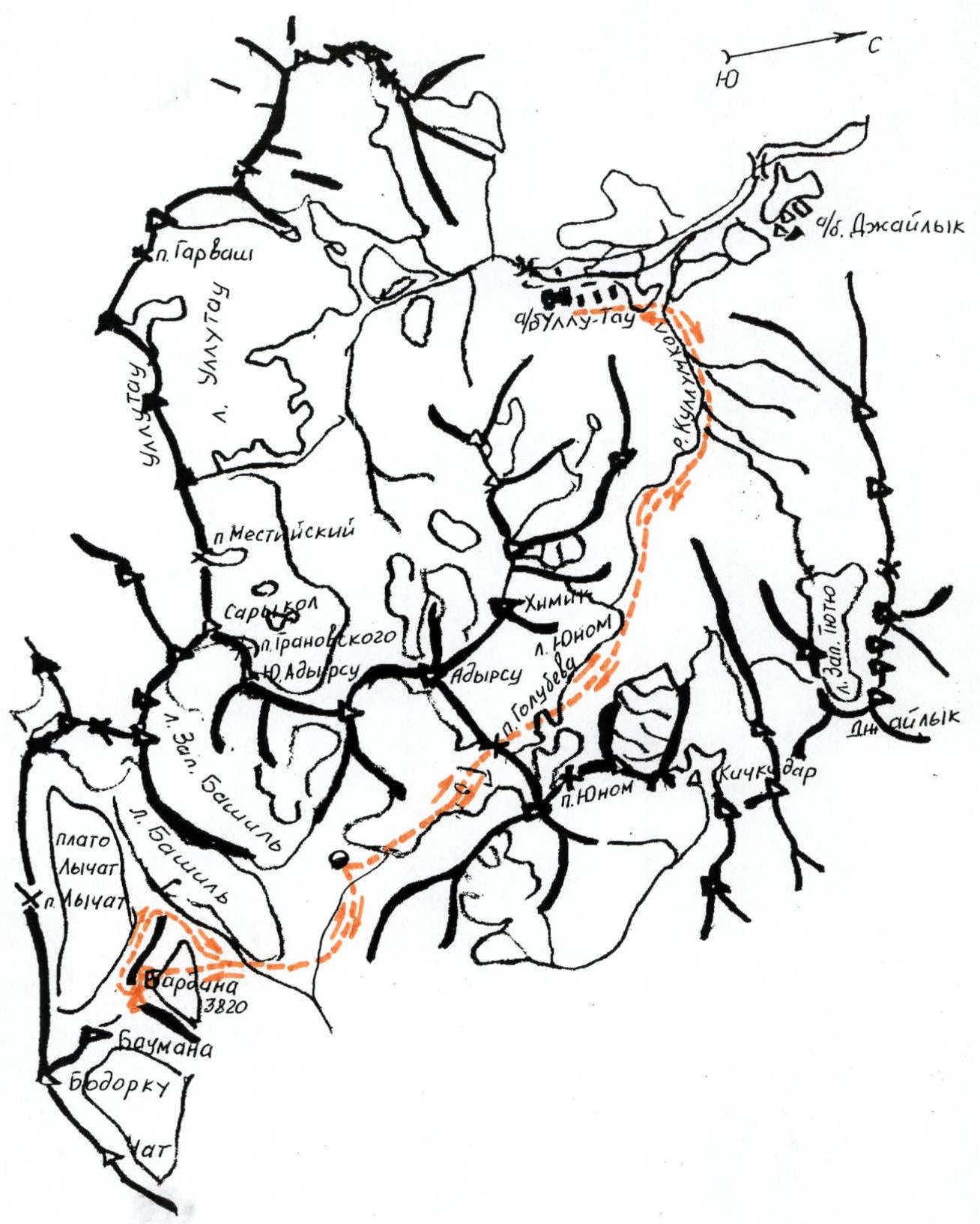
Route map of the first ascent to Peak 3820, Central Caucasus, July 19–22, 2002.
From the "Middle Kichkidars bivouac":
- descend right to the Yonom glacier;
- along its left side, approach the col of the Golubeva pass;
- cross the bergschrund;
- ascend the ice-snow slope to the central col of the Golubeva pass (move in rope teams; beware of cornices!) — 2 h.
From the pass:
- descend to the Severny Bashil glacier;
- along its left part, bypassing the icefall, descend to the terminal moraine of the Severny Bashil glacier;
- from there, along the left side of the river-waterfall, descend via the eroded steep moraine to the Bashil glacier under the start of the route — 3 h.
Working time from the Ullu-Tau base camp — 9 h.
The group made the first ascent to Peak 3820 m from July 19 to July 22, 2002.
Weather conditions: clear, weak wind, warm.
2. Reconnaissance results
The reconnaissance of the ascent route to Peak 3820 m was conducted by the entire team both from the Golubeva pass on July 19 and on July 20 — from the bivouac on the terminal moraine of the Severny Bashil glacier by two groups of 3 people:
- Pechenin V.M. — Mironov A.A. — Shumeyko G.A.
- Efremov Yu.S. — Galeev A.Kh. — Veselov V.A.
When viewing Peak 3820 m, it was noted that:
- 2/3 of the route passes through snow-ice slopes;
- 1/3 — through the summit part, passing through the rock wall.
Access to the rock wall is possible via snow-ice slopes with an exit to a snow-ice cirque with an exposed part of the ice wall.
To the right of Peak 3820 m, a destroyed rock ridge approaches, starting from the Bashil glacier with a steep 200-meter rock wall.
To the North-West, a highly destroyed rock ridge approaches the peak from the left. To the east of the summit, a rock ridge extends to the peaks "Peak Bauman" and "Peak Bodorku". During the first ascent, the group planned to complete the entire route from the bivouac on the terminal moraine of the Severny Bashil glacier in one daylight period. Two descent options were planned:
- descent along the southern ridge to the snow-ice couloir and down it to the snow-ice cirque and then along the ascent path.
- the second option — descent along the ridge, then descend left along the Lychat glacier plateau and down it to the Bashil glacier to the start of the route.
The group preliminarily assessed the first ascent route as 4A–4B category. A photograph of the peak was taken from the Golubeva pass bivouac. The group intended to dedicate their first ascent to the 50th anniversary of JSC "Severstal" and the 120th anniversary of its founder, academician-metallurgist I.P. Bardin, to be celebrated in 2003, and to name Peak 3820 m "Peak Academician I.P. Bardin". Special attention was to be paid to passing stone-hazardous and avalanche-prone sections of the route, for which the group avoided couloirs during ascent and descent.
Before the first ascent, the group received consultations from:
- the head of educational and sports work at Ullu-Tau ASC;
- Honored Master of Sports of the USSR, Porokhnya Yu.I.;
- head of rescue, Master of Sports of the USSR, Zaitsev K.K.
3. Organizational and tactical plan for the first ascent
The first ascent to Peak 3820 m in the Bashil gorge from Ullu-Tau ASC was planned from July 19 to July 22, 2002, i.e., in 4 days.
Based on the plan, a group of 6 people was provided with food for 3.4 days and necessary equipment. The backpack weight was 18 kg.
Group provision
a) standard, additional, special equipment:
- main rope — 3×40 m
- auxiliary rope — 6×4 m
- carabiners — 34 pcs.
- ice axes — 3 pcs.
- ice hammers ("shakal") — 3 pcs.
- rock pitons — 14 pcs.
- ice screws (ice pitons) — 10 pcs.
- crampons — 6 pairs
- rappel rings — 4 pcs.
- chocks — 22 pcs.
- extension slings — 4 pcs.
- self-belay slings — 6 pcs.
- rock shoes, galoshes — 6 pairs
b) bivouac equipment, clothing:
- personal equipment — 6 units
- first-aid kit — 1 pack
- down sleeping bags — 6 pcs.
- tents — 2 pcs.
- down jackets — 6 pcs.
- rain ponchos — 6 pcs.
- helmets — 6 pcs.
- stove — 1 pc.
- matches — 2 packs
- fuel (in liters) — 3 l
- candles — 1 pc.
- pots — 2 pcs.
c) signaling means:
- radio station (type) — "Lastochka" — 1 pc.
- radio station power supply (kit) — 2 kits
- flashlights — 2 pcs.
The weight of the daily food ration per participant was 800 g. The group departed on the route according to plan on July 19 at 6:00 from Ullu-Tau ASC, which allowed crossing the river via a bridge above the former alplager "Dzhailyk" and utilizing the morning hours to approach the Middle Kichkidars bivouac, and then reach the Golubeva pass.
On July 20, the entire day was spent descending to the terminal moraine of the Severny Bashil glacier, organizing a base camp, and scouting the possible ascent route and approach to the start of the route.
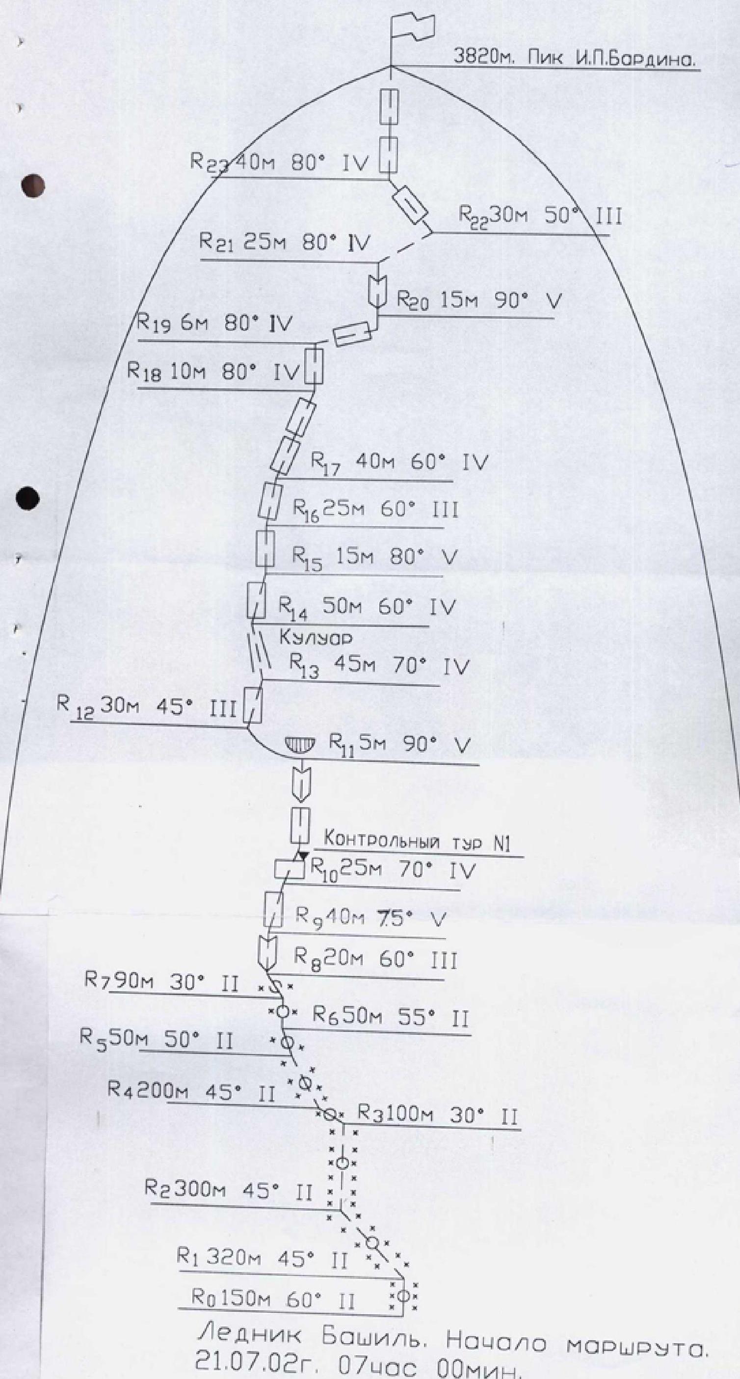
On July 21 at 5:50, the group departed from the bivouac and was at the start of the route within an hour. The snow-ice slope from the Bashil glacier to the foot of the rock wall was traversed in crampons, and on the rocks — in rock shoes and galoshes. Teams moved in front alternately. On difficult sections of the route, the first climber went without a backpack. On certain difficult rock sections, vertical rope systems were organized. Control cairn No. 1 was set up at the end of section R9, and a cairn was also established on the summit.
4. Composition of the assault team
- Pechenin V.M. — Master of Sports of the USSR, leader of the first ascent
- Efremov Yu.S. — Candidate Master of Sports, participant of the first ascent
- Mironov A.A. — 1st sports category, participant of the first ascent
- Galeev A.Kh. — 2nd sports category, participant of the first ascent
- Veselov V.A. — 2nd sports category, participant of the first ascent
- Shumeyko G.A. — 2nd sports category, participant of the first ascent
No changes were made to the composition of the assault team. The entire group completed the first ascent in full.
5. Overall assessment of the actions of the assault team participants during the ascent
During the ascent, teams moved in the following composition: Galeev A.Kh. — Efremov Yu.S., Veselov V.A. — Mironov A.A., Shumeyko G.A. — Pechenin V.M.
The load and duties within the team were distributed to ensure an even workload for the participants:
- Efremov Yu.S. was responsible for the stove, meal preparation, and photography;
- Veselov V.A. — for product consumption;
- Mironov A.A. — for documenting the route description;
- Galeev A.Kh. — for the radio station;
- Shumeyko G.A. — for fuel consumption.
On the ascent and descent, teams moved in front alternately, working on the route in coordination, very harmoniously, calmly, and confidently. There were no remarks regarding technique, belaying, or descent organization. All participants of the assault team demonstrated good mastery of mountaineering techniques and will to victory.
The leader and coach of the team, Master of Sports of the USSR, 1st category instructor — Pechenin V.M.
6. Supplement to the table
During the passage of the route, one control cairn was established at the end of section R9. All rock sections of the route were traversed using free climbing without artificial aids or bolt pitons.
The summit represents a rock ridge with three elevations. The main cairn is built on the rocks of the third elevation towards the Bashil gorge. A sealed capsule is placed inside the cairn, containing a note from the first ascenders, stating that:
- the peak with a height of 3820 m is named Peak Academician-Metallurgist I.P. Bardin;
- the name is given on the eve of his 120th anniversary;
- the name is also dedicated to the 50th anniversary of JSC "Severstal";
- I.P. Bardin is the founder of JSC "Severstal".
Near the main cairn on the summit, a commemorative plaque made of stainless steel is attached, engraved with the words: "Peak I.P. Bardin — Academician-Metallurgist — Founder of the Cherepovets Metallurgical Plant — to mark the 50th anniversary of JSC 'Severstal'".
October 10, 2002
Table of main route characteristics
| Date | Route section | Average length of iv | Average steepness of section, ° | Section characteristic (by relief character) | Section characteristic (by technical difficulty) | Section characteristic (by method of passage and belaying) | Time, h (bivouac stops) | Time, h (exit) | Time, h (climbing hours) | Number of rock pitons driven |
|---|---|---|---|---|---|---|---|---|---|---|
| 1 | 2 | 3 | 4 | 5 | 6 | 7 | 8 | 9 | 10 | 11 |
| 19.07.2002 | Ullu-Tau ASC – Golubeva pass | 14:00 | 6:00 | 8:00 | - | |||||
| 20.07.2002 | Golubeva pass – terminal moraine of Severny Bashil glacier | 8:45 | 6:45 | 2:00 | ||||||
| Reconnaissance of ascent path | 18:00 | 12:00 | 6:00 | |||||||
| 21.07.2002 | Ascent to Peak 3820 m (Bardin Peak) | 20:00 | 5:50 | 14:10 | ||||||
| R0 | 150 | 60 | snow-ice slope | 2 | In rope teams, belay via ice axe | |||||
| R1 | 320 | 45 | snow-ice slope | 2 | In rope teams, belay via ice axe | |||||
| R2 | 300 | 45 | snow-ice slope | 2 | In rope teams, belay via ice axe | |||||
| R3 | 100 | 30 | rock ridge | 2 | In rope teams, simultaneously | |||||
| R4 | 200 | 45 | snow-ice slope | 2 | In rope teams, belay via ice axe | |||||
| R5 | 50 | 50 | snow-ice slope | 2 | In rope teams, belay via ice axe | |||||
| R6 | 50 | 55 | snow-ice slope | 2 | In rope teams, belay via ice axe | |||||
| R7 | 90 | 30 | large and medium scree | 2 | In rope teams, simultaneously | |||||
| R8 | 20 | 60 | internal corner | 3 | Free climbing, belay via rock pitons | 3 rock pitons | ||||
| R9 | 40 | 75 | wall | 5 | Free climbing, belay via rock pitons, chocks | 3 rock pitons, 5 chocks | ||||
| R10 | 25 | 70 | difficult rocks with internal corner | 4 | Free climbing | 3 rock pitons | ||||
| R11 | 5 | 90 | wall | 5 | Free climbing | 1 rock piton, 2 chocks | ||||
| R12 | 30 | 45 | rocks | 3 | Free climbing | 2 chocks | ||||
| R13 | 45 | 70 | couloir | 4 | Free climbing | 5 chocks | ||||
| R14 | 50 | 60 | rocks | 4 | Free climbing | 1 rock piton, 4 chocks | ||||
| R15 | 15 | 80 | wall | 5 | Free climbing | 1 rock piton, 2 chocks | ||||
| R16 | 25 | 60 | rocks of medium difficulty | 3 | Free climbing | 3 chocks | ||||
| R17 | 40 | 60 | difficult rocks | 4 | Free climbing | 5 chocks | ||||
| R18 | 10 | 80 | wall | 4 | Free climbing | 3 chocks | ||||
| R19 | 6 | 80 | ledge | 4 | Free climbing | 1 piton | ||||
| R20 | 15 | 90 | internal corner | 5 | Free climbing | 1 rock piton, 3 chocks | ||||
| R21 | 25 | 80 | rock ridge | 4 | Free climbing, alternate belay | |||||
| R22 | 30 | 50 | rock ridge | 3 | Free climbing, alternate belay | |||||
| R23 | 40 | 80 | steep rocks | 4 | Free climbing, belay via ledges, chocks | 1 rock piton, 4 chocks | ||||
| Total: | 15 rock pitons, 38 chocks |
Route map of the first ascent to Peak 3820 m, Central Caucasus, July 19–22, 2002, traversed by a group of climbers from the SK "Severstal" alpine club.
Peak I.P. Bardin. View from Golubeva pass.
Commemorative plaque on the summit of Peak I.P. Bardin.

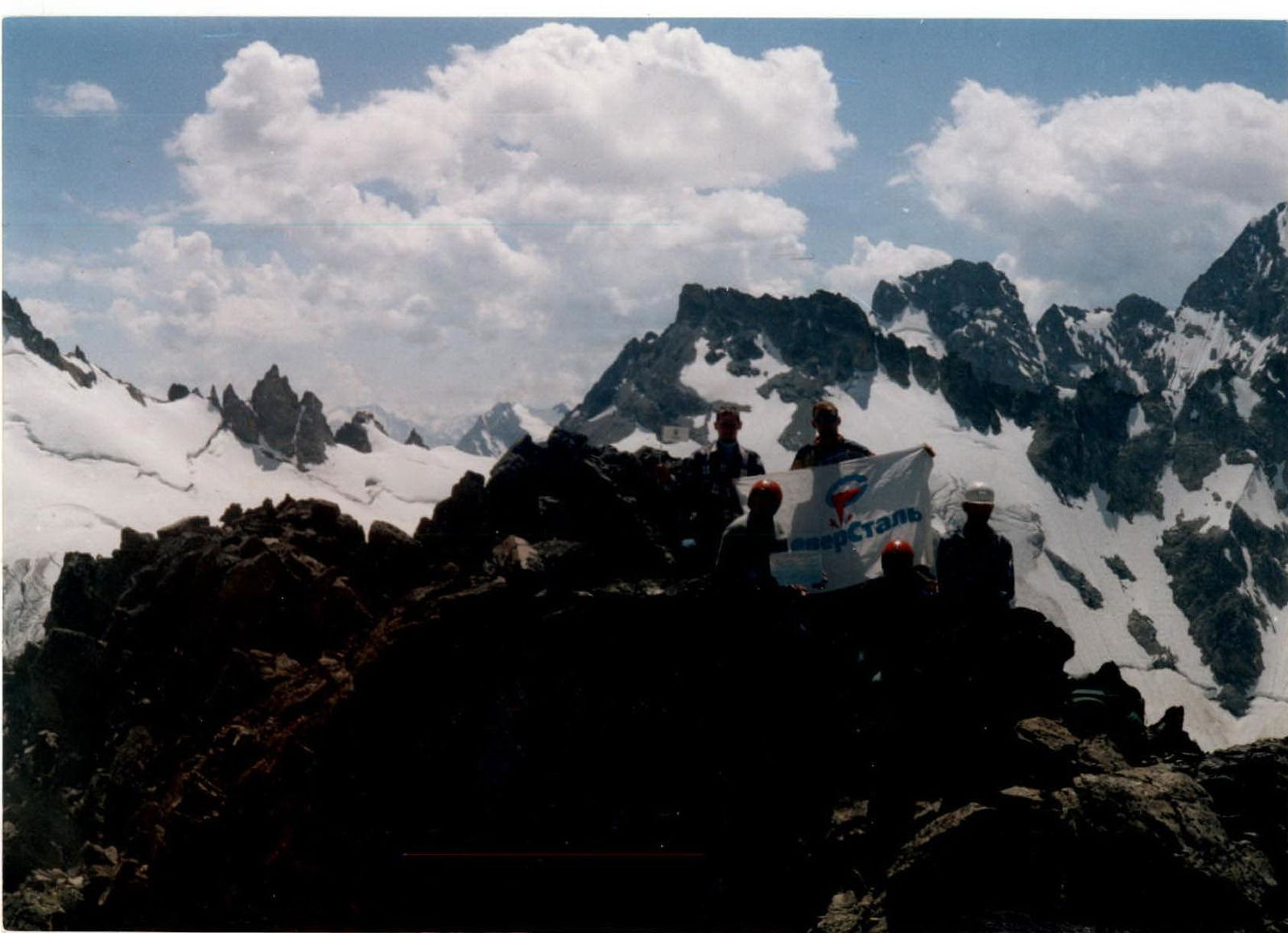
On the summit of Peak I.P. Bardin.