Ascent Passport
- Ascent class — technically challenging.
- Ascent area according to KTMGV — Caucasus. From Chiperazau Pass to Kitlod Pass.
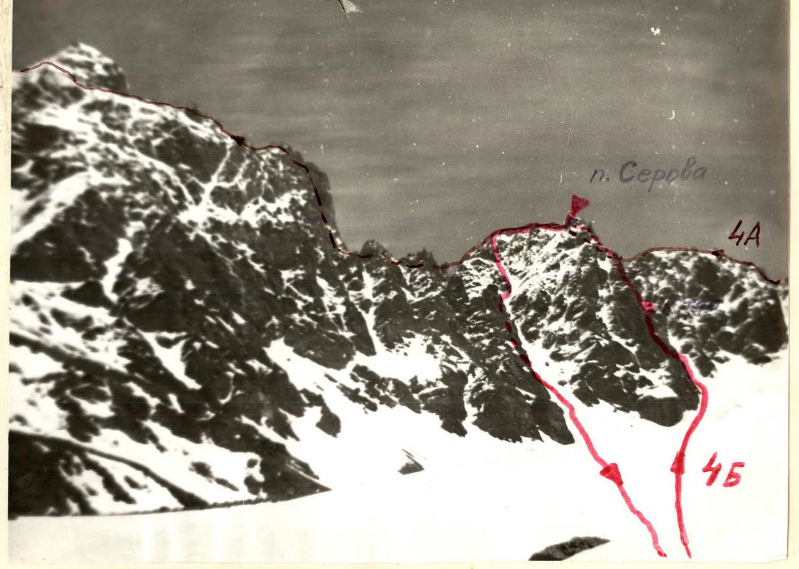
- Peak, its height, and ascent route — Serov Peak 4080 m, Southeast wall.
- Proposed difficulty category — 4B.
- Route characteristics:
- Elevation difference 500 m
- Average steepness 45–50°
- Section length:
- II — 230 m;
- III — 320 m;
- IV — 181 m;
- V — 11 m;
- VI — 4 m;
- Pitons hammered:
- For belaying:
- rock: 25
- ice: 0
- bolted: 0
- For creating artificial holds:
- 5
- 0
- 0
- For belaying:
- Number of climbing hours — 14 hours.
- Number of nights and their characteristics — none.
- Surname, name, patronymic of the leader and participants, their sports qualification:
- Radchenko Viktor Ivanovich — Candidate for Master of Sports
- Panasyuk Vasily Maksimovich — 1st sports category
- Novikova Nina Timofeevna — 1st sports category
- Bottaev Akhmat Zhunusovich — 1st sports category
- Alexandrychev Boris Alekseevich — 1st sports category
- Vilkotsky Alexander Alekseevich — 1st sports category
- Team coach — Porokhnya Yuri Ivanovich — Honored Master of Sports.
- Date of departure and return — July 12, 1979.
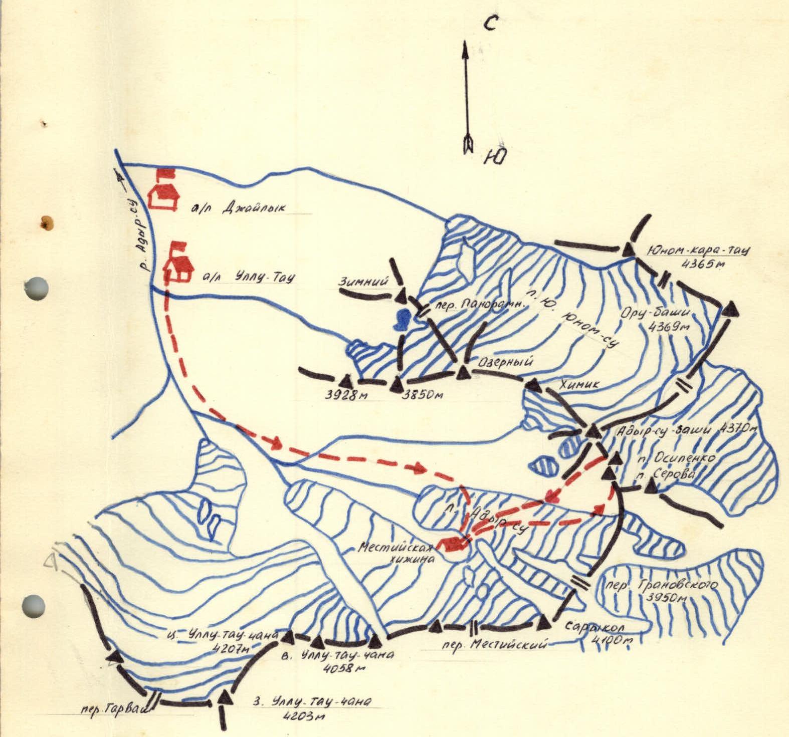
Ascent Area Map
Description of the approach to the route on Serov Peak via the southeast wall: Approximately 4B
From the Ullutau tourist camp, we follow the Mestia trail to the right-bank moraine of the Adyr-Su glacier.
From the moraine, we descend to the glacier, cross it, and, bypassing a rock tower on the left, reach the Mestia hut located on the tower. Overnight stay is possible here. The journey from the Ullutau tourist camp to the Mestia hut takes 2.5–3 hours.
From the Mestia hut, we descend to the Adyr-Su glacier and move along the center of the glacier towards the Granovsky Pass.
The route begins at the base of the couloir (the couloir running from the southern ridge of Adyr-Su) under the southeast wall of Serov Peak. Gradually crossing the glacier from right to left, we approach the southeast wall of Serov Peak.
Explanation for the table of route section characteristics (Appendix 2):
- On July 11, 1979, the group left the Ullutau camp at 11:00 and stopped for a bivouac at the Mestia hut at 14:00.
July 12, 1979. Departure from the Mestia hut at 4:00. Down to the Adyr-Su glacier and along the glacier (closed crevasses!) towards the Granovsky Pass, veering left, we reach the southeast wall of Serov Peak. From the Mestia hut — 1 hour. The route begins on the counterfort on the right, from which a large snowy couloir runs from the southern ridge to Adyr-Su-Bashi.
- Up the couloir for one rope length to a ledge leading to the crest of the counterfort.
- Along the ledge for three rope lengths to the crest and from the crest of the counterfort, left to right, into an internal angle.
- We pass a wall (climbing of moderate difficulty, loose rocks!).
- We reach ledges and along the ledges for one rope length to the internal angle.
- Further along the internal angle (ice, water), we reach under an overhanging plug for 3 rope lengths (pitons for belaying).
We pass the plug using artificial holds (8 m). Further along a wide internal angle, keeping to the right side, along rocks like "ram's foreheads" — two rope lengths to a wide platform under the wall. On the platform, there is a control cairn and possible overnight stay. From the start of the route, 4–5 hours.
From the control cairn:
- We approach the wall.
- Along an inclined smooth ledge running from right to left, we ascend for 1 rope length under overhanging yellow rocks at the end of the ledge.
Along complex overhanging rocks upwards for 4 m, then into a crack and along the crack, we approach under an overhanging wall for 3 m, which we bypass on the right and along a narrow chimney, exit onto a sharp ridge. The key section of the route.
Further along the ridge, along a smooth slab with few holds (15 m), we exit onto a narrow, gently sloping crest and along it for one rope length to overhanging blocks of the summit tower, which we bypass in traverse from left to right along несложные rocks in the direction of a snowy-ice couloir.
Along the couloir, adhering to the destroyed rocks on the right side, we exit onto a saddle under the summit on the 4A category route. From the saddle, left onto the summit — one rope length.
From the control cairn — 4 hours.
Characteristics of the route sections on Serov Peak via the southeast wall: Approximately 4B
| Date | Designation | Average steepness in degrees | Length in meters | Terrain characteristics | Difficulty | Condition | Weather conditions | Pitons for belaying | Pitons for creating artificial holds |
|---|---|---|---|---|---|---|---|---|---|
| rock | ice | ||||||||
| July 12, 1979 | R0–R1 | 45 | 120 | wide ledge | III | destroyed rocks | good | ledges | — |
| —"— | R1–R2 | 55 | 20 | wall | IV | —"— | —"— | 2 | ledges |
| —"— | R2–R3 | 25 | 60 | ledges | II | —"— | —"— | simultaneously | |
| —"— | R3–R4 | 45 | 80 | internal angle, water, ice | IV | monolith, loose rocks | —"— | 6 | III |
| —"— | R4–R5 | 80 | 8 | plug in internal angle, slab | V | monolith | —"— | 2 | — |
| —"— | R5–R6 | 30 | 80 | internal angle, slabs, water | III | monolith | —"— | 2 | — |
| —"— | R6–R7 | 25 | 20 | snow, slab | II | monolith | —"— | simultaneously | |
| —"— | R7–R8 | 30 | 40 | wide ledge | III | monolith | —"— | 2 | ledges |
| —"— | R8–R9 | 100 | 4 | wall, cornice | VI | monolith | —"— | — | — |
| —"— | R9–R10 | 60 | 36 | crack | IV | monolith | —"— | 3 | ledges |
| —"— | R10–R11 | 80 | 3 | wall | V | monolith | —"— | 1 | — |
| —"— | R11–R12 | 50 | 30 | chimney | IV | monolith | —"— | 1 | ledges |
| —"— | R12–R13 | 70 | 15 | ridge, slabs | IV | monolith | —"— | 2 | ledges |
| —"— | R13–R14 | 5–10 | 40 | ridge | III | monolith | —"— | — | ledges |
| —"— | R14–R15 | 40 | 120 | ledges, slabs | II | monolith | —"— | — | ledges |
| —"— | R15–R16 | 40 | 40 | couloir, snow, ice | III | destroyed rocks, snow, ice | —"— | — | ledges |
| —"— | R16–R17 | 50 | 30 | destroyed ridge | II | destroyed rocks | —"— | — | ledges |
| DESCENT ROUTE FROM THE SUMMIT | |||||||||
| —"— | R17–R18 | 20–30 | 140 | destroyed ridge | III | destroyed rocks | —"— | 2 | ledges |
| —"— | R18–R19 | 30–35 | 150 | III | destroyed rocks | —"— | 10 | — | |
| —"— | R19–R20 | 30–25 | 200 | couloir | II | snow, firn | —"— | simultaneously |
Descent via the 4A category route towards Osipenko Peak. After Osipenko Peak, descent is sporty to the saddle and from the saddle into the couloir. Along the couloir, six sporty descents, adhering to the right side, and further in traverse under the rocks to the right into a large wide couloir leading to the Adyr-Su glacier. Descent to the Adyr-Su glacier and along the glacier to the Mestia hut. The descent took 3–4 hours.
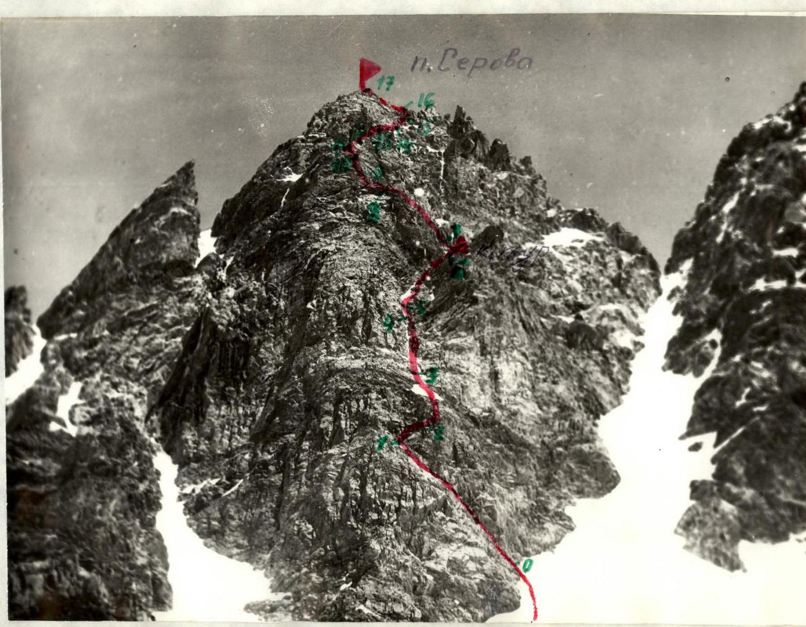
Photo of the general view of the route
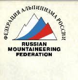
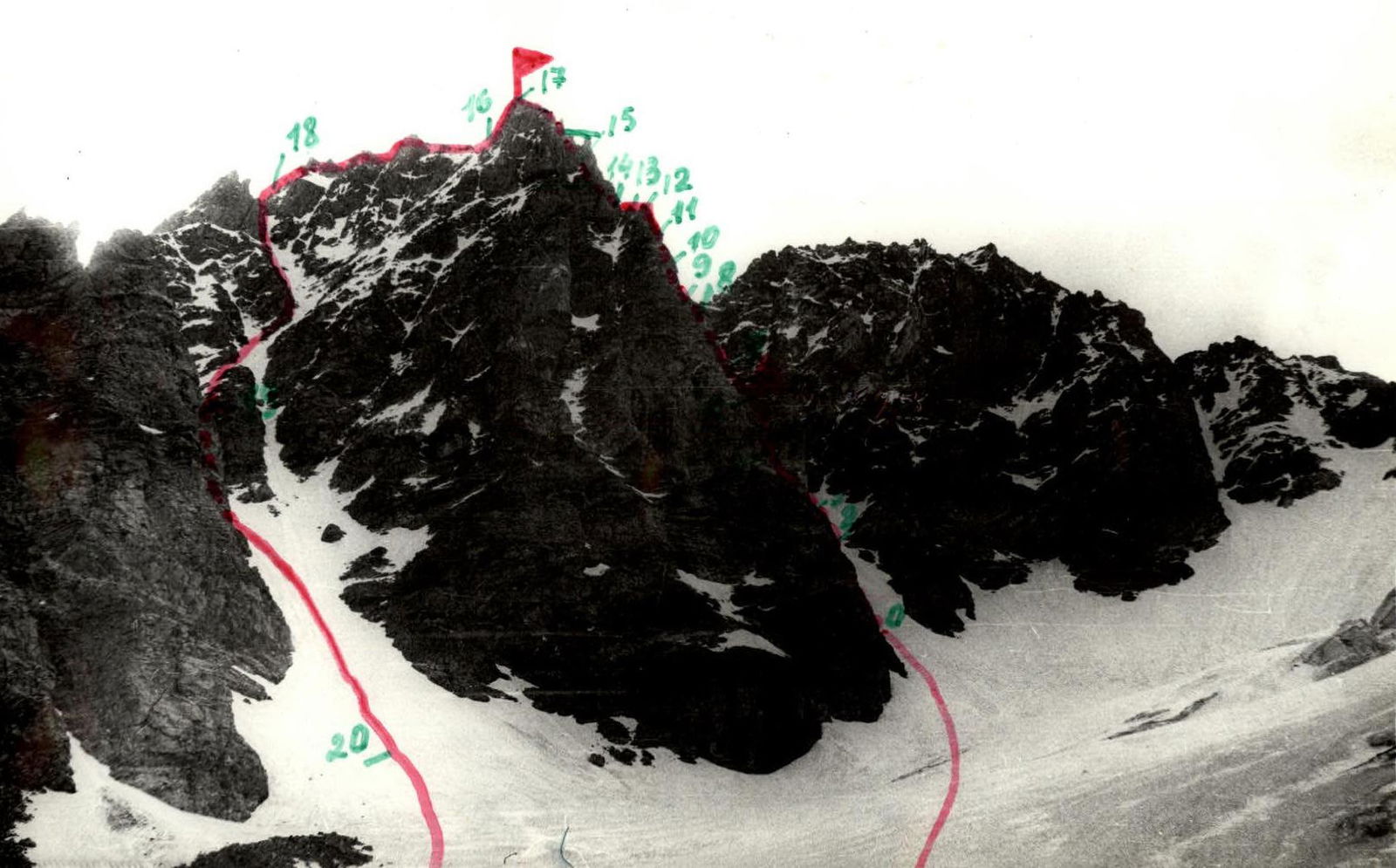
Photo of the route profile
Route sections:
- R8–R9
- R9–R10
- R10–R11
- R11–R12