
Russian Mountaineering Championship High-Altitude Technical Class
Ascent Report
To Shokoladny Peak (3650 m) via the Southwest Wall (R. Despie, 1975) 5B category, Rocky.
Team FANO
- Team Coach: Nikonov A.E. (1st sports category)
- Leader: Shurygin S.D. (1st sports category)
- Participants: Koroleva E.I. (1st sports category), Ryndyk A.P. (1st sports category)
Ascent Passport
- Region, gorge, section number according to the 2001 classification table:
Krasnodar and Stavropol Krais up to Marukh Pass
- Name of the peak, its height, route name:
Shokoladny Peak, 3650 m, via the Southwest Wall, Raymond Despie route
- Difficulty category: 5B
- Route type: rocky
- Height difference of the route: 750 m
Height difference of the wall section: 500 m. Route length: 800 m Length of sections:
- 5th category – 350 m.
- 6th category – 85 m. Average steepness:
- main part of the route — about 85°
- entire route — about 70°
- Number of pitons left on the route: none left
Number of pitons used on the route: Total number of artificial holds (ATC) — ATC not used
| Camalots | 74 |
|---|---|
| Anchor pitons | 11 |
| Bolts | 5 |
| Total | 90 |
- Team's working hours: 9.5 hours, 1 day
- Leader:
Shurygin Sergey Dmitrievich, 1st sports category. Participants:
- Koroleva Eva Igorevna, 1st sports category.
- Ryndyk Alexander Pavlovich, 1st sports category. Coach: Nikonov Alexander Evgenievich, 1st sports category.
-
Departure to the approach: August 29, 2020, 14:30
-
Start of the ascent: August 30, 2020, 06:30
Reached the summit: August 30, 2020, 16:00. Returned to the tents: August 30, 2020, 17:50. Returned to the Base Camp: August 30, 2020, 22:00
- Organization: FANO, Nizhny Novgorod
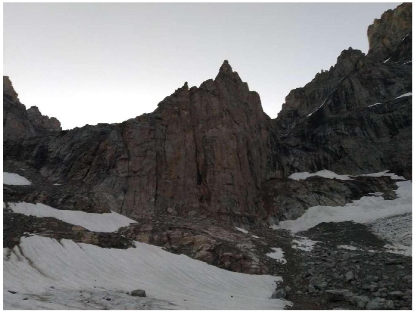
- Person responsible for the report: Shurygin Sergey Dmitrievich, phone +7 962 514-26-23, serg.shur1995@gmail.com. General photo taken from the bivouac
 Technical
photo of the route (with section indications)
Technical
photo of the route (with section indications)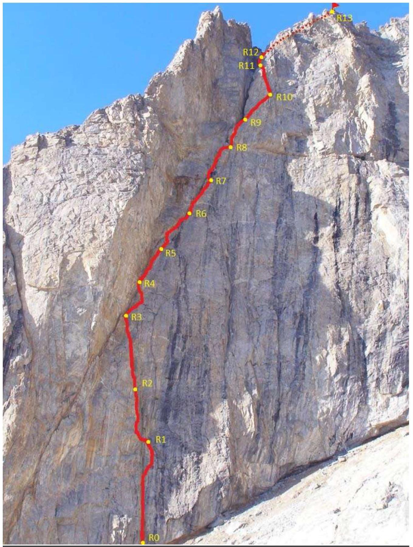
Route Diagram in UIAA Symbols:

Route Description by Sections:
R0–R1 (35 m, 90° 6, 20 m, 90° 5+) Upwards along the left side of the vertical inner corner under the overhang, bypassing it on the left. Then move to the right side of the corner and proceed to the ledge R1. R1–R2 (5 m, 5, 85°, 50 m, 85° 5+) From station R1, traverse left, then return to the inner corner via slabs. R2–R3 (60 m, 85° 5+) Move up the inner corner to a system of ledges, the last of which is station R3. R3–R4 (35 m, 85° 5+) Along the right side of a huge inner corner to a small inclined ledge. R4–R5 (6 m, 80° 5+, 35 m, 80° 5+) Traverse right, then up and left to a ledge in the center of the chimney. R5–R6 (15 m, 90° 6, 25 m, 90° 5) Move up the center of the chimney to a station on an inclined ledge. R6–R7 (35 m, 80° 5) Move up the center of the chimney, first in the center, then on the right, station on the right on a ledge. R7–R8 (40 m, 85° 5) Continue moving up the right side of the chimney-crack to a station under an overhang. R8–R9 (40 m, 90° 5+) On the right side, and then in the center, approach the base of a characteristic huge black crack. Station is to the right of its beginning. R9–R10 (45 m, 80° 4+) Move right-up along an oblique ledge to a "live" plug, after which is the station. R10–R11 (35 m, 85° 6) Up the center of the inner corner to a cornice, bypass it on the left and reach a flat ledge. R11–R12 (35 m, 45° 3) Traverse to a convenient ledge in a scree gully. R12–R13 (80 m, 45° 3, 200 m, 30° 2) From the ledge, ascend simple rocks to a saddle, then right along the ridge to the summit.
Descent from the summit via simple rocks and snow-scree slopes towards Malaia Trapezia, then down snow-scree slopes to the original bivouac on the Zapadny Dalar glacier.
The route begins on the right side of the SW wall of Shokoladny Peak, practically under the West wall of Dalar Mt.
The start time on the route should not be later than 7:00, as after 10:00, when the sun illuminates the wall, the first two ropes of the route are exposed to rockfall from Dalar.
Section R0–R3. The beginning of the route goes through a vertical inner corner with cornices and narrow overhangs. At the start of the route, a bolt was once hammered, but now only a hole remains. According to old descriptions, it's a 4-pitch section, but with 60-meter ropes, it can be reduced to three, which our team did. The first ropes of the route are easy to read, with bolts and pitons at the stations, and there are loops. The rocks are monolithic. The corner connects to an oblique crack at the first third of the wall. At the junction, there's a platform for a tent R3. This is the only comfortable bivouac spot on the route. Further bivouacs are either:
- sitting
- hanging
Section R3–R5. The center is "alive," bypassed on the right on section R3–R4 (2–3 m from the center of the corner) along smoothed monolithic walls. From R3 to R10, there are many loose rocks. From station R3, right-up along the crack, the route is unambiguous.
Section R5–R9. Many loose rocks. In rainy weather, the route goes through a waterfall. In good weather, water flows down the chimney walls. Movement through difficult rocks to R9 is mostly free climbing on the right side of the wet chimney-crack.
Section R9–R11. Station R9 is on an oblique ledge (avoid the gully, it's rockfall-prone), then bypass the plug and continue left-up along the overhanging wall. It's more convenient to set up a station after the plug — several bolts are hammered. On section R10–R11, there are no loose rocks. The most challenging climbing (key section) is the overhanging wall with cornices. Setting up a tent is possible at station R11.
From R11, traverse left into a snow-scree gully, ascend to a saddle on the pre-summit ridge. Then, along a 200-meter rocky section, ascend to the summit.
Route Timeline and Weather Conditions:
- August 29, 2020, 14:30 — Departure to the bivouac from AUSB "Uzunkol"
- August 29, 2020, 18:30 — Setting up camp at the bivouac
- August 30, 2020, 04:00 — Wake-up
- August 30, 2020, 05:00 — Departure to the route
- August 30, 2020, 06:30 — Start of work on section R0–R1
- August 30, 2020, 09:15 — Station R3, first key section completed
- August 30, 2020, 15:00 — Station R11, second key section completed
- August 30, 2020, 16:00 — Summit
- August 30, 2020, 16:10 — Start of descent
- August 30, 2020, 17:50 — Return to the bivouac
- August 30, 2020, 19:00 — Start of descent to the base camp
- August 30, 2020, 22:00 — Return to AUSB "Uzunkol"
Weather Conditions: favorable before and during the ascent. On the morning of August 30, clear, after noon clouding over, no precipitation. Every evening after 18:00, everything is shrouded in fog, which should be taken into account when planning the ascent, as descent from the summit in fog is challenging.
Tactical Actions of the Team: On August 29, 2020, at 14:30, the team departed to the bivouac on the Zapadny Dalar glacier, set up camp at 18:30. In the morning at 5:00, they departed from the bivouac and approached the start of the route at 6:10, the leader began moving at 6:30. The movement pattern: the leader with a small backpack moved on a double rope, set up top-rope protection, and received the other two participants with backpacks. All team members moved with free climbing, no ATC was used. The jumar taken was not needed. The leader, Ryndyk A.P., completed the entire route. According to available descriptions, there are 4 ropes to the chimney, which is the main part of the route. Our team reduced the number to three, which is possible with 60-meter ropes. At 9:15, they reached the start of the chimney-crack. The center is destroyed, with many loose rocks throughout, requiring attention. Movement was mostly on the right part of the chimney. At 14:00, they overcame the chimney section, the crack-chimney continues further to a saddle. It's not worth climbing it: many loose rocks and water flows — further, according to the description, traverse along ledges to the right. At 15:00, they overcame the main part of the route, then traversed and simple but heavily destroyed rocks, be careful! From the saddle, along an obvious, simple, and safe path, they reached the summit at 16:00. Descent towards Malaia Trapezia, stay to the right, left are rockfall-prone areas, the final part of the descent to the snowfield goes through a narrow scree gully. Then, along the snowfield and scree, they returned to the bivouac at 17:50, packed up, and returned to the alpine camp at 22:00.
A pleasant rocky route, no problems with protection. Orientation is simple, the line of movement is logical, the main thing is not to deviate from it and not stray from the chimney. At the stations, there are old bolts.
In rainy weather:
- the route goes through a waterfall
- rocks fall.
The team completed the route according to the tactical plan, worked in harmony and clearly, without failures.
Equipment Used on the Route:
- Dynamic rope 9.2 mm (60 m) – 2 pieces
- Anchor pitons – 6 pieces
- Rock hammer – 3 pieces
- Camalots – 13 pieces
- Station loops – 2 pieces
- Quickdraws – 13 pieces
- Screwgate carabiners – 12 pieces
- Jumars – 2 pieces
- Crampons – 3 pairs
- Ice axes – 3 pieces
- Backpack – 3 pieces
- Repschnur – 15 m.
- Tent – 1 piece in case of bad weather
- Camping mat – 1 piece
- First aid kit – 1 piece
Photos from the ascent:
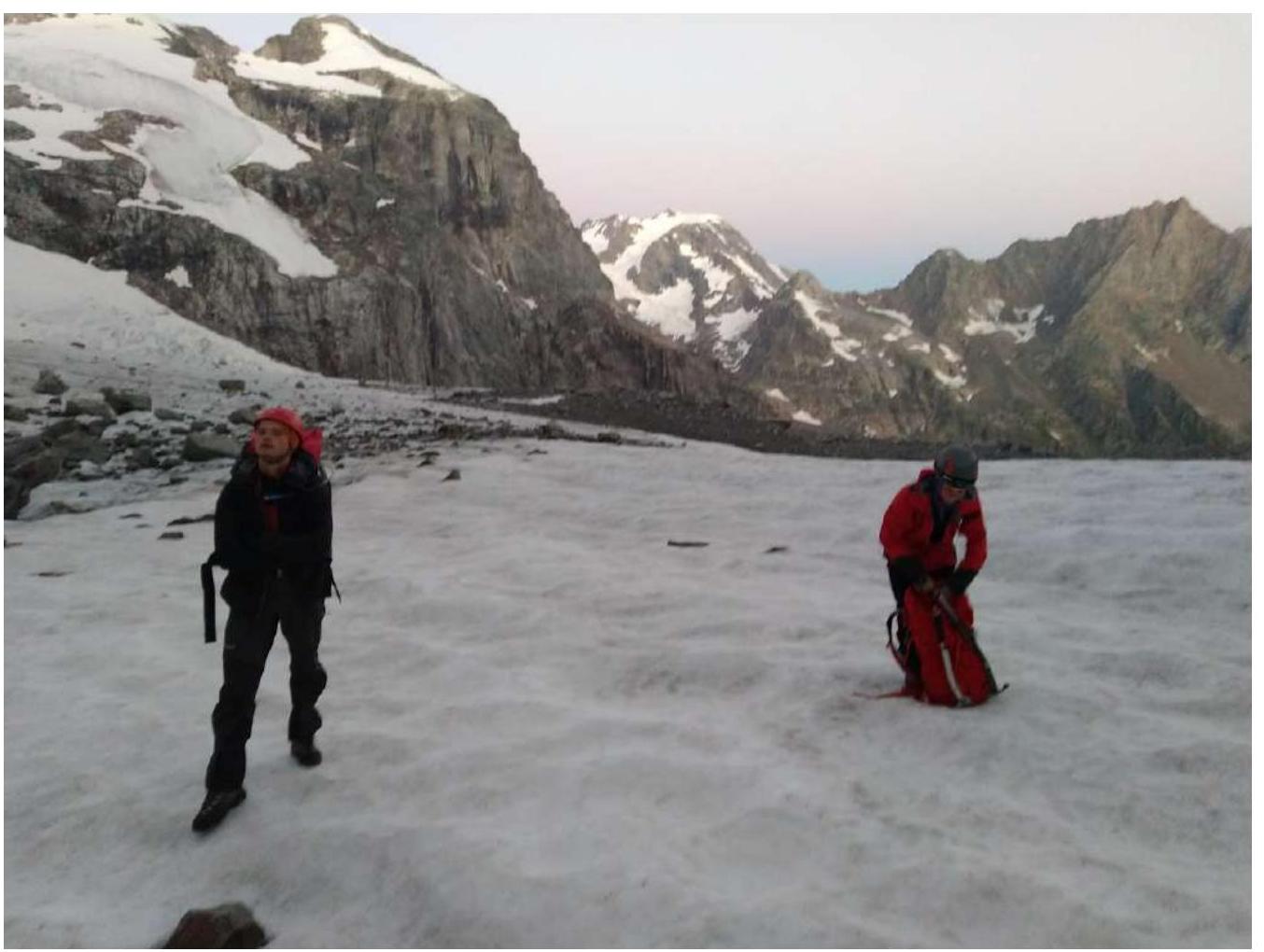
Approach to the start of the route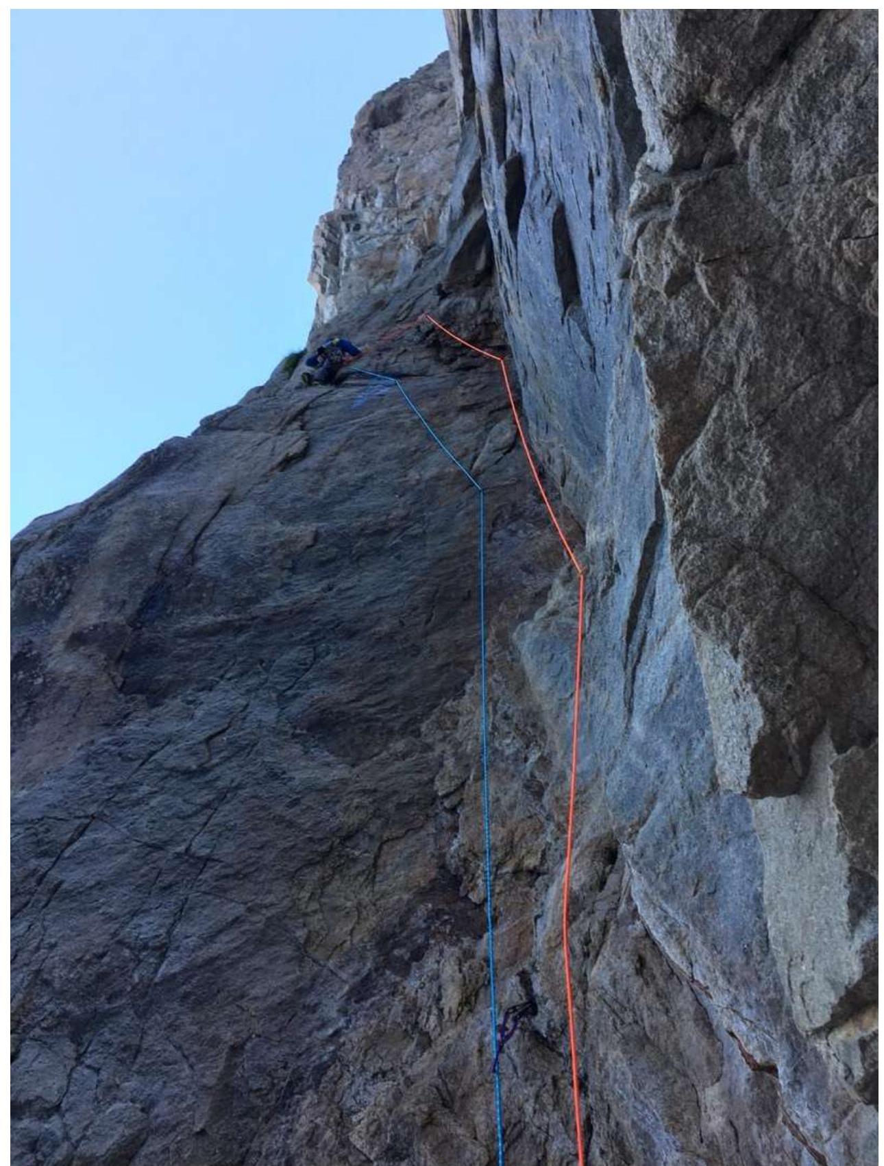
Leader's work on section R0–R1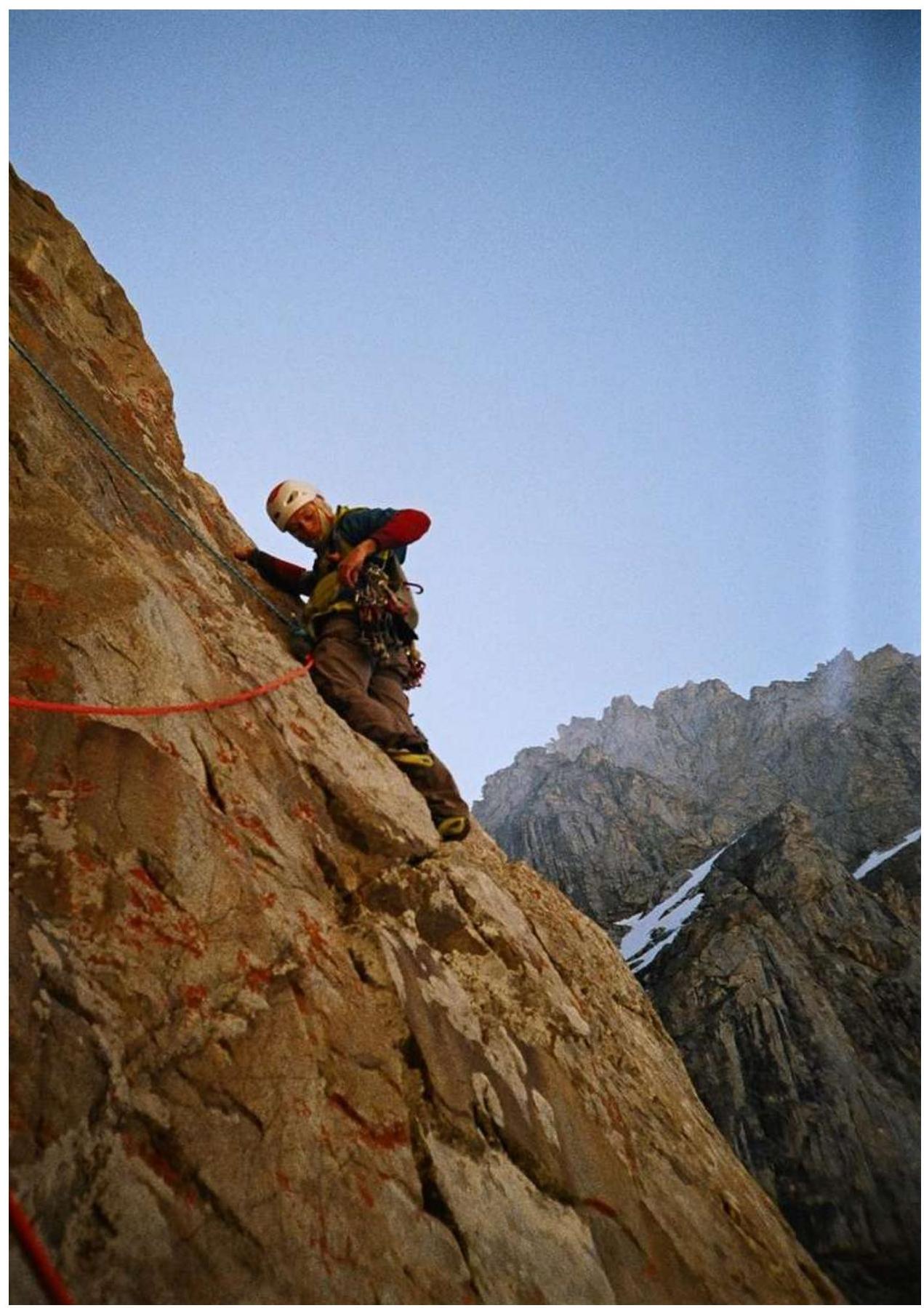
Leader's work on the traverse at the start of section R4–R5
Leader's work on section R11–R12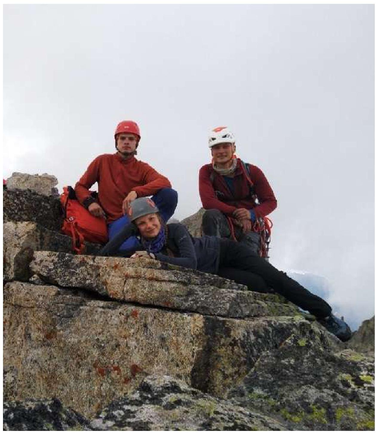
Team at the summit
Comments
Sign in to leave a comment