Sports team of Voroshilovgradkhimstroy complex Uzunkol alpine camp
REPORT
on the first ascent to the Shidag-Mingen peak via the northern ridge, category 3B, on July 27, 1980 Severodonetsk
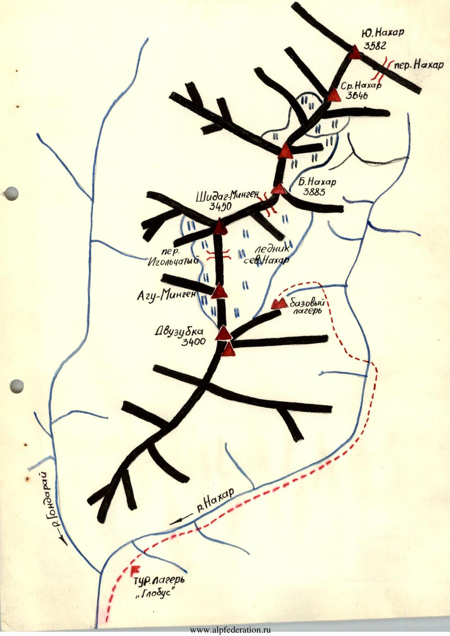 From the bivouac on the moraine in the cirque of B. Nakhar and Dvuzubka peaks, along the moraine ridge on the left side of the North Nakhar glacier, then ascent to the right and upwards along the glacier to the bergschrund under the couloir leading to Igolchaty pass. 1 hour from the overnight stay. Cross the bridge from right to left (belay), exit to simple rocks and along the talus shelf - under the overhangs on the left side of the couloir. Under the overhangs, along the boundary of rocks and snow, ascent to the start of a 20m 60° chimney. Up the chimney (rocks! pitons!) and then along the 40m 45° inclined slabs (belay), exit to the talus couloir. 200m along the couloir - simultaneous movement - from left to right towards the snow and then 40m upwards along the rocks like "sheep's foreheads" (belay! pitons!). Exit under the finger on the pass (convenient bivouac spot) and then to the pass. This is the I control point. 2 hours from the bergschrund.
From Igolchaty pass, along the left side of the wall, 20m 80°, exit to a shelf. From the shelf straight up along a 7m 90° chimney and then along an inclined crack under the overhangs (difficult climbing), exit to a narrow (0.5m) horizontal shelf - 10m under the overhangs (careful belay!). At the end of the shelf is the II control point.
Then along a wide 20m talus shelf and left-upwards along the rocks of medium difficulty like "sheep's foreheads" 40m, exit to the ridge. From the left, along a narrow 20m grassy shelf, approach under the rusty wall with a steepness of 80°. Along the left part of the wall - 40m, exit to a shelf.
20m along the crack and then upwards along the ridge, sticking to its left side, approach the inner corner. Along the 20m inner corner - exit to a 10m talus shelf under the rocks.
Along the 40m rocks - exit to a 50m gap in the ridge. 10m abseil to a large inclined shelf. From the shelf, a 40m diagonal abseil to the right to the col.
5m up from the col - III control point.
 Further ascent along the 40m 60° rocks - exit to a shelf before the couloir leading towards North Nakhar glacier. From the shelf, 80m along simple rocks (belay on the ledges) exit to the summit. 8 hours from Igolchaty pass.
Descent is done via the ascent route to the cirque of B. Nakhar and Dvuzubka peaks. 5 hours to the bivouac.
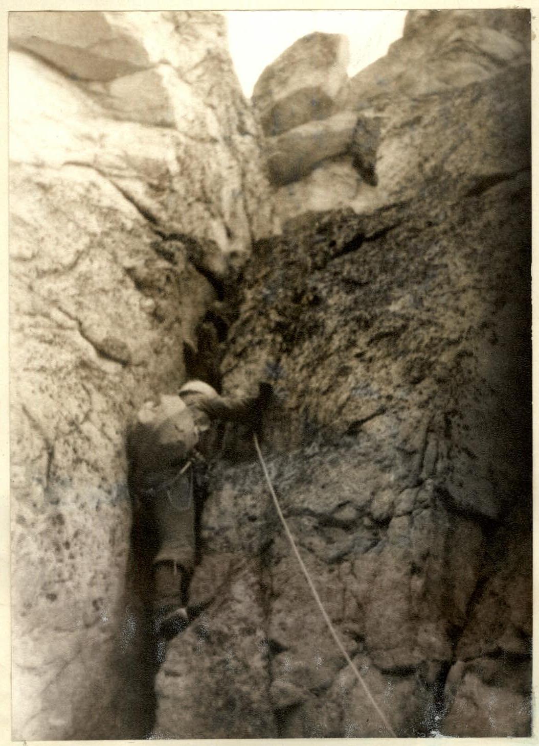 Section R12-R13. Passing a 7m chimney.
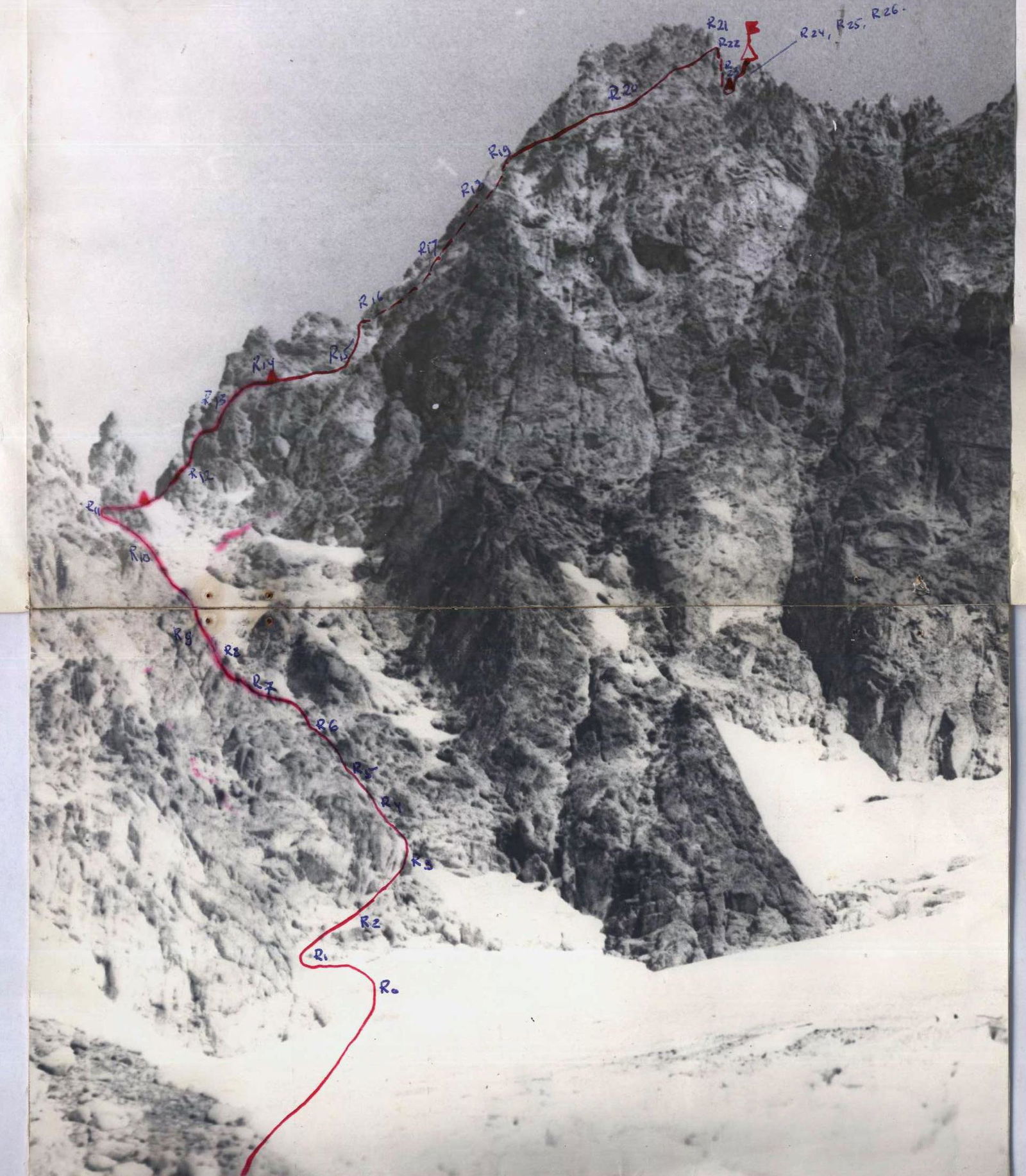
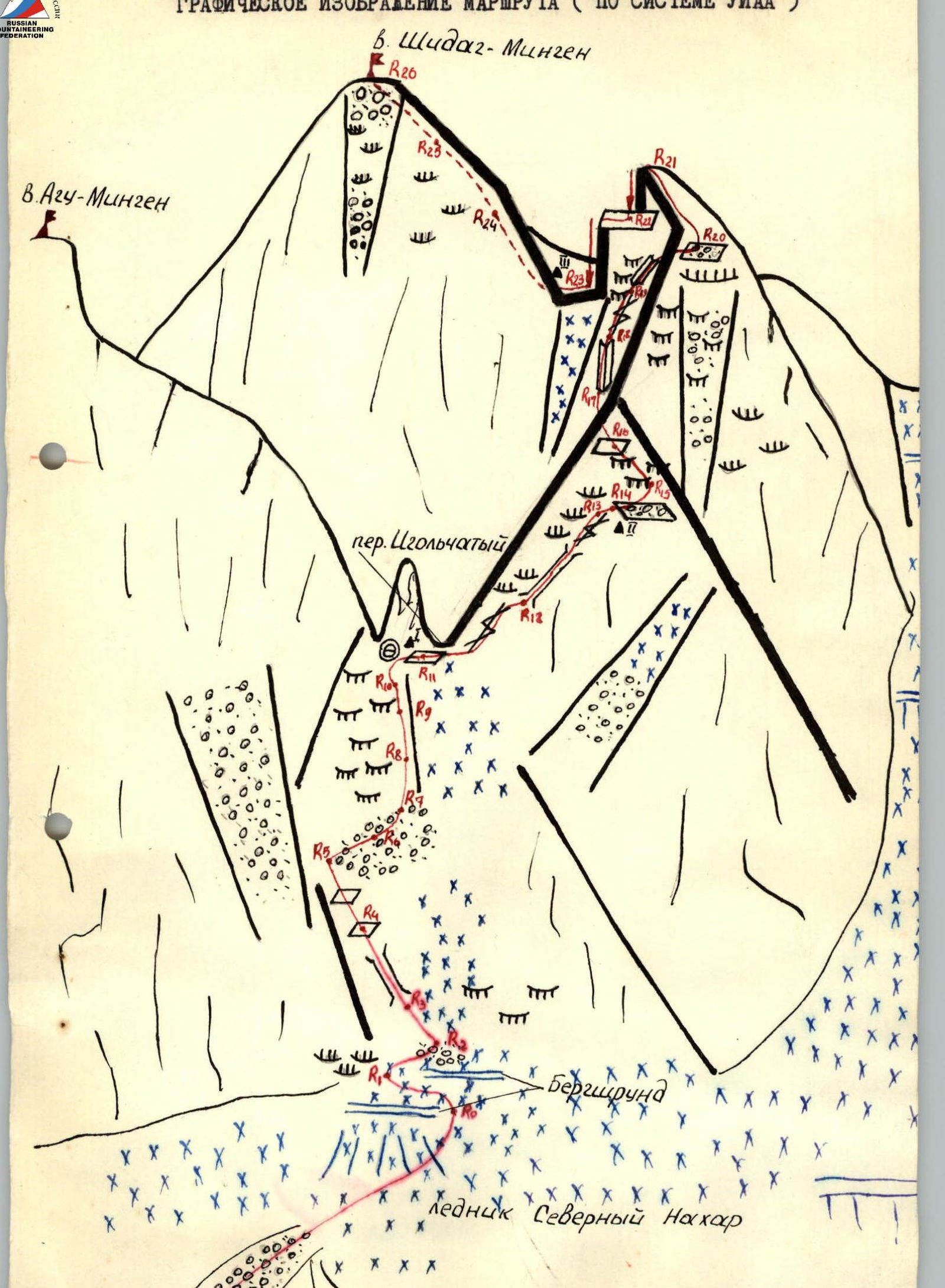
GRAPHICAL REPRESENTATION OF THE ROUTE (ACCORDING TO THE UIAA SYSTEM)
Brief characteristics of the sections
Moraine - R0 - approach to the bergschrund on snow (30°). Section R0-R1 - pass the bergschrund from right to left under the rocks (belay). Section R1-R2 - 40m along the talus shelves (rocks). Section R2-R3 - pass the couloir on the left along the boundary of rocks and snow (piton belay! rocks!). Section R3-R4 - tense climbing along the chimney, then along the rocks (belay, pitons). Section R4-R5 - movement along the 40m 60° inclined slabs. Section R5-R8 - simultaneous movement along the talus. Section R8-R9 - passage along the 40m slabs like "sheep's foreheads". Section R9-R10 - exit under the wall of Agu-Mingen peak. Section R10-R11 - traverse along the wall, bypass the finger on the right, exit to Igolchaty pass (I control point). Section R11-R12 - from the shelf straight up along a 20m 80° crack, tense climbing. Section R12-R13 - initially a 7m 90° chimney (very difficult), then right-upwards along a 33m crack. Section R13-R14 - traverse along a 10m horizontal shelf 0.5m wide (II control point). Section R14-R15 - passage along a 20m wide talus shelf. Section R15-R16 - then along the rocks like "sheep's foreheads" (belay). Section R16-R17 - transition to the left side of the ridge along a 20m grassy shelf under the rusty wall with overhangs. Section R17-R18 - 40m 80° along the inner corner of the wall (rocks!). Section R18-R19 - 20m 65° along the crack, then movement along the ridge (slabs on friction) 20m. Section R19-R20 - from the shelf upwards, first along the blocks, then along the 20m 60° inner corner. Section R20-R21 - exit to the top of the ridge to a 50m gap. Section R21-R22 - from the ridge down 10m abseil to an inclined shelf. Section R22-R23 - from the left part of the shelf, abseil to the right to the opposite side of the gap 40m (throws off!) (III control point). Section R23-R24 - 20m along the inner corner, then 20m along the rocks. Section R24-R25. Section R25-R26 - simultaneous movement to the summit 80m (belay on the ledges).

| Date | Designation | Average steepness, ° | Length, m | Relief character | Difficulty | Condition | Circumstances | Rock difficulty | Ice difficulty | Belay difficulty |
|---|---|---|---|---|---|---|---|---|---|---|
| 27.07. | R0-R1 | 45 | 40 | snow | good | with ice axe | ||||
| 27.07. | R1-R2 | 45 | 40 | snow-rocks | 2 | destroyed | with ice axe | |||
| 27.07. | R2-R3 | 45 | 30 | couloir | 2 | destroyed | on ledges | |||
| 27.07. | R3-R4 | 60 | 40 | chimney, rocks | 3 | monolithic | 3 | |||
| 27.07. | R4-R5 | 60 | 40 | inclined slabs | 3 | monolithic | 3 | on ledges | ||
| 27.07. | R5-R6 | 45 | 40 | talus | 2 | destroyed | simultaneous | |||
| 27.07. | R6-R7 | 45 | 40 | -"- | 2 | -"- | -"- | |||
| 27.07. | R7-R8 | 45 | 40 | -"- | 2 | -"- | -"- | |||
| 27.07. | R8-R9 | 60 | 40 | rocks like "sheep's foreheads" | 3 | monolithic | 2 | |||
| 27.07. | R9-R10 | 45 | 40 | talus | 2 | destroyed | simultaneous | |||
| 27.07. | R10-R11 | traverse | 40 | boundary snow-rocks | 2 | 1 | ||||
| 27.07. | R11-R12 | 80 | 20 | crack in the wall | 4 | monolithic | 3 | |||
| 27.07. | R12-R13 | 90 | 7 | chimney | 4 | -"- | ||||
| 27.07. | R12-R13 | 65 | 33 | crack | 4 | -"- | 2 | |||
| 27.07. | R13-R14 | traverse | 10 | horizontal shelf | 2 | -"- | 1 | |||
| 27.07. | R14-R15 | -"- | 20 | talus shelf | 1 | talus | ||||
| 27.07. | R15-R16 | 60 | 40 | slabs like "sheep's foreheads" | 3 | monolithic | 1 | |||
| 27.07. | R16-R17 | traverse | 20 | grassy shelf | 1 | destroyed | on ledges | |||
| 27.07. | R17-R18 | 80 | 40 | inner corner of the wall | 2 | semi-destroyed | 3 | |||
| 27.07. | R18-R19 | 65 | 40 | crack, edge | 2 | destroyed | 2 | |||
| 27.07. | R19-R20 | 60 | 20 | inner corner | 3 | monolithic | good | 1 | on ledges | |
| 27.07. | R20-R21 | 30 | 40 | rocks like "sheep's foreheads" | 3 | monolithic | 1 | on ledges | ||
| 27.07. | R21-R22 | 90 | 10 | abseil | 1 | - | 1 | on ledge | ||
| 27.07. | R22-R23 | 90 | 40 | abseil | 1 | - | 3 | |||
| 27.07. | R23-R24 | 60 | 40 | rocks | 2 | semi-destroyed | 2 | on ledges | ||
| 27.07. | R24-R25 | 50 | 40 | slabs | 2 | monolithic | on ledges | |||
| 27.07. | R25-R26 | 50 | 40 | slabs | 2 | monolithic | -"- |