Report on the First Ascent to v. Zamok from the Northwest (Training Gathering of the Central Council of the LOKOMOTIV Sports Society)
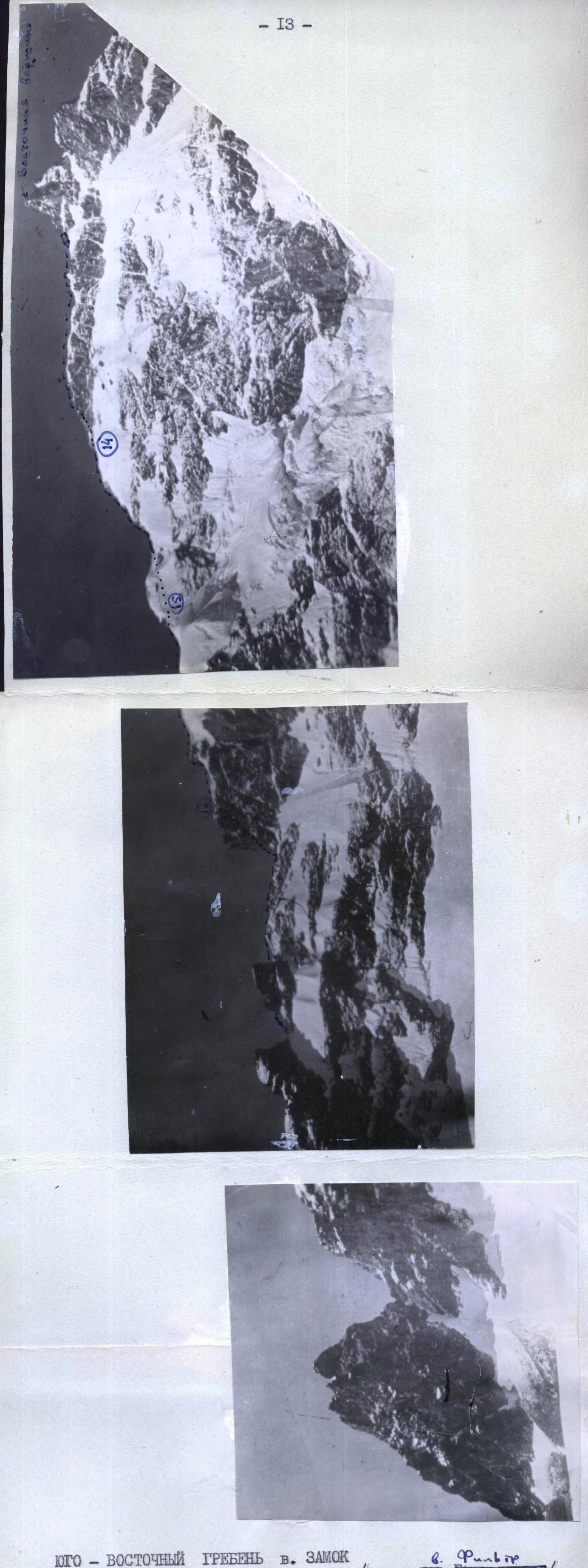
Southeast Ridge of v. Zamok
(View from v. Burevestnik)
View of v. Zamok from the ridge of v. Dolomit. The route of the first ascent to v. Zamok from the northwest wall.

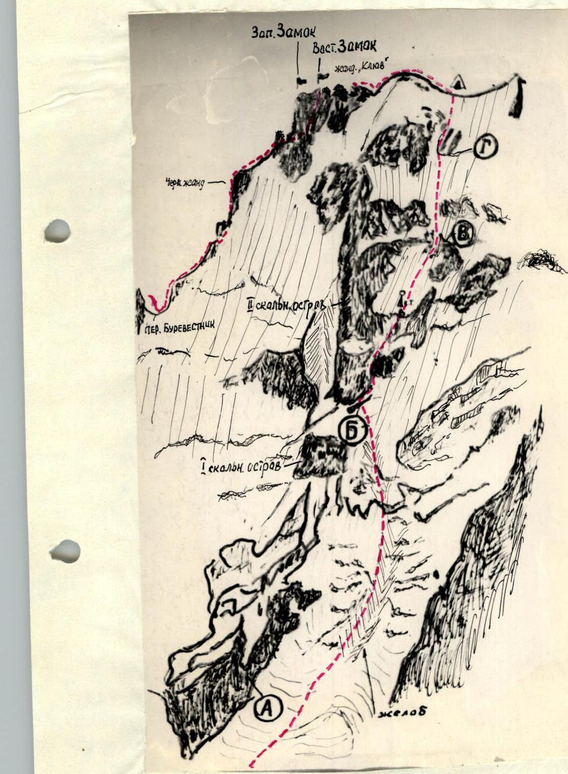 Photo # 2. View of Zamok peak from Dalar peak.
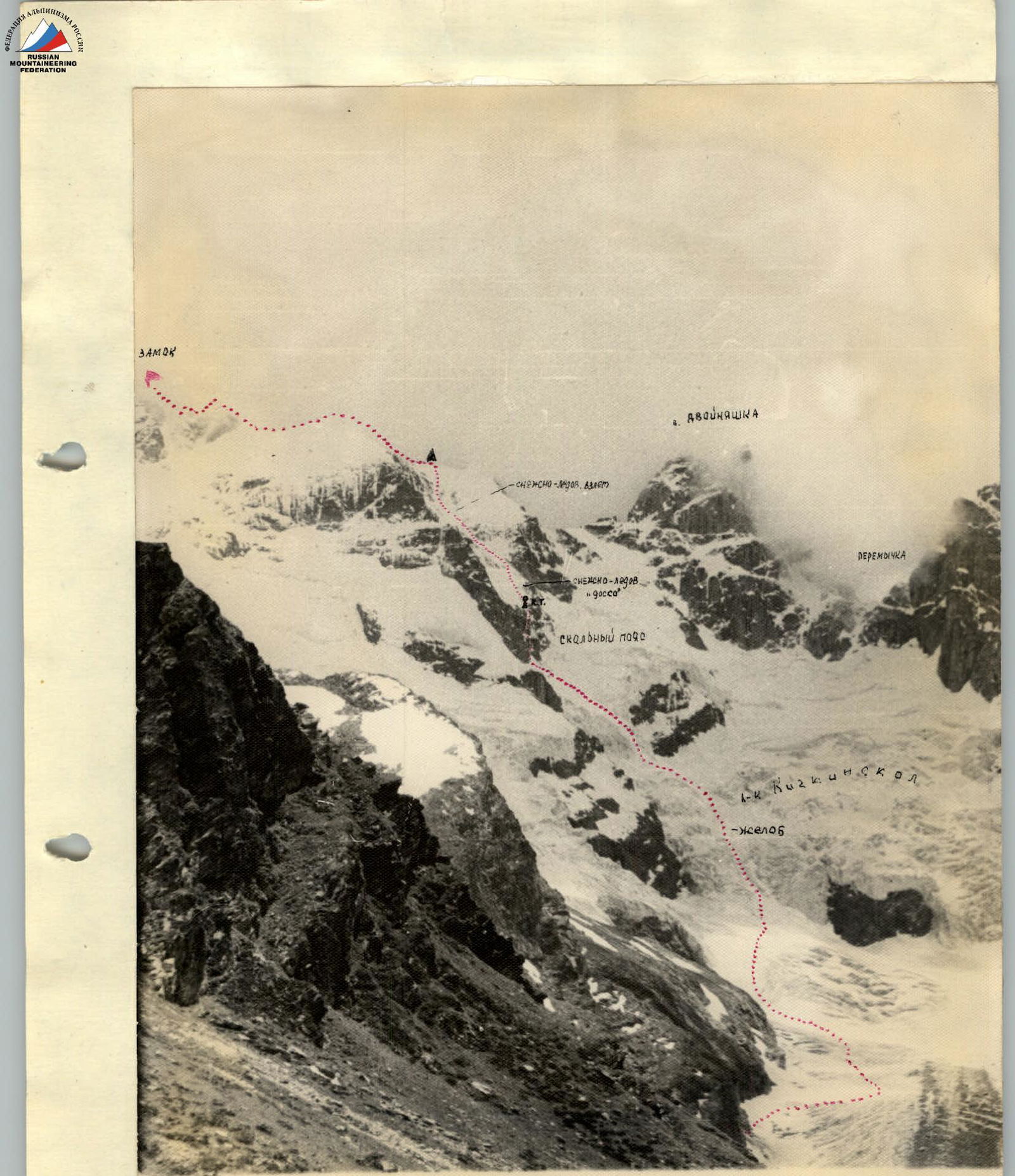
July 25, 1967: FIRST DAY. From the Uzunkol alpine camp along the left bank of the river to the bridge, and further along the right bank of the Uzunkol river to the stream flowing from the Sredny Kichkinokol glacier. To the left of the stream to the ice campsite on the lateral moraine of the Bolshoy Kichkinokol glacier. July 26, 1967: SECOND DAY. From the campsite, the path goes along the moraine and then along the Bolshoy Kichkinokol glacier, oriented towards the steep ice gully to the right of the lower rock island of the northern counterfort of v. Zamok. The path from R0 to R2 from the campsite on the moraine to the gully takes 1 hour 30 minutes. The average steepness of the snow-ice slopes when approaching the gully is 30°. Before entering the gully, we tied up in the following order: first rope — Likhachev Y.V. — Aptekman V.D. second rope — Manshin Y.M. — Keidan V.F. Further along the gully, sticking to its left side, 300 m upwards (average steepness 35°–40°, on crampons) (3) — to a steep ice slope between the first rock island (A) (photo 2) and the icefall. Along the ice slope (4) straight up 100 m (steepness 45°–50°) with piton belay. Then along the snow-ice slope (5), with a steepness of 35°–40°, bypassing the bergschrund, exit to a rock shelf (B) (photo 2) under the second rock island — 300 m (belay). This snow-ice section up to the rock shelf (5) was first passed by the first rope. The path from the campsite to the shelf takes 4–5 hours. A campsite can be organized on the shelf.
From this shelf, traverse to the right along the edge of rocks and ice — 40 m, piton belay, to the couloir between the northern counterfort and the large rock island. Up the couloir, sticking to its left side — 30 m to a shelf at the base of a rock wall with a cleft. Medium climbing, (piton) (6). Then up to the left along the cleft 10 m, exit to a shelf covered with ice, along which straight up 10 m along destroyed rocks with ice (piton), then, bypassing to the right upwards overhanging rocks like "ram's foreheads," 5 m — exit to a rock shelf (piton belay). This 25 m section is passed with difficult climbing (step 1) (7).
 From the shelf along the snow ridge 30 m to an inclined shelf at the base of a sheer wet wall (8). This section of the route from the lower shelf to the shelf with ice was first passed by the Manshin — Keidan rope. Then along the shelf to the right upwards 40 m (belay through ledges) to a chimney filled with ice. Up the chimney (9) 20 m, difficult climbing (step 2), piton, from it exit to the second shelf, filled with ice. Then along this, narrowing to nothing, shelf, 60 m to the right upwards under the sheer rock wall to a vaguely expressed ice gully with rock inclusions (piton belay). Transition from the shelf through the ice gully to the right side — 4 m under the rock wall (10) (piton) like "ram's foreheads," covered with ice, with a small number of holds. Up the wall straight up 3 m (the first goes with a sit) to an ice slope with a steepness of 30°–35°, along it 10 m straight up to a rock ledge (piton). See step 3. On this rock ledge, a control cairn (11) (See photo 2). The section of the inclined shelf, including the ice chimney, was passed by the 1st rope, and then up to the exit to the snow-ice slab — the second rope. The path from the rock shelf at the base of the second rock island to the control cairn takes 4–5 hours. From the ridge of the northern counterfort, the control cairn is located to the right at a distance of about 300 m. Traversing to the left to the ridge is impossible due to the extreme difficulty of the rocks, snow-covered and covered with ice, and there is also a great danger of cutting the snow-ice slope.
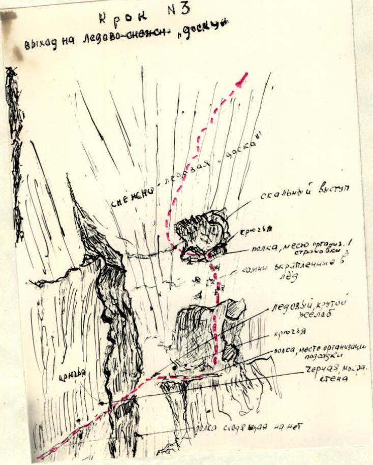
Further up to the left 20 m, bypassing rock outcrops on the ice slope, and then to the right upwards 200 m along a snow-ice slope with an average steepness of 45°, oriented towards the lowering of the rock ridge crossing the slope (12). Belay through ice piton. The ice is dense, местами covered with firn snow. Passage through the rock ridge along the ice slope (13) 40 m long, steepness 50° with careful belay on ice piton. Then along the snow-ice slope with a steepness of 45° upwards 80 m, bypassing to the left a rock island (B), with belay through ice piton. Further up along the snow-ice slope (14) with a steepness of 50°, 250 m with piton belay, oriented towards the beginning of the left rock island (C) in the wide part of the ice couloir. The steepness of the ice slope (15) before exiting to this rock island reaches 50°–55°. Careful belay when exiting to the rocks through piton. From here upwards, to the left of the island to the next rock ledge — 40 m (piton belay). The steepness of the ice slope (16) when bypassing this rock ledge — 55°–60°, 40 m. Then to the right upwards along the ice slope (17) with a steepness of 45° and a length of 40 m to the next rock ledge (piton). And further along the slope with a steepness of 30°, 20 m — exit to the main ridge of v. Zamok. A good campsite (for one or two tents). The ropes moved along the ice slope, interacting with each other. From the control cairn to the exit to the main ridge of the peak — 5–6 hours.
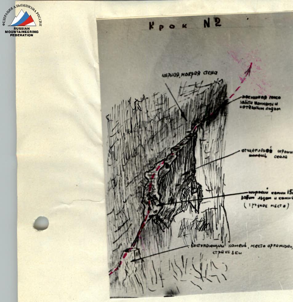
July 27, 1967: THIRD DAY: From the campsite, the path goes along the snow-ice ridge (20) with a series of ascents and descents to a steep rock drop.
 ![img"10.jpeg"{"width":516,"height":902,"format":"Jpeg","uri":"https://summitx.info/media/1/BfO0EmvHcBT8Yb1J3Al2LIwtICuCZh94/img-10.jpeg","id":64745380↗})
Down on a rope 20 m, then continue the descent with climbing for another 30 m. Ascent to the "Klyuv" pinnacle — first simple climbing, and then from an internal corner from under an overhanging wall to the right upwards (using a ladder) along a cantilevered rock to a crack going to the left upwards, then along this crack 8–10 m to an overhanging wall and under it traverse to the right to a platform 6–8 m (22). Climbing is extremely difficult without a backpack, with subsequent pulling. See photo 3 and step 4. This section was passed first by the 1st rope.
![img"10.jpeg"{"width":516,"height":902,"format":"Jpeg","uri":"https://summitx.info/media/1/BfO0EmvHcBT8Yb1J3Al2LIwtICuCZh94/img-10.jpeg","id":64745380↗})
Down on a rope 20 m, then continue the descent with climbing for another 30 m. Ascent to the "Klyuv" pinnacle — first simple climbing, and then from an internal corner from under an overhanging wall to the right upwards (using a ladder) along a cantilevered rock to a crack going to the left upwards, then along this crack 8–10 m to an overhanging wall and under it traverse to the right to a platform 6–8 m (22). Climbing is extremely difficult without a backpack, with subsequent pulling. See photo 3 and step 4. This section was passed first by the 1st rope.
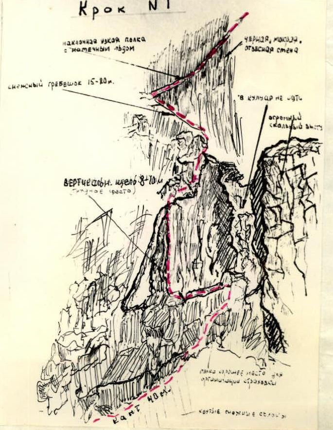
Further along the path, the route goes along simple rocks upwards along the ridge, not reaching 40 m to the top of the "Klyuv" pinnacle, descend to the right along an internal corner and traverse along an inclined shelf below the ridge to a saddle under the western peak (22) — 50 m. Bypass of the peak (23) to the right along a shelf — 40 m, right under the notch. Then ascent to the right upwards to a chimney with live rocks — 20 m, piton; further along the chimney — 15 m to a shelf. From the shelf to the left upwards under the overhanging wall along inclined slabs — 15 m, piton, and then upwards along the walls to the exit to the notch — 20 m (24), piton, step 5. This section was first passed by the Manshin — Keidan rope.
Descent to the saddle between the western peak and the notch with simple climbing and from there along a 10-meter rock wall (25) exit to the western peak of Zamok (difficult climbing, piton, ladders) — see step 6. From the peak straight along the ridge to the saddle between the eastern and western peaks — 40 m, campsite for one tent.
July 28, 1967, FOURTH DAY:
- From the campsite — 20 m along the ridge to the saddle.
- From it — 60 m along simple rocks exit to the eastern peak.
- Descent along the ascent route to the saddle.
- The rest of the day was spent hiding from bad weather.
Weather conditions:
- Sleet
- Thunderstorm
July 29, 1967, FIFTH DAY:
- Descent from the peak along the route 3B cat. sl. to the Burevestnik pass.
- The descent was greatly complicated by bad weather. On the descent, the following was organized:
- 3 rappels.
- 2 operational descents of 40 m each. From the Burevestnik pass through the Kichkinokol pass, return to the Uzunkol camp.
West Zamok.
Exit to the western peak of Zamok.
In total, 53 rock pitons and 16 ice pitons were driven during the ascent. On the descent from the peak, 10 rock pitons were driven. In total, 63 rock pitons and 16 ice pitons were driven along the entire route.
Special equipment used
- 53 rock pitons (on ascent)
- 16 ice pitons (on ascent)
- 10 rock pitons (on descent)
- Main rope — 2 x 40 m.
- Repschnur consumable — 10 m.
- Rock pitons — 18–20 pieces.
- Ice pitons — 8 pieces.
- Carabiners — 16 pieces.
- Cleft wedges — 2 pieces.
- Rock hammers — 2 pieces.
- Ladders — 4 pieces.
- Crampons — 4 pairs.
- Block — 1 piece.
- Tent — 1 piece.
Group leader Likhachev Y.V.
Group members Aptekman V.D.
Manshin Y.P.
Keidan V.F.
The group members who passed the route can compare it in terms of terrain character, difficulty, and length with the route 5B cat. sl. on the Central Caucasus (ascent to Center. Shkhelda-Tau along the "Lopata") and come to the conclusion that this route is not inferior to the above-mentioned one and can be classified as a 5B cat. sl. route.
Appendix to the table of main characteristics
ROUTE OF ASCENT: Traverse of v. ZAMOK with ascent along the northwest wall. Height difference: 1600 m. Including the most difficult sections: 400 m. Steepness of the route: 55°–60° Including difficult sections: 70°–80° rocks, 55°–60° ice. Travel hours: 67. Rock pitons: 63. Ice pitons: 16.
| № | Passed section of the route | Steepness at height | Length along the relief | Difficulty | Belay | Weather | Time: stop: hours | Travel: hours | Pitons: rock: ice | Camping conditions |
|---|---|---|---|---|---|---|---|---|---|---|
| 25. | APPROACH FROM CAMP TO THE ROUTE: | |||||||||
| 26.7 | 1 | 20° | 200 m. snow-ice | easy | simultaneous | satisfactory | 50 min. | |||
| 2 | 30° | 200 m. | easy | – | – | 40 min. | ||||
| 3 | 35°–40° | 150 m. snow-ice slope | medium | alternating | – | 1 hour. | ||||
| 4 | 45°–50° | 100 m. | – | medium | ice piton | – | 1 hour. | |||
| 5 | 35°–40° | 200 m. | – | medium | ice axe | – | 1 hour. | |||
| 6 | 35°–40° | 70 m. rocks | medium | rock piton | – | 30 min. | 3 | |||
| 7 | 70°–80° | 25 m. rocks | difficult | rock piton | – | 1 hour 30 min. | 4 | |||
| 8 | 30°–35° | 30 m. | – | easy | rock piton | – | 30 min. | |||
| 9 | 80° | 20 m. rocks with ice | difficult | rock piton | satisfactory | 1 hour. | 4 | |||
| 10 | 70°–80° | 60 m. rocks with ice | difficult | rock piton | – | 30 min. | 4 | |||
| 11 | 70°–80° | 15 m. rocks with ice | difficult | rock piton | – | 30 min. | 4 | |||
| 12 | 45° | 80 m. snow-ice slope | medium | through ice axe | sunny + | 30 min. | ||||
| 13 | 50° | 150 m. – | difficult | ice piton | – | 1 hour. | 4 | |||
| 14 | 50° | 200 m. – | difficult | ice piton | – | 2 hours. | 5 | |||
| 15 | 55° | 30 m. ice | difficult | ice piton | – | 30 min. | 2 | |||
| 16 | 55°–60° | 40 m. snow-ice slope | difficult | ice piton | – | 40 min. | 2 | |||
| 17 | 45° | 40 m. snow with rocks | medium | rock piton | – | 20 min. | 2 | |||
| 18 | 30° | 20 m. snow | easy | simultaneous | – | 19:00 | 10 min. | |||
| 27.7 | 19 | 30° | 200 m. sharp snow-ice ridge | medium | through ice axe and ledges | wind, frost | 7:00 | 1 hour. | ||
| 20 | 80° | descent 20 m. rocks | difficult | rock piton | fog | 1 hour. | 5 | |||
| 21 | 90° | 20 m. rocks | very difficult | rock piton | – | 2 hours. | 7 | |||
| 22 | 45°–50° | 30 m. rocks | medium | rock piton | – | 2 hours. | 4 | |||
| 23 | 60°–70° | 40 m. rocks | medium | rock piton | – | 1 hour. | 6 | |||
| 24 | 70°–80° | 30 m. rocks | difficult | rock piton | – | 1 hour. | 5 | |||
| 25 | 90° | 10 m. rocks | very difficult | rock piton | – | 17:00 | 1 hour. | 2 | ||
| 28.7 | 26 | 20 m descent and 40° ascent | medium | rock piton | sleet, fog | 11:00 | 2 hours. | 2 | ||
| 29.7 | descent 45° | rocks covered with snow | difficult | rock piton | thick fog | 8:00 | 9 hours. | 14 |
34 hours.
67 travel hours.
63 rock pitons.
16 ice pitons.
Step #. Distribution of the most difficult rock sections (difficult sections are circled).
View of the route from the valley of North Dolomit peak (the steepness of the snow-ice slopes is clearly visible).