Report
On the first ascent to the summit Dolomit Centralny (3760 m) via the western wall edge, category 5A, made by the team of Krasnodar mountaineers August 2008
Contents
Letter to the Climbing Federation of Russia Comments on the route Ascent details General photo of the summit Photo profile of the route Drawn profile of the route Photopanorama of the massif Area map Approach description Ascent schedule UIAA scheme Technical photograph of the route Route description Descent description Photo illustrations
Letter to the Climbing Federation of Russia
Dear ladies and gentlemen! We are compelled to address you with this letter due to the strange situation that has developed around the classification of new routes. The issue at hand is the underestimation of the complexity category of routes submitted to the classification commission. Examples of such errors include routes like:
- "Ryży Ugoł" on Dolomit (C) peak (Caucasus, Uzunkol, First Ascent by O. Milenin, 2000)
- Through the center of the eastern wall to the peak of German Komsomol (Caucasus, Dombay, First Ascent by R. Gubanov and A. Yeleseev, 2002)
- Via the western wall to Fizht mountain (Caucasus, Krasnodar Krai, First Ascent by A. Andryushchenko, 2002) and many others. The complexity of such routes is understated by at least one category!
The negative consequences of such decisions are obvious:
- The route becomes potentially dangerous for groups not prepared for the real complexity of the ascent.
- Interesting and logical routes become unpopular, especially among mountaineers who follow sports norms. It's easier to climb something simpler than to tackle a "fourth" category with sixth-grade climbing.
- Teams have to resort to various tricks to ultimately match the category to the real complexity. As a result, descriptions and reports are written with an exaggeration of the real complexity, leading to confusion and incorrect descriptions.
- The authority of the Climbing Federation of Russia in terms of route classification is undermined.
- Some climbers are discouraged from submitting their reports to the Climbing Federation of Russia. Consequently, interesting routes might not be repeated. This mainly concerns new areas.
Perhaps such errors are merely a consequence of the rapid development of mountaineering, where the level of climbers and their equipment allows for complex ascents at a good pace, falsely indicating the ease of the route. A striking example is the Alpinism Festival in Uzunkol. During the festival, several speed ascents were made on one of the most challenging routes in the area - category 6A on Dalar via the northern wall bastion (First Ascent by Warburton, Grakovich). Did the complexity of the route change since its first ascent? In this context, the decision to downgrade the complexity category of another 6A route, on Kipich via the "Rhombus" on the western wall (Manoylov), looks very strange. Or is it time to add another complexity level, such as 7A or even 7B?
All the above relates to our route as well. And this is another reason we are addressing you. Let the quick ascent time not be the primary criterion for evaluation. We ask you to approach the assessment of our and other routes objectively, taking into account and respecting the experience of the climbers. All participants in this first ascent have a solid mountaineering background - over 10 years, experience in first ascents, good rock climbing skills, and a high level of climbing.
In conclusion, a few words about the report itself. We decided to abandon the Russian assessment of free climbing complexity (UIAA) and used the French system, which is widely used in Europe, including Russia. This decision is due to the fact that the true UIAA scale has long since gone beyond VI+, and the current highest complexity on this scale is XI+, which does not allow for a realistic assessment of the complexity of climbing on difficult sections. A comparison table between UIAA and French complexity categories is provided below. We also abandoned counting the number of pitons and used protection elements, as this does not reflect the complexity of the route but is another strange means of speculating about the complexity category.
We ask you to inform us about your decision regarding the complexity of the route we ascended via email: m.foygel@gmail.com (Maxim Foygel).
Sincerely, Foygel M.R., Afanasyev O.G., Panov Yu.G.
| UIAA | France |
|---|---|
| I | 1 |
| II | 2 |
| III | 3 |
| IV– | 4a |
| IV | 4b |
| V | 4c |
| V+ | 5a |
| VI– | 5b |
| VI | 5c |
| VI+ | 6a |
| VII– | 6a+ |
| VII | 6b |
| VII+ | 6b+ |
| VIII– | 6c |
| VIII– | 6c+ |
| VIII | 7a |
| VIII+ | 7a+ |
| IX–/IX | 7b |
| IX/IX+ | 7b+ |
| IX+/X– | 7c |
| 7c+ | |
| X | 8a |
| 8a+ | |
| X | 8b |
| 8b+ | |
| X+ | 8c |
| 8c+ | |
| XI | 9a |
Comments on the route
The group of Dolomity peaks is consistently popular among mountaineers in the Uzunkol area. Eleven routes have been laid out on the peaks of the massif (including traverses), with 10 of them classified. The routes are known for their very complex climbing (for their respective complexity categories) but are not lengthy, and ascents typically take no more than 6-10 hours.
Despite the massif being visited by mountaineers since the 60s, its potential is far from exhausted. Surprisingly, the western wall edge of Dolomit (Central) peak remained unnoticed until now. The beautiful and logical line chosen by our team passes through monolithic terrain with sufficient opportunities for belaying and offers climbers interesting and varied free climbing (max F 6a). Hence the rather bold name of the route - "Mechta" (Dream).
The lower part of the route coincides with the now-classic route by Yu. Melnik, "Kniga" (Book), category 4B. The main part, however, passes almost along the western wall edge, to the left of the "Kniga" route, with an independent exit to the summit. The route we ascended is over 200 meters of monolithic terrain ranging from 4 to F 6a, plus 300 meters of the pre-summit ridge, no more complex than 3. Our team assessed this route as category 5A, completing it in about 6 hours. For belaying, we used "stoppers" and "friends"; pitons and bolt hammers were not used. The entire route was completed with free climbing. The most challenging sections for passage are several parts on ropes R5-R6 and a significant portion of R9-R10 (see description and UIAA scheme).
It can be assumed that the route will primarily be of interest to mountaineers of the 2nd and 1st sports categories as a sporting ascent, but it may also become popular among higher-level climbers as a training route.
The ascent was not planned in advance, but we couldn't resist the logic and beauty of the western wall edge. After several days of observation and warm-up ascents, the final route was chosen. The ascent was made at a good pace and took, as mentioned, 6 hours. It's possible that subsequent ascents will take less time, but one should not underestimate the complexity of the main part of the route, where confident passage requires experience with 5b-5c climbing with one's own "hardware" and the ability to interact on a complex wall route.
In conclusion, the route we ascended can be compared to other routes on the Dolomity massif as follows: it is undoubtedly more complex than the "Kniga" route, is comparable in complexity to M. Rybakov's route on Dolomit (S) of category 5A, and is likely simpler than Milenin's "Ryży Ugoł" route of category 5A on Dolomit (S).
Ascent details
-
Area: Caucasus, Uzunkol, Kichkenekol gorge
-
Peak, route: Dolomit Centralny (3760 m), via the western wall edge, route "Mechta"
-
Complexity category: proposed - 5A, first ascent
-
Route character: rock climbing
-
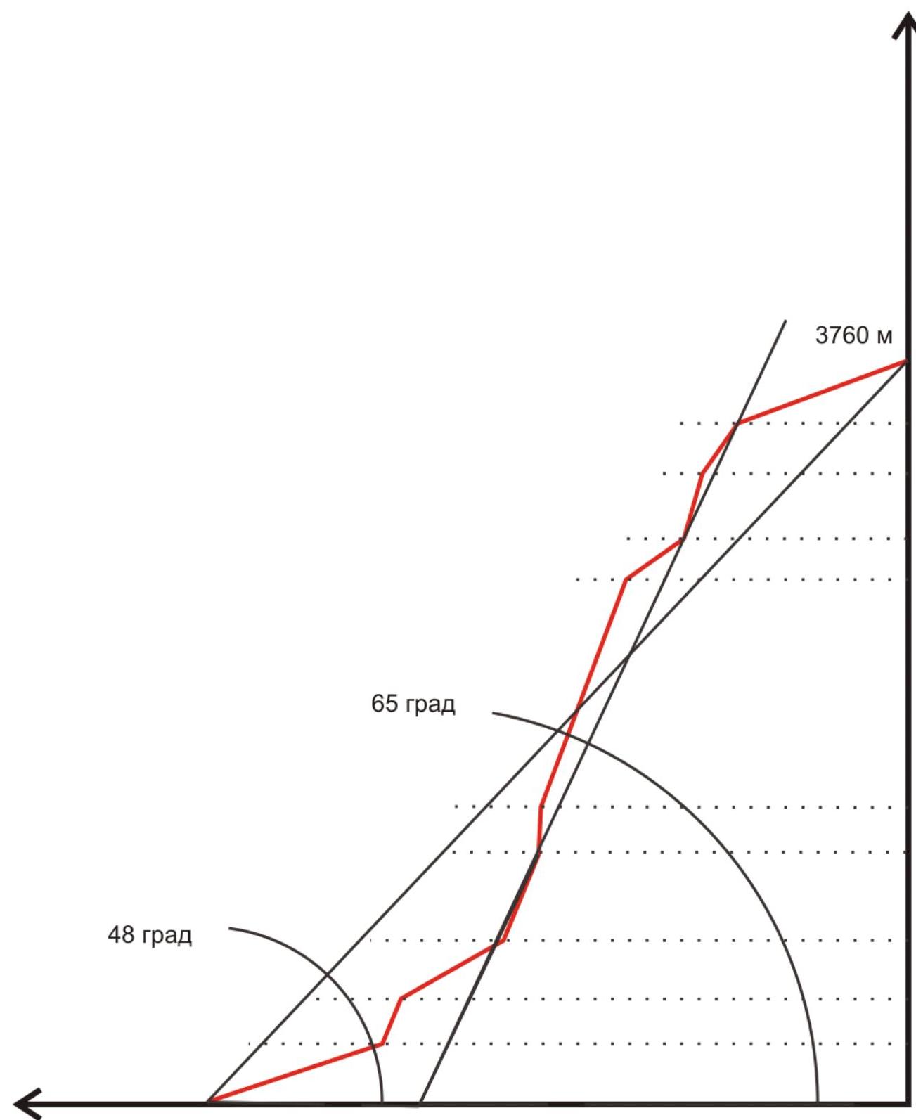
Route length: 1105 m.
Length of sections: category V - 90 m, category VI - 45 m. Average steepness: main part of the route - 65°, entire route - 48°.
-
"Pitons" left on the route: The count of used pitons was not kept. The route was completed entirely with free climbing (without the use of artificial technical aids). Bolt hammers were not used. Not a single "own" point was left on the route.
-
Team's climbing hours: 6 hours, 0.4 days
-
Leader: Foygel Maxim Rafailovich (Candidate for Master of Sports) Participants:
- Afanasyev Oleg Gennadievich (Candidate for Master of Sports)
- Panov Yuri Gennadievich (Candidate for Master of Sports)
-
Coach: Afanasyev Oleg Gennadievich
-
Departure from "Uzunkol" tourist center to the route: 12:00, August 15, 2008 Arrival at the summit: 14:30, August 16, 2008 Return to "Uzunkol" tourist center: 20:00, August 16, 2008
General photo of the summit
Dolomit Centralny (3760 m)
Route via the left edge of the western wall 5A "Mechta" (team's path)
Route via the western wall 4B "Kniga" (Yu. Melnik, 1965)
Date taken: August 15, 2008
Location: spur of the peak 40th TASSR
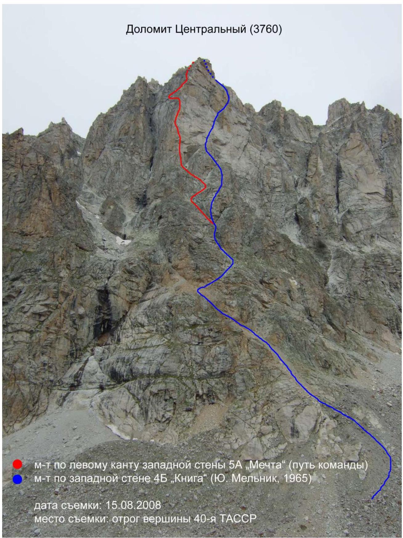
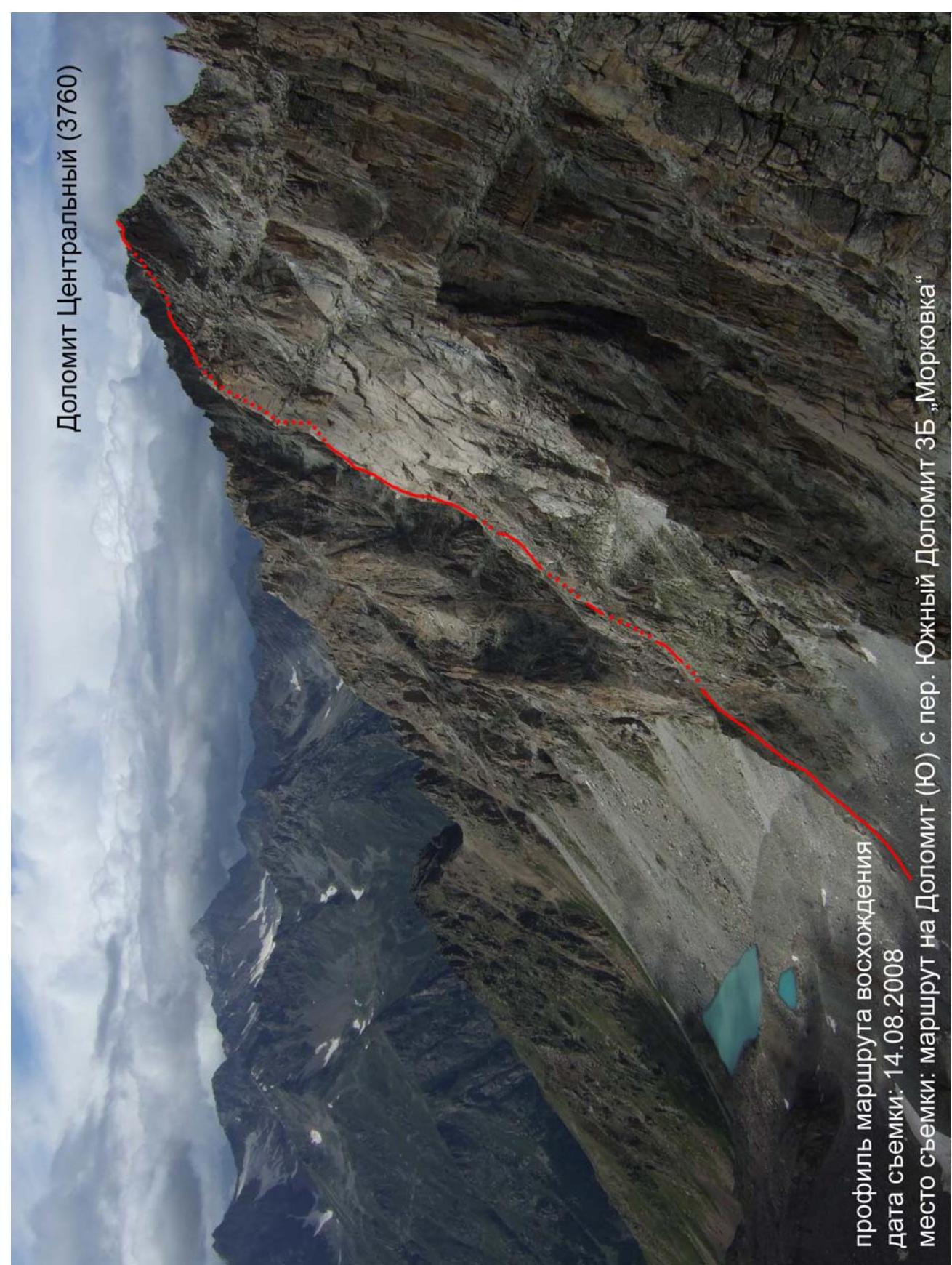
Photo profile of the route
Dolomit Centralny (3760 m)
Profile of the ascent route
Date taken: August 14, 2008
Location: route to Dolomit (S) from col Dolomit South 3B "Morkovka"
Drawn profile of the route
48°
65°
3760 m
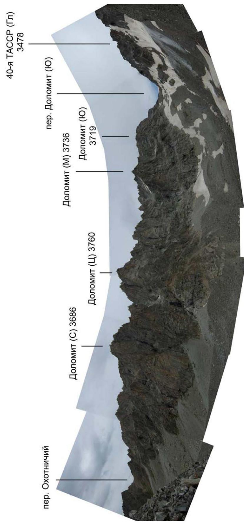
Photopanorama of the massif
40th TASSR (Main) 3478 m
Col Okhotnichy
Col Dolomit (S)
Dolomit (M) 3736 m
Dolomit (C) 3686 m
Dolomit (Central) 3760 m
Dolomit (S) 3719 m
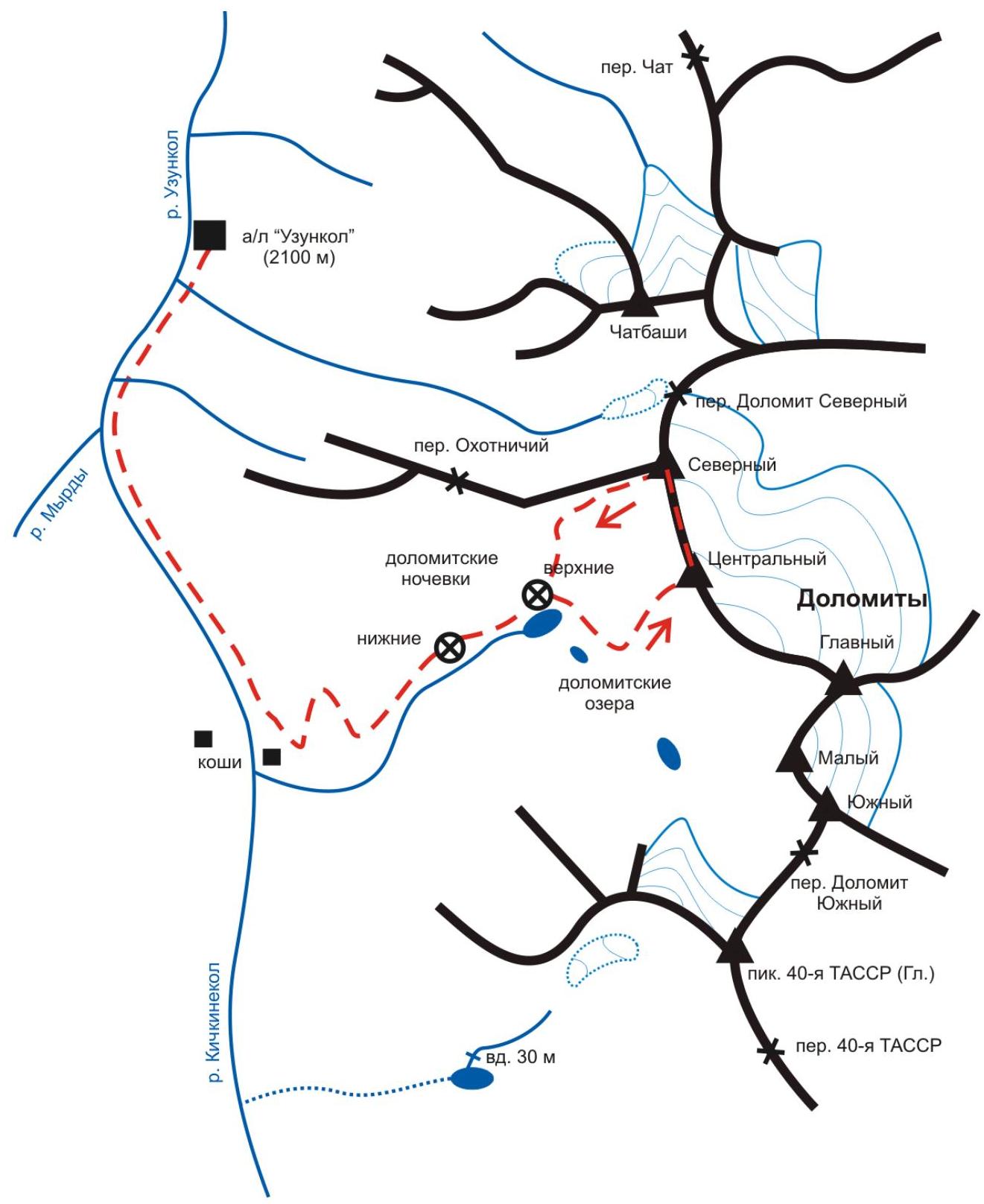
Area map
8wOgC/img-6.jpeg","id":64745316})
Approach description
From "Uzunkol" tourist center, follow the trail starting right behind the camp for 15 minutes to the logging road. Along the road, bypassing the border post, ascend to the Kichkenekol gorge. Here, the road ends, and further on, follow a good trail to Kosha. From the camp, it's 1 hour. From Kosha, a trail leads left upwards to the Dolomity camps. Follow this trail upwards to the big (second in count) terrace with large rock blocks. Here are the lower Dolomity camps, 2 hours from Kosha. From here, continue upwards along the trail to reach the Dolomity lakes (upper Dolomity camps), 1 hour from the previous stop. From the lower lake, follow the trail through the old moraine towards the Dolomit South pass. Level with the middle lake, leave the trail and ascend to the base of the wide talus couloir under the western wall of Dolomit (Central). At the base of the couloir is the start of the route, 0.5 hours from the lower lake.
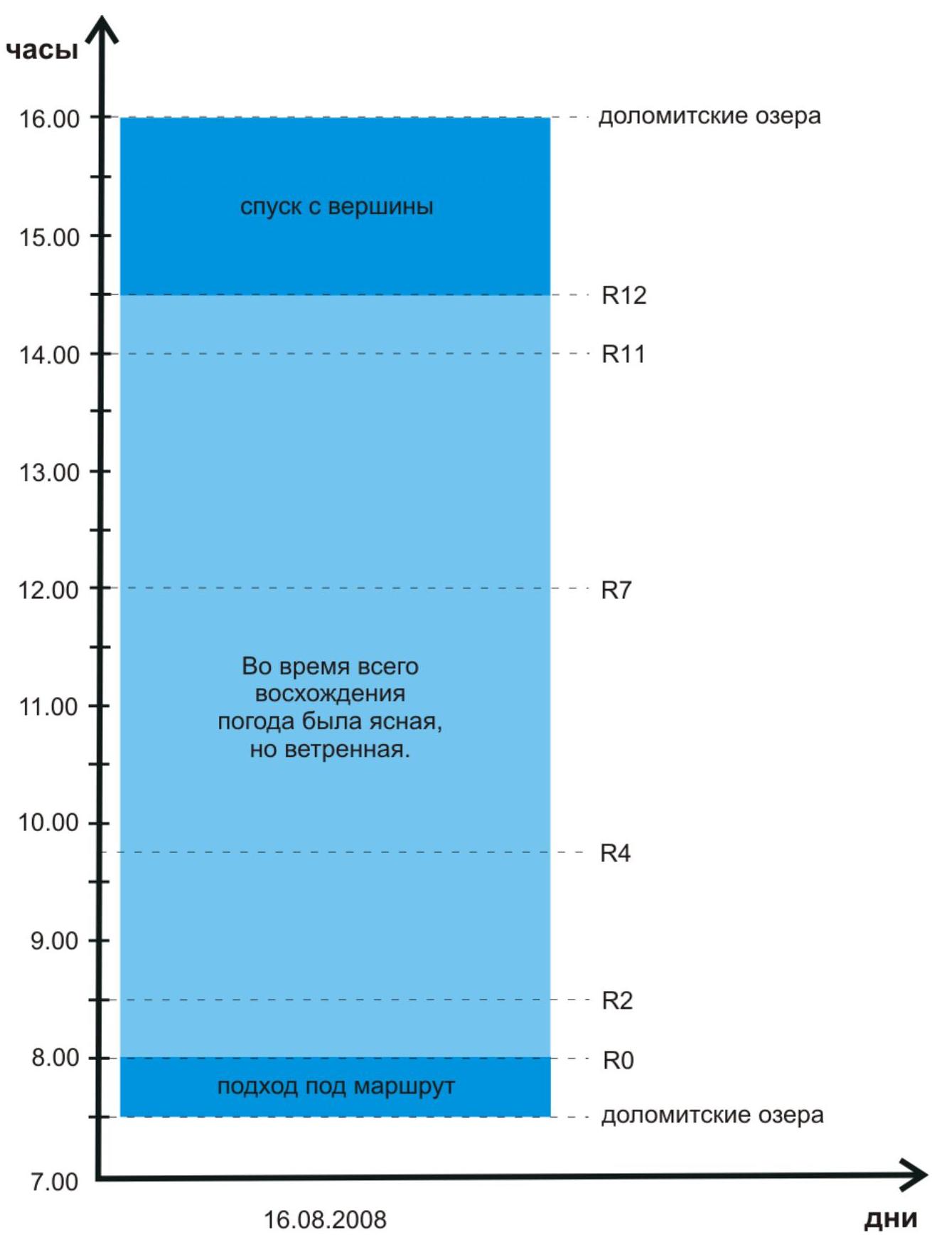
Ascent schedule
hours 16:00 Descent from the summit 15:00 14:00 13:00 12:00 11:00 Throughout the ascent, the weather was clear, but windy. 10:00 9:00 8:00 7:00 August 16, 2008 Approach to the route Dolomity lakes R12 R11 R7 R4 R2 R0 Dolomity lakes Days
UIAA scheme
Dolomit (C) 3760 m R12 Summit Descent via Dolomit (S) summit Internal angle "Kniga" R11 2-3 300 m R10 4 40 m 50° R9 F5c 30 m 80° R8 1-2 50 m R7 3 70 m 50° R6 F4-5a 40 m 70° R5 F6a 40 m 70-90° R4 F5a 35 m 70° R3 1-2 130 m R2 F5a 40 m 70° R1 3 30 m 45° R0 N/K 300 m
Technical photograph of the route
Dolomit Centralny (3760 m)
Route via the left edge of the western wall 5A "Mechta" (team's path)
Date taken: August 15, 2008
Location: spur of the peak 40th TASSR
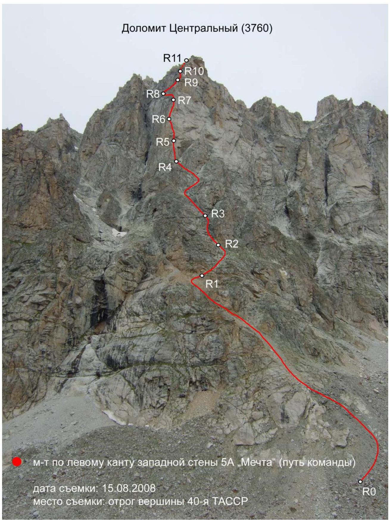
Route description
R0–R1 N/K 300 m Along the wide talus couloir to the place where one can ascend via simple rocks to the right and upwards to the base of the wide internal angle "Kniga" (landmark for the lower part of the route). In June-July, snow may lie in the couloir.
R1–R2 3 30 m 45° Ascend via simple rocks to a wide talus terrace under "Kniga".
R2–R3 F5a 40 m 70° Up the left "page of Kniga". After about 20 m, move to the right and exit to a ledge under a large plug wedged in the upper part of the internal angle "Kniga".
R3–R4 1–2 120 m From the plug, ascend left upwards to a wide talus shelf and along it for about 80 m to a logical ascent to the right to the base of a large inclined internal angle, under the cliffs of the western wall.
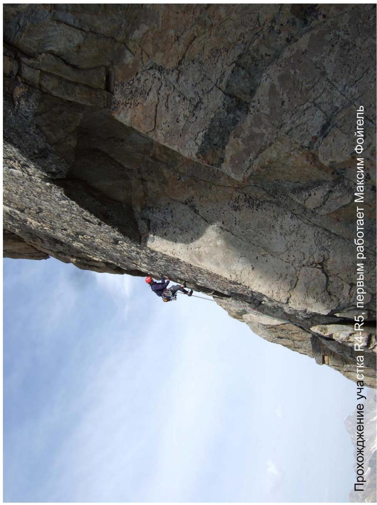
R4–R5 F5a 35 m 70° From the base of the large internal angle upwards along the crack under the overhanging rock ledge.
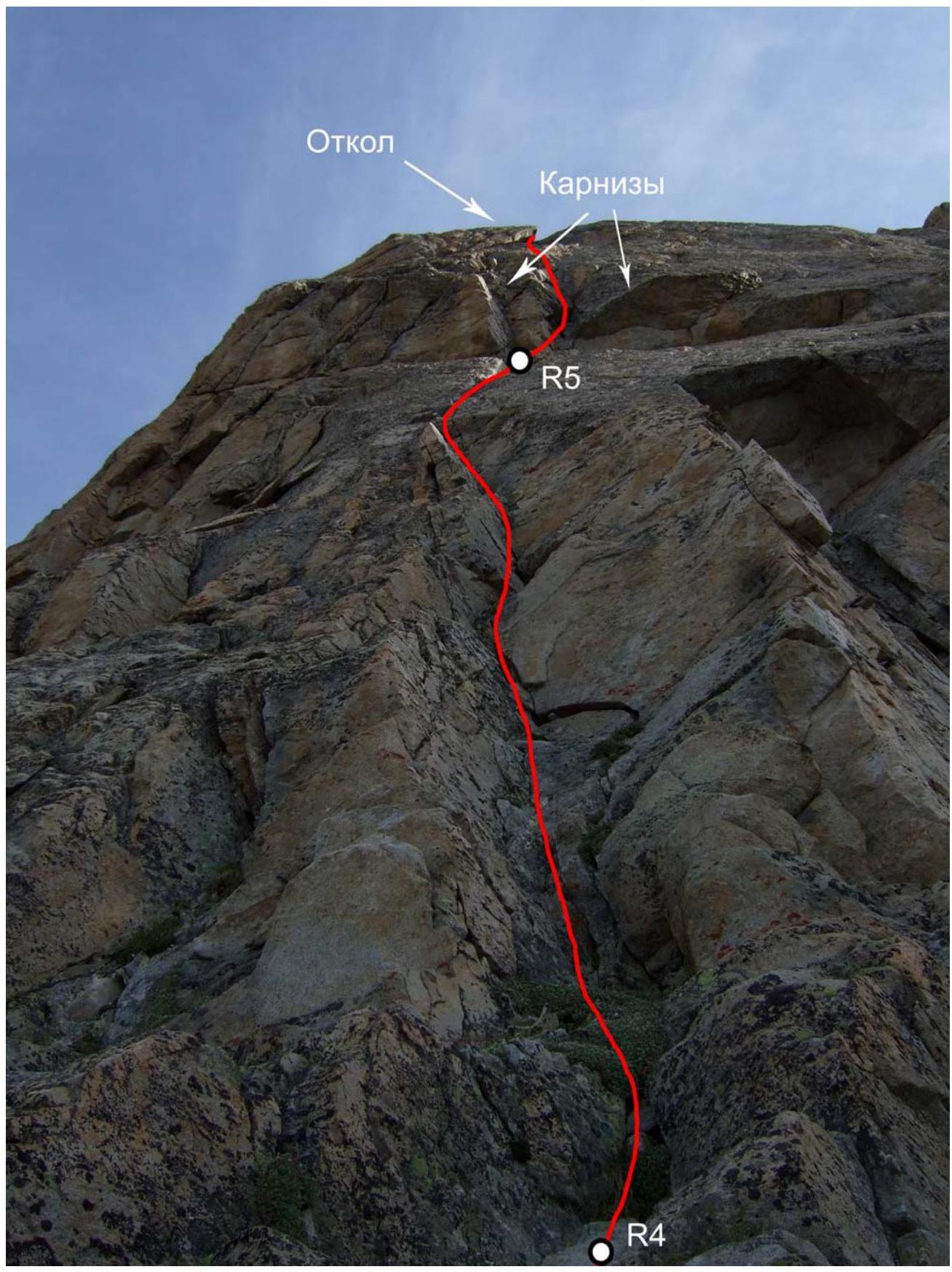
R5–R6 F6a 40 m 70-90° The first key rope of the route. From the belay station upwards through the internal angle via cornices (8 m F6a 90°). Then along a system of cracks to a flake (15 m F5b 80°). Through the flake, exit to a more gentle slope (5 m F6a 80°) and ascend via simpler terrain to the edge of the western wall.
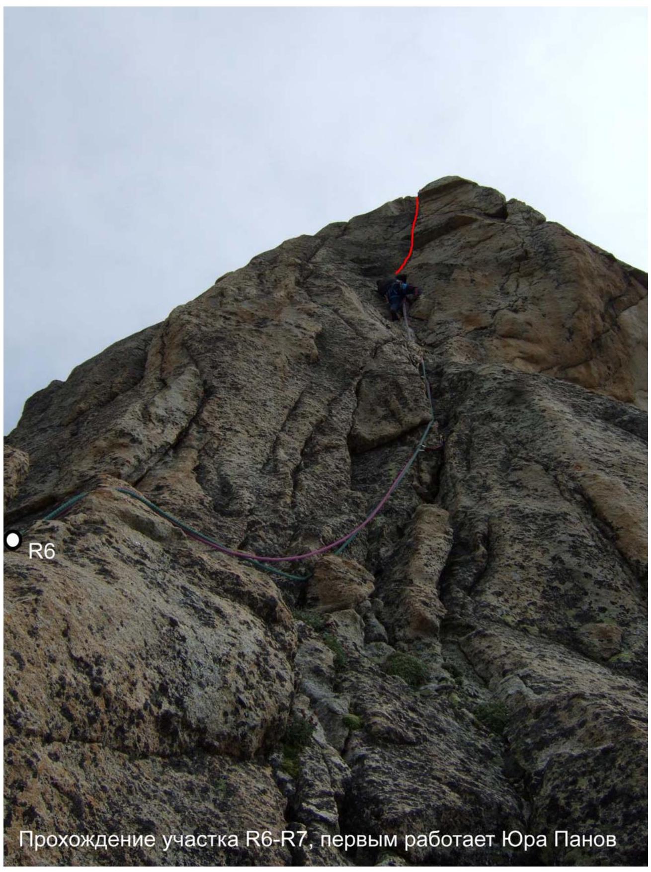
R6–R7 F4–5a 40 m 70° From the belay station upwards along the crack and internal angle along the edge of the western wall, past a bend onto a ledge.
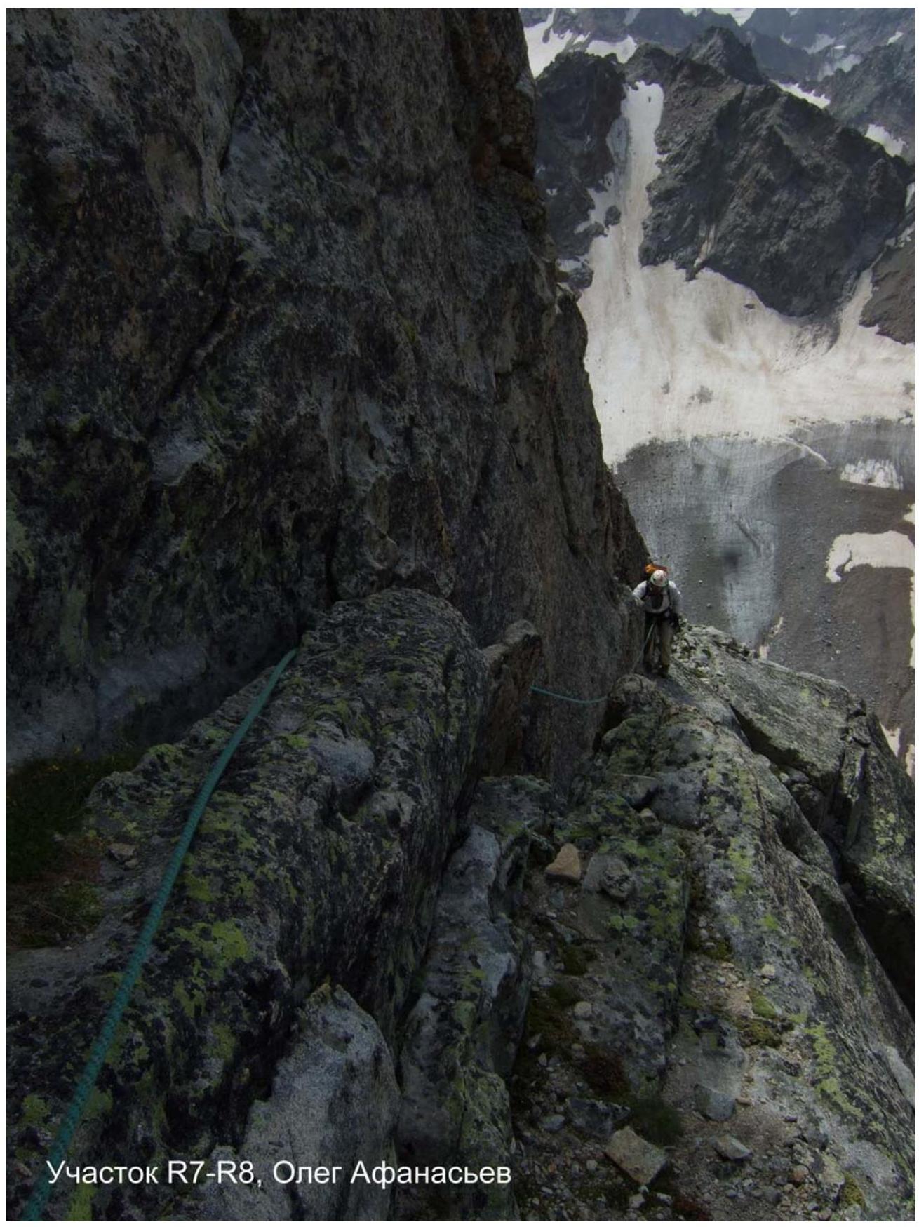
R7–R8 3 70 m 50° From the ledge upwards along the edge of the western wall under a steep wall and then traverse along a shelf to the left. To the next wide ledge with large blocks.
R8–R9 1–2 50 m Along the wide ledge with large blocks to the right to the edge of the western wall.
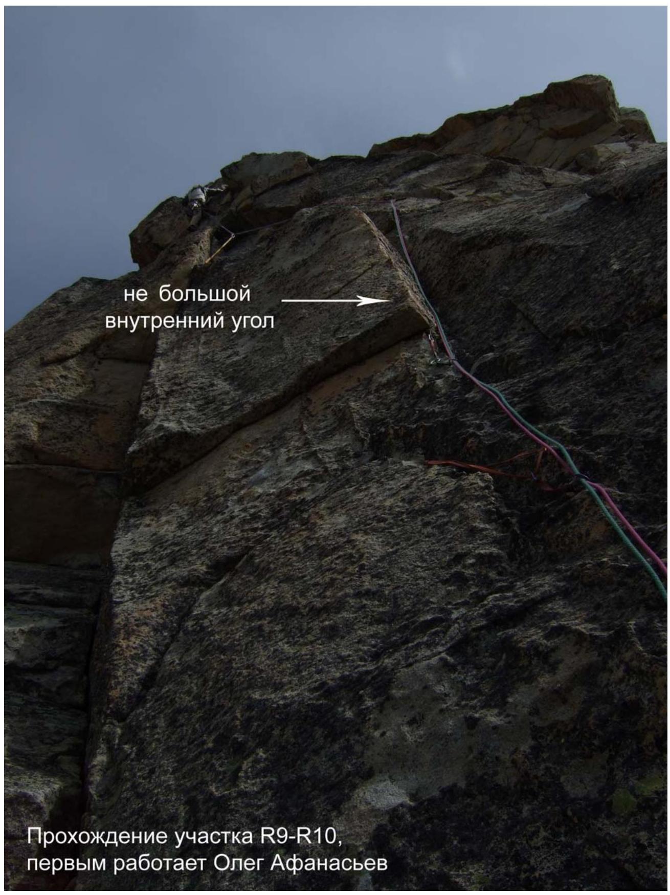
R9–R10 F5c 30 m 80° The second key rope of the route. Along the left side of the edge of the western wall through a small internal angle, exit to a monolithic slab.
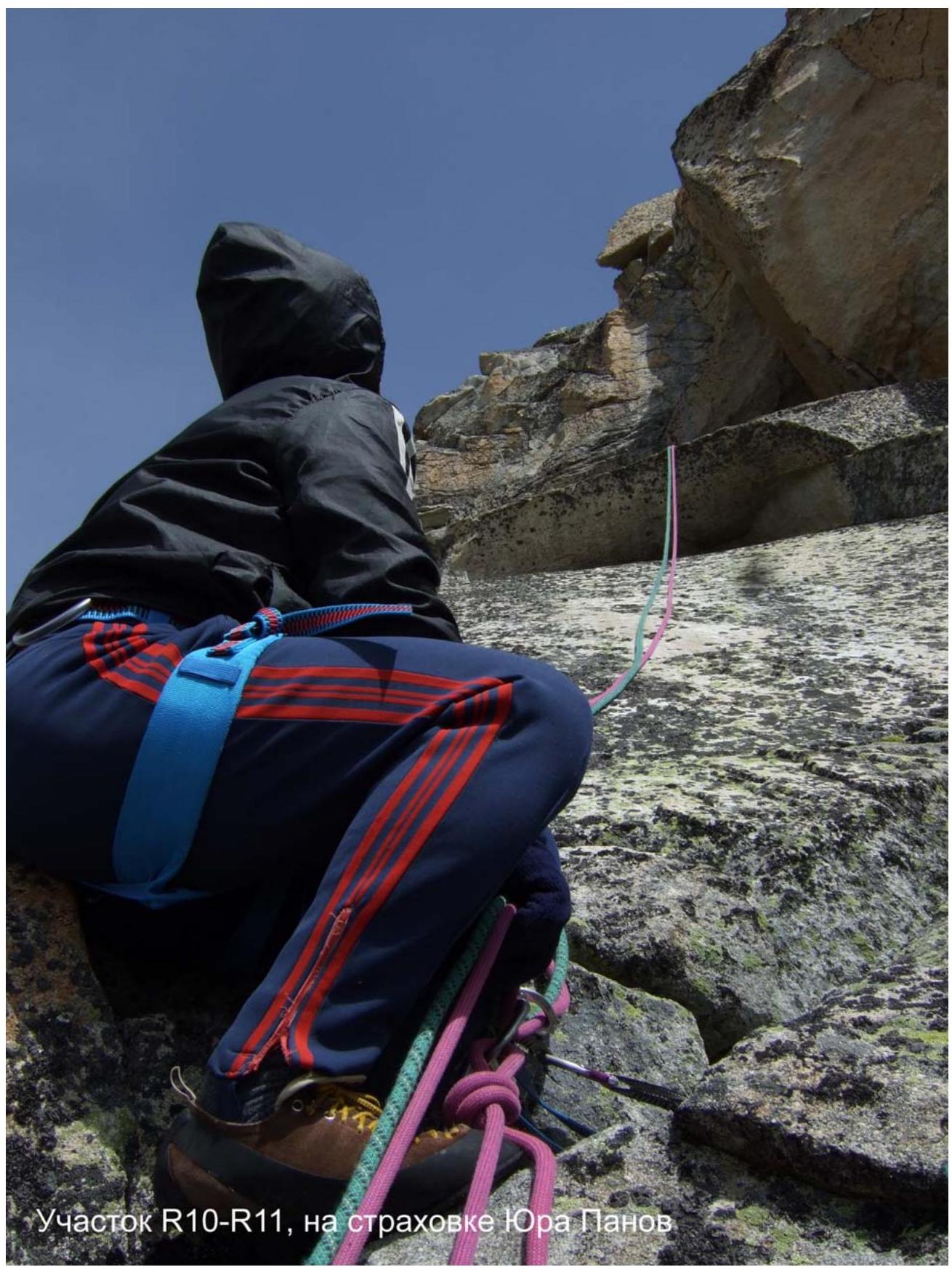
R10–R11 4 40 m 50° Up the slab and further along the ridge rocks for about 20 m. Then ascend to the ridge.
R11–R12 2–3 300 m Further movement is first to the left and then to the right along the ridge rocks to the summit.
Descent description
From the summit Dolomit (C), descend via the ridge to the saddle between Dolomit (C) and Dolomit (S). From the saddle, ascend via simple rocks of the ridge to the summit Dolomit (S), 0.5 hours. Then descend via scree along the western spur (ridge) of Dolomit (S) to the lower lake, 1.5 hours.
Photo illustrations
Flake
Cornices
R5
R4
 Passage of section R4–R5, Maxim Foygel leads
 R6
Passage of section R6–R7, Yuri Panov leads
R6
Passage of section R6–R7, Yuri Panov leads
 Section R7–R8, Oleg Afanasyev
 Small internal angle
Passage of section R9–R10, Oleg Afanasyev leads
Small internal angle
Passage of section R9–R10, Oleg Afanasyev leads
 Section R10–R11, Yuri Panov on belay