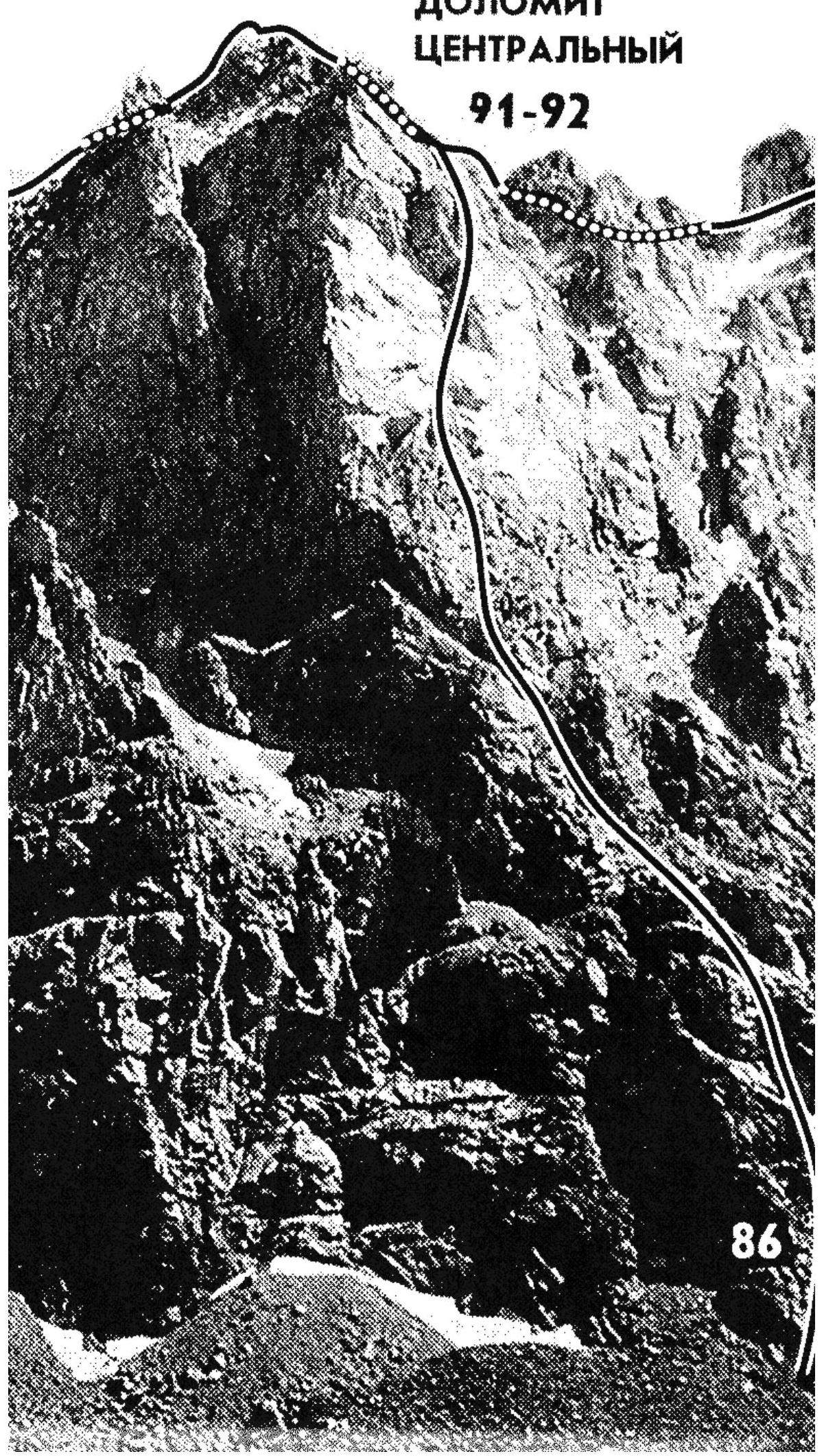
M86. Dolomit Tsentralny via West Face
(rock route, category 4B, first ascent by Yu. Melnik, 1965)
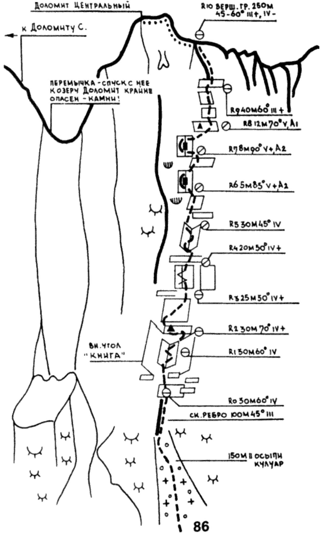
From the lake, head up and to the right along the scree towards the couloir between the North (left) and Central (right) Dolomites. The couloir ends at the bottom with a block of steep cliffs resembling "ram's foreheads". Ascend to a small rocky ridge via its lower right part, 150 m from the couloir. The ridge divides in half two short, gentle couloirs resembling internal corners to the right of the main couloir. From here, the starting point of the route is visible - a huge internal corner - the "Book". The ascent to the ledge R0 below the "Book" follows the terrain without visible landmarks and lacks a defined line. It takes 3.5 hours from the bivouac.
From the R0 ledge, ascend via the crack with the overhanging left "page of the book". Then, move up and to the right along a sloping ledge, cross to the other "page of the book", and exit it via the internal corner onto a ledge to the control cairn R2 (strenuous climbing).
From the cairn, traverse 4 m to the left along the slab, then ascend to a small ledge. From here, via the R3 crack between two slabs, exit under the overhang of the left slab into an internal corner (strenuous climbing; when there's verglas on the slabs, the middle 10 m of the slab are traversed using ladders). Ascend 8 m up the corner and then move right onto a grey slab - an internal corner leading to a narrow ledge R5. It takes 3.5 hours from the "Book".
From the slab's edge, move left and ascend up and to the right, bypassing monolithic overhangs along a 10-meter narrow ledge. At its end, ascend straight up along smooth rocks (beware of loose rocks! blind cracks). Reach the next ledge R7. It's also possible to ascend directly from R6 via a hanging crack, but if it's icy, it's better to go to the right.
The next section of the route is complex and psychologically tense. The direction of movement is dictated by the terrain itself, and its condition (verglas or dry rocks) determines the choice between using ladders and free climbing. The section ends at a platform with a control cairn R8. It takes 4-5 hours from R5. From here, large-blocky rocks of the ridge lead to the summit in 40 minutes.
The descent from the summit follows the ridge to the left onto a saddle, and then along the talus slopes, ascend to the North Dolomit peak. From it, descend along the ridge to a large talus saddle before the sub-summit, from which the strongly serrated western ridge descends to the Okhotnichy pass. Along the fine scree under the cliffs of this ridge, crossing small couloirs closer to it (do not go left - steep rock drops and smooth "ram's foreheads"!), reach the Okhotnichy pass. From it, descend along the trail to the Dolomity lakes.
It takes 2.5 hours from the Central Dolomit.
Recommendations:
- number of participants - 2-4 people;
- it's not recommended to start the route after bad weather;
- it's possible to return from the route up to the R4 section;
- if bad weather catches you above R5-R6, only move upwards.
Dolomit Tsentralny