To the Classification Commission of the Russian Alpine Federation.
Ascent Passport
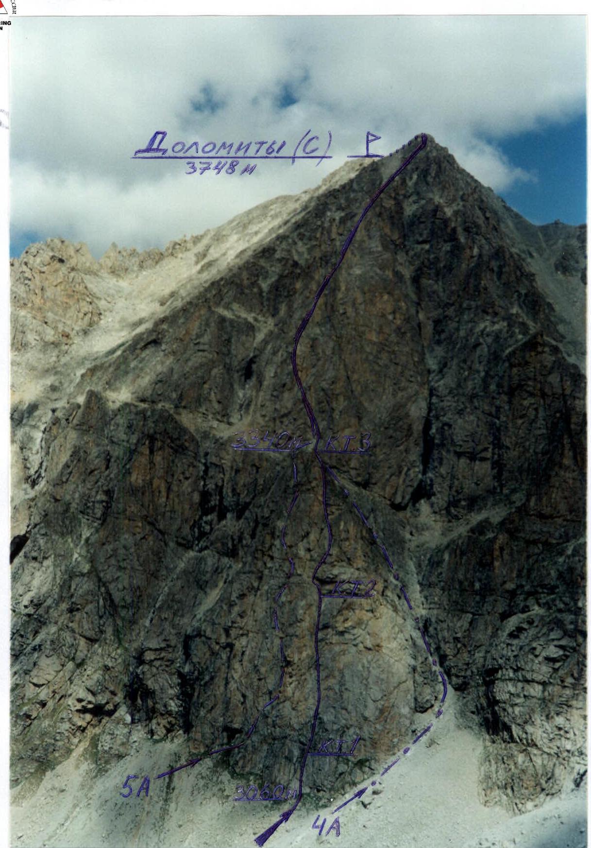
- Western Caucasus. Uzunkol. 2.3.
- Dolomity (C) 3748 m, via the center of the bastion of the 3rd wall, through the "reddish corner".
- Claimed - 5B category of difficulty, first ascent.
- Route character - rock climbing.
- Total height difference of the route - 690 m, lower bastion - 280 m.
Section lengths:
- 5B category of difficulty - 310 m
- 6B category of difficulty - 80 m
Average steepness of the route - 70°. Lower bastion - 86°.
- Pitons left on the route: total - 25 pcs., including bolts - 10 pcs. Used (pitons / for ITO): rock placements, bolts, removable bolts 22 / 3, 68 / 6, 10 / 0, 12 / 2. Total ITO points used: 11.
- Climbing hours - 29 hours, including preliminary processing - 14 hours.
- Team of two: Milenin O.N. - Candidate Master of Sports, Turchaninov I.V. - Candidate Master of Sports.
- Coach: Kavunenko Rimma Vladimirovna - Master of Sports.
- Observers: Zhilin D.A. - Candidate Master of Sports, Abramova L.V. - Candidate Master of Sports, Shulepov G.G. - 1st sports category.
- Approach to the route: August 18, 2000.
Summit: August 20, 2000. Return to base camp: August 21, 2000.
General photo of Dolomity (C) 3748 m summit taken on August 18, 2000, at 12:00 from a viewpoint, distance 1.5 km (camera "Samsung" - Abramova L.V.)
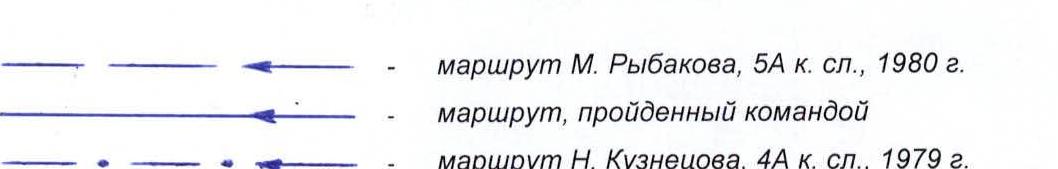
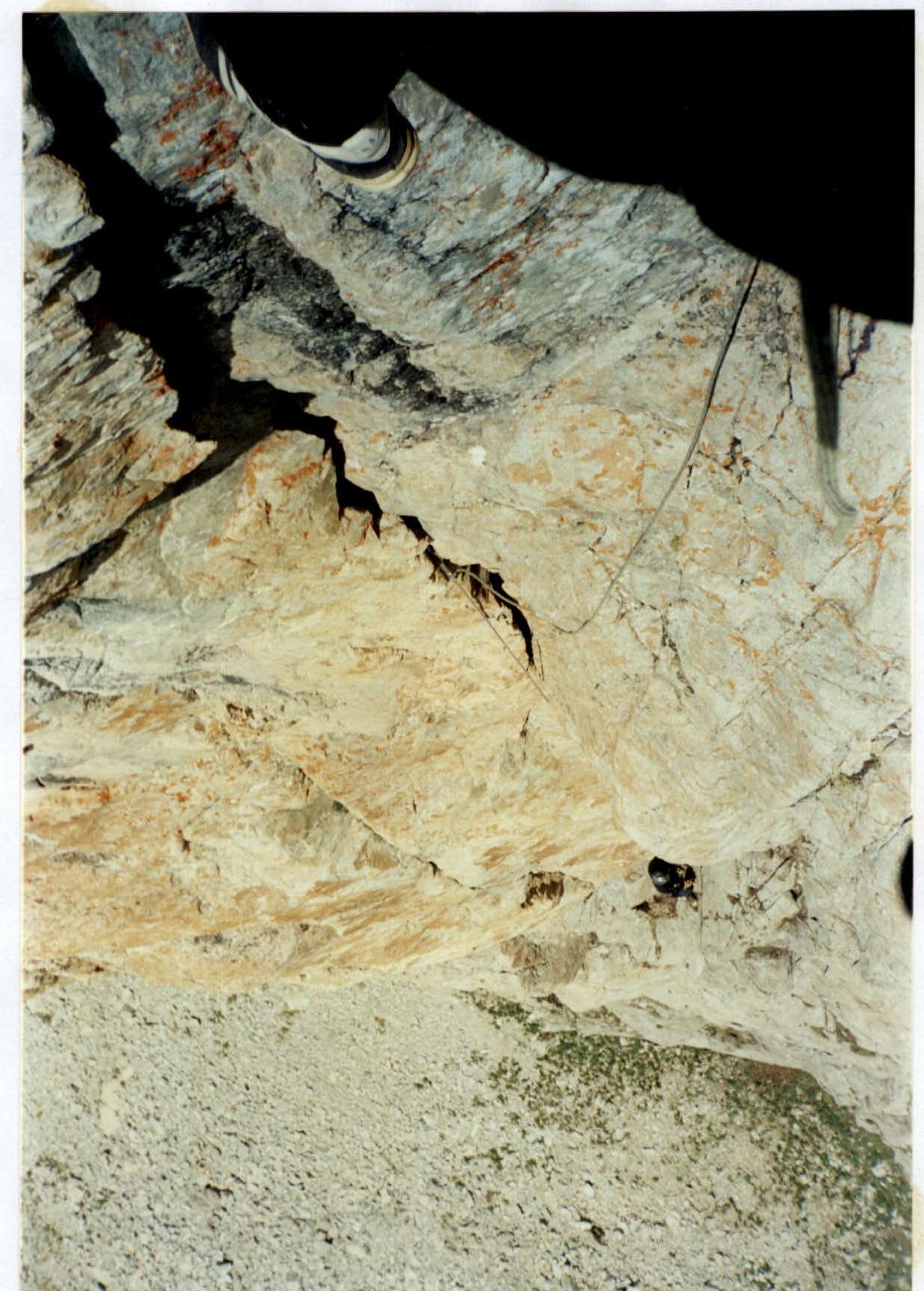
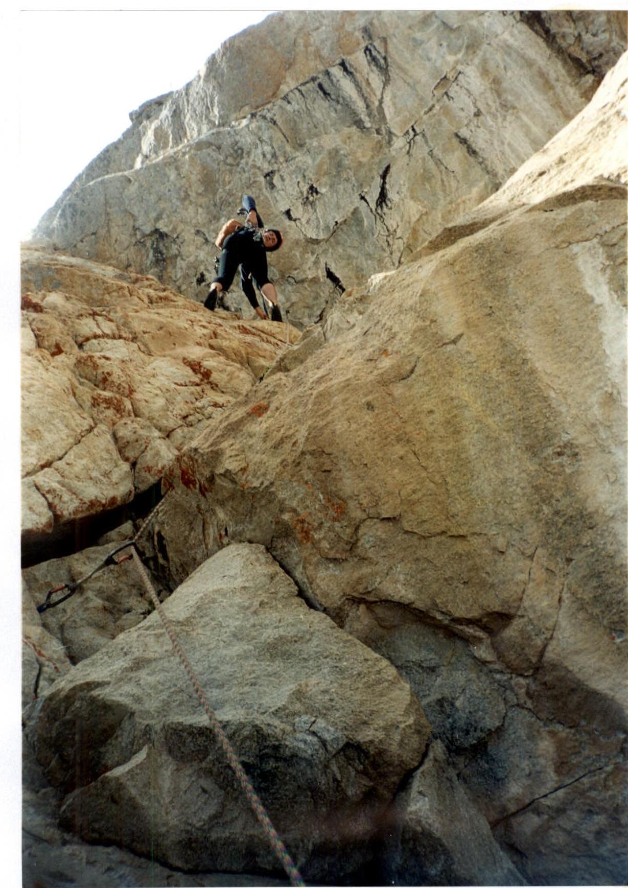
Character of monolithic rocks at the key section 8.
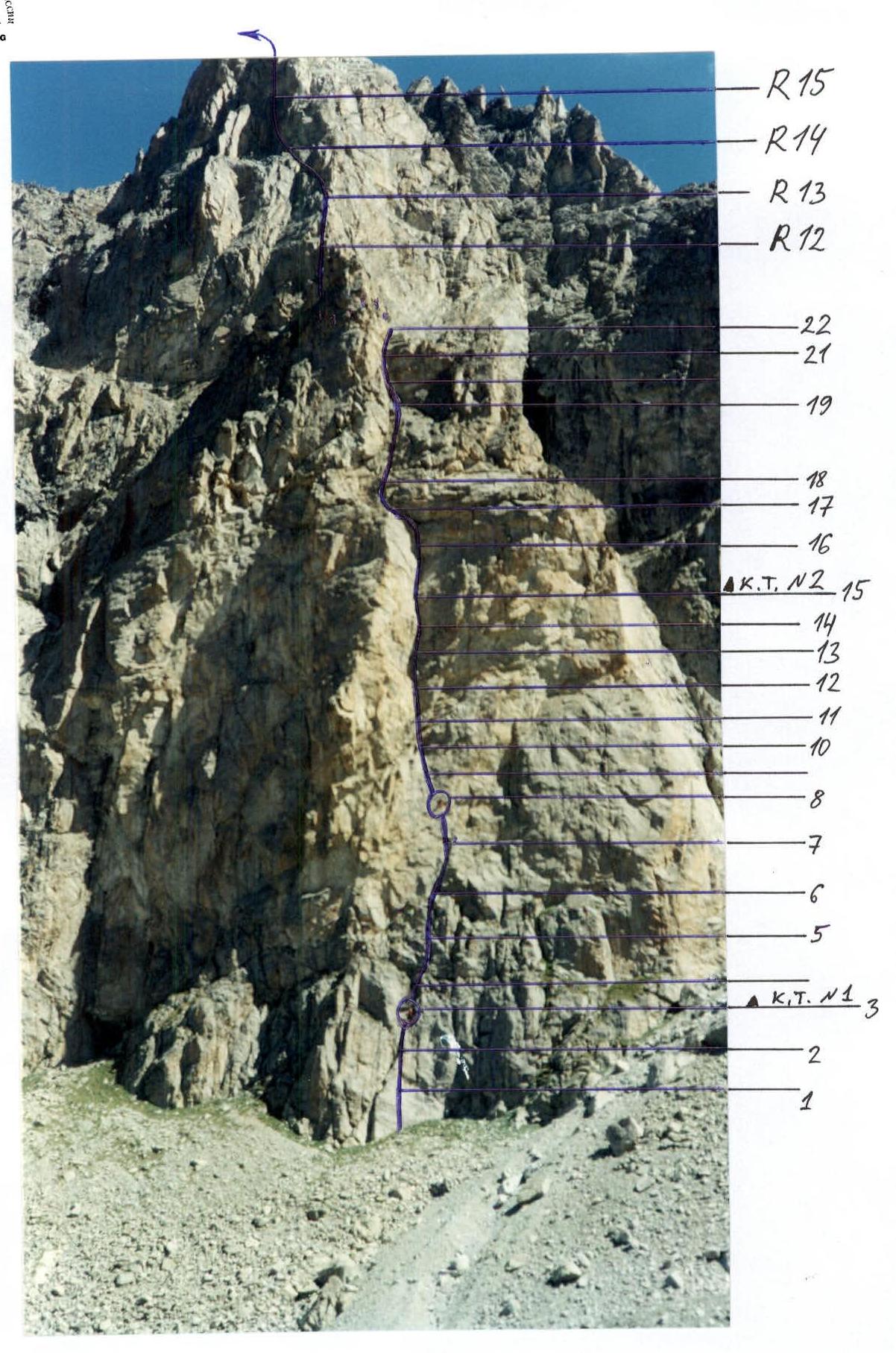
Technical photo of the route. (climbers are circled)
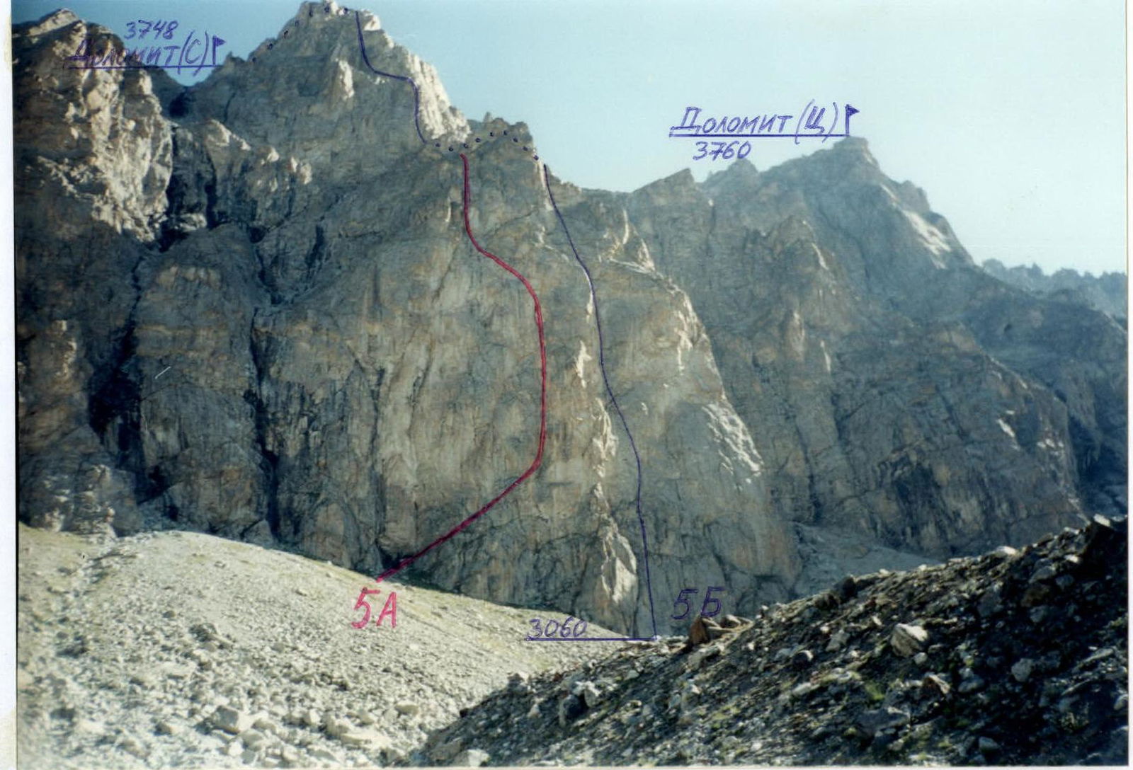
Panorama of the area. (taken from the left moraine of the lower dolomite lake on August 18, 2000, at 11:00, distance to the wall about 800 m)
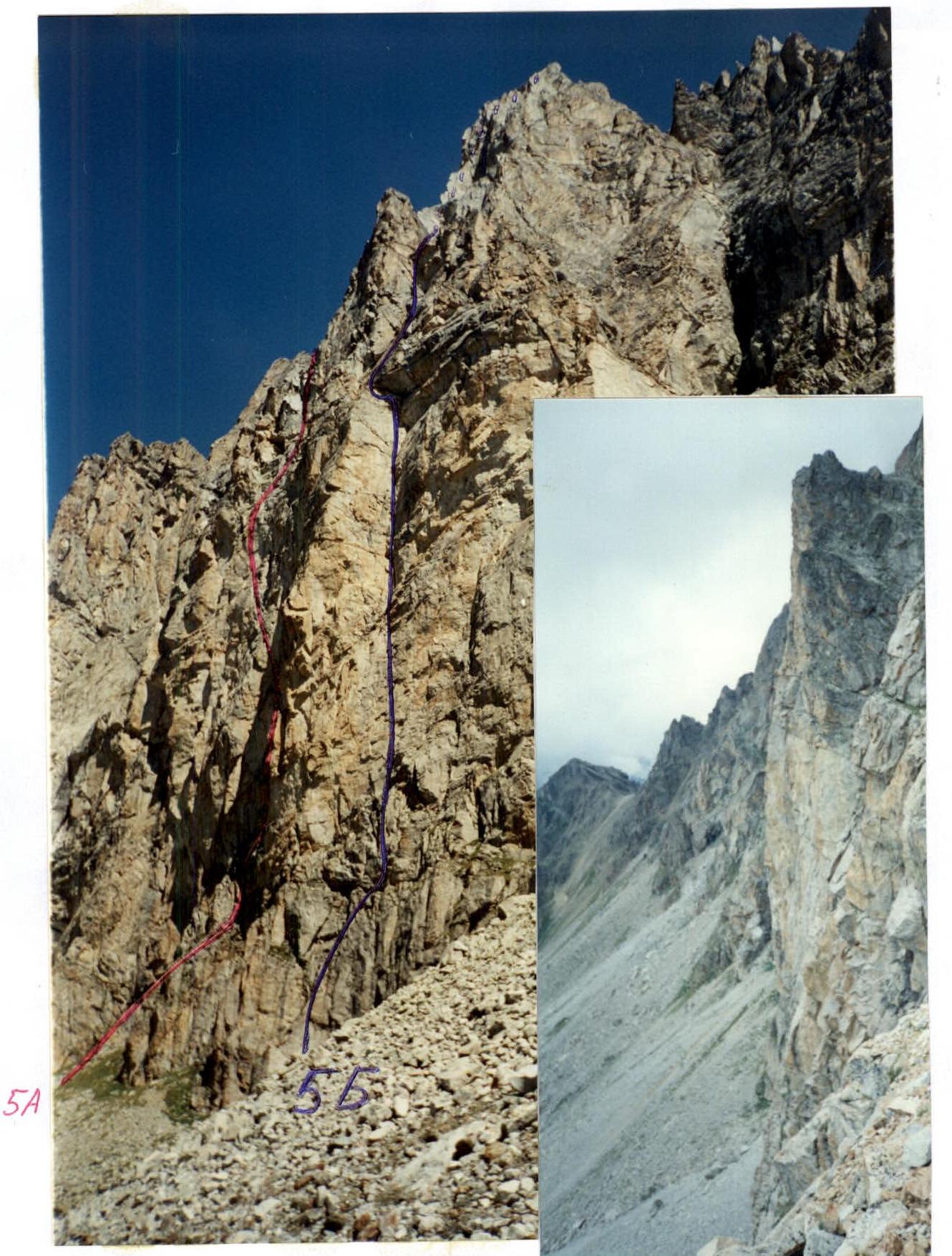
Photo of the bastion profile and its upper part on the right. (taken from the start of the 4A route on August 20, 2000, by Shulepov G.G.)
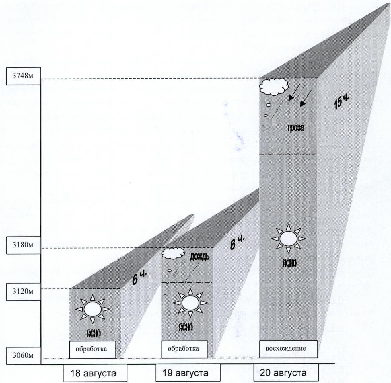
Ascent graph
Route Description
R0–R1 (sections 1–3): The start of the route is from a sign fixed on two bolts, on a smooth plate to an overhanging internal corner - a groove with rounded edges. Up the groove by climbing (6B by French classification) or on ITO (A1–A2) to two grooves that lead to a stance under an overhang (C.P. #1).
R1–R2 (sections 4–6): The movement includes:
- Climbing up the "ram's foreheads" - blocks under an overhang;
- Traverse right to the internal corner;
- Exit to a small ledge.
R2–R3 (sections 7–9): The key location of the route. Complex climbing on monolithic rocks is replaced by difficult ITO A3–A4. Used:
- small placements,
- petal pitons,
- skyhooks. Approach to the overhangs via a slab. If climbing (6C+), then the distances between reliable protection points reach 8 m. Overhangs are climbed directly (6B+).
R3–R4 (sections 10–13): First on slabs, then through overhanging slabs - cornices to a convenient ledge for one person.
R4–R5 (sections 14–15): From the stance right to the internal corner, then to a three-meter cornice, bypassed on the left. Exit to an inclined slab. C.P. #2.
R5–R6 (sections 16–18): Up the strongly overhanging internal corner. In the corner:
- a crack-groove 20–30 cm wide. Difficult climbing. Difficult to organize protection. The internal corner abuts a three-meter overhang. From under the overhang left along a groove under a large ten-meter cornice - a roof. From under it, pendulum left, then:
- up,
- right along a small internal corner and slabs to a stance on a slab.
R6–R7 (section 19): Up monolithic slabs on friction under a series of overhangs. Stance.
R7–R8 (sections 20–22): Up the internal corner - a flake left up to overhanging oblique grooves. Along them right by complex climbing to the top of the bastion.
R8–R9 (section 23): Simple exit to the top of the bastion. C.P. #3.
R9–R10: From the base of the counterfort up the slabs to under a chimney. R10–R11: Up the chimney to a small ledge. R11–R12: From the ledge left, then through an overhang to a large ledge. R12–R13: Exit to the scree belt. R13–R14: Bypass the belt on the left and peek over the sharp ridge. R14–R15: Further up the grooves of a wide couloir. R15–R16: From the couloir, exit to the ridge. Along the ridge left. R16–R17: Easy climbing along the ridge ends with scree fields. Then about 300 m walking to the summit of Dolomity (C).
Descent from the summit along steep scree slopes towards the "Ohotnichy" pass; in poor visibility, stick closer to the rock ridge - there is a trail leading to the lower dolomite lake.
Section R10–R12.
Section R16. (Milenin approaching under a large cornice)
Route Diagram in UIAA Symbols
| Section # | rock pitons | placements | bolts (* - removable) | route | section difficulty | section length, m | steepness, deg. |
|---|---|---|---|---|---|---|---|
| 23 | - | 2 | - | C.P. #3 to the top of the bastion, 3340 m | 2 | 70 | 40 |
| 22 | 2 | 3 | - | exit to the bastion | 5+ | 15 | 90 |
| 21 | 1 / 1 | 1 / 1 | 1* | 6, A2 | 10 | 95 | |
| 20 | 1 | 2 | - | 5 | 15 | 75 | |
| 19 | 1 | 2 | 2 | 5 | 40 | 75 | |
| 18 | 1 | 1 | 1* | 5 | 15 | 80 | |
| 17 | - | - | 1 | pendulum left 9 m | 5+ | 10 | 90 |
| 16 | 1 | 3 | - | 5+ | 15 | 85 | |
| 15 | 2 | 3 | 1+1* | C.P. #2 | 5+ | 15 | 80 |
| 14 | 1 | 4 / 2 | - | 6, A2 | 15 | 105 | |
| 13 | 1 | - | 1* | 6 | 5 | 95 | |
| 12 | - | 4 | 1+1* | 5+ | 15 | 85 | |
| 11 | 1 | - | 1* | 5+ | 8 | 90 | |
| 10 | - | - | 1+1* / 1* | 6, A1 | 10 | 85 | |
| 9 | 1 | 2 | - | 6 | 5 | 95 | |
| 8 | 2 / 1 | 1 / 1 | 1* / 1* | 6, A3 | 10 | 85 | |
| 7 | 1 | 1 | 1* | 6 | 15 | 90 | |
| 6 | - | - | 1+2* | 5+ | 12 | 80 | |
| 5 | - | 1 | 1 | 5+ | 10 | 90 | |
| 4 | 1 | 1 | - | 5 | 10 | 90 | |
| 3 | - | 2 | 1+1* | C.P. #1 | 5+ | 10 | 80 |
| 2 | 1 / 1 | 2 / 2 | 1 | 6 | 10 | 95 | |
| 1 | 1 | - | - | 5+ | 10 | 80 | |
Route Diagram in UIAA Symbols (continued)
| rock pitons | placements | route | section difficulty | section length, m | steepness, deg. |
|---|---|---|---|---|---|
| - | 3 | exit to Dolomity (C) summit, 3748 m, August 20, 2000 at 19:04 | 3 | 300 | - |
| - | 3 | R17 | 3 | 200 | - |
| - | 6 | R16 | 4 | 50 | 70 |
| 1 | 8 | R15 | 5 | 50 | 75 |
| - | 4 | R14 | 3+ | 60 | 60 |
| - | 2 | R13 | 3+ | 50 | 55 |
| 1 | 2 | R12 | 4–5 | 45 | 75 |
| 1 | 7 | R11 | 5+ | 30 | 85 |
| - | 5 | R10 | 4+ | 45 | 65 |
| R9 |