Ascent Form
- Ascent category: rock climbing
- Ascent area: Nakhara spur of the Main Caucasian Range
- Ascent route with indication of peaks, their heights, route complexity (etc., approximately): South wall of Dvuzubka peak, height 3400 m, 5B category of difficulty
- Ascent characteristics: Route length 820 m, height difference 550–600 m, average steepness 75°, complex sections length 670 m
- Pitons driven: rock 114, chocks — 47. Ice and bolt pitons.
- Number of climbing hours 34 h
- Number of climbing days 3
- Number of overnight stays and their characteristics: two sitting bivouacs on comfortable ledges
- Team name: Central Sports Council of the "Burevestnik" Sports Club team.
- Surname, name, patronymic of the leader, participants, and their qualification: Nepomnyashchy Anatoly Vladimirovich MS — leader, Shalagin Alexander Mikhailovich MS, Kolyshkin Valery Alekseevich, Tsymbal Alexander Dmitrievich MS.
- Team coach: Nepomnyashchy Anatoly Vladimirovich.
- Date of departure and return: July 19, 1978 – July 21, 1978
1. Brief Geographical Description of the Ascent Area
1.1. Ascent Object
Dvuzubka peak is located in a small ridge — a branch of the Main Caucasian Range to the north-northeast in the Nakhara pass area. This rocky ridge separates the hydrographic system of the Gondoray river from the Nakhara river system and is crucial for the water balance of these rivers, as small glaciers at the base of the ridge on both sides feed these rivers.
One of such glaciers lies in a cirque formed by the rock massifs of B. Nakhara, Shidag Minge, Agu Mingge, and Dvuzubka, and feeds a stream flowing into the Nakhara river (see the area map).
If you ascend the Nakhara river valley from the confluence of the Gondoray and Nakhara rivers, this stream will be the third in count from all the streams flowing from the western slopes of the Nakhara ridge (spur). At its upper reaches on the moraine scree of the glacier is a good spot for a base camp for climbers.
1.2. Climbing Conditions in the Area
1.2.1. Relief Features
The south wall of Dvuzubka is composed of granites and is mostly monolithic, but individual splits and chips still pose a risk of rockfall when subjected to external impact.
The forms of rock relief are very diverse and require the application of all free climbing techniques.
Despite the significant steepness of the route, it can be climbed entirely using free climbing (even overhanging sections), provided one has excellent rock climbing skills.
1.2.2. Climatic Conditions
The weather in the application area corresponds to the conditions in the Uzunkol tourist center area. A distinctive feature of the climatic conditions for climbing Dvuzubka peak via the South wall is: heat in good weather and a complete lack of water on the route. By the second half of July, there are no signs of moisture on the wall. It can be assumed that in May and June, small accumulations of snow can still be found in deep cracks and chimneys in the upper part of the route.
1.2.3. Access Routes
The nearest settlement to the object is Uchkulan. From Uchkulan, there is a dirt road leading to a cattle shed located on the left orographic bank of the Nakhara river, about 7–8 km from the confluence of the Gondoray and Nakhara rivers.
From the cattle shed, a car can still reach a bridge over the Nakhara, which is a large felled tree. From this bridge, a trail leads upstream along the Nakhara river to the stream flowing from the aforementioned cirque. Further upstream along the stream to the base camp. From the cattle shed to the base camp — 3 hours. From the base camp to the start of the route — 1 hour.
2. Ascent Organization
2.1. Team Preparation
During the off-season preparation, the team conducted four training sessions per week from October to February and five to six training sessions per week from March to June for general physical and special preparation.
General physical training included: cross-country running, swimming twice a week, and sports games. Special training was conducted during spring weekend trips to the area of rock outcrops near Stepano-Krynka village. During each such trip on a Saturday and Sunday, each participant would "run" through one and a half to two kilometers of rock.
In May, team members worked as coaches at the Rostselmash "Digoriya" alpine camp.
To prepare the team for the championship, a gathering was held at the Dombay alpine camp, located in an area similar in climbing conditions to the Gvandra area.
The task of the gathering was not only to prepare team members for the championship but also to work on youth education and improve the qualifications of second-tier team members, six of whom completed the Candidate for Master of Sports norm in mountaineering during the gathering.
Team members, working as coaches at the gathering, completed two ascents each of the third and fourth category of difficulty and, in preparation for the championship, a 5B category ascent to the peak Western Dombay Ulgen via the South wall of the CDS peak. The latter ascent was completed a day ahead of the usual schedule, i.e., one day to the summit and half a day for descent, demonstrating the team's readiness for the championship.
2.2. Equipment
As in previous years, great attention was paid to preparing equipment and gear for the team.
All participants have three years of experience using chock stones, which significantly speed up the group's progress along the route and allow for a new approach to solving tactical tasks. New models of this equipment were tested, withstanding loads up to 1000 kg, enabling their use for main protection.
Specially for the championship, new down equipment was manufactured, including:
- a jacket
- a "leg" that can easily be turned into down pants or a blanket
From two such "legs," one can quickly make a common "leg" for four people, convenient for sitting bivouacs on narrow ledges.
For transporting goods along the wall, as well as for personal belongings and a small public load, the following were manufactured:
- a special transportation backpack for carrying goods along the wall
- lightweight nylon wall backpacks for personal belongings and a small public load, which did not hinder progress.
For ascending on a rope, "Jumar" type ascenders were developed and manufactured, allowing for several times faster and easier ascent on a rope.
The reliability of protection was ensured by the use of a special automatic braking device like the Sticht plate and protection loops for rope alignment.
For organizing a rope team, a system was made from a harness and a chest strap, which plays an auxiliary role, counteracting the climber's overturning in case of a fall. The harness and strap are connected by a nylon strap, the ends of which are used for self-protection. This eliminates the use of unreliable cord.
The manufactured set of rock pitons includes a wide range of sizes, differing in:
- thickness
- design
- purpose
For extracting pitons, an extractor was made, ensuring their multiple use and quick extraction.
Universal all-metal hammers are designed not only for driving pitons but also for extracting chock stones.
The loads on the wall have significantly increased, as anticipated. According to medical data and climbers' experience, 1.5 liters of water per person per day is required for normal work on the wall. Based on this, it was decided:
- to extend the working day to 13 hours;
- thus reducing the time to complete the route by one day;
- to decrease the weight of necessary water and food together by eight kg.
With a small margin, 20 liters were taken. This load uniquely determined the route's tactics, based on the following: each participant, except the first, had a light backpack with their personal belongings and a small public load (2 kg), while water, a tent, and some other goods were transported using the "Yosemite" method in a special transportation backpack.
The group used a proven method of constantly changing the leader, even if it required regrouping the rope team. The first always worked on a double rope.
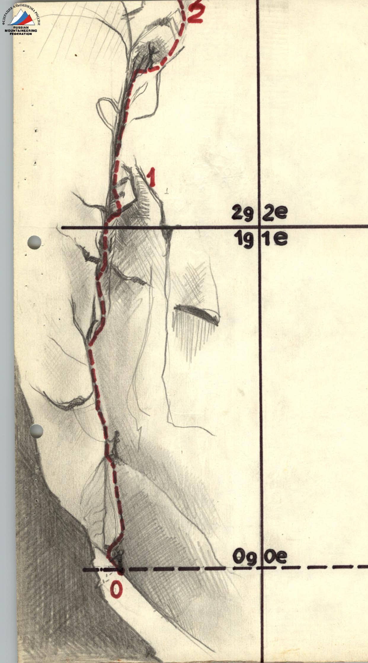
3. Ascent Description
On July 17, the team organized a base camp at the terminal moraine of the glacier in a safe and convenient location, one day later than scheduled, due to the absence of a car.
July 18. A detailed reconnaissance was conducted, inspecting the route and photographing it from different points of the cirque.
July 19. The group started the route in separate pairs (in time), due to the need to establish a radio connection with the Uzunkol tourist center in the morning. This connection was related to the need for precise antenna orientation and required the presence of four people. One observer alone could not handle this task.
At 6:30, the first pair — Tsymbal, Kolyshkin — left the base camp. The previous night was very cold, and progress to the start of the route along the glacier was slowed by hard snow. Carrying a heavy load, the pair reached the route by 9:00 and soon began its ascent, overcoming a steep snow slope with a small bergschrund. Tsymbal started working first. From the first meters, the route begins with interesting climbing on the wall with an internal angle, turning into a crack in places.
At 14:00, the second pair left the base and, upon reaching the route, began performing the unappealing but necessary task of transporting goods along the wall. By evening, the group reunited on a small ledge, where they could arrange a sitting bivouac without using hammocks. Of course, it would have been more comfortable to sleep in hammocks, but they didn't want to drill into the granite wall, and there were no natural cracks for hanging hammocks.
By 21:00, everything was ready: a hot meal made from sublimated meat and onions, sandwiches with caviar, and warm water with chocolate instead of tea.
On this day, Tsymbal first passed 120 m, then Kolyshkin took over and passed another 60 m.
180 m on the first day was not too much, but not too little either, considering the significant weight of water the team had to transport.
July 20. The working day started around 7:00 AM after a hearty breakfast.
Kolyshkin continued working first, in a rope team with Tsymbal. The team moved faster, having already consumed 7 liters of water and 2 kg of food.
By 16:00, the group reached a spot suitable for a sitting bivouac. It was decided to set up an overnight stay here, after which a further reduction in load by another 8 kg was expected, and consequently, a greater acceleration of movement. However, since there was still plenty of daylight, the Nepomnyashchy-Tsymbal pair continued the route and covered another 100 m on that day. The decision proved correct: at the end of the passed section, the group found a ledge, but it was not suitable for a bivouac due to the danger of a large slab collapsing directly above it.
The pair descended to the bivouac using the hung ropes. On this day, 280 m were covered. The group significantly increased its speed, although two sections with overhangs were passed in the latter part of the day, requiring significant effort to overcome using free climbing.
July 21. With normal backpack weights, the group quickly retraced their steps and began ascending the most complex part of the route.
After 160 m of free climbing on steep and overhanging rocks, the group approached the pre-summit tower, spending about 8 hours of intense work by the entire team.
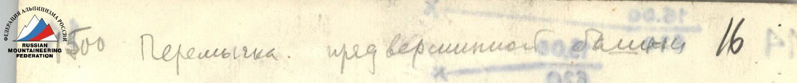
From here, the descent path into the neighboring cirque was clearly visible, so all backpacks were hung on pitons, and the group, in autonomous pairs, began moving lightly towards the summit. At 16:00, the first climber reached the summit, and at 16:20, the last participant.
Leaving their note, they began a quick descent to be able to cross back into the northwestern Nakhara cirque by 20:00 and report to observers via radio.
After two athletic sections from the base of the pre-summit mountains, on a ledge, they again distributed the load into four backpacks and began a quick descent. By 19:30, they were on a ridge connecting Dvuzubka to the west. After 20 minutes, they descended to the final obstacle — a steep snowy slope with a bergschrund; glissading was dangerous! Chock stones came to the rescue again. Seconds — and three minutes before the radio check-in, observers saw the first participant descending onto the glacier. By 21:00, the group was back at the base camp.
From July 22 to July 26, the group, at the request of the head of the championship's rescue team transmitted via radio, observed the "Spartak" team.
On July 27, at 6:40 AM, the first participants of the "Spartak" team descended to the cattle shed, after which both teams headed to the Uzunkol tourist center.
Ascent Route Characteristics Table
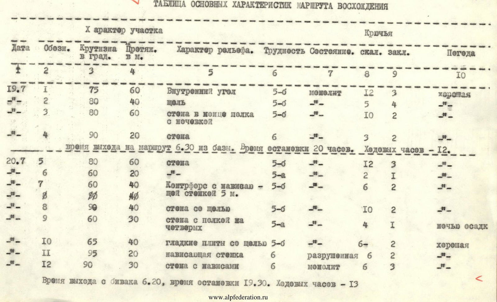

| Date | Section | Steepness | Length | Relief Character | Difficulty | Condition | Pitons | Chocks | Weather |
|---|---|---|---|---|---|---|---|---|---|
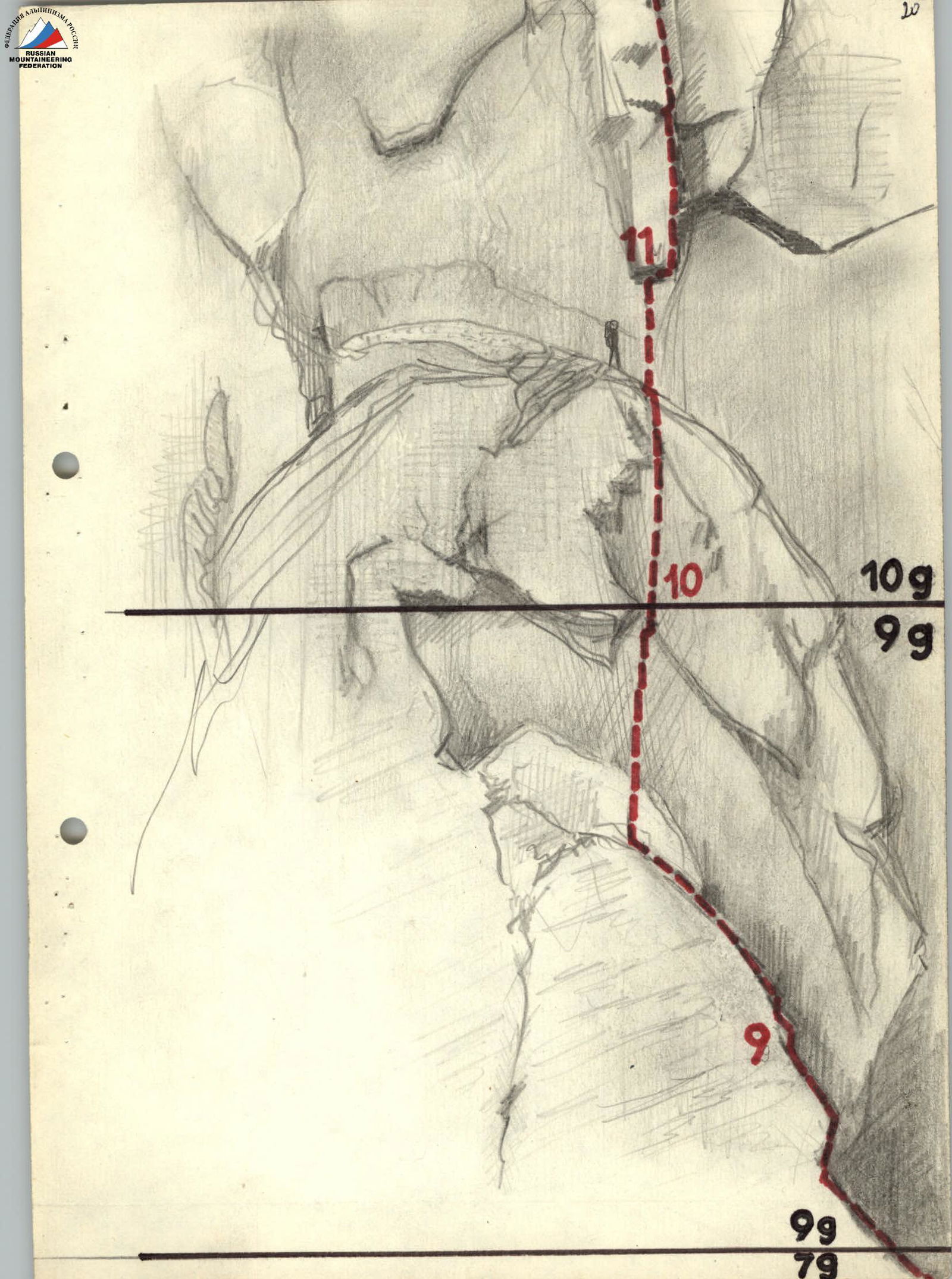
| 19.07 | R1 | 75° | 60 m | Internal angle | 5–6 | monolithic | 12 | 3 | good |
| R2 | 80° | 40 m | crack | 5–6 | – | 5 | 4 | – | |
| R3 | 80° | 60 m | wall at the end of the ledge with overnight stay | 5–6 | – | 10 | 2 | – | |
| R4 | 90° | 20 m | wall | 6 | – | 3 | 2 | – | |
| Time of departure from base 6:30. Time of stop 20:00. Climbing hours – 12. | |||||||||
| 20.07 | R5 | 80° | 60 m | wall | 5–6 | – | 12 | 3 | – |
| R6 | 60° | 20 m | 5 | – | 2 | 1 | – | ||
| R7 | 60° | 40 m | Counterfort with overhanging wall 5 m | 5–6 | – | 6 | 2 | – | |
| R8 | 90° | 40 m | wall with crack | 5–6 | – | 10 | 2 | – | |
| R9 | 60° | 30 m | wall with ledge for four | 5 | – | 4 | 1 | nighttime precipitation | |
| R10 | 65° | 40 m | smooth slabs with crack | 5–6 | – | 6 | 2 | good | |
| R11 | 95° | 20 m | overhanging wall | 6 | destroyed | 6 | 2 | – | |
| R12 | 90° | 30 m | wall with overhangs | 6 | monolithic | 6 | 3 | – | |
| Time of departure from bivouac 6:20, time of stop 19:30. Climbing hours – 13. | |||||||||
| 21.07 | R13 | 90° | 20 m | wall with overhangs | 6 | monolithic | 3 | 1 | good |
| R14 | – | 20 m | traverse along the wall | 5 | – | 2 | 1 | – | |
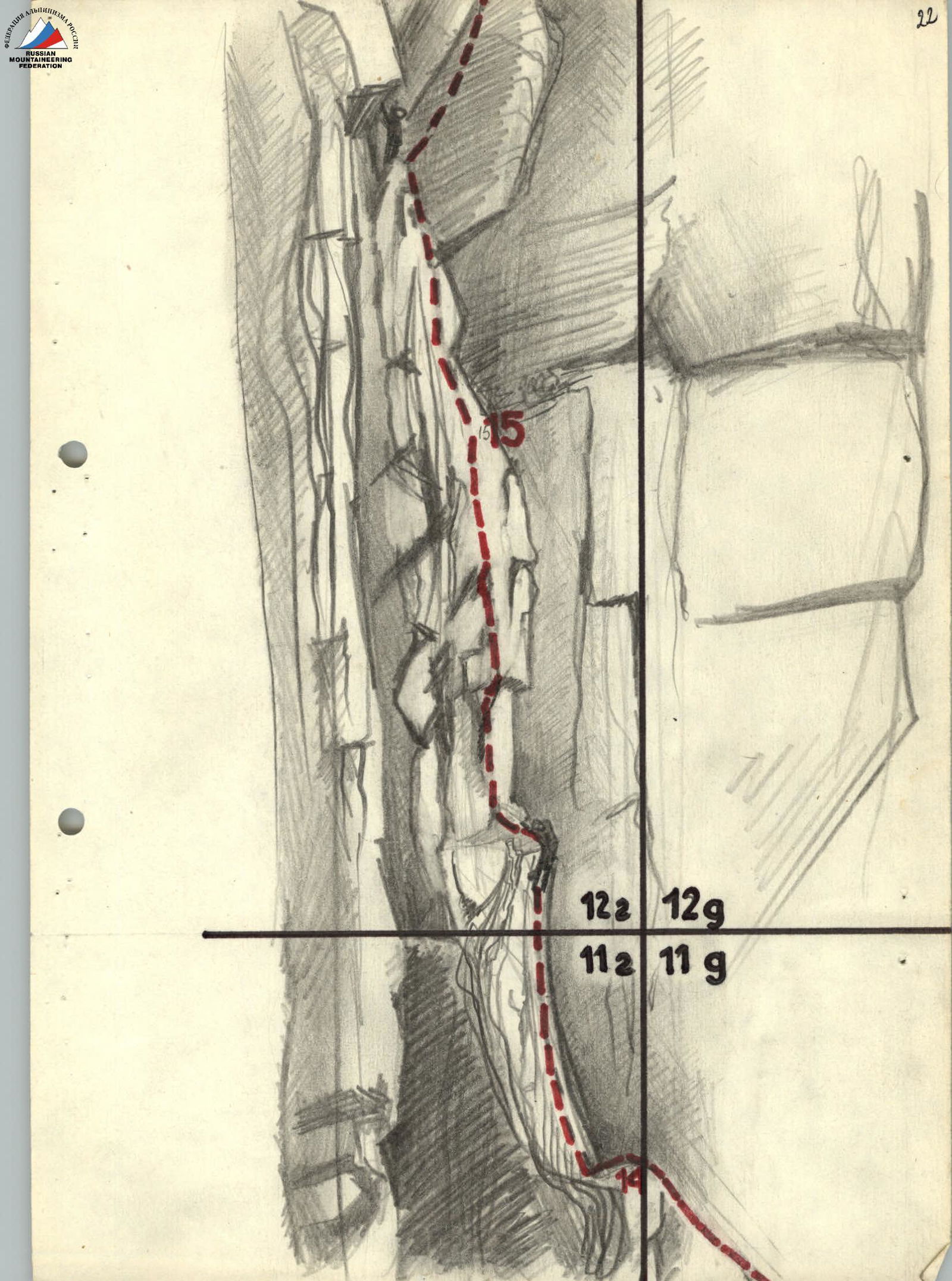
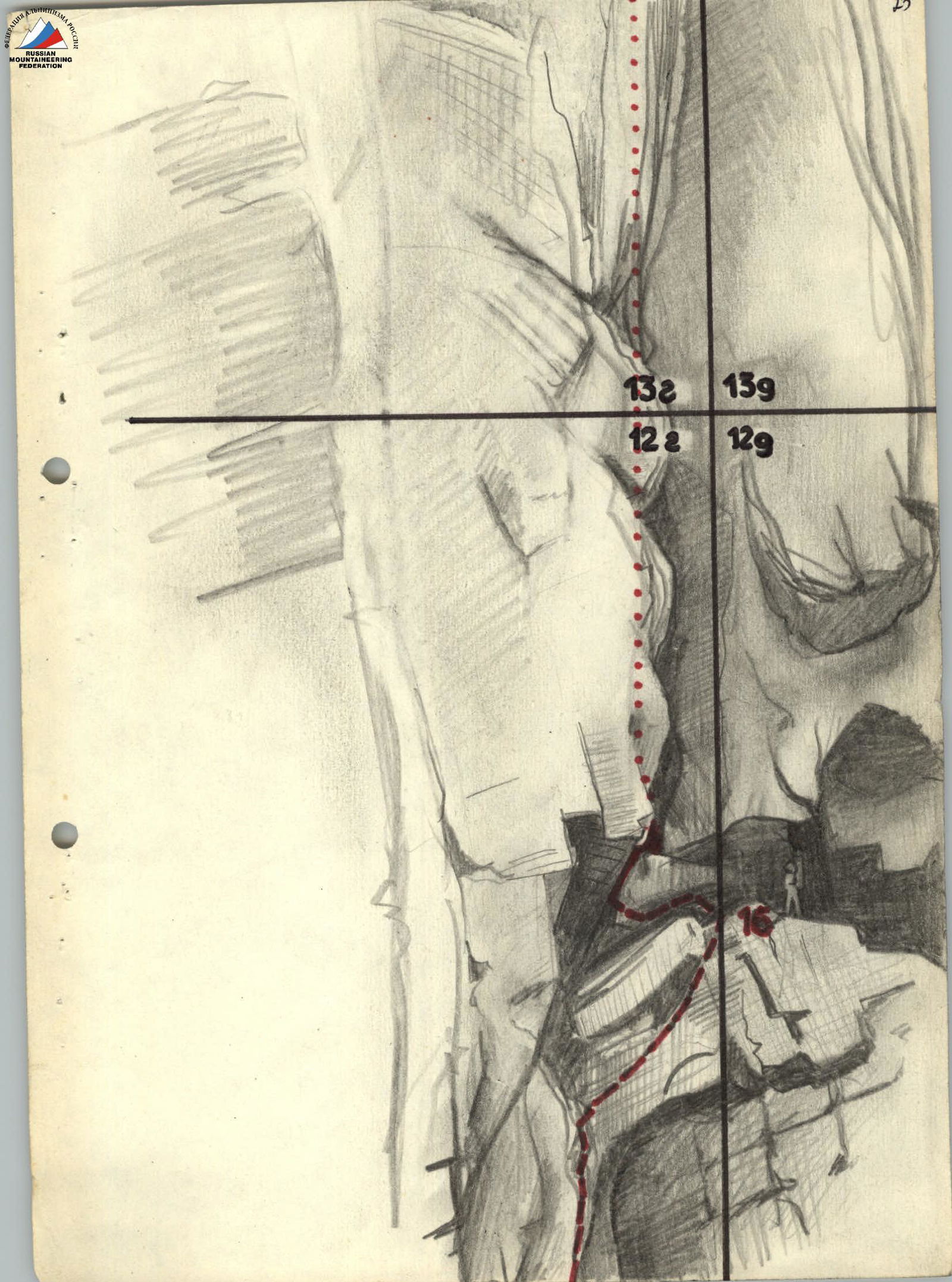
| R15 | 90° | 40 m | wall | 6 | – | 8 | 1 | – | |
| R16 | 95° | 40 m | overhanging crack | 6 | – | 5 | 4 | – | |
| R17 | 90° | 40 m | wall with overhang | 6 | – | 6 | 2 | – | |
| R18 | 80° | 20 m | wall on the ridge | 5–6 | – | 4 | – | – | |
| R19 | 80° | 60 m | bypassing a pinnacle | 5–6 | – | 2 | 5 | – | |
| R20 | – | 40 m | ridge | 2 | – | – | – | – | |
| R21 | 70° | 40 m | chimney with a cork | 5–6 | – | 1 | 4 | – | |
| R22 | 60° | 40 m | wall | 5 | – | 1 | 2 | – |
Time of departure from bivouac 7:40. On the summit at 16:00, at the base camp at 21:00. Climbing hours to the summit 8 h 20 min.
Total:
- Route length 820 m.
- Average steepness – about 75°
- Pitons driven – 114
- Chocks used – 47
- Climbing hours – 33.5 h
- Route height difference – 550–600 m
- Number of overnight stays – 2
Snow conditions: snowy.
 []www.alpfederation.ru↗
 ↗
↗
 ↗
↗
 []www.alpfederation.ru↗
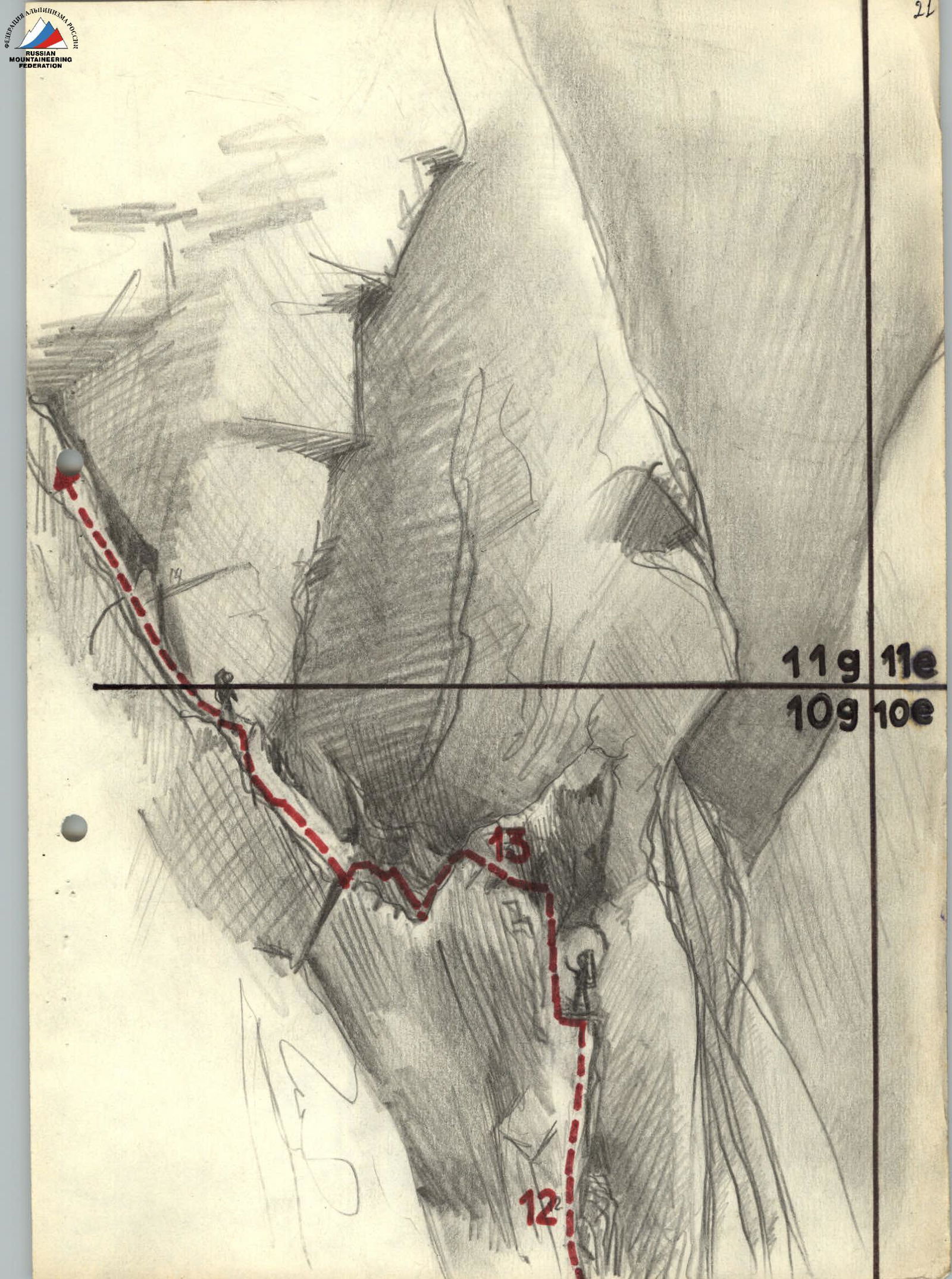 ↗
↗
 ↗
↗ []www.alpfederation.ru↗
 ↗
↗


