To the Classification Committee of the USSR Alpine Federation
Western Dvoynyashka peak via the south-eastern wall, category 5B, first ascent
Team from Krasnoyarsk "Spartak" Coach: MS ROZHKOV V.V.
VLODARCHIK N.G. - team leader
Team members:
- ROZHKOV V.V.
- VORONKOV D.A.
- PRUSAKOV S.M.
- GUDKOV V.S.
- SAKHAROV V.N.
August 19-23, 1968
PITONS WERE DRIVEN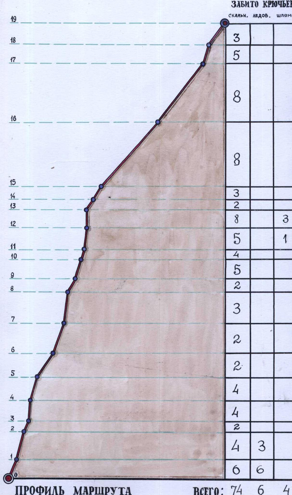 The team members used 40 m ropes and had a reserve of:
- 80 m of rope
- 20 m ladder, which was used on steep sections.
The use of such a ladder, given the difficult task of pulling up backpacks, saved a lot of energy for the climbers.
A block-brake was also used. The climbers' footwear was mostly "Vibram" type boots. Only two team members wore "otrikon" boots.
Ascent Description and Route
On August 19, 1968, at 10:30, the team consisting of:
- ROZHKOV,
- VORONKOV,
- VLODARCHIK,
- PRUSAKOV,
- SAKHAROV left the Uzunkol alpine camp and, without backpacks, followed the trail leading to the Myrdy gorge.
GUDKOV, leading a horse loaded with their backpacks, walked ahead of the team by about 30 minutes.
The approach along the flat valley of the Myrdy gorge is beautiful but quite long. So, they decided to take a small luxury and walk lightly for 3 hours along the picturesque banks of the Myrda river to the foot of the Dalar glacier.
The valley is wide and pleasant in good weather, reminiscent of Siberia, especially its eastern part.
The team covered the distance from the Uzunkol alpine camp to the moraine, where the Dalar and Myrdy glaciers meet, in 2 hours without their backpacks. Here, they unloaded the horse and began to act as its replacement.
It seemed that the horse was relieved to see them taking on the heavy loads.
They crossed the moraine tongue from right to left and began a slow ascent along the ridge of the left moraine of the Dalar glacier.
The "Kirpich" peak looked imposing with its steep, black walls blocking half the sky.
The ascent along the moraine ridge took about 1.5 hours. Before the last snow couloir, they turned left (the moraine ended in steep walls about 20-30 m high) and followed the snow, and in the upper part, a steep grassy slope, circumventing the rocks.
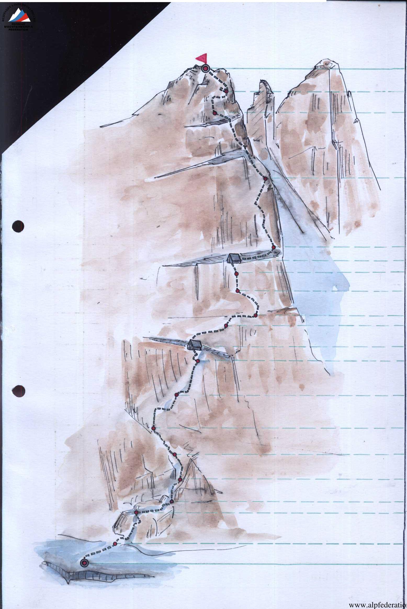
South-Eastern wall of Western Dvoynyashka peak
Route path A Biwak sites
Section 5-10 is shown incorrectly. See the next photo.
The sun was burning mercilessly, and sweat was pouring into their eyes. After ascending the grassy and talus slope at the exit to the glacier (second stage), they took a half-hour break at 16:00.
They reached the glacier and began moving towards the DASH (Dalar) pass. To their left, the south-western wall of Dalar peak - recently ascended by a group of instructors from the camp under the leadership of Master of Sports B.N. Korablin - towered in all its grandeur, lit by the sun. The side lighting allowed them to examine the wall in detail, noting all possible and impossible ascent routes. It was a rich wall! The snow on the glacier was wet, making it easy to walk due to the thin snow cover of no more than 15 cm. In the upper part, before the pass, they roped up, with GUDKOV, wearing "otrikon" boots, leading the way, and stepped through the bergschrund using footholds and with insurance.
On the Dalar pass (around 6 pm), they decided to set up a camp. This was more convenient than going under the route for several reasons:
- suitable platforms;
- availability of water;
- possibility of radio communication with the camp;
- ability to prepare food in daylight.
Under the route, i.e., under the walls of Dvoynyashka, all this became either impossible or uncertain. Moreover, it was only a 30-minute walk to the route after resting.
They pitched tents, prepared dinner. VORONKOV attempted to contact the camp via radio, but even with the help of a traveling wave antenna, they were unable to establish a connection. Probably, the walls of "Dvoinyashka", "Dalar", and "Trapezia" were screening their signal.
They had dinner and, at 21:00, after preparing tea for the next morning, went to bed.
August 20, 1968. They left the camp under the Dalar pass at 5:00. Descending the gentle firn slope with a traverse to the left was pleasant and quick.
In 25 minutes, they approached the Dvoynyashka peak and, after crossing a low counterfort descending from the southern part of the Western peak, went down along the grassy ledges and the beginning of the talus couloir on the south-eastern wall of Western Dvoynyashka. Here, on a wide green ledge, they left one tent, some food, and a canister with fuel. It would be useful for the return journey. They examined the route with binoculars, recorded, and photographed it. They took a second breakfast in the meantime. The weather was magnificent. It was hard to believe that just a week ago, they were battered by snow, wind, and rain on this very peak.
They began their ascent along the planned route at 10:15. The first rope team consisted of:
- VLODARCHIK–PRUSAKOV
- SAKHAROV–GUDKOV
- ROZHKOV–VORONKOV
The path followed a vertical line up to a giant detached block, and then along the second (main) wall to the peak. The wall was approximately 600-700 m high. It was difficult to determine the exact height due to the overlapping steep sections, and even a close examination with binoculars did not provide a clear answer.
The wall looked impressive - a solid monolith with faint, gentle ledges. They ascended a steep, complex couloir with a wide mouth to the base of the black wall, where they left the first cache with a note stating that the route began here. From there, they turned left along a narrow couloir, which turned into a chimney at the top, to circumvent the black monoliths. They had to be cautious in the couloir:
- There were many loose rocks.
- Rocks could fall from the upper chimney due to careless movements of the lead climber.
They moved slowly.
6 pitons were driven on a 30 m section. The entire detour was about 120 m. The rocks in the chimney were complex.
They reached a ledge with snow on it. The ascent took 3.5 hours.
From the snow on the inclined ledge, they ascended to the wall and traversed left along it. Complex rock climbing began. The sound of pitons and hammering was constant. Ladders were used.
8 pitons were driven on a 20 m section. From the green ledge, they ascended left and upwards along a vaguely defined angle to a small overhanging cornice.
The angle was about 60 m (10 pitons, use of ladders).
A belay rope was established. They quickly ascended and pulled up their backpacks. The block-brake worked well. On steep walls, it was an indispensable aid in such tasks.
From under the cornice, they followed a crack (a very complex key section of the wall) directed to the right to a small platform (40 m of steep climbing).
11 rock pitons, 1 ice piton, and 3 wooden wedges were driven.
They frequently hung ladders. On the platform, they left the second control cache. Above the cornice, they left a wooden wedge with a loop and 2 corks.
From the platform, they ascended directly upwards under an overhanging cornice and then to the right for 3 m. The rocks were like "ram's foreheads". There were very few cracks for driving pitons. The thorough preparation of the iron part of their equipment (various pitons) and a specially made "cartridge belt" for pitons, worn by the lead climber, proved justified. Pitons were easily extracted from their sockets, sat firmly in them, and, most importantly, with a considerable number (26), did not restrict movement.
The movement was slow. The lead rope team, VLODARCHIK–PRUSAKOV, chose a path along the steep monolith with rare, narrow ledges, sharply inclined away from the wall.
Finally, they reached a wide, inclined ledge, where they could accommodate the rest of the team. The rope team ROZHKOV–VORONKOV ascended, replaced the belay, and moved right along the ledge for 30 m (piton insurance!) to the base of the gray-black wall with a noticeable detached rock at the top. They traversed the wall to the right and upwards. The holds were small but monolithic. At the top of the wall, there was a small vertical crack.
After the wall (25-30 m), they reached a wide talus ledge. It was the head of the detached monolith. There was snow. The platform was large enough for a bivouac. They set up camp.
They prepared dinner in the dark. The entire path from the start of the route to the bivouac took 9.5 hours. 68 pitons were driven. The weather was perfect. They settled in for the night as follows:
- Four: ROZHKOV, VLODARCHIK, SAKHAROV, GUDKOV - in a "Pamir" tent wearing down-filled jackets.
- In a tent set up on an ice axe "Zdarka" - VORONKOV and PRUSAKOV in down-filled sleeping bags.
The sky was starry, and the morning promised to be good.
August 21, 1968
They rose at 5:00, prepared breakfast, and held a meeting.
It was clear that they couldn't complete the wall in one day. This became obvious when they approached the wall closely. They decided not to dismantle the bivouac but to ascend as high as possible and prepare the path. With a sufficient supply of pitons and ropes, as well as a 20 m ladder, they could process 200-250 m of vertical ascent in a day. After a hearty breakfast, the rope team ROZHKOV–VORONKOV, guided from below by the rest of the team, began processing the main wall.
From the bivouac, they ascended 50 m along easy rocks to the base of a snow couloir between the Western and Eastern peaks. The couloir was steep and dangerous. Rocks and ice frequently fell from the steep walls of both peaks.
The route began directly up the wall with a negative angle from the talus ledge.
A piton was driven from the shoulder of a teammate, and a ladder was hung. Even with this, the ascent required significant strength. Then, they ascended along the angle to an overhanging cornice (40 m - 12 pitons) and from under the cornice, traversed right along a narrow ledge (7 m - 3 pitons). They used ladders and artificial holds. Some pitons necessary for the second ascent and descent were left in place.
Along the ledge, they ascended under a steep angle (15 m - 4 pitons). After the angle, they traversed right along a smoothed, steep outer angle and a detached slab, and then continued with strenuous, strength-demanding climbing along another steep angle, reaching a platform where four people could gather.
The entire path, about 100 m, took 4.5 hours.
The rope team PRUSAKOV–VLODARCHIK followed and continued processing the route. VORONKOV and ROZHKOV descended to the bivouac along the left pitons and ladders at 12:30. The rope team VLODARCHIK–PRUSAKOV continued processing the route.
After the platform, they ascended directly upwards for 2 m and then traversed right to a narrow ledge, and from there, upwards again along an inclined angle.
The climbing was complex, with the use of ladders. Further, along the angle, they reached an overhanging cornice, which was taken head-on.
The next obstacle was a vertical (90°) wall of solid monolith with rare, small cracks, leading to a fairly large but inclined ledge. The entire section was about 40 m. 25 pitons were driven. The wall was climbed exclusively on ladders. On the ledge, they left the third control cache. A semi-reclining overnight stay was possible, but there was no water.
Generally, there was no water on the wall, except for the site of the first bivouac, as they later found out. This should be taken into account by future climbers.
The rope team descended to the bivouac from the third control cache, as it was already around 6 pm.
There were still 200-250 m of unprocessed wall ahead. The descent took until 20:30, and they descended in the dark. The 20 m ladder hung by the rope team ROZHKOV–VORONKOV at the very bottom proved helpful, significantly speeding up their movement on the steep sections where the lead climber used three-step ladders.
The descent ended in the dark, but the headlamps they were equipped with allowed them to work on the rocks, albeit at a slower pace than in daylight.
The descending rope team was greeted with a hearty dinner and plenty of hot tea. They ate, drank, and went to sleep. They had covered 2/3 of the route, but they felt the most challenging work on the steep sections ahead.
Throughout the route, the team maintained contact with the camp through a relay - climbers from the Dnipropetrovsk Alpine Club, who were ascending the "Dvoinyashka" from the north via route 4B.
They occasionally appeared against the sky on their descent, saw the team, but couldn't communicate without a radio.
August 22, 1968
They rose early, at 3:30 - ahead was a challenging day, and they needed to hurry. The weather began to deteriorate.
Rare clouds were gathering in the sky, but it was clear that within a couple of days, if not snow, then definitely rain could be expected. Getting wet on the wall was not an appealing prospect.
The rope team VLODARCHIK–PRUSAKOV, both wearing "Vibram" type boots, went ahead. They found it easier to climb the rocks.
The rest of the team began a slow ascent with the pulling of backpacks along the processed part of the route to the third control cache. Here, they fully appreciated the advantage of the 20 m ladder. The ascent to the ledge where the third control cache was left took about 6 hours for the entire team.
They carried 4 liters of water with them. If they couldn't reach the summit today, they would have to spend the night sitting on the ledge.
Upon reaching the ledge, they saw that the first rope team had processed about 60 m of the wall and was driving in expansion pitons.
From the ledge, the route continued:
- right along the wall, traversing 5 m;
- then directly upwards 8 m to a horizontal ledge 5 m long.
Along the ledge, right 3 m to a large inclined angle 10 m, and up it to a gray inclined slab with three black stripes. It was a very complex section. The approach to the gray wall was via expansion pitons (3 pitons). From the gray wall, left and upwards along a steep left angle with a crack (complex section, ladders) 40 m, they reached a large rock ledge under a big yellow cornice (20 pitons driven).
From the ledge, the route could be seen in two ways:
- directly through the cornice and then 60 m of monolith with the use of expansion pitons - to the summit;
- or to turn left onto a talus ledge with a sharp traverse of 40 m along a narrow (15-20 cm) ledge under the bifurcated gray wall on the ridge.
They chose the second option after consulting, as they didn't have enough expansion pitons, and there was no suitable platform, and working on ladders was quite challenging. They decided to try the second option. On the ledge, they left the fourth control cache and moved along the "psychological" wall to the left to the foot of the 80 m gray wall with easy climbing (8 pitons), leading to the summit. The wall completed the category 5A route to the Western Dvoinyashka peak.
The time was 14:00. They ascended to the summit and decided to begin their descent via the known route, as four team members had previously traversed the "Kichkinikolskaya podkova".
Contrary to their expectations, it became clear by 11:00 that the weather was not going to deteriorate, and it was very pleasant to descend along the warm, monolithic rocks in the rays of the setting sun. They descended relatively quickly despite their great fatigue. Probably, the team's morale was high.
By 18:00, the group had safely descended to the overnight site under the 5A category route.
August 23, 1968
In the morning, they left the bivouac at 7:00, ascending the inclined snowfield towards the saddle between the Dalar and Dvoinyashka peaks. They moved cautiously, as the excellent weather of the past week had made the firn icy, and there was also rime ice on the rocks and "ram's foreheads".
By 9:00, they reached the saddle, from where they contacted the camp. Everything was fine. From the saddle, they descended to the snowfields, and then the rope team VORONKOV–PRUSAKOV went to remove the remaining tent, and the entire group proceeded to the Dalar pass. Here, they prepared lunch, allowed themselves to sunbathe for 40 minutes, and then descended to the alpine camp along the valley of the Myrda river.
They arrived at the camp at 16:00, where they were greeted by friendly faces.
Route Conclusion
The route along the south-eastern wall of the Western Dvoinyashka peak is a logical and extremely complex route. The wall is about 600 m high, and a significant part of it, about 400 m, is climbed on a 90° steep slope. There are practically no suitable bivouac sites on the wall, nor is there water, which should be taken into account by future climbers.
Free climbing, except for the last ridge wall, is absent.
The constant use of:
- ladders
- artificial holds
- backpack pulling
This ascent route on the Dvoinyashka wall requires specially selected equipment and excellent mastery of all rock climbing techniques. When selecting the "iron" part of the equipment, one should consider a double number of pitons of various profiles, preferably flat titanium pitons and boxes.
The team of climbers from Krasnoyarsk "Spartak" believes that the route should be classified as category 5B and should not be recommended as a routine ascent of this category for climbers without sufficient experience in wall climbing. It should also be noted that under poor or even average weather conditions, this route is practically impassable, as a significant part of the path is traversed on friction and small holds.
The team completed the entire route in 3 days, 37 working hours. 170 pitons and 31 wedges were driven, not counting the pitons left on the descent from the summit via the 5A category route.
The high morale of the team, the many years of camaraderie among the team members, and friendly relations all contributed significantly to the successful completion of the complex wall ascent.
Conclusion on the Climbers
PRUSAKOV S.M. - excelled in all rock climbing techniques, led on many complex sections.
ROZHKOV V.V. - was physically and technically well-prepared for wall climbing. As the team's coach and having extensive experience in such ascents, he often found the most correct path on the wall.
VORONKOV D.A. - mastered alpine techniques well. Worked reliably on steep sections and insured his teammates.
GUDKOV V.S. - was physically very strong and possessed outstanding rock climbing skills.
SAKHAROV V.N. - easily climbed complex rock and ice sections of the route. Was physically well-prepared. Was the team's best cook and a considerate teammate.
Team leader CMS VLODARCHIK N.G.
Appendix No. 3
Table of Basic Characteristics of the Ascent Route along the South-Eastern Wall of Western "Dvoinyashka" Peak
| № | Average steepness of the section | Duration of the section | Section characteristics: relief character | Section characteristics: technical difficulty | Time of departure | Driven (rock) | Driven (boxes) | Driven (wedges) | Driven (expansion) |
|---|---|---|---|---|---|---|---|---|---|
| 1. | 20°–40° | 140 m | Snowfield | Insurance with an ice axe | 10:15 | - | - | - | - |
| 2. | 70° | 30 m | Chimney | Piton insurance | - | 6 | - | - | - |
| 3. | 60° | 120 m | Complex rocks with few holds | Complex climbing, piton insurance | - | 16 | - | - | - |
| 4. | 70° | 20 m | Ascent along a small ledge and wall, traversing left to the green ledge | Complex climbing, ladders, piton insurance | - | 4 | - | - | - |
| 5. | 80° | 60 m | Inner angle with a crack and few holds, leading to a cornice | Piton insurance, backpacks are pulled up | - | 2 | - | - | - |
| 6. | 80°–90° | 40 m | Steep wall with a crack (key section) | Complex climbing, pitons are driven with difficulty. Use of ladders and steps | - | 12 | - | 4 | - |
| 7. | 90° | 25 m | Monolithic rocks, few cracks. Exit to a ledge | Piton insurance. Very difficult climbing on friction along small holds | - | 4 | - | - | - |
| 8. | 90° | 30 m | Traverse left along a narrow ledge to a black wall | Piton insurance | - | 4 | - | - | - |
| 9. | 80° | 12 m | Wall with monolithic holds | Climbing of medium difficulty | - | 1 | - | - | - |
| 10. | 90° | 25 m | Traverse with ascent to the right and upwards to the head of the detached block | - | End of 1st day's work - 19:45 | 3 | - | - | - |
| 11. | 50°–60° | 50 m | Destroyed rocks | Easy climbing | 6:00 | 4 | - | 2 | - |
| 12. | 110° | 6 m | Negative angle | Complex strength-demanding climbing on ladders with pulling and stepping | - | 12 | - | 3 | - |
| 13. | 90° | 40 m | Wall with an inner angle and inclined small ledges | Very complex climbing. Use of ladders and steps. Backpacks are pulled up. | - | 3 | - | - | - |
| 14. | 90° | 7 m | Ledge 3-4 cm wide | Traverse to the right with piton insurance | - | 3 | - | - | - |
| 15. | 90° | 15 m | Inner angle with a vertical direction | Complex climbing | - | 4 | - | - | - |
| 16. | 90° | 40 m | Wall, smoothed inner angle, detached slab, platform | Very complex climbing. Use of artificial holds. Work on ladders | 4.5 hours | 20 | - | 6 | - |
| 17. | 90° | 16 m | Directly upwards and traversing to a ledge, then along an inner angle to an overhanging cornice | - | - | 4 | - | 3 | - |
| 18. | 90° | 40 m | Wall of solid monolith | - | - | 25 | - | 1 | - |
| 19. | 90° | 5 m | Wall above the ledge | Piton insurance, monolithic small holds | - | 1 | - | - | - |
| 20. | 90° | 10 m | Inclined angle | - | - | 3 | - | - | - |
| 21. | 90° | 15 m | Yellow-colored wall | Complex climbing. Monolith in the upper part without cracks | - | 3 | - | - | - |
| 22. | 90° | 40 m | Steep, vertical inner angle | Use of ladders | - | 20 | - | - | - |
| 23. | 90° | 40 m | Ledge with a horizontal traverse to the left, 15-20 cm wide | Piton insurance | - | 6 | - | + | - |
| 24. | 70° | 80 m | Gray wall. Good holds, exit to the summit | Climbing of medium difficulty | 36 hours | 8 | - | - | - |
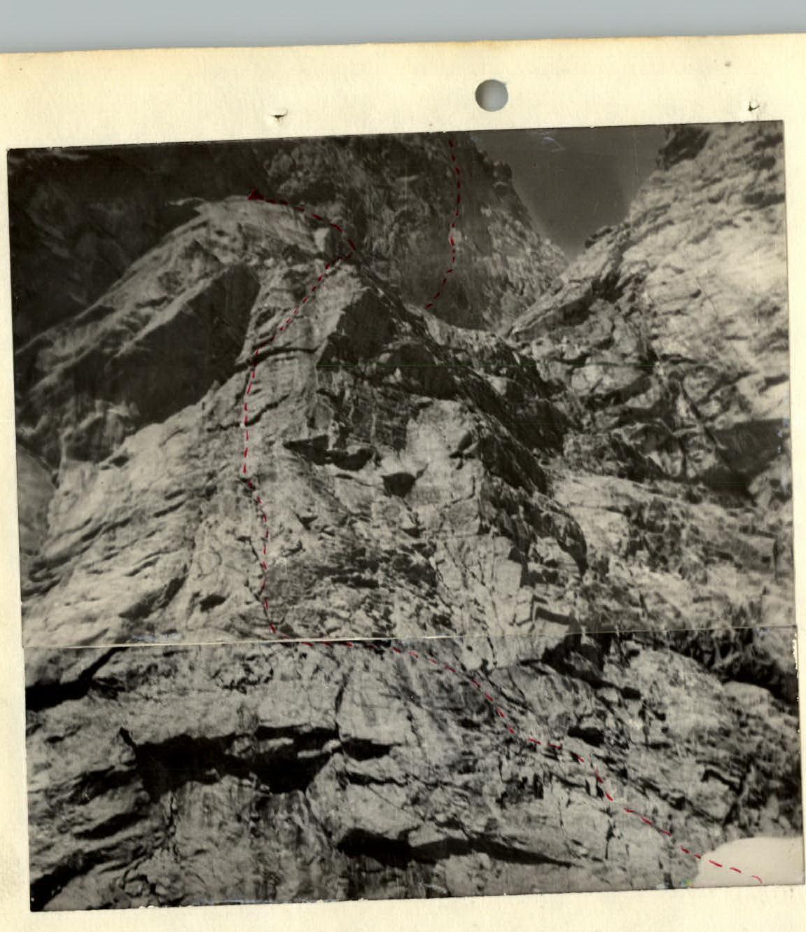
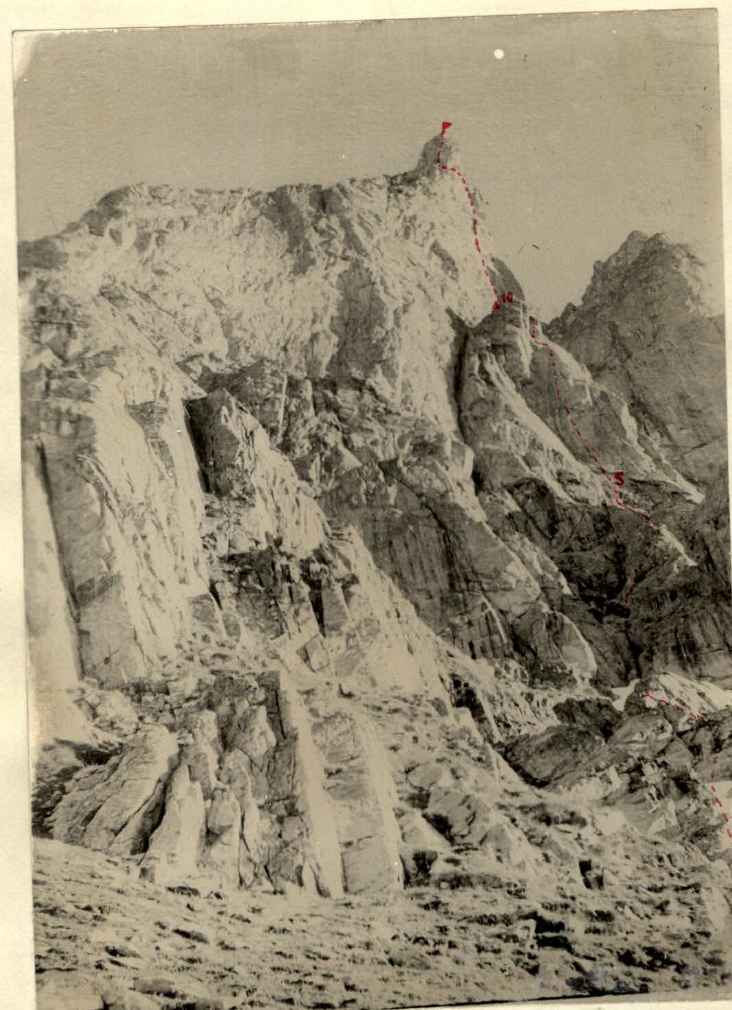
GRAY WALL OF THE DETACHED LARGE ROCK BLOCK. KEY SECTION OF THE 2nd DAY'S ASCENT (SECTIONS 5–10).
ROUTE PATH

UPPER PART OF THE WALL. 3rd and 4th DAYS OF ASCENT (SECTIONS 11–24).
ROUTE PATH
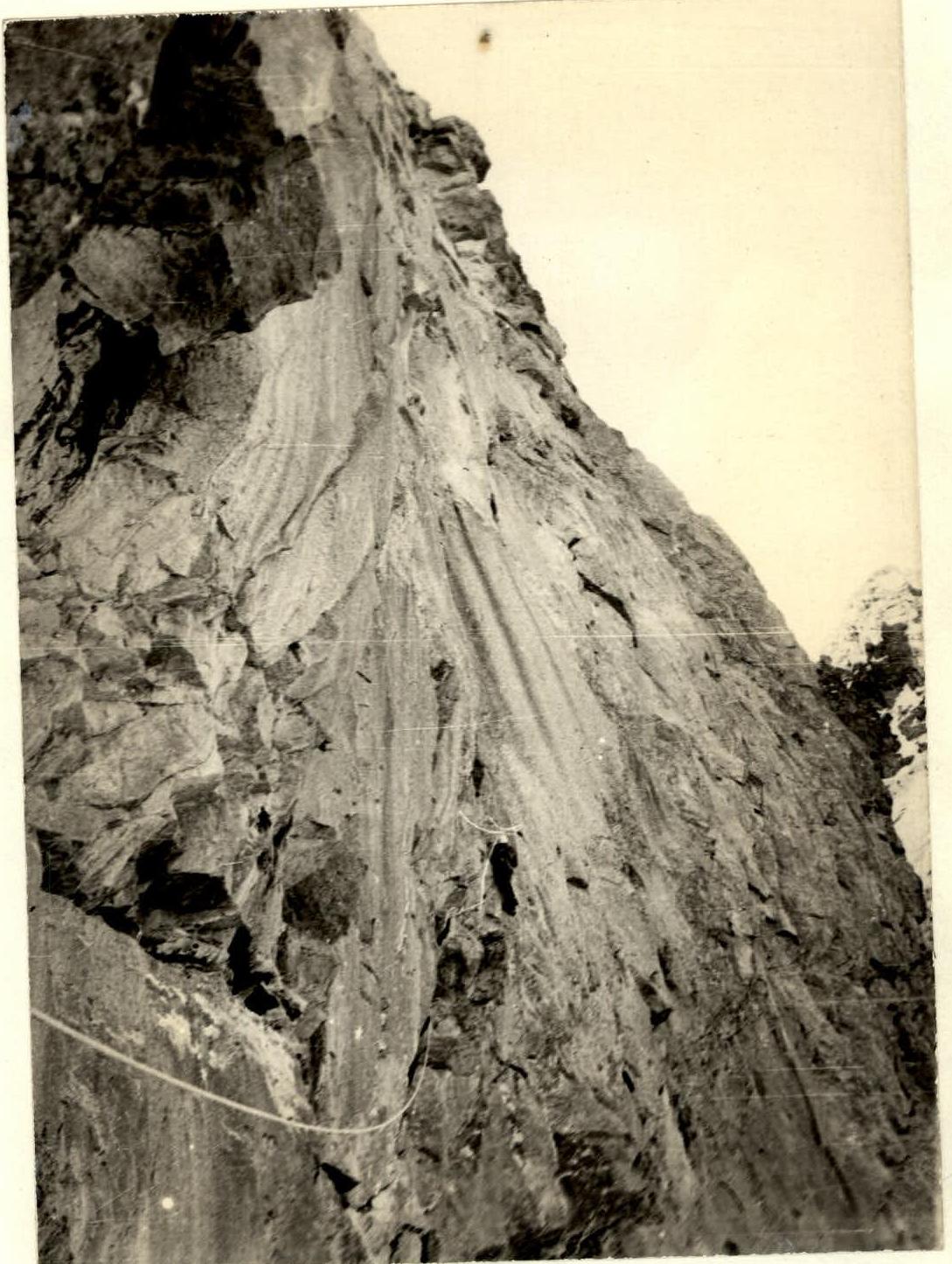
APPROACH TO THE GRAY WALL WITH THREE BLACK STRIPES (DRIVING EXPANSION PITONS).


