Ascent Passport
I. Ascent class — rock 2. Ascent area — Western Caucasus from Klukhor Pass to Chipperazau Pass 3. Peak — Vostochnaya Dvoynyashka, 3830 m 4. Estimated difficulty category — 5A 5. Route character — combined 6. Route characteristics: a) height difference 840 m b) length of sections with 4th cat. diff. 340 m c) length of sections with 5th cat. diff. 320 m d) length of sections with 5B cat. diff. 50 m e) average steepness of snow-ice part 45° f) average steepness of rock part 75° 7. Pitons hammered for belay: a) rock 39 b) ice 15 c) chocks 37 8. Travel time 16 hours 9. Overnights: on ascent — one on a rock outcrop in a tent, on descent — one on a saddle in a tent 10. Group composition:
SAVIN Boris Nilovich — CMS — leader KAROL Andrey Igorevich — CMS SAVINA Lyudmila Vladimirovna — 1st sports rank BELYAYEV Leonid Nikolaevich — CMS
- Group coach — Zakharov Pavel Pavlovich — MS
- Date of departure on the route — July 11, 1986
- Date of return — July 13, 1986
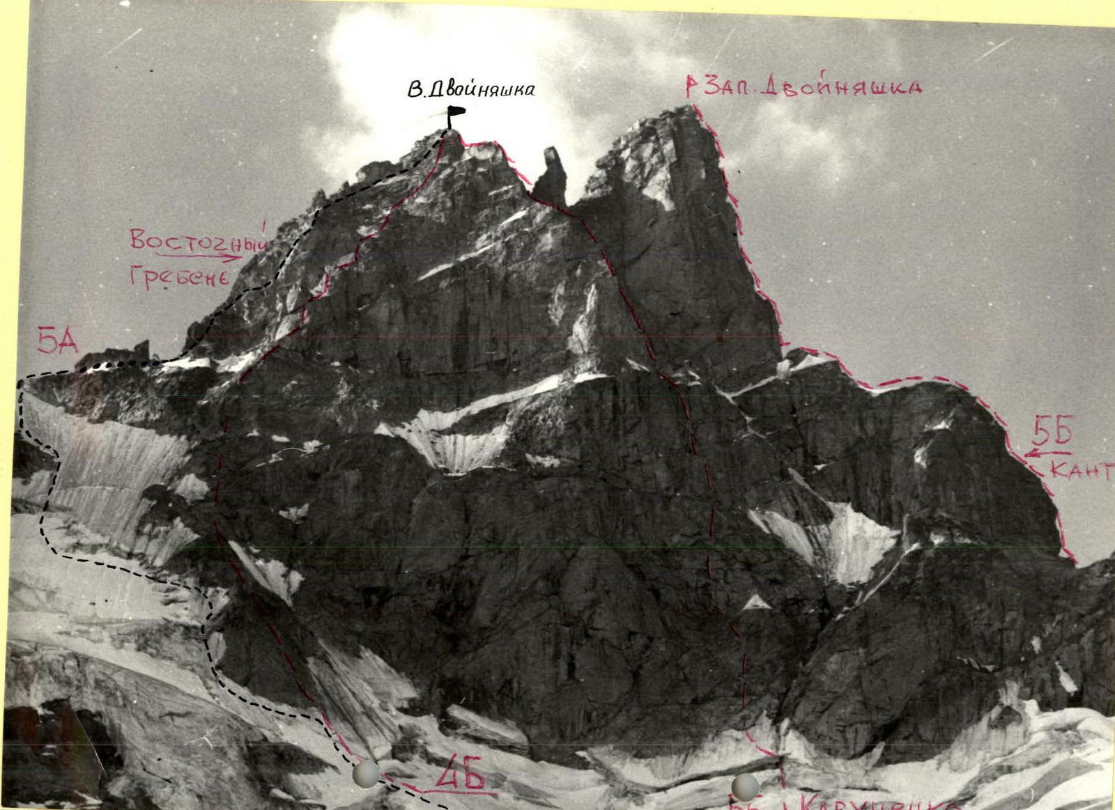 Ascent route to V. Dvoinyashka via Eastern ridge
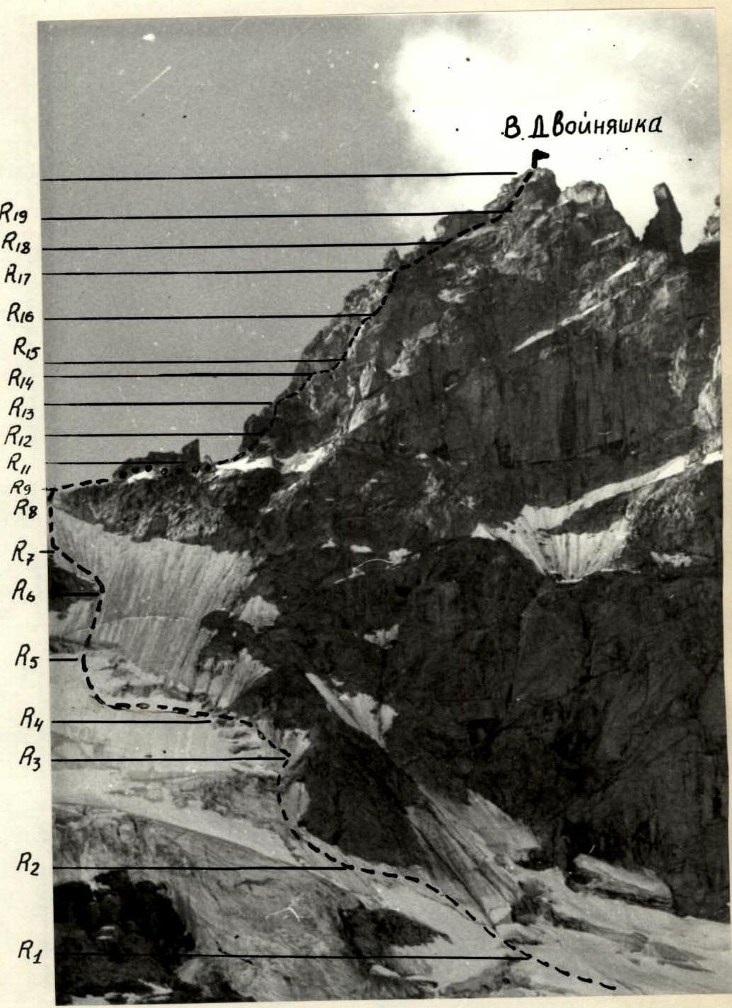
Ascent Route Profile
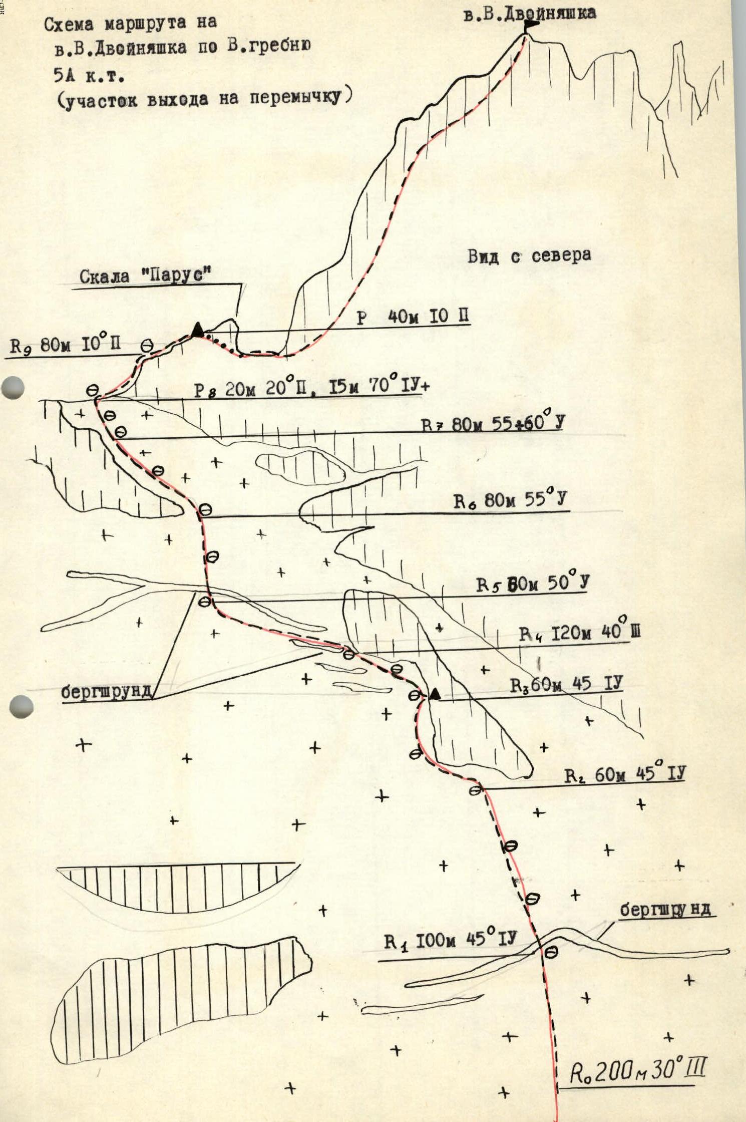
 Route scheme to V. Dvoinyashka via Eastern ridge 5A cat. diff. (section to the saddle)
Section details: View from the north. Rock "Parus". R0 200 m 30° 3. R1 100 m 45° 4. R2 60 m 45° 4. R3 60 m 45° 4. R4 120 m 40° 3. R5 60 m 50° 4. R6 80 m 55° 4. R7 80 m 55–60° 4. R8 20 m 20° 2, 15 m 70° 4+. R9 80 m 10° 2. R10 40 m 10° 2.
Route scheme to V. Dvoinyashka via Eastern ridge 5A cat. diff. (section to the saddle)
Section details: View from the north. Rock "Parus". R0 200 m 30° 3. R1 100 m 45° 4. R2 60 m 45° 4. R3 60 m 45° 4. R4 120 m 40° 3. R5 60 m 50° 4. R6 80 m 55° 4. R7 80 m 55–60° 4. R8 20 m 20° 2, 15 m 70° 4+. R9 80 m 10° 2. R10 40 m 10° 2.
 Route scheme to V. Dvoinyashka via Eastern ridge 5A cat. diff. (section from the saddle)
Section details: Rock "Parus". R11 40 m 75° 4. R12 40 m 70° 4–. R13 20 m 70° 4–, 10 m 85° 5А1. R14 20 m 75° 4. R15 40 m 80° 5А1. R16 40 m 70° 4. R17 40 m 60° 4–. R18 40 m 60° 4. R19 40 m 70° 4–.
Route scheme to V. Dvoinyashka via Eastern ridge 5A cat. diff. (section from the saddle)
Section details: Rock "Parus". R11 40 m 75° 4. R12 40 m 70° 4–. R13 20 m 70° 4–, 10 m 85° 5А1. R14 20 m 75° 4. R15 40 m 80° 5А1. R16 40 m 70° 4. R17 40 m 60° 4–. R18 40 m 60° 4. R19 40 m 70° 4–.
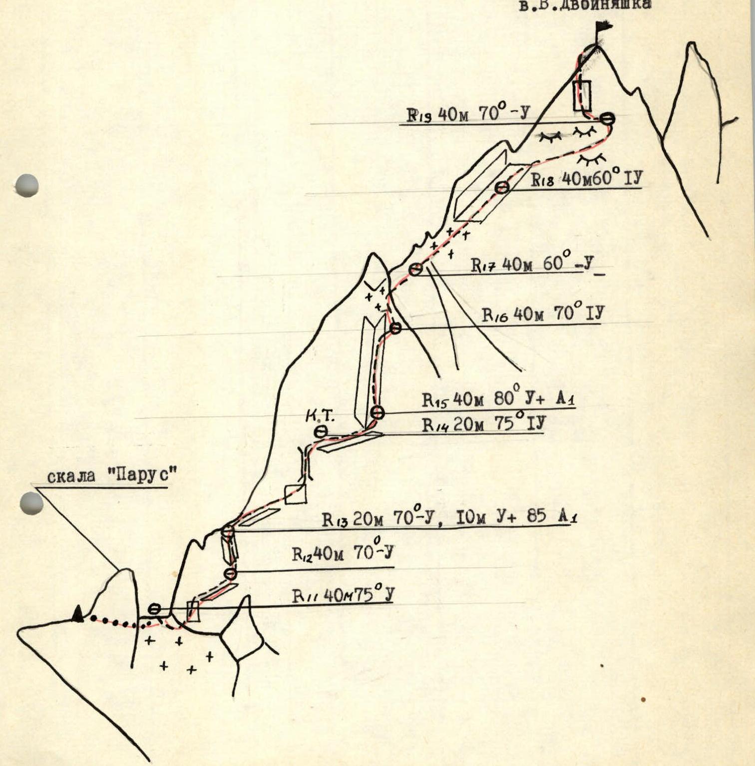
Table of Main Ascent Route Characteristics
Route — combined Height difference — 840 m Total route length — 1260 m, including:
- snow-ice sections — 820 m
- sections with 4th cat. diff. — 390 m Average steepness of snow-ice part — 45° Average steepness of rock part — 75° Number of pitons hammered:
| Piton type | Quantity |
|---|---|
| rock | 39 |
| ice | 15 |
| chocks | 37 |
| Date | Section | Average steepness | Length | Terrain character | Difficulty | Condition | Weather conditions | Rock pitons | Ice pitons | Chock pitons | Other pitons | Overnight stay |
|---|---|---|---|---|---|---|---|---|---|---|---|---|
| 11.07.1986 | R0–R1 | 30° | 200 m | slope | 1 | snowy | good | – | – | – | – | – |
| R1–R2 | 45° | 100 m | bergschrund | 4 | snowy | –"— | – | – | – | – | overnight on rock outcrop | |
| R2–R3 | 45° | 60 m | slope | 4 | snowy | –"— | – | – | – | – | ||
| 12.07.1986 | R3–R4 | 45° | 60 m | slope | 4 | dense snow | good | 3 | – | – | – | |
| R9–R5 | 40° | 120 m | slope | 1 | –"— | –"— | – | 1 | – | – | ||
| R5–R6 | 50° | 60 m | slope, bergschrund | 4 | dense snow, ice | good | – | 2 | – | – | ||
| R6–R7 | 55° | 80 m | slope | 4 | thin layer on ice | –"— | 8 | – | – | – | ||
| R7–R8 | 55–60° | 80 m | snow-ice ridge | 4 | dense snow | –"— | – | – | 4 | – | ||
| R8–R9 | 20° | 20 m | –"— | – | snow | good | – | – | – | 2 | ||
| 70° | 15 m | wall | 4+ | monolith | –"— | – | – | – | 2 | |||
| R9–R10 | 10° | 80 m | ledge | 2 | broken rock | –"— | – | – | – | 2 | ||
| R10–R11 | 10° | 40 m | ledge | 2 | –"— | –"— | – | – | – | – | ||
| R11–R12 | 75° | 40 m | wall | 4 | monolith | fog | 4 | – | – | – | ||
| R12–R13 | 70° | 40 m | inner angle | 4– | broken rock | fog | 2 | – | 5 | – | ||
| R13–R14 | 70° | 20 m | wall | 4 | monolith | –"— | 2 | – | 2 | – | ||
| 85° | 10 m | chimney | 5А1 | monolith | –"— | 1 | – | – | 3 | |||
| R14–R15 | 75° | 20 m | narrow ledge | 4 | monolith | –"— | 3 | – | – | 2 | ||
| R15–R16 | 80° | 40 m | inner angle | 5А1 | broken rock | fog | 5 | – | – | 6 | ||
| R16–R17 | 70° | 40 m | edge | 4 | –"— | –"— | 3 | – | – | 3 | ||
| R17–R18 | 60° | 40 m | slabs with ice accretion | 4 | monolith | –"— | 6 | – | – | 2 | ||
| R18–R19 | 60° | 40 m | rocks like "Ram's foreheads" | 4 | monolith | –"— | 6 | – | – | 2 | ||
| R19–R20 | 70° | 40 m | wall | 4 | monolith | fog | 4 | – | – | 4 | overnight on saddle |


