
Dalar
up the North-East wall. Team of “Trud” Sports Society Team leader: Master of Sports of the USSR Snesarev A. A. Team captain: Master of Sports of the USSR Stepanov V. V.

The summit of “Dalar”, view from the North
Brief sports characteristic of Dalar peak
The year of the beginning of the development of the Gvandra region, where the Dalar peak is located, should be considered 1936, but already in 1937 most of the peaks in this region were conquered.
Convenient approaches, picturesque valleys, sheer rocky peaks and a relatively mild climate made this area quite popular among climbers.
The first ascent to the Dalar peak via the simplest route (category 3B) was made by a group of Leningrad section of mountaineering in 1937. After the war, Dalar again attracts climbers.
One of the most interesting routes to Dalar is the North-East wall.
In the book by B.I. Delone[^0] we come across a mention of it: “... completely smooth rocky North-East wall of Dalar ...”
It is exactly how it appears to the eye and represents one of the most challenging routes in the Western Caucasus.
In 1956, two teams from the “Krasnaya Zvezda” and “Burvestnik” sports societies declared a route up the North wall (more precisely, the North-East wall) to the Dalar peak.
The “Krasnaya Zvezda” group had to abandon the route after an unsuccessful attempt.
The “Burvestnik” group led by Semenov N. M. was more successful. However, they were unable to complete the route fully. Having passed the lower part of the route and encountered sections of extreme technical difficulty, the group turned left onto the rocky ridge between the Dvoinyashka and Dalar peaks and, bypassing the summit tower, reached the summit from the south.
The section of the route passed by Semenov's group was classified by the commission of the Mountaineering Federation of the USSR as a category 5A route, although our group supports Semenov's group in their assessment of the passed route as category 5B, due to the high technical difficulty of the coinciding section of the route passed by both groups.
Our group, having started the route, had no information about the path taken by Semenov's group and did not receive any consultations on the route. In the first third of the route, the group found 2 notes from Semenov's group, which were located in a cairn at the exit from the lower shelf to the platform and at the first overnight stop. No further traces of Semenov's group were found on the route.
This gives grounds to consider that the route was passed by our group for the first time. In geomorphological terms, the Main Ridge is divided into three parts: Western, Central, and Eastern.
The Western part of this large geological structure, which includes the Dalar peak, originated in the Upper Paleozoic; it is composed of pre-Upper Paleozoic intrusive rocks, deeply metamorphosed crystalline schists of the Lower Paleozoic and Precambrian, as well as partially slate schists of the Lias. Its boundaries to the south and north are tectonic.
In the area of Elbrus and slightly to the west (i.e., in the area of the Dalar peak), an extreme compression of structures is observed. This region is the general node of virgations for the entire Big Caucasus system, developing from here to the northwest and southeast.
The Dalar peak massif is composed of so-called “gray granites”, characteristic of this section of the Main Caucasian Ridge, cutting through the thickness of the oldest formations, which are represented by various mica schists.
It is worth noting some role of vein milky white quartz in the schists. In addition, granitoids are cut by dykes of diabasic composition.
The material analyzed, taken from the wall during the ascent, allows us to state that the wall is composed of granitoids of the ancient complex, among which the following varieties are distinguished: – microcline leucocratic granite; – granite of normal composition; – muscovitized granite; – two-mica (muscovite-biotite) granite; – gneiss-like granite. In addition to the intrusive complex, rocks of metamorphic and effusive complexes were determined microscopically and in macro-samples.
Metamorphic rocks are represented by plagioclase-quartz-biotite crystalline schists.
Effusive rocks are represented by partially destroyed diabases under the influence of secondary processes.
The determination of rocks and the identification of three rock complexes — intrusive, metamorphic, and effusive — in the area of the Dalar peak massif does not contradict literary data. It is difficult to speak reliably about the age of the studied rocks composing the Dalar peak due to the limited amount of rock material taken from the wall.
Thus, the structure of the North-East wall of the Dalar peak can be represented as follows: – The main massif of the peak is composed of ancient granites, strong with a minimal number of cracks and smoothed microrelief. – In this massif, short belts of metamorphic rocks are embedded with a sharp contact, represented by strongly destroyed schists. – The location of the belts of metamorphic rocks coincides with the snow belts on the North-East wall. – In the lower part, these rocks form a significant part of the inclined shelf leading to the North-East wall. – The total height of the belts of metamorphic rocks does not exceed 100 m.
The Tertiary effusive complex, represented by partially destroyed diabases, is located with a sharp contact above the third snow belt at the exit to the summit tower. Its height also does not exceed 100 m.
The summit tower of the North-East wall is composed of well-preserved effusive rocks of the effusive complex — strong sheer rocks with a small number of cracks and no microrelief irregularities.
Sports group composition
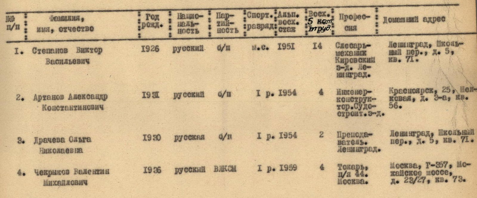
| № | Surname, name, patronymic | Year of birth | Nationality | Party membership | Sports rank | Mountaineering experience | Ascents of category 5 | Profession | Home address |
|---|---|---|---|---|---|---|---|---|---|
| 1. | Stepanov Viktor Vasilyevich | 1926 | Russian | Non-party | Master of Sports 1951 | 14 years | Fitter-mechanic | Leningrad, Shkolny per., d. 5, kv. 71. | |
| 2. | Artanov Alexander Konstantinovich | 1931 | Russian | Candidate member | 1st sports rank 1954 | 4 years | Design engineer | Krasnoyarsk, 25, Shelkovaya, d. 3-a, kv. 56. | |
| 3. | Dracheva Olga Nikolaevna | 1930 | Russian | Candidate member | 1st sports rank 1954 | 2 years | Teacher | Leningrad, Shkolny per., d. 5, kv. 71. | |
| 4. | Chekryzhov Valentin Mikhailovich | 1936 | Russian | Komsomol member | 1st sports rank 1959 | 4 years | Turner | Moscow, G-357, Mozhaiskoye shosse, d. 23/27, kv. 73. |
Ascent
July 17. At 9:00, we leave the “Uzunkol” alpine camp for the ascent. We are accompanied by a “duo” of observers. In 3 hours, we reach the Big Kichkenekol glacier. Our “base camp” is here.
From here, the observers have a good view of the entire route. The “powerful pipe” will allow them to see every step we take.
We spend the day observing the wall, although its “regime” is well studied, and the ascent route up the wall is already planned. But who knows — often seemingly easy-to-pass sections turn out to be impassable. And vice versa. Won't the wall surprise us?
We cook a good dinner, review the equipment once again, and, after clarifying the communication schedule with the observers, go to bed early.
The weather is perfect. We hope it won't let us down — the forecast is good.
July 18. The morning is clear. After breakfast, at 4:15, we start the 2nd day of the route. We ascend the Big Kichkenekol glacier and then turn right onto the “ram's foreheads”, leading to the middle of the North Dalar glacier. Along the glacier, bypassing a number of crevices, we ascend in the direction of the shelf on the north wall. The exit to the shelf is not difficult. The shelf is composed of largely destroyed rocks, but there are also monolithic sheer walls, especially at the end, which are complex to pass. Several large snowfields on the shelf are traversed either by traversing them or along the border of snow and rocks. In one place, we have to ascend via a “rantkluft” between a snowfield and a monolithic wall.
The shelf ends with a platform where the 1st control cairn (R1) is built. In the cairn, a note from 1956 by Semenov N. M.'s “Burvestnik” group is found. The platform is unsuitable for an overnight stay as it is exposed to rockfall from above.
The further ascent is carried out directly upwards with small traverses almost along the entire length to the left of the steep North-East ridge, mainly on rocks of medium difficulty with short 2–4 m sheer difficult sections.
We reach a cave (where an overnight stay is possible). From here, difficult climbing begins. Boots “don't hold”, and we have to put on gym shoes. First, a smooth sheer wall (section 5), then a smoothed vertical inner corner (section 6), and finally, one of the key points of the entire route — an inclined inner corner of smoothed slab-like rocks, filled with water (section 7).
Passing these sections, especially the last one, is very complex and requires the use of artificial support techniques. Backpacks have to be pulled up separately.
Overnight stay on a good platform built by Semenov's group under the shelter of overhanging rocks at the end of section 8.
Here is the 2nd control cairn (R2). In the cairn, the last note from Semenov's group is found. No further traces of this group are detected during the movement.
July 19. The morning is excellent. Today's task is to pass the middle part of the peak. It represents three blocks of almost sheer smoothed rocks, separated by three snow belts.
Initially, we move along stepped rocks with good holds. The higher we go, the more often we have to stop to determine the path that allows us to reach under the summit tower. There are steep smooth rocks all around. There are few cracks, and not all are suitable for upward movement. Some serve as a natural water conduit from the snow belts. Others lead to overhanging walls that are impassable with our equipment.
We ascend, sometimes traversing mainly to the left, using cracks and slab irregularities. The path to the first and then to the second snow belt is of medium difficulty.
Although the rocks are sheer, we can climb in gym shoes with backpacks; only in a few difficult places are the backpacks pulled up.
On the ledge of the North-East ridge in the area of the 2nd snow belt, we build the 3rd control cairn (R3).
The third block of rocks proves to be the most difficult. We pass a sheer inner corner, a vertical crack, and finally, sheer slabs with water flowing down them. We use piton hammers and ladders. The first climber is pulled up on a rope from below. Backpacks are pulled up separately almost along the entire length.
10 m below the 3rd snow belt, under overhanging rocks, we build a platform for an overnight stay. Here is also the 4th control cairn (R4).
July 20, 1953. We rise and have breakfast together, praising the diligence of today's cook. Today is the decisive day. We are taciturn, although each of us is concerned about the question: will we be able to pass the summit tower or will it remain unconquered again? The weather is in our favor.
From the overnight stay, easy rocks lead to a snow-ice slope. We quickly pass it along pre-dug steps and reach the rocks. Initially, the rocks are of medium difficulty. We traverse left and upwards 15 m to a wide, not clearly defined groove. The groove is exposed to rockfall from the tower. Therefore, we have to move slightly to the right of it along stepped rocks of medium difficulty with individual short difficult sections of smooth sheer rocks.
We reach smoothed rocks like slabs and “ram's foreheads”. There are few holds and supports, and we often have to use driven pitons. A sheer smooth wall is passed using ladders. Higher, the steepness of the slabs decreases, but the complexity of their passage increases. There are narrow inclined ledges where gym shoes hold, but handholds disappear.
The sun beats down relentlessly. There is no shelter from it. Being in such a “heat”, it's hard to say what's worse — frost and cold or such heat. We think the latter.
We ascend the rocks, traverse the slabs using the irregularities on them. In some places, we are forced to start working with a piton hammer. Pitons come into play. Otherwise, it's impossible to pass the smooth wall and smoothed slabs.
We reach under an overhanging wall. The only path is leftward along a smooth vertical wall. It is done on a rope fixed to a piton hammered in above.
The exit to a vertical crack through its protruding edge is very complex: the last climber is belayed by a second rope from above. Backpacks are pulled up separately. This is one of the key sections of the entire route.
Further, there are again sheer walls of an inner corner and a chimney — smoothed with a small number of holds and supports — involving very difficult free climbing using pitons as artificial supports and holds and using ladders.
At the exit from the chimney onto a ledge under an overhanging wall — the 5th control cairn (R5).
We reach the summit ridge by ascending along snow-covered smoothed slabs and then along a smooth overhanging 2-meter wall, turning into easy rocks.
Finally, everyone is on the summit. Soon, the primus stove roars to life, and after dinner, we descend from the summit via the category 3B route. We spend the night on the Dalar pass.
July 21. From the Dalar pass, we descend into the Myrdy gorge via the usual path.
By lunchtime, the group is already at the “Uzunkol” alpine camp, where we share the joy of victory with our comrades. The Dalar wall is conquered for the first time.
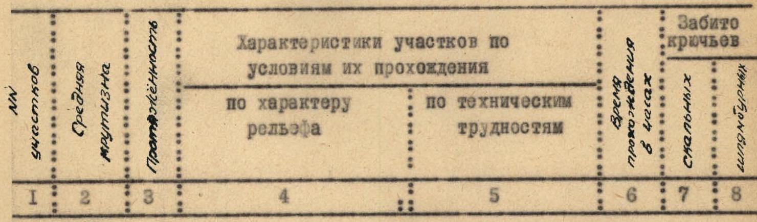
| № of sections | Average steepness | Length | Characteristics of sections according to passage conditions | Passage time | Difficulty category | Number of pitons | Number of rappel rings | Number of belay stations |
| Подъём по леднику с обходом трещин и выходом на нижнюю полку стены | 20–45° | 200 м | Glacier, rocks like “ram's foreheads”. The lower shelf of the wall is composed of destroyed rocks, with several sheer walls in the middle part. Easy climbing on the first sections, becoming more complex towards the end due to the terrain. | 0:50 | 2 | – | 2 | – |
| 1 | 60–45° | 40 м | Inner corner 60°, 10 m, formed by unstable rocks. Ascent to the right and upwards along rocks like “ram's foreheads”, then to the left, exiting onto an osypnaya shelf. Easy climbing. We ascend the inner corner very carefully due to the destructiveness of the rocks. | 0:20 | 4 | – | 4 | – |
| 2 | 60–80°
15–25° | 120 м | Shelf 0.5–2 m in very destroyed rocks, with an inclination of 45–60° (sometimes lost, and then the path goes along sheer rocks, sheer inner corners). Several steep snow sections up to 60–70°, 10–25 m. At the end of the shelf, on the platform, the 1st control cairn (R1). Climbing becomes more complex due to the unreliability of heavily destroyed rocks. The first sections are passed along the shelf, holding onto the rocks with hands. Then climbing becomes more difficult (steep 10-meter inner corner, sheer walls, etc.). | 2:10 | 5 | – | 5 | – |
| 3 | 75–80° | 50 м | Sheer monolithic rocks 80–85° with good holds. Ascent upwards 10 m, left along the shelf 2×20 m, ascent upwards along rocks 70–80° with few holds 15 m, exiting to the right along the shelf 0.5×5 m. Pleasant climbing of medium difficulty on monolithic rocks with reliable holds and footholds. In the upper part, climbing becomes more complex. | 0:35 | 2 | – | 2 | – |
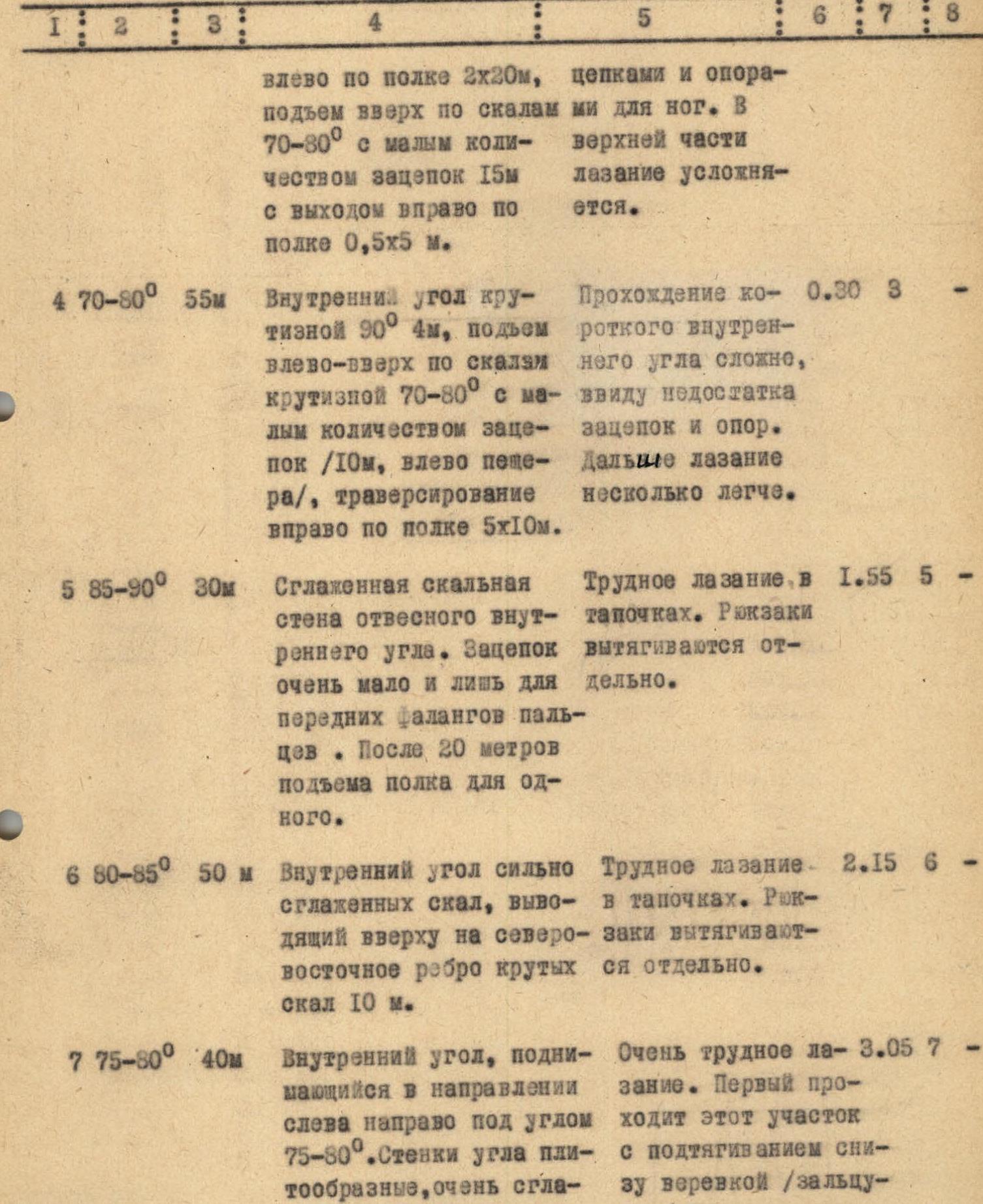
| 4 | 70–80° | 55 м | Inner corner with a steepness of 90°, 4 m, ascent to the left and upwards along rocks with a steepness of 70–80° with few holds (10 m, left — a cave), traverse to the right along the shelf 5×10 m. Passing the short inner corner is complex due to the lack of holds and footholds. Further climbing is somewhat easier. | 0:30 | 3 | – | 3 | – |
| 5 | 85–90° | 30 м | Smoothed rock wall of a sheer inner corner. There are very few holds, only for the front phalanges of fingers. After 20 m of ascent, there is a ledge for one. Difficult climbing in gym shoes. Backpacks are pulled up separately. | 1:55 | 5 | – | 5 | – |
| 6 | 80–85° | 50 м | Inner corner of strongly smoothed rocks, leading upwards to the North-East ridge of steep rocks 10 m. Difficult climbing in gym shoes. Backpacks are pulled up separately. | 2:15 | 6 | – | 6 | – |
| 7 | 75–80° | 40 м | Inner corner rising in the direction from left to right at an angle of 75–80°. The walls of the corner are slab-like, very smoothed, with almost no holds. The opening of the corner is more than 120°. The left wall of the corner is vertical, even overhanging in some places. The right wall is 2–2.5 m wide, inclined at an angle of 75–80°. Its right edge overhangs the sheer. Rocks like slabs, smoothed, filled with water. There are few cracks, and they are narrow and short. At the top, there is an exit to a sheer chimney 5 m high, leading to a ledge. Very difficult climbing. The first climber passes this section with a pull-up from below on a rope (“Zalzug”). Otherwise, they are thrown out of the corner. This is one of the key sections of the entire route. It is recommended to pass it using ladders and pitons. Pulling up backpacks is complex, as they are “thrown” by a pendulum to the right and down under the overhanging rocks, and they have to be lowered on a rope. | 3:05 | 7 | – | 7 | – |
| 8 | 45° | 6 м | Snowfield leading to an inclined shelf under overhanging rocks. Here is the 2nd control cairn (R2). Ascent in three steps using additional ice axes as supports and holds due to the softness of the snow. Backpacks are pulled up separately. | 0:15 | – | – | – | – |
| July 19 | | | | | | | | |
| 9 | 70–80° | 120 м | Sheer stepped rocks like old “ram's foreheads” with a sufficient number of holds. Overhanging sections of rocks are bypassed to the left. Climbing is mainly of medium difficulty. On two difficult sections, 20 and 30 m, the first climber has to ascend without a backpack. | 1:55 | 4 | – | 4 | – |
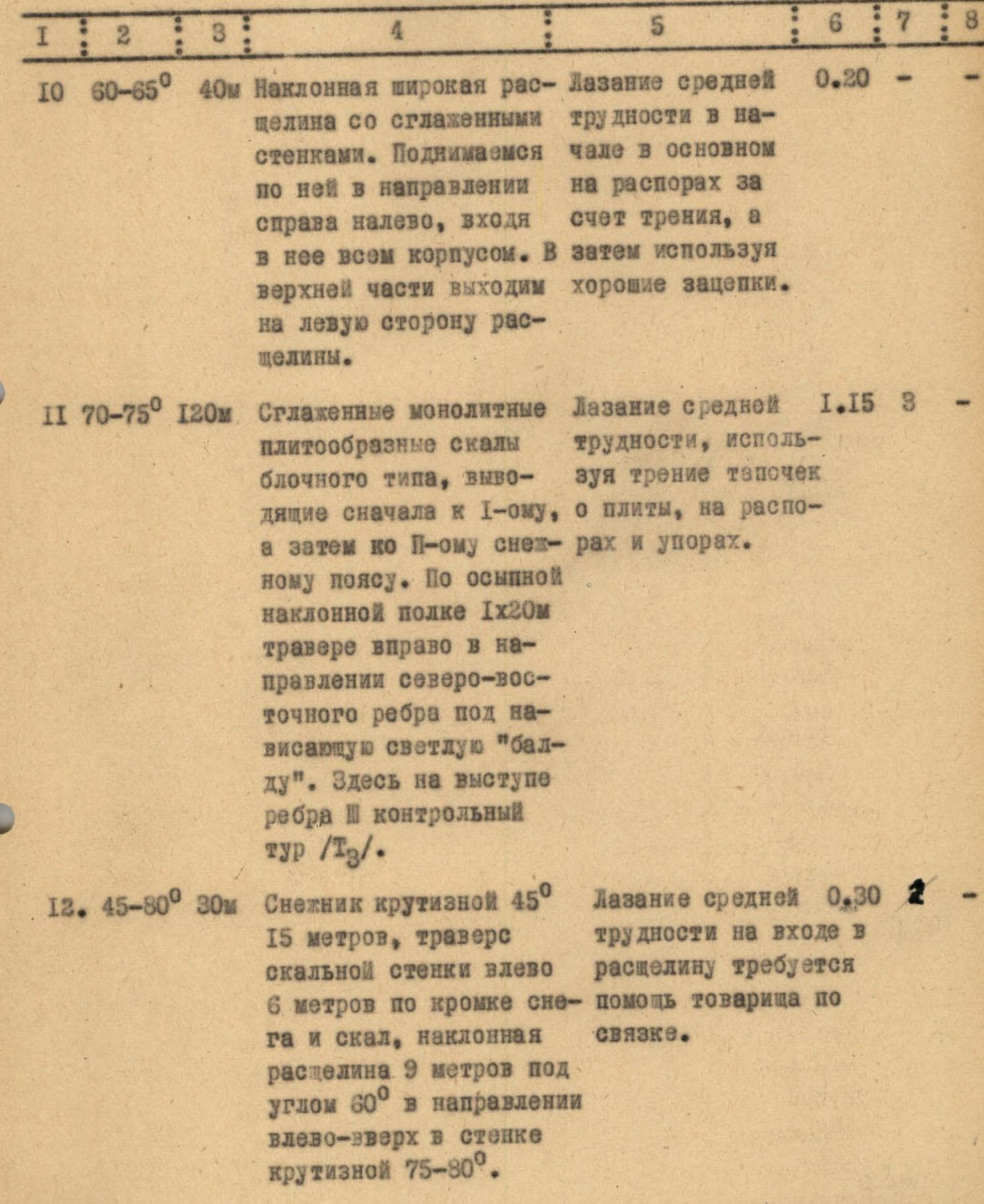
| 10 | 60–65° | 40 м | Inclined wide crack with smoothed walls. We ascend along it in the direction from right to left, entering it with our whole body. At the top, we exit onto the left side of the crack. Climbing is of medium difficulty, initially mainly on jams due to friction, and then using good holds. | 0:20 | – | – | – | – |
| 11 | 70–75° | 120 м | Smoothed monolithic slab-like rocks of block type, leading first to the 1st, and then to the 2nd snow belt. Along an osypnaya inclined shelf 1×20 m, traverse to the right in the direction of the North-East ridge under an overhanging light “bald head”. Here, on the ledge of the ridge, is the 3rd control cairn (R3). Climbing is of medium difficulty, using friction of gym shoes on the slabs, on jams and supports. | 1:15 | 3 | – | 3 | – |
| 12 | 45–80° | 30 м | Snowfield with a steepness of 45°, 15 m, traverse of a rock wall to the left 6 m along the edge of snow and rocks, inclined crack 9 m at an angle of 60° in the direction from left to right and upwards in the wall with a steepness of 75–80°. Climbing is of medium difficulty. At the entrance to the crack, assistance from a partner is required. | 0:30 | 2 | – | 2 | – |
| 13 | 75–80° | 40 м | Inner corner with rough walls without protrusions for holds and footholds. Difficult climbing mainly due to friction, using jams. | 0:55 | 4 | – | 4 | – |
| 14 | 80–85° | 30 м | Vertical crack in a smooth sheer wall with a steepness of 80–90°, 15 m. The edges of the crack are rough but without protrusions. The crack leads to a smoothed wall with a steepness of 80–75°. At the end of the section, there is a ledge for feet, washed away by water from the left. You can stand on it, holding onto a piton. Very difficult climbing along a narrow crack without a backpack, using hands for support. The body does not fit into the crack. Along the wall, complex climbing with a pull-up on a rope and using ladders. Backpacks are pulled up separately. | 1:35 | 5 | – | 5 | – |
| 15 | 80–85° | 50 м | Sheer rocks like slabs. To the right, there is an overhanging wall of a light “bald head”. Water flows down the rocks. Holds are smoothed, few, and only for the front phalanges of fingers. There are very few cracks, and they are shallow and narrow. At the end of the section, there is an osypnaya shelf where the 4th control cairn (R4) is built. Very difficult climbing using the entire arsenal of rock climbing techniques: ladders, pitons, pull-up on a rope. This is one of the key sections of the entire route. Backpacks are pulled up separately. | 3:00 | 5 | – | 5 | 3 |
| July 20 | | | | | | | | |
| 16 | 45° | 50 м | Easy rocks with a steepness of 60°, 10 m, leading to a snow-ice belt. Ascent upwards along the snow-ice slope in the direction of the slope, along steps dug out the previous evening. | 0:15 | – | – | – | – |
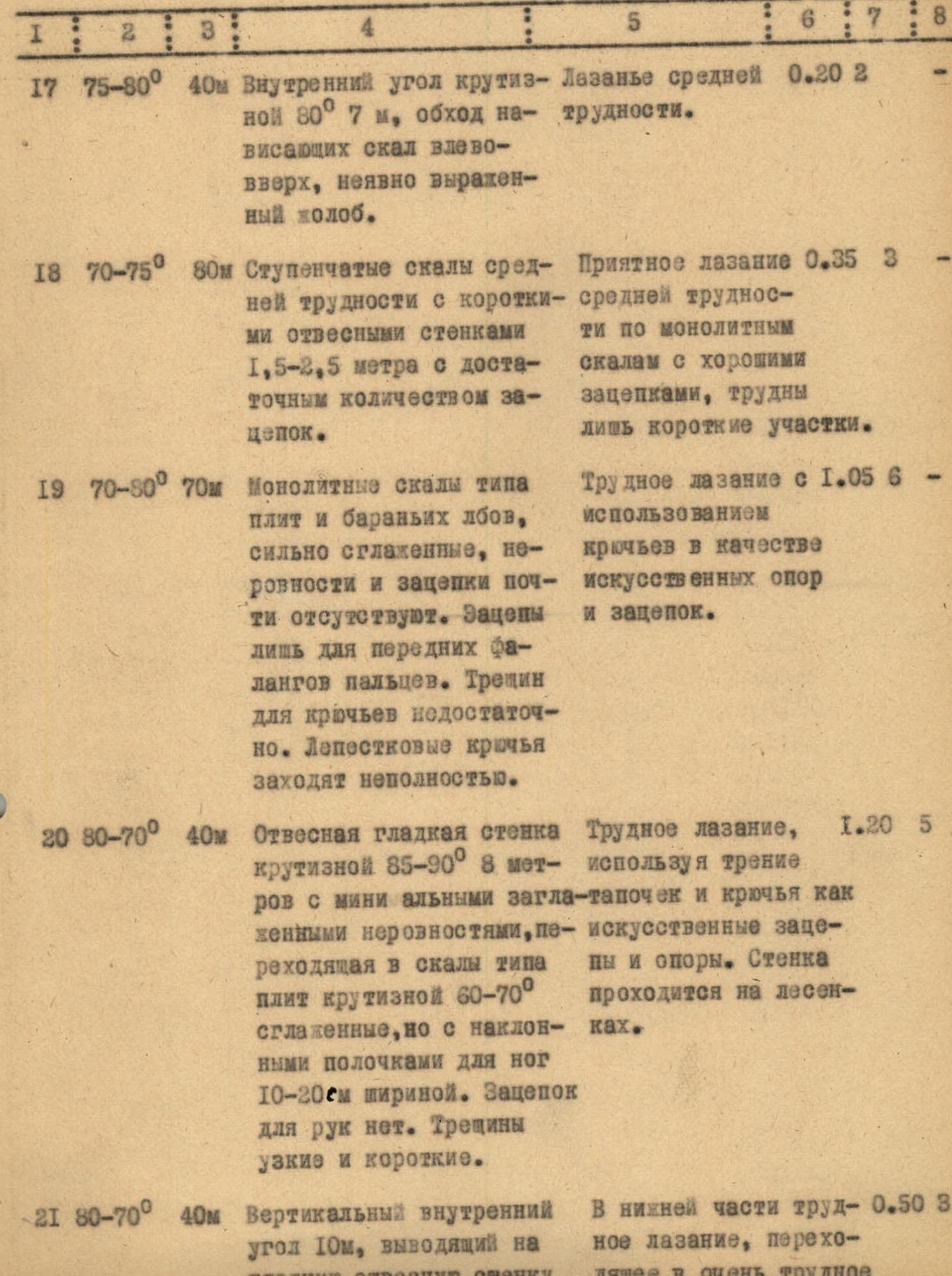
| 17 | 75–80° | 40 м | Inner corner with a steepness of 80°, 7 m, bypassing overhanging rocks to the left and upwards, not clearly expressed colob. Climbing is of medium difficulty. | 0:20 | 2 | – | 2 | – |
| 18 | 70–75° | 80 м | Stepped rocks of medium difficulty with short sheer walls 1.5–2.5 m with a sufficient number of holds. Pleasant climbing of medium difficulty on monolithic rocks with good holds, difficult only on short sections. | 0:35 | 3 | – | 3 | – |
| 19 | 70–80° | 70 м | Monolithic rocks like slabs and “ram's foreheads”, strongly smoothed, with almost no irregularities or holds. Holds are only for the front phalanges of fingers. There are not enough cracks for pitons. Petal pitons do not fit fully. Difficult climbing using pitons as artificial supports and holds. | 1:05 | 6 | – | 6 | – |
| 20 | 80–70° | 40 м | Sheer smooth wall with a steepness of 85–90°, 8 m, with minimal smoothed irregularities, turning into rocks like slabs with a steepness of 60–70°, smoothed but with inclined ledges for feet 10–20 cm wide. There are no handholds. Cracks are narrow and short. Difficult climbing using friction of gym shoes and pitons as artificial holds and supports. The wall is passed on ladders. | 1:20 | 5 | – | 5 | – |
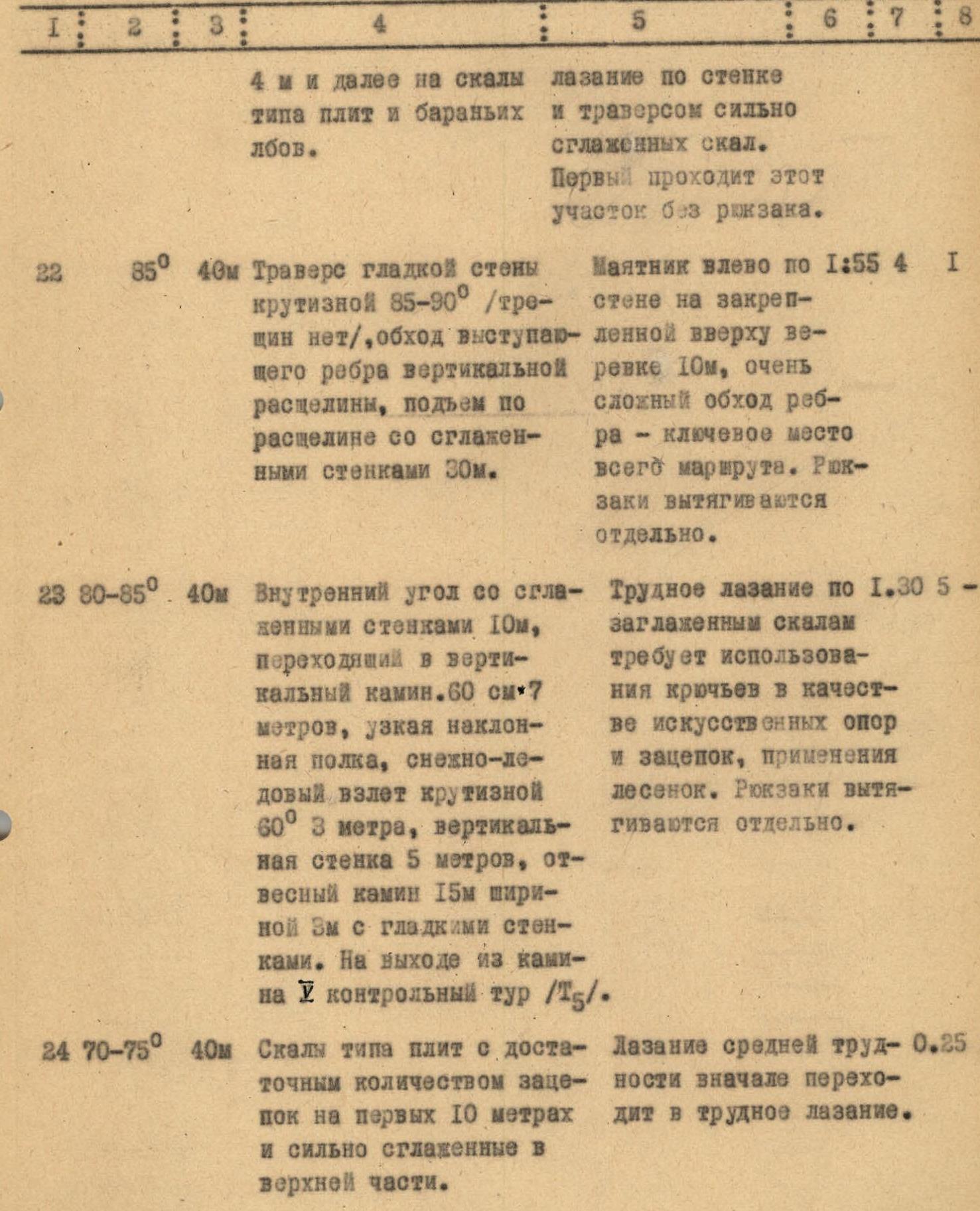
| 21 | 80–70° | 40 м | Vertical inner corner 10 m, leading to a smooth sheer wall 4 m, and further to rocks like slabs and “ram's foreheads”. In the lower part, difficult climbing turns into very difficult climbing along the wall and traverse of strongly smoothed rocks. The first climber passes this section without a backpack. | 0:50 | 3 | – | 2 | – |
| 22 | 85° | 40 м | Traverse of a smooth wall with a steepness of 85–90° (there are no cracks), bypassing the protruding edge of a vertical crack, ascent along the crack with smoothed walls 30 m. Pendulum movement to the left along the wall on a rope fixed above 10 m, very complex bypass of the edge — a key point of the entire route. Backpacks are pulled up separately. | 1:55 | 4 | – | 4 | 1 |
| 23 | 80–85° | 40 м | Inner corner with smoothed walls 10 m, turning into a vertical chimney. 60 cm × 7 m, narrow inclined ledge, snow-ice ledge with a steepness of 60°, 3 m, vertical wall 5 m, sheer chimney 15 m wide 3 m with smooth walls. At the exit from the chimney, the 5th control cairn (R5). Difficult climbing along smoothed rocks requires the use of pitons as artificial supports and holds, and the use of ladders. Backpacks are pulled up separately. | 1:30 | 5 | – | 5 | – |
| 24 | 70–75° | 40 м | Rocks like slabs with a sufficient number of holds on the first 10 m and strongly smoothed in the upper part. Climbing is of medium difficulty at first, turning into difficult climbing. | 0:25 | 2 | – | 2 | – |
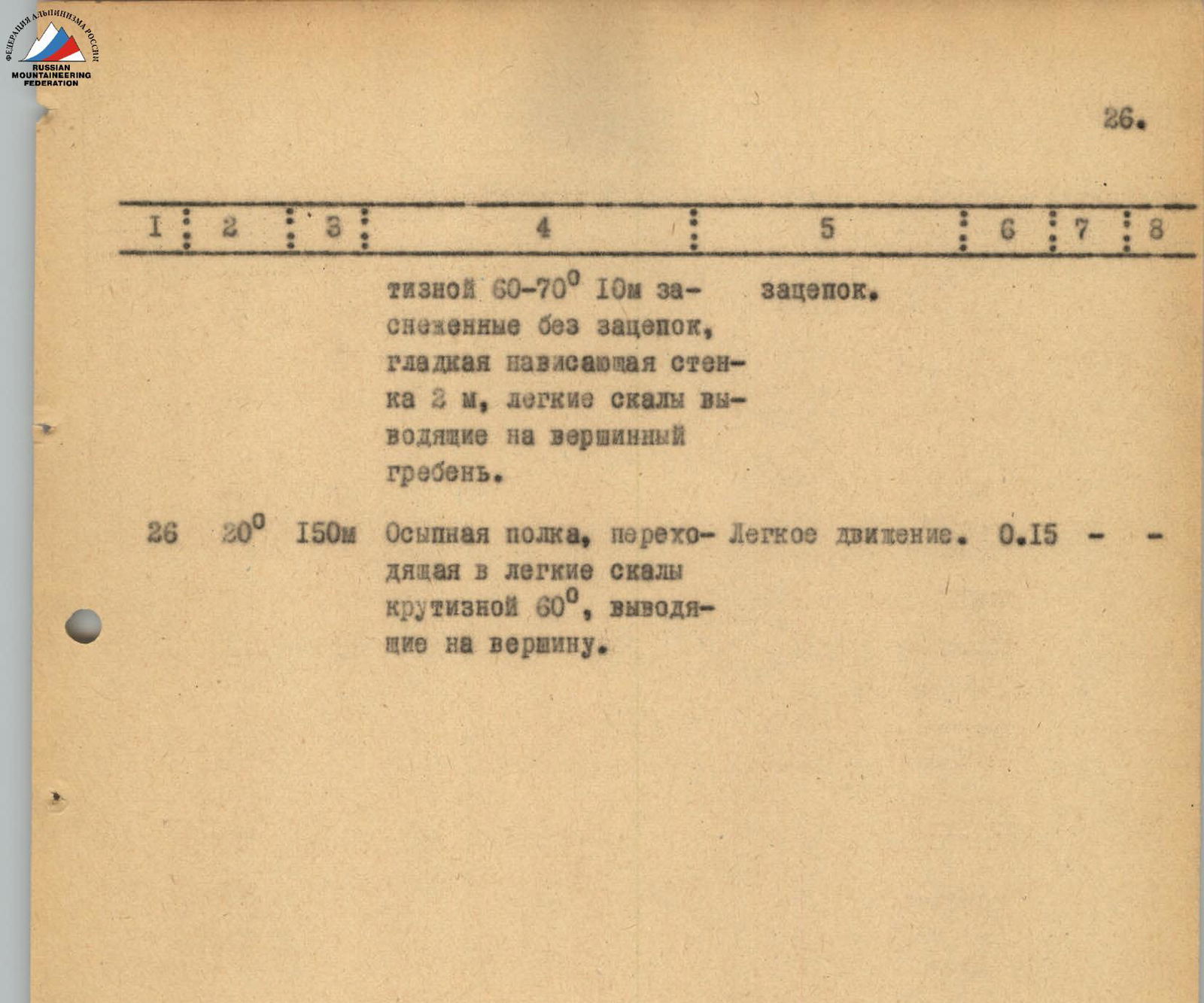
| 25 | 60–70° | 40 м | Snow-ice ridge with a steepness of 50°, 10 m, slabs of an inner corner with a steepness of 60–70°, 10 m, snow-covered without holds, smooth overhanging wall 2 m, easy rocks leading to the summit ridge. Difficult climbing due to the snow-covered rocks and lack of holds. | 0:50 | 3 | – | 3 | – |
| 26 | 20° | 150 м | Ospyannaya shelf turning into easy rocks with a steepness of 60°, leading to the summit. Easy movement. | 0:15 | – | – | – | – |

General conclusion on the route
Having familiarized ourselves with the description of the ascent route and the photographs, we can assess its logic, originality, and complexity.
The height difference of the route is 1000 m, including the most complex sections — 410 m. The average steepness is 60–65°, and the steepness of the most complex sections is 80–85°.
Almost along the entire length, the route passes along steep sheer rocks and includes complex free climbing, organically combined with the need to apply techniques of movement using artificial support points on the most difficult sheer and smoothed sections.
The route is rocky, but it includes the passage of steep snow-ice slopes up to 40 m in length and snow-covered rocks.
A significant part of the route is composed of smoothed monolithic slab-like rocks of block type, which calls into question the possibility and rationality of using conventional footwear with crampons and forces the use of rubber footwear.
The steepness and smoothness of the rocks on a considerable number of sections do not allow climbing with backpacks. They have to be pulled up separately.
The route requires specially selected equipment, excellent mastery of modern rock climbing techniques, good physical and moral preparation, as well as sufficient experience in climbing wall routes.
The group passed the route in 3 days, spending 30 hours of walking time and driving about 90 pitons, including 6 pitons.
Comparing the passed route with serious wall routes of the highest category of difficulty climbed by individual participants of the group (see the table), we can conclude that the route up the North-East wall of the Dalar peak belongs to the most difficult wall routes of category 5B.
Comments
Sign in to leave a comment