Brief Characteristics of Dalar Peak
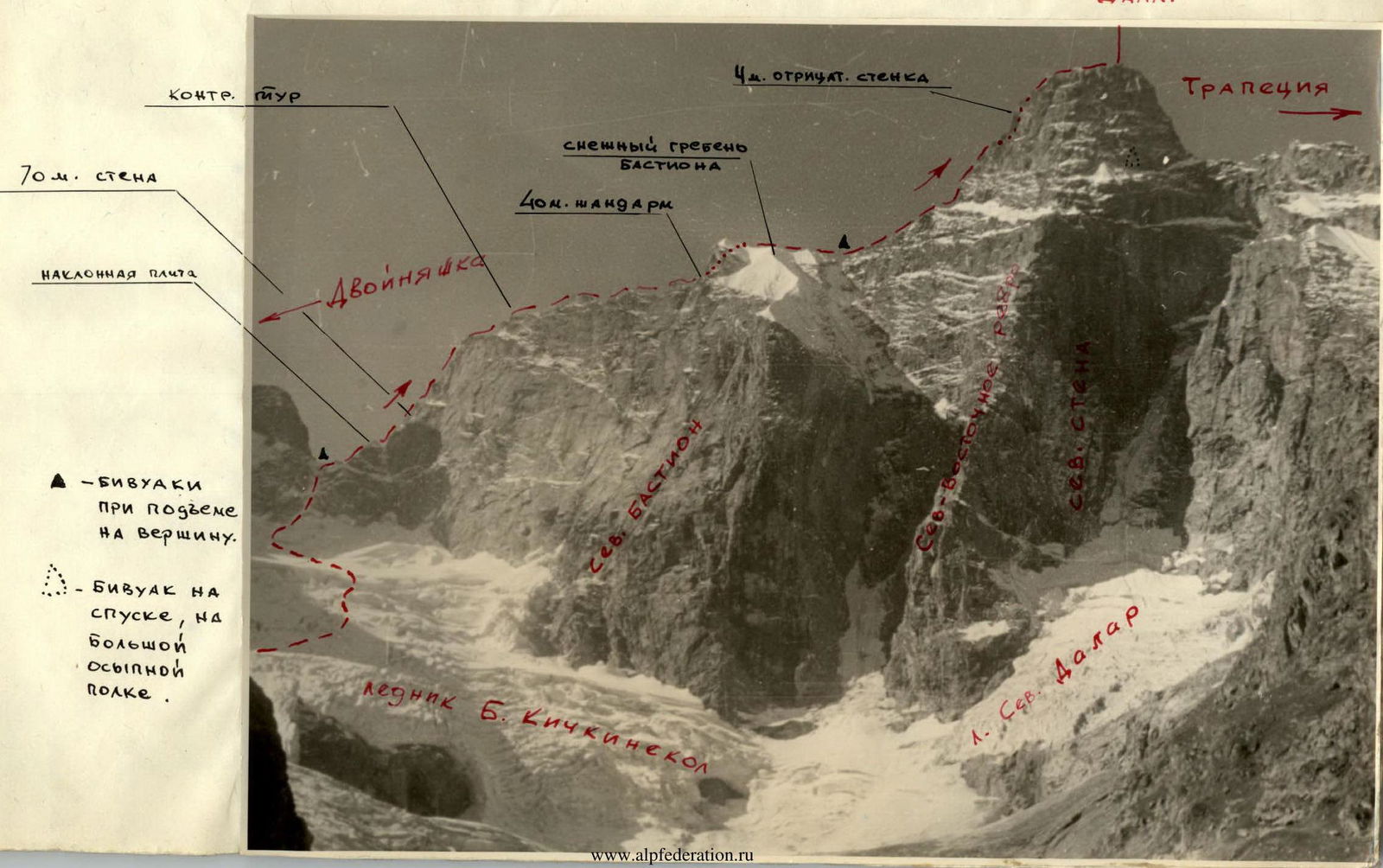
Dalar Peak (elevation 3981 m above sea level) is located in the western part of the Central Uplift of the Main Ridge. It is 25 km west-southwest of Elbrus.
The chain of peaks (Filter, Zamok, Dvoinyashka, Dalar, and Shokoladny) bounds the cirque of the Bolshoy Kichkinokol glacier from the south, east, and west, giving rise to the eponymous river, which flows into the Uzunkol River.
The first ascent to Dalar Peak was made in 1937 via route 3B cat. sl. After 1960, other routes were climbed and classified on Dalar:
- 5B on the North Face;
- 5B on the NE ridge;
- 4B from Shokoladny Peak;
- 4A from the south.
The ridge from the east remained, which was traversed in the reverse direction (on descent) by a group from CSKA in 1962 during the traverse of the Kichkinokol horseshoe. The route along the Eastern ridge is very logical.
Sports Group Composition
The team from the Moscow City Council of the DSO "Spartak" embarked on the route in the following composition:
- Kavunenko V.D. — MS, leader
- Abalakov O.V. — MS
- Utkín B.M. — MS
- Shataev V.N. — 1st sports rank
- Balashov A.M. — 1st sports rank
This was the final training ascent before the route to the championship of the USSR, and to test the snow in the upper part of the bastion.
Reconnaissance, Equipment
The first acquaintance with Dalar Peak took place on June 15, 1964, during a reconnaissance sortie. It was then decided to attempt the first ascent of the Eastern ridge from the Bolshoy Kichkinokol glacier, which is quite heavily crevassed.
The group had a "Nedra" radio station and took additional supplies for a cache on the bastion.
The group's equipment was of high quality — titanium rock and ice screws, pitons, and piton hooks, etc.
ASCENT
July 13 — 16:00 — departure at the scheduled time. The scorching sun's rays accompanied us for a short time; within 20 minutes, we were walking along a trail in the forest. And 30 minutes later, Dalar appeared in all its glory — refreshed and whitened by snow. It had rained in the camp for the past 5 days. Everyone examined the labyrinth of crevasses on the Bolshoy Kichkinokol glacier through binoculars.
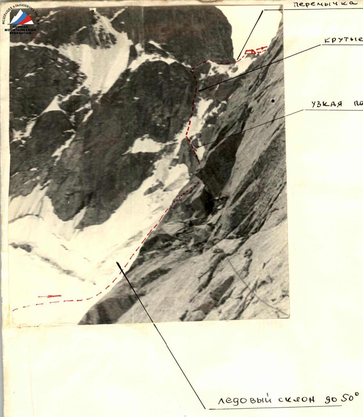
July 14 — 4:00. We were helped by the fresh snow, and we traversed without crampons under the slopes of Zamok, and within 3 hours, we gained height towards the saddle. The first meters were challenging — smooth rocks dusted with snow. The exposed ice at 45–50° did not allow a direct ascent, and progress along the rocks on the left was very difficult. Difficult climbing with piton protection along an internal corner, followed by 10 m along a very narrow ledge. Pressed against the wall, Oleg Abalakov won every centimeter.
July 14 — 15:00 we reached the saddle, where we found an excellent platform under a gendarme, made by the CSKA group in 1962. 9 hours of work to reach the saddle! This was the most challenging section of the entire route. It is not safe to pass during the second half of the day — rocks and icicles.
July 15 — While the group set up the bivouac, Kavunenko and Abalakov proceeded on the route. A wide 70-meter slab barred the way. The first meters were challenging, the rocks were smooth, and there were almost no holds. Then the slab became more broken, and movement was only possible with alternate protection. Descent into a small depression and a 45-meter wall lay ahead. A possible route was visible to the left, 30 m up a crack, but a direct ascent was the most rational. Difficult climbing, with the first climber ascending without a backpack. It was beneficial that one of the group members had Vibram soles — this significantly eased the passage of such challenging sections. The weather was in our favor — not a single cloud, and we derived immense pleasure.
We reached a control cairn on the ridge and found a note from K. Rototaev. Yes, it was challenging for him on the descent along the wall and slab.
A red double gendarme — the first half was traversed on the right along a ledge and crack, and the second half along a rocky snow-covered ledge with an exit up a crack onto the ridge. The exit was very difficult climbing without a backpack. The path became easier thereafter. Only a small gendarme had to be bypassed on a ledge between an overhanging section and snow. After traversing 40 m (of the black large gendarme) with challenging climbing, we reached a tooth and looped a rope around it for the descent. 30 m of rappelling to the snow, with a slight pendulum movement to the right. The snow on the ridge of the bastion held well. By 16:00, we were at a rocky rise behind a depression. The site for the night was excellent. Clouds rose from below, and unexpectedly, we heard a dog barking here (!). Both the weather and the pace of our progress were in our favor.
July 16 — A straightforward ridge led to the summit tower, which we decided to bypass on the left along a ledge. Progress was significantly hindered by snow at 50°. Then, along rocks of medium difficulty, we reached under a slab on the ridge. We decided not to touch it but left a cairn and exited via a neighboring couloir onto the ridge beyond the slab. Challenging rocks at the beginning were covered with ice, but the sun helped, and the ice quickly melted. For the first time, we used a piton — a sheer 4-meter section without cracks — here, ladders were necessary. Then, large blocky rocks with small holds led under an overhanging cornice. A difficult traverse, and we were on a familiar ledge leading to the summit ridge.
For the second time, we stood on the summit of Dalar in a year! The descent route was familiar, and by 17:00, we stopped for the night on a good ledge.
July 17 — Descent to the "Uzunkol" alpine camp.
CONCLUSION ON THE ROUTE
All participants had extensive climbing experience, with 7 to 15 routes of the highest category. The unanimous opinion of the group was:
- The route to Dalar Peak along the eastern ridge from the Kichkinokol glacier is category 5A.
Particularly challenging was the exit to the saddle between Dvoinyashka and Dalar, the traverse of the black gendarme, and the exit onto the ridge to the left of the large yellow slab.
On the route, 36 rock pitons and 2 piton hooks were used. The route was completed in 22 hours of climbing time.
Proposed Routes
The presented route on Dalar peak cat. sl. in the area should be ...
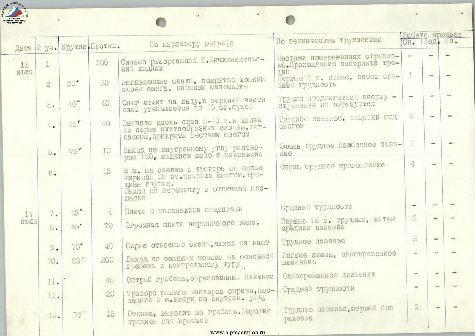
| Date | Sect. | Steepness | Length | Character of Relief | Technical Difficulties | Rk. | Ice | Pit. |
|---|---|---|---|---|---|---|---|---|
| July 13 | 1 | 500 m | Heavily crevassed Bolshoy Kichkinokol glacier | местами попеременная страховка. Прохождение лабиринта трещин | - | |||
| 2 | 50° | 30 m | Smooth rocks covered with a thin layer of snow, small holds | Первые 2 м отвес, затем средней трудности | 1 | - | ||
| 3 | 40° | 40 m | Snow lies on ice, the layer decreases to 20 cm dry in the upper part | Трудно продвигаться вверху — ступеньки не образуются | - | - | - | |
| 4 | 45° | 50 m | Initially along rocks 8–10 m and then along grey slab-like rocks, smoothed, partially covered with snow | Трудное лазанье, зацепки под снегом | 6 | - | ||
| 5 | 75° | 10 m | Exit along an internal corner with a 120° angle, few and small holds | Очень трудное свободное лазанье | 2 | - | ||
| 6 | 15 m | 5 м along rocks and traverse along a 25 cm wide ledge covered with snow, blind cracks. Exit to the saddle and an excellent platform | Очень трудное прохождение | 4 | - | |||
| July 14 | 7 | 45° | 4 m | Slab with small holds | Средней трудности | - | - | |
| 8 | 45° | 70 m | Huge tile-like slab | Первые 15 м трудные, затем среднее лазанье | 2 | - | ||
| 9 | 70° | 40 m | Grey sheer rocks, exit to the edge | Трудное лазанье | 3 | - | ||
| 10 | 25° | 200 m | Exit along talus ledges onto the main ridge to the control cairn | Лёгкие скалы, одновременное движение | - | - | ||
| 11 | 45 m | Sharp ridge formed by slabs | Одновременное движение | - | - | |||
| 12 | 20 m | Traverse of the red gendarme on the right, last 5 m up an internal corner | Средней трудности | - | - | |||
| 13 | 75° | 15 m | Wall leading to the ridge. Good cracks for pitons | Трудное лазанье, первый без рюкзака | 2 | - | ||
| 14 | 160 m | Passage along the ridge and bypass of a gendarme on the right along a small ledge, ending with 5 m of crawling between snow and rocks | Одновременное движение, в конце средней трудности | - | - | |||
| 15 | 20° | 40 m | Traverse to the right along small ledges, rocks smoothed, blind cracks. Direction towards black bands | Трудное свободное лазанье | 1 | - | ||
| 16 | 85° | 7 м | Along smoothed rocks to the right to a single protruding tooth | Очень трудный траверс | 1 | 1 | - | |
| 17 | 30 м | Rappelling to the snow in the direction of a "funnel" | Со стенки сыплет льдинками | - | - | |||
| 18 | 45° | 80 м | Snow slope — firm snow | Переменная страховка — ледоруб | - | - | ||
| 19 | 80 м | Snow ridge | Одновременное движение | - | - | |||
| 20 | 20° | 45 м | Sport climbing descent into a depression and exit along talus ledges to a good bivouac site on a rocky shoulder | Средней трудности | - | - | ||
| 21 | 60 м | Ridge leading to the summit tower | Средней трудности | - | - | |||
| 22 | 60 м | Left along a ledge, partially snowy — 50° | то же | 1 | - | |||
| 23 | 45° | 120 м | Right-upwards, rocks like "ram's foreheads" towards a yellow slab | то же | 2 | - | ||
| 24 | 20 м | Not reaching the slab 40 m, traverse left into a couloir | то же | - | - | |||
| 25 | 60° | 15 м | Rocks with a small number of holds | Трудное лазанье | 1 | - | ||
| 26 | 85° | 2 м | Internal corner, covered with a thin layer | то же, лесенка | 1 | 2 | ||
| 27 | 85° | 4 м | Smooth slab without cracks | то же | - | - | ||
| 28 | 75° | 23 м | Slab-like rocks with small holds | Сложное лазанье | 3 | - | ||
| 29 | 70° | 6 м | Slab under overhanging rocks | Трудное свободное лазанье | 1 | - | ||
| 30 | 20° | 30 м | Exit along a barely noticeable ledge onto a buttress | Средней трудности | 1 | - | ||
| 31 | 70° | 40 м | Stepped large-block rocks with a small number of holds. Movement towards the pre-summit ridge | то же | 2 | - | ||
| 32 | 2 м | Traverse left under an overhanging cornice. Exit onto a talus ledge | Трудное лазанье | 1 | - | |||
| 33 | 15° | 40 м | Talus ledge leading to the ridge | Лёгкой трудности | - | - | ||
| 34 | 40 м | Simple ridge — exit to the summit | Простое лазанье | - | - |