
ASCENT REPORT OF KCHR TEAM TO THE SUMMIT OF BOLSHAYA KHATIPARA 3250 m
Via the eastern ridge. Category 1B. Restoring justice — returning the forgotten route to the classifier.
Tkachenko V. I. — 1st sports category Semenov M. A. — Candidate for Master of Sports
Report compiled in November 2019.
2. Caucasus
2.2 From Marukh Pass to Nakhar Pass
ASCENT PARTICIPANTS
- Leader — Vlad I. Tkachenko, 1st sports category. Coach — V. A. Shipilov. Participants: Mikhail A. Semenov, Candidate for Master of Sports. Coach — V. A. Shipilov. Address: 144001, Elektrostal, Oktyabrskaya St., 8, apt. 117. Phone: +7 (906) 724–94–53. Email: aravigehc@mail.ru
ASCENT PASSPORT
-
Western Caucasus, Dombay region, section 2.2 of the route classifier for mountain peaks.
-
Bolshaya Khatipara 3250 m. Via the eastern ridge.
-
Category 1B ascent.
-
Route type: Rocky.
-
Height difference: 800 m. Route length: 1150 m. Length of sections with category 1 difficulty: 1000 m. Length of sections with category 2 difficulty: 150 m.
Average slope: 40°.
-
Number of pitons left on the route: 0.
-
Team's walking hours: 5 hours, 1 day.
-
Descent from the summit via the ascent route.
-
Leader: Vlad I. Tkachenko, 1st sports category, coach V. A. Shipilov.
-
Departure onto the route: 07:30, July 27, 2015. Summit reached: 12:30, July 27, 2015.
-
Alpclub "Gornoye Bezumiye" (Mountain Madness).
-
Responsible for the report: M. A. Semenov, aravigehc@mail.ru.
DESCRIPTION OF THE ASCENT AREA
Toponymy (decoding, translation of the name):
Bolshaya Khatipara — a river in the Karachay-Cherkess Republic, a left tributary of the Teberda River, originates on the southeastern slopes of Mt. Bolshaya Khatipara (3250 m). Various opinions are expressed about the etymology of this name.
According to S. Ya. Bayiorov, Khatipara is a Proto-Bulgar toponym-hydronym meaning "river of ridges".
However, S. Kh. Ionova argues that additional arguments can be made in favor of the Abazin and Abkhazian origin of this toponym. Firstly, the toponym Khatipara can be broken down into the following Abkhaz-Abazin elements: Khat — an anthroponym, y — a possessive affix "his", para (parta) — "place of jump". The lexeme as a whole means "Khat's jumping place". Secondly, the toponym "fits" into the Abazin realities. The well-known Caucasologist L. I. Lavrov claimed that the Abazins had long settled in Teberda, and Abazin-Loovtsy remained there until the 1860s.
OUR ASCENT IS NOT A FIRST ASCENT!!!
B. N. Delone's book "Peaks of the Western Caucasus" is documentary evidence that the first official ascent to this mountain was recorded in 1925. Therefore, I see no reason to emulate various adversaries like A. Donskoy (who discredits Teberdinians) by attributing someone else's ascents to ourselves and claiming them as first ascents. In my opinion, it is possible that people climbed Khatipara even before 1925, as I see no reason why they couldn't have done so earlier.
The situation is as follows: The GSK "Arkhyz" plans to hold a gathering in this area with a base camp near Azgek. There are enough peaks for fulfilling the norms of the third sports category; what's missing is a mountain with a category 1B ascent. But there's no need to invent anything. The ascent to Bolshaya Khatipara was long ago climbed, classified, and described. Below is the description with an excerpt from B. Delone's book.
BOLSHAYA KHATIPARA, approx. 3250 m, category 1A
The ascent to Bolshaya Khatipara initially follows a good path along the valley of the Bolshaya Khatipara River, just like when ascending Malaya Khatipara. From the upper pastures, they turn left up the meadows towards a small pass under the main tower of Bolshaya Khatipara, north of it, through the ridge connecting it to Malaya Khatipara. It takes about 5 hours of walking to get here.
Through this pass and further, skirting the base of the main tower from the west and gradually ascending, they reach a couloir descending from the ridge of Bolshaya Khatipara to the Azgek firn from a saddle located on this ridge to the west of the main tower (the main tower is somewhat protruding north of the ridge).
Half an hour of easy rock climbing up the couloir leads to the aforementioned saddle. From here, a beautiful view of the Main Ridge suddenly opens up. From the saddle, more difficult rock climbing leads to the main tower (20 minutes).
The entire ascent takes about 6 hours.
It is also possible to descend to the pastures by skirting the main tower from the south under the very summit along easy rocks, and then along the scree of the northern slope-ridge running east from the main summit (in 3 hours).
This ascent outside the Main Ridge may be the most interesting of the not-too-difficult ascents. From Bolshaya Khatipara, a remarkable view of the Main Ridge opens up (the view from Malaya Khatipara is partially obscured by Bolshaya Khatipara). The first ascent was made in 1925.
Route from the north, category 1B
From the pasture (see "Bolshaya Khatipara"), the summit of Bolshaya Khatipara is clearly visible. Under its northern slope, there is a semblance of a pass. If you ascend to it, you can see that it is the entrance to a cirque, above which the summit of Bolshaya Khatipara stands on the southwest side. Entering the cirque and skirting the northern edge of Bolshaya Khatipara along the scree, they approach the northern rocks of the main tower of Bolshaya Khatipara. A short ascent up the wall leads to a ledge rising to the left upwards. Along this, and then along another ledge to the right upwards, they reach a small couloir, along which they climb to the very summit.
DESCRIPTION OF THE APPROACH
We began our ascent from the enclosures in the Teberda Reserve. We ascended via the trail through a semi-destroyed hut to the summit of Malaya Khatipara and descended from it to the "Milyy" pass. From the "Milyy" pass, a wonderful view of the summit of Bolshaya Khatipara and the lake below it opened up. From the "Milyy" pass, we descended to the lake, skirted its cirque in the direction of the eastern ridge of Bolshaya Khatipara, and along несложным скалам and scree exited onto the ridge, and along a несложному гребnyu, местами достигающего сложности 2А, ascended to the summit of Bolshaya Khatipara.
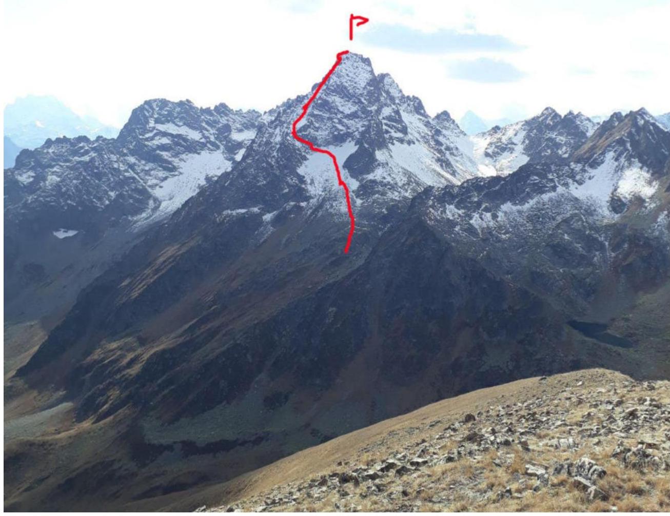
Bolshaya Khatipara 3250
Bolshaya Khatipara 3250
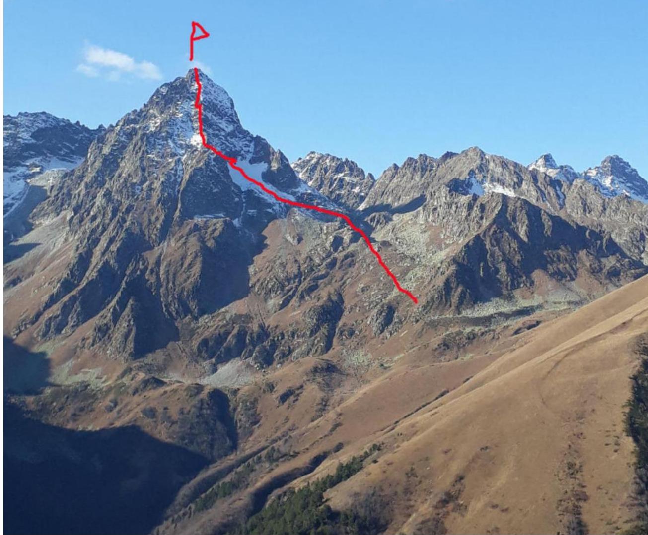

Photo taken from the
For routes with categories 1B–3B.
| Section # | Length | Slope | Terrain characteristics | Difficulty category | Number of pitons |
|---|---|---|---|---|---|
| 1150 m | 40° | Rocky | 1Б | 0 |
Words of gratitude for help in compiling the report:
Vyacheslav A. Shipilov Roman Yu. Gubanov Ekaterina A. Kuznetsova Vlad I. Tkachenko
And to everyone who didn't interfere :)))))
Ascent leader: V. I. Tkachenko.
Participants: M. A. Semenov.
Coaches: V. A. Shipilov.
Comments
Sign in to leave a comment