
Report
On the ascent of the combined team of KCHR to the summit of Pik Ine 3455 m
via the southeastern counterfort. Presumably 4B category of complexity. First ascent.
Semyonov M. A. — team leader Ankudinov A. I. — Candidate for Master of Sports
Date of report compilation: November 2019
2. Caucasus
2.2 From Marukh Pass to Nakhar Pass
Participants of the ascent
- Team leader — Semyonov Mikhail Alexandrovich. Candidate for Master of Sports. Coach — Shipilov V. A. Address: 144001, Elektroсталь, Oktyabrskaya st., 8, apt. 117. Phone: +7 (906) 724–94–53. Email: aravigehc@mail.ru
- Ankudinov Alexey Ivanovich, 3rd sports category, Yessentuki. Coach — Motienko N. I.
Ascent Passport
- Western Caucasus, Dombay region, section 2.2 of the route classifier for mountain peaks.
- Pik Ine 3455 m. Via the southeastern counterfort.
- Proposed category: 4B. First ascent.
- Rock climbing route.
- Height difference: 455 m.
Route length: 650 m.
Length of sections by complexity category:
- III category: 210 m
- IV category: 400 m
- V category: 20 m
- VI category: 20 m (ITO A2 e) Average steepness: 60–65 degrees.
- Number of pitons left on the route: 0
- Team's total climbing hours: 26 hours, 3 days.
- Descent from the summit via route 2A, from the north to the east.
- Team leader: Semyonov Mikhail Alexandrovich, Candidate for Master of Sports, coach Shipilov V. A. Participant: Ankudinov Alexey Ivanovich, 3rd sports category, coach Motienko N. I.
- Start of the route: 15:00, September 17, 2018. Summit: 00:30, September 19, 2018.
- Alpclub "ARKHYZ", alpclub "FREELINE"
- Responsible for the report: Semyonov M. A., aravigehc@mail.ru
Description of the Climbing Area
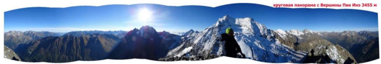
Pik Ine 3455 m is located on a spur from the Main Caucasus Range in the Dombay-Ulgen valley. The path to the summit begins from Dombayskaya Polyana, through the Dombay-Ulgen valley, just before the fork to Chuchkhur waterfalls and the trail to the Ptysh valley; it's possible to drive to this point in a 4WD vehicle. On foot, it takes about 1.5 hours. Cross the river at its widest point and continue along the grassy slopes past a waterfall between Pik Zoloto and Pik Ine; the waterfall is passed on the right, and then continue up the grassy slopes and moraine to the base of the glacier under Pik Ine, almost to the start of the 4B route, at the classic camping spots used for 2A ascents on Pik Ine from the north. From Dombayskaya Polyana, it takes 4–5 hours.
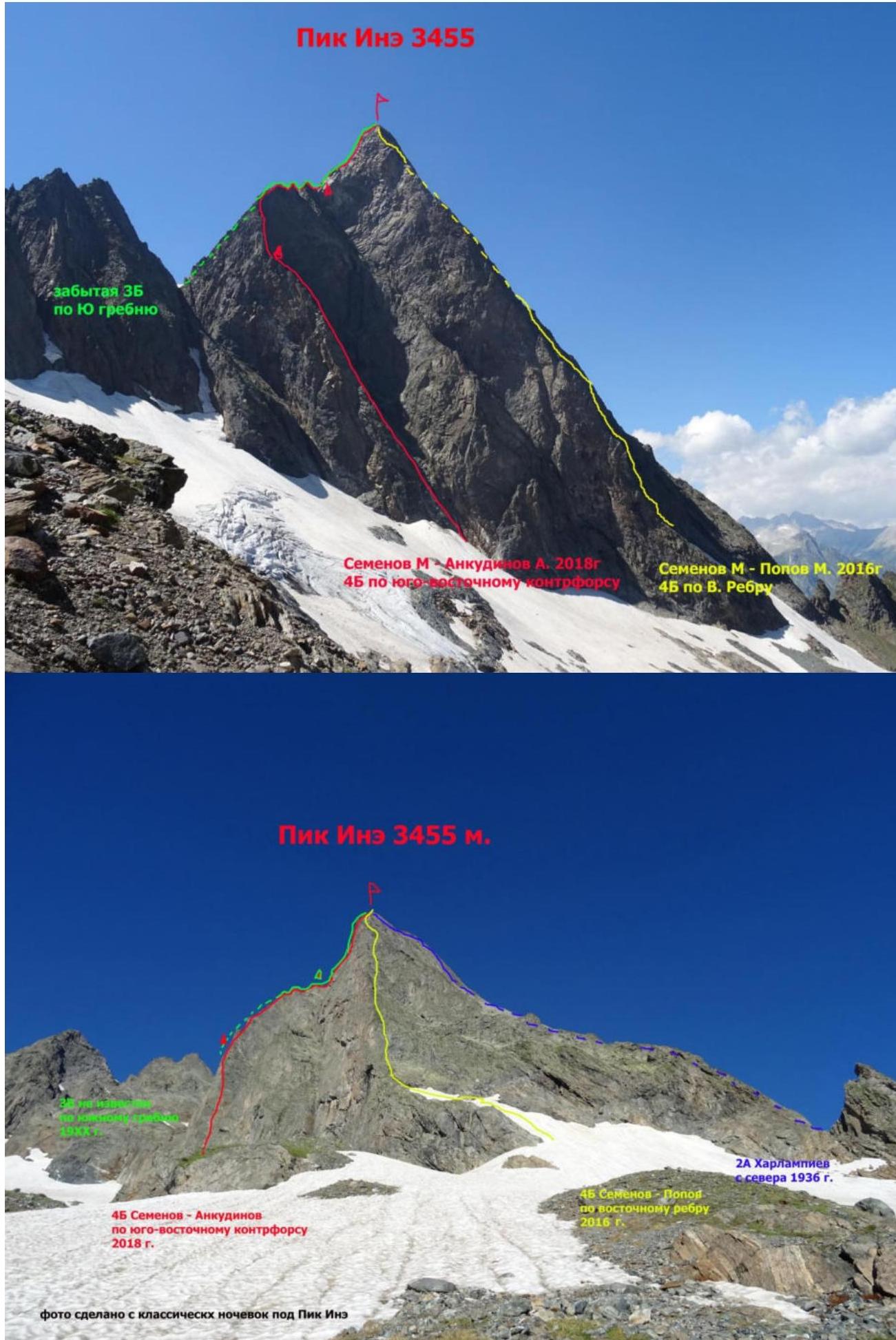 Photo taken from the classic camping spots under Pik Ine
 Photo taken from Ine Malaya or Pik Zoloto
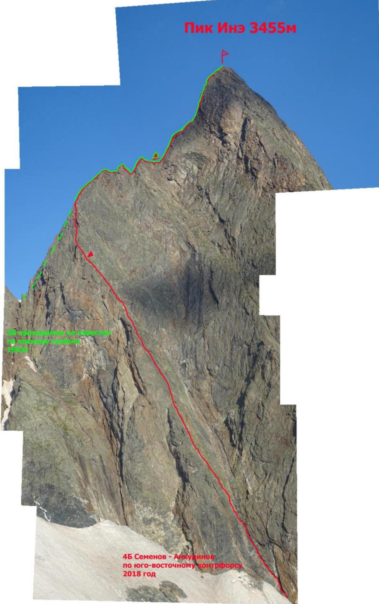
Route Diagram
| Section Number | Section Description | Length (m) | Steepness (°) | Complexity (UIAA) |
|---|---|---|---|---|
| R8–R9 | follows the S ridge (see 3B via S ridge) | 55 | 65 | III+ / IV- |
| R7–R8 | 50 | 75 | IV+ | |
| R6–R7 | 45 | 70 | IV+/- | |
| R5–R6 | 50 | 70 | III+ / IV- | |
| R4–R5 | 50 | 70 | IV- | |
| R3–R4 | 55 | 80–85 | V+ / IV- (A2 e 10 m) | |
| R2–R3 | 55 | 75 | IV- | |
| R1–R2 | 30 | 85–90 | VI (ITO A2) | |
| 20 | 50–60 | III+ / IV- | ||
| R0–R1 | 50 | 75–80 | IV+ |

Route Description by Sections
R0–R1 — The only logical start to the route is from a characteristic internal corner (or a very steep inclined ledge), where water flows even at the end of the season. Enter this internal corner from the glacier. Climb up predominantly through the left part, trying not to get wet. If you slightly exit the corner onto the left wall, there's a good, comfortable ledge for a belay station — the water doesn't reach there (at least, not in September). 50 m, 80°, IV+.
R1–R2 — From the station, return to the internal corner and, bypassing the overhangs on the left, use ITO on the left part of the wet corner. From the top of the corner, exit onto the "ram's foreheads" and continue to a comfortable ledge for a belay station. 30 m, 85–90°, VI (ITO A2), 20 m, 50–60°, III+.
R2–R3 — (The route generally follows the right edge of the southeastern counterfort, reaching the very edge of the ridge only at the top before exiting onto the southern ridge.) Climb up the internal corner to a comfortable station. 55 m, 75°, IV-.
R3–R4 — Continue up the system of internal corners to a wall with almost no relief; use ITO on anchors and two transitions on 5 mm skyhooks. Exit to the top of the wall — station. It seemed possible to deviate to the right to bypass this wall, but it wasn't appealing due to frequent rockfall on the right part of the southeastern counterfort. 55 m, 80–85°, V+ / IV- (ITO A2 e 10 m).
R4–R5 — Climb the wall (mainly consisting of "ram's foreheads," partially covered in snow) to a comfortable spot. 50 m, 70°, IV-.
R5–R6 — Continue upward to a wide ledge, where it's possible to bivouac; in the pseudo-description by Rybak, this spot was supposed to have a control point (CP) № 2, and they allegedly bivouacked here on descent. It's a spot easily observable with binoculars. With 99.9% certainty, we were the first humans here. A bit above this ledge — station. 50 m, 70°, III+ / IV-.
R6–R7 — Continue upward, parallel to the edge of the counterfort, nearly reaching its edge. At the point where the line clearly reaches the edge, there's an excellent spot for a CP. Since we were misled by the cheat Rybakov and thought we were at least on the second ascent, not the first, we didn't set up any CPs. I believe this spot is ideal for CP № 1 on this route. Climb a bit along the ridge that turns right. 45 m, 70°, IV+/-.
R7–R8 — Continue straight up the ridge wall — a delicate climb almost to the exit onto the counterfort ridge, turning right towards the southern ridge. 50 m, 75°, IV+.
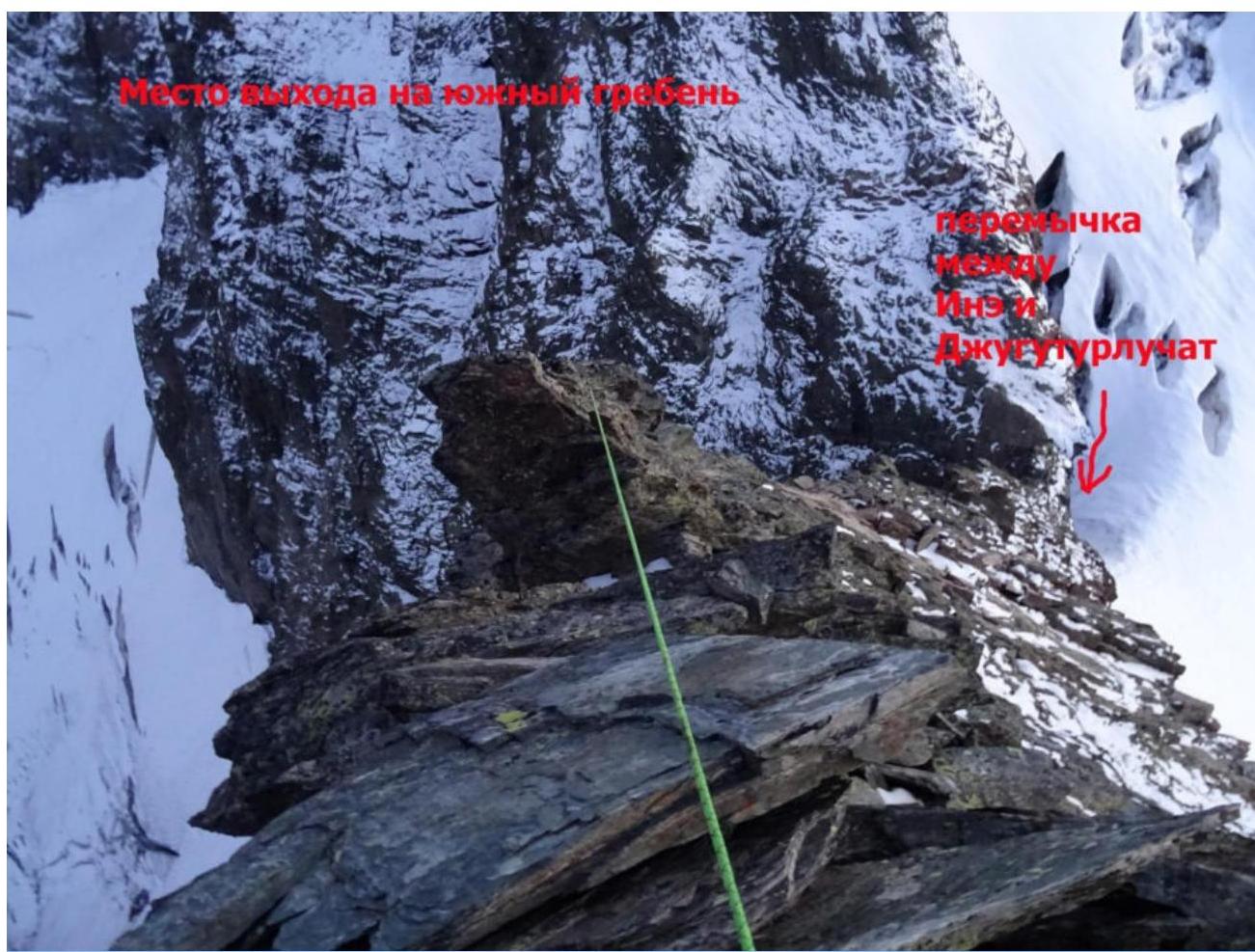
R8–R9 — Take the easiest path to the edge of the southeastern counterfort and follow it to the confluence with the southern ridge. 55 m, 65°, III+ / IV-.
R9–R12 — The route exits onto the southern ridge approximately 70 m from the start of 3B via the southern ridge and is identical to it thereafter. See the description of 3B on Pik Ine via the southern ridge.
The Origin of the Controversy
Why it's 99.9% certain that this is a first ascent!
Before this ascent, I had climbed this mountain via: 4A, first ascent of 4B via the eastern rib, and consequently, we descended via 2A. The mountain held no interest for me.
One autumn, Lyosha Ankudinov called me and suggested, "Let's climb Pik Ine via 2A?" I replied, "Not interesting," and proposed alternative lines that I hadn't climbed. There are only two lines on Ine: a forgotten 3B via the southern ridge and a 3B (recently added to the classifier, unknown to the Respected Senior Comrades, and to the not-so-respected ones either). The southeastern counterfort seemed more interesting to me — a beautiful line with a compelling name including the word "counterfort." It was submitted as 4A. However, the description on the FAR site was unimpressive, giving the impression it was written in a drunken haze. Nonetheless, the line is logical (incidentally, after our ascent, Yuri Koshelenko mentioned in conversation that he hadn't heard of the route but had been eyeing the counterfort, which he thought was at least 4B — if not more). The team that supposedly climbed it before us was large and fast; we were only two. I convinced Lyosha (omitting Koshelenko's words to avoid unnecessary panic) to attempt this route. I even reassured him that, given his experience (he had only done one 3B before), we would be cautious and take a sleeping bag — he later reminded me of this.
Lyosha arrived, and the next morning, my friend Tolik Edisherashvili dropped us off. At a familiar spot, we forded the river and reached the classic camping grounds under 2A on Pik Ine (now also under the two 4B routes). Recalling the wisdom of Senior Comrades that "a запас in the backside doesn't strain," I insisted we start seeking the route's beginning that same day. The description included only dark photos and vague verbal instructions. On Rybak's last photo, there was a clear discrepancy: a dotted line in blue pen marked the correct start, but another start was indicated to the right — on crumbly overhangs. We also discovered there were no significant obstacles (like large rocks) on the route to the southern ridge. We initially tried to follow the description, searching for bergschrunds, but eventually decided to attempt the wet internal corner — the only logical spot to climb onto the counterfort. I climbed the first rope, switched to ITO by the end of it, and we stopped for the night due to darkness.
The next morning, we started early, set up the rope, and I began ITOing up the wet corner; the water flow had decreased overnight, so I didn't get too wet. We didn't find any CPs; the distance was much greater than Rybak's description suggested. Rybak's report mentioned avoiding the right part due to rockfall, but our climb was sometimes quite tense — on one wall, we had to switch to ITO and even drill two holes for skyhooks. Rybak's team allegedly ran this section with simultaneous belay.
The facts clearly indicating that Rybak's report is fake:
- Very quick ascent time for a large team (5 people): 14 hours. Our two-person team took 26 hours (even discounting 3–4 hours spent searching for the start, it's still significantly more).
- The number of pitons used in the first two ropes far exceeded the 26 hooks mentioned in Rybak's report. Moreover, they likely didn't have anchor pitons, which were very effective here.
- No signs of human presence were found on this line until the southern ridge, despite not much time having passed since the pseudo-first ascent.
- The alleged exit point onto the southern ridge marked by Rybak is already on the southern ridge, and there are no significant obstacles, including overhanging rocks on the southeastern ridge.
- Rybak's described line turns right and exits under a rock formation on the southern ridge, but it actually follows sheer walls.
- The route exits onto 3B via the southern ridge about 70 m from its start. Thus, climbers will have to complete nearly the entire 3B via the southern ridge, known for being very technical and requiring careful climbing and belaying. Many have made the mistake of underestimating this 3B, attempting it with just a couple of pitons, hoping to "sail through" like on Belalakaya (3B) or Pik Alibeksky (3B).
- Another clear fact and mistake in Rybak's report proving it's a fabrication.
Rybak's report states they descended via the ascent route, as indicated by a single overnight stay on descent at the second CP on the first page. There's indeed a ledge suitable for a large team, observable with binoculars. But why? There's a well-known, frequently climbed 2A route that can be descended without a single rappel (as we did after the first ascent of the eastern rib 4B — no rappels were needed); it leads to the same camping spots, and can be done even at night. Rybak's team likely rushed up the southeastern counterfort, and the descent via 2A was a trivial matter for them.
Let's reason further: suppose, for some reason, Rybak's team were crazy enough to descend via the ascent route. There should have been numerous descent stations left, right? Not a single station was found — not even a trace of human presence on this line until it merges with the southern ridge. One could argue that maybe we climbed the wrong route. Those familiar with the mountain know it's quite small, with limited options, especially on such a distinct and logical line.
Given the above, I'm taking the liberty and responsibility to state that with 99.9% certainty, Rybak fabricated this route. I doubt anyone else has climbed that wet internal corner, which is done by traversing its left wall, as setting up the first CP logically above this corner (described by the cheats as a difficult wall requiring ladders and jams) would make sense. If they had climbed this route, there wouldn't be so many discrepancies and inaccuracies.
As we reached the southern ridge, it got dark. We then entertained Roma Gubanov, who was camping under the icefall on Maly Dombay with clients on one side, and Vlad Tkachenko on SofrudzhU with clients on the other, with two lights slowly and steadily moving along the southern ridge. Lyosha protested several times, "Let's bivouac now." With some deception — "we're almost there, just a bit more, and a bit more again" — Lyosha resigned himself, and we reached the summit at 00:30. We had a snack, as the scenario was expected. We brought a sleeping bag-blanket, 1 cushion, and a plastic poncho. After the ascent, I was exhausted, and my "lights went out" — they came back on in the morning, as they often do after such ascents. We descended via 2A and returned to Dombay the same day.
The route's line is very logical, interesting, and technical. At the time of writing, I had climbed all known lines on this mountain, including a first ascent on the eastern rib. Now, having completed this line, it makes two.
Comparing this line to others on the mountain, I can confidently say it's the most complex and technical. It's far more challenging than my 4B ascent via the eastern rib. While 4B via the eastern rib can be recommended as a first 4B, I would advise this route only for experienced climbers, despite rating it as 4B.
Respected Members of the Classification Commission, if this route is assigned a lower category, it will amuse the entire climbing community. If that happens, those who attempt the second ascent will have a good laugh.
Publications on risk.ru about this mountain:
- Pik Ine 4B (via the eastern rib) ↗
- Pik Ine 4B unfairly attributed to Bychkov, for fantasy ↗
- Steel cable on Pik Ine — now not a myth ↗
- Another crossing on Pik Ine (approach to 2A) ↗
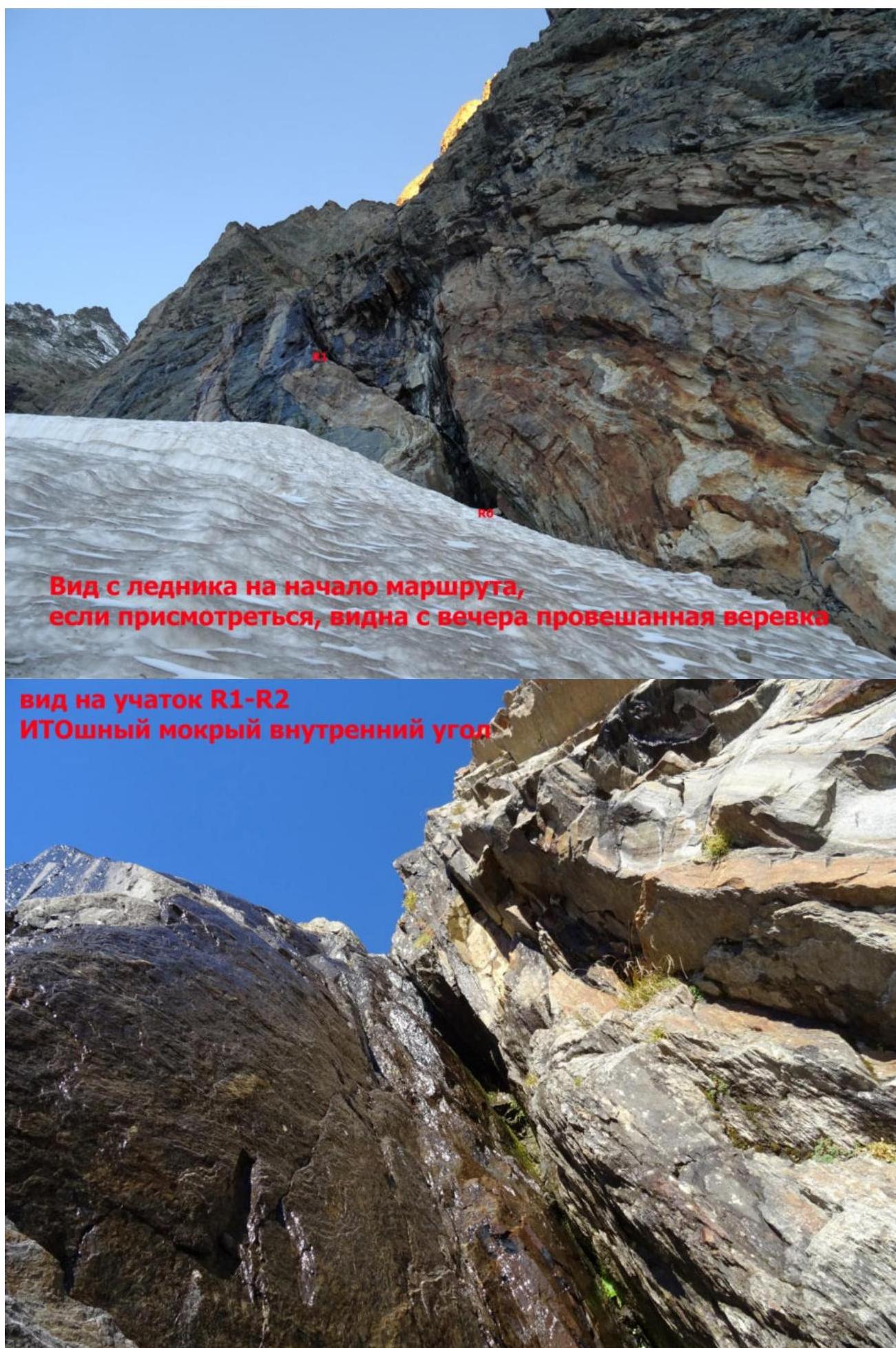 View from the glacier to the start of the route; the pre-hung rope is visible; view of section R1–R2; ITO on the wet internal corner
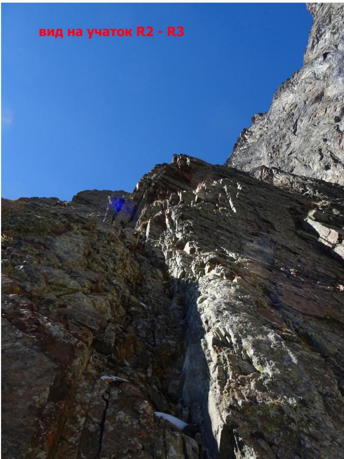 View of section R2–R3
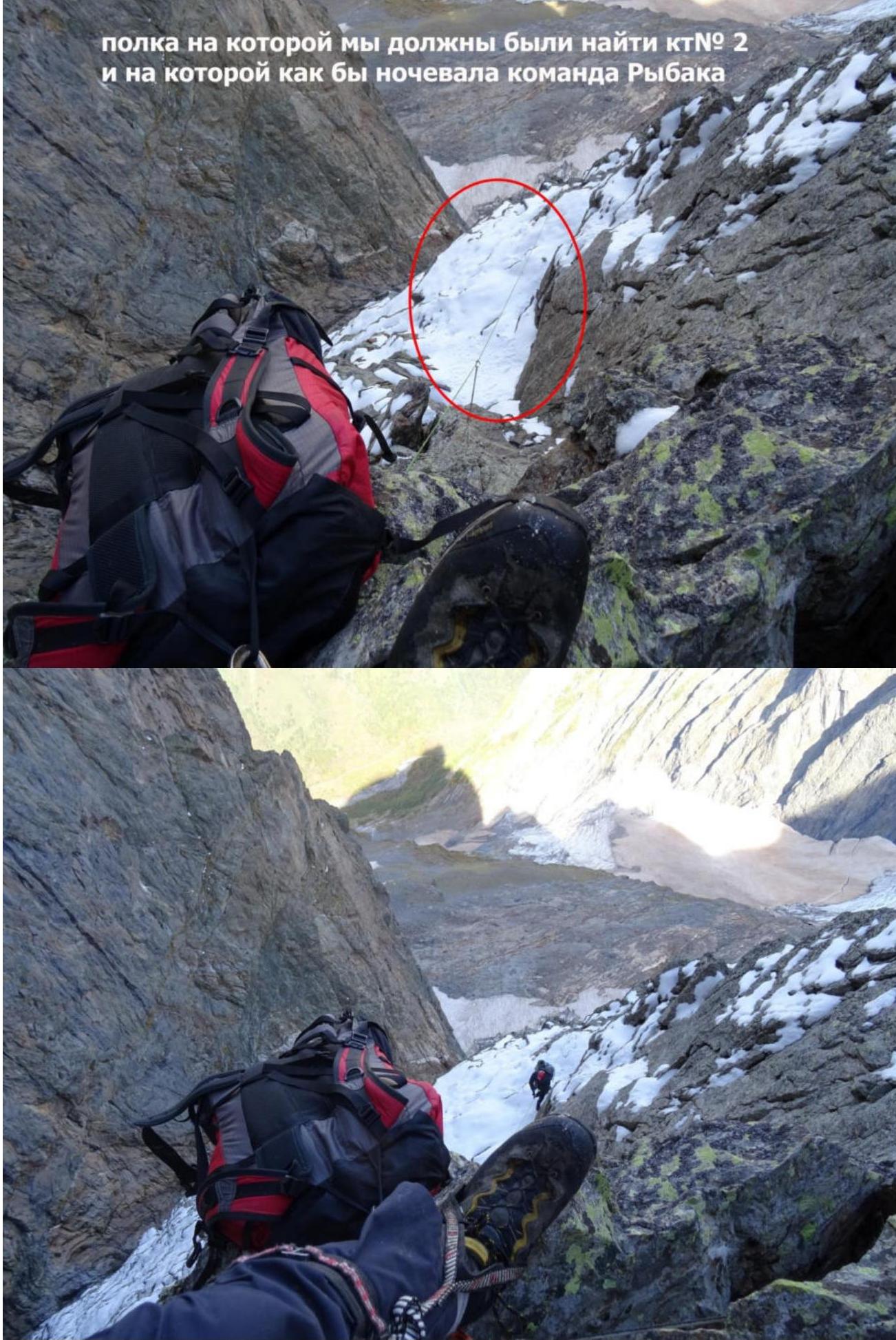 Ledge where we were supposed to find CP № 2, allegedly used by Rybak's team for bivouac
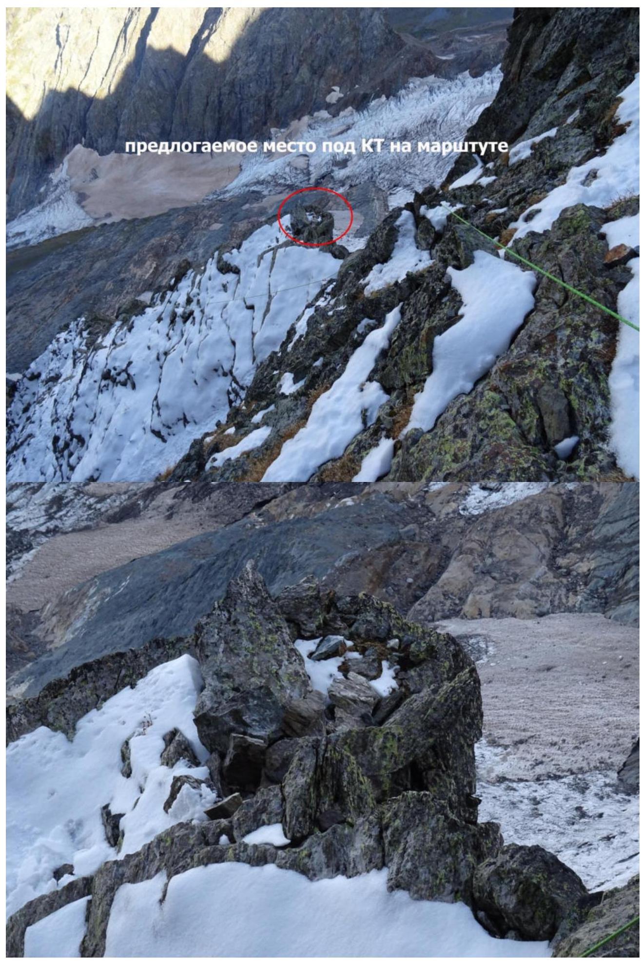 Proposed location for a CP on the route
 Spot where the counterfort turns right; one more rope, and we'll exit onto the southern ridge 3B
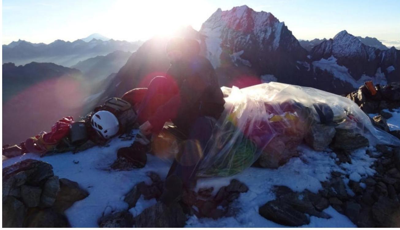 Exit point onto the southern ridge. Morning on the summit, Ankudinov A. I. in the photo
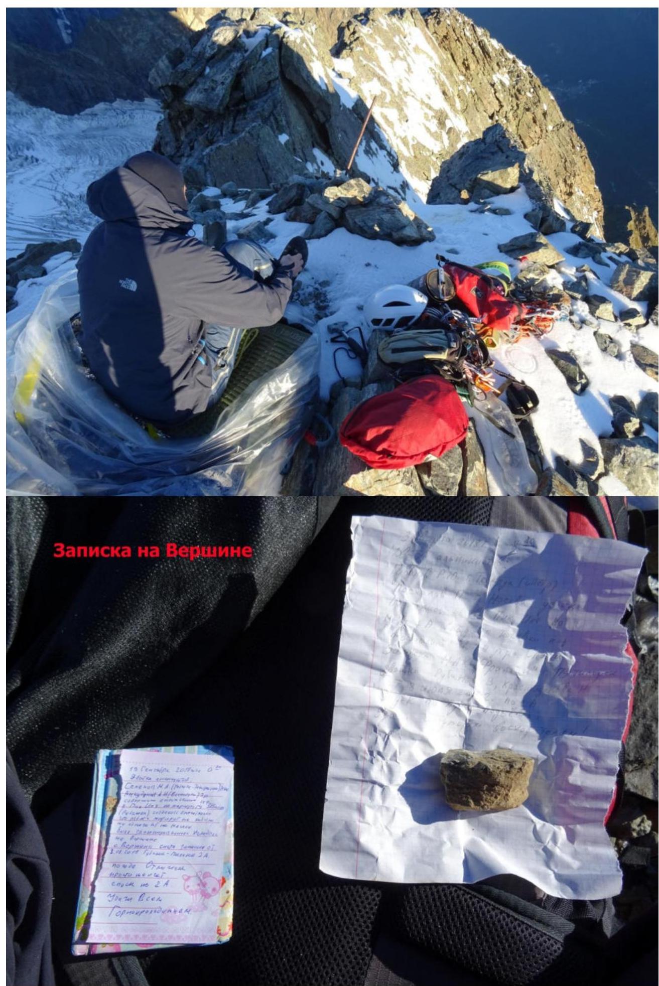 Note on the summit
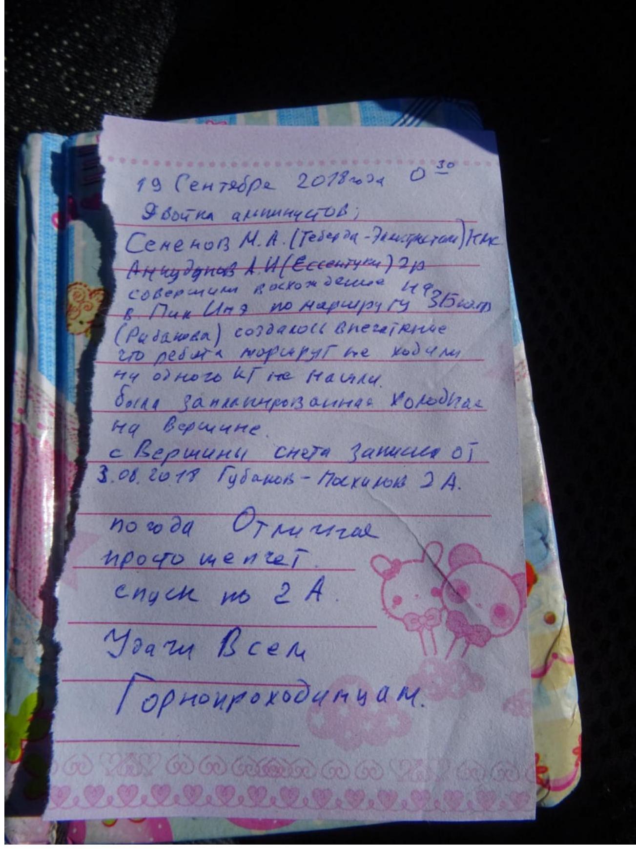
Text of the note: September 19, 2018 00:30 Two climbers: Semyonov M. A. (Teberda — Elektroсталь) CMS Ankudinov A. I. (Yessentuki) 2nd sports category Completed ascent on Pik Ine via route 3B category (Rybakov's). It seemed that the guys didn't climb the route, didn't find a single CP. Planned a cold bivouac on the summit. Found a note on the summit from August 3, 2018. Gubanov – Pakhimov 2A. Weather is excellent, just perfect. Descent via 2A. Good luck to all mountain climbers.
Acknowledgments for help with the report:
Shipilov Vyacheslav Alexandrovich Gubanov Roman Yuryevich Kuznetsova Ekaterina Alexandrovna Semyonova Olesya Artemovna And to everyone who didn't interfere :))))
Team leader: Semyonov M. A. Participants: Ankudinov A. I.
Coaches: Shipilov V. A. Motienko N. I.
Comments
Sign in to leave a comment