
To the Classification Commission of the USSR Alpine Federation
REPORT
on the first ascent to the Sofruju peak via the southern wall on July 27-29, 1972
I. Group Composition:
Gubanov Yu. D. — leader, Candidate for Master of Sports, senior instructor of the Dombay region Climbing School, unattached, "Burevestnik" Sports Society, Dombay settlement.
Prima Yu. V. — participant, Candidate for Master of Sports, radio instructor of the Dombay region Climbing School, unattached, "Burevestnik" Sports Society, Dombay settlement.
Khamtsov A. P. — participant, 1st class, junior instructor, unattached, "Burevestnik" Sports Society, Dombay settlement, Alibek alpine camp worker.
Support group led by Candidate for Master of Sports Vorobyev D. G., parallel route on the Main Amanauz peak via the southern wall, category 5B difficulty.
II. Alpine and Geographical Overview of the Sofruju Massif.
The Sofruju massif is located on the section of the Main Caucasian Ridge between the Sofruju and Amanauz passes and has two distinct peaks: northern and southern. The peak area is covered by a glacier flowing north, west, and east. To the south, it drops steeply into the South Amanauz cirque (see appendix: map and photographs). There are existing routes on the Sofruju peak (3785 m):
- From the Sofruju glacier, category 1B difficulty, snow and ice route.
- From the Amanauz pass, category 2B difficulty, combined route.
Both routes are very popular in the Dombay region for beginner climbers. Until recently, there were no routes on the southern walls of the Sofruju massif. Since 1956, there has been a category 5B difficulty route from the southern cirque to the Main Amanauz peak (first ascenders: G. Japaridze and B. Romanov's group).
The Amanauz southern walls are similar to Sofruju's, but the latter are longer. Our group aimed to start exploring the southern walls of Sofruju, which are no less challenging than Amanauz. In 1967, the group leader, Gubanov, observed these walls from the Abkhazian Ridge.
In 1971, Yu. Gubanov and Yu. Prima, while ascending the Main Amanauz peak via the southern wall (category 5B), identified potential routes from the south to Sofruju. We decided against the wall leading directly to Sofruju due to its high rockfall risk and lesser sporting interest because of its gentler slope (see attached photo #1).
We plotted a route to the Southwest shoulder of Sofruju (3700 m), choosing the most logical and safe path on these walls (see photos).
III. Ascent Details.
July 27, 1972. Approach Day.
Very early departure from Dombay поляna and approach to the Amanauz pass (3400 m). After rest, descent from the pass and approach under the Sofruju wall. Organization of a bivouac on the grassy moraine under the wall. Observation of the wall. Working hours: 14-15. Weather: excellent at first, rain by the end of the day.
July 28, 1972. Ascent Day.
Early start on the wall and passage of the lower part (sections #1 and #2). Organization of a bivouac on the wall. Working hours: 9. Weather: good initially, hail with snow after noon.
July 29, 1972. Ascent Day.
Relatively early start (cold rocks) from the bivouac on the wall, passage of the remaining part (sections #3 and #4), reaching the summit (section #5), and descent from Sofruju via the category 1B route to the Upper Sofruju bivouac. Working hours: 10-12. Weather: excellent all day. A note from 1945 by the Zheldorproekt NKVD group led by senior climbing instructor Chasovnikov was found on the Southwest shoulder of Sofruju.
IV. Safety Measures.
Since the ascent was made by a single rope team (three climbers), the group maintained radio contact (according to the Climbing School's schedule) with the support group (led by Vorobyev D. G.). The support group, in turn, had contact with their observers (on the Amanauz pass), and the observers with the Dombay region Climbing School. For backup, the group had flares. Key aspects of the ascent organization and tactics included: moving on a double rope (the middle climber with a prusik knot), lightening the first climber's rucksack, and pulling rucksacks on difficult sections.
V. Route Description.
To the Amanauz pass — as per F. Kropf's book "Western Caucasus". From the Amanauz pass — right — up along the ridge to a small firn plateau under the ridge ascent to Sofruju (category 2B route) — 15-20 minutes.
From the plateau — straight — down through the left part of a wide rocky couloir (snow in early summer), using shelves with scree. The couloir becomes steeper in its lower part. 30 m of slabs follow. A rappel to the South Amanauz glacier. Along the glacier, left — down, under Amanauz walls — to a long moraine visible from above. From the moraine, the route on Sofruju via the southern wall is visible in profile. Along the moraine ridge — down, to the level of the lower part of Sofruju's southern walls, then traverse right along grass and "ram's foreheads" with scree (icefalls above) — to a rocky, grassy, not clearly defined counterfort of Sofruju's southern wall. Under the counterfort, on an old, overgrown moraine — bivouac site, water. Section: Amanauz pass — base of the wall — 2-3 hours.
VI. Recommendations for Climbers.
- Number of participants in the group: 4-5 people.
- Best time for ascent: July-August.
- Initial bivouac: under the base of the wall's counterfort.
- Departure time from bivouac: 5:00 AM.
- Special equipment (for a group of 4):
- Main rope — 3 × 40 m.
- Rock pitons — 25-30 pieces.
- Carabiners — 15-20 pieces.
- Hammers — 2 pieces.
- Ladders — 2 pieces.
- "Vibram" boots or galoshes — 1 pair. Crampons and ice pitons necessary in the second half of summer for the Amanauz pass ascent.
- Water supply needed for the route in the second half of summer.
VII. Route Characteristics.
Section #1 (steep part of the counterfort) — rocky, quite complex. Length: 600 m. Average steepness: 50°-55°. Rocks are fairly solid, rich micro-relief, many cracks for pitons. Some small, crumbling sections and "live" rocks. Movement mostly with alternating belay. Belay mainly with pitons and also through ledges. 15-20 rock pitons used. Bivouac sites can be found.
Section #5 (summit ridge) — snow-firn, easy, simple. Length: not less than 500 m. Average steepness: practically flat, except for the summit ascent. Wide firn ridge, limited on the right by walls, transitions to a slope on the left. Simultaneous movement. No pitons used. Bivouacs possible almost anywhere.
The entire Sofruju route is rock-combined, long (about 1000 m vertical ascent measured by altimeter), difficult, and technically complex.
All first ascenders rated it category 5B difficulty.
VIII. Appendices.
- PHOTO #1 (Southern walls of Sofruju with Amanauz pass and South Amanauz cirque, as well as part of the Jessar glacier and Amanauz ridge). Taken in October 1965 from the Abkhazian Ridge by the southern team of the Dombay expedition of the Geography Faculty of Moscow State University using a phototheodolite. The photo gives a clear representation of the wall's relief after a snowfall. This is the only good photo of Sofruju's southern wall available to the group.
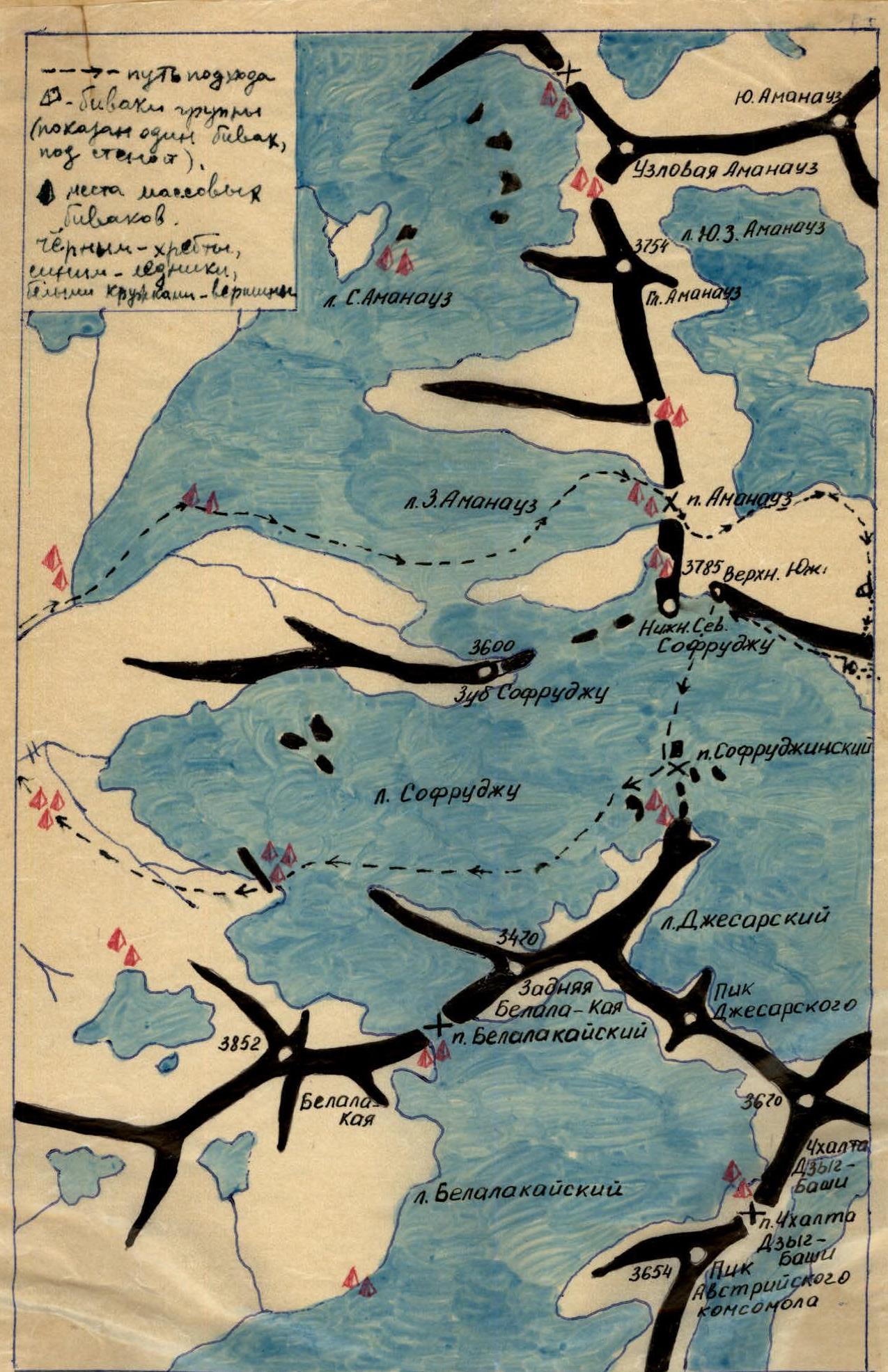
Legend for the map:
- Path approach (dashed line)
- Group bivouacs (triangles)
- Mass bivouac sites (diamonds)
- Black — ridges
- Blue — glaciers
- Peaks (circles with labels)
Group Leader: Gubanov Yu. D. Participants: Prima Yu. V., Khamtsov A. P.
Comments
Sign in to leave a comment