
104
Central Council of the "Trud" Voluntary Sports Society
"Krasnaya Zvezda" Alpine Camp
Report
on the first ascent of the Northwest wall of Kara-Kaya Main peak (approximately category 6B)
Team members:
- USSR Master of Sports Andreev R.N. - team leader
- Assorov A.V. - participant
- Shkrabkin A.S. - participant
- Tsirkunov V.S. - participant
Team coach - USSR Master of Sports Salakin V.P.
1965
One of the most interesting regions of the high-mountain Western Caucasus - the Aksaut region - is barely represented in literature. The Kara-Kaya massif is located in this region. Its main peak (3896 m) - a huge rock pyramid - rises north of the Main Caucasian Range in the Mysti-Bashi spur. All peaks of the Kara-Kai massif form a sheer horseshoe-shaped wall surrounding the upper cirque of the Northern Marukh glacier. Any ascent up this wall, except for the North Kara-Kai saw, is not lower than category 5B. The most challenging and interesting ascent from a sporting perspective is the northwest wall of Main Kara-Kaya. The region's low level of exploration in terms of mountaineering is likely due to its significant remoteness and low population density in the Aksaut valley.
The Aksaut region is characterized by highly unstable weather. Good weather usually holds during the first half of the day. By 12:00, the upper half of the Kara-Kaya massif is typically shrouded in clouds.
Despite the region's remoteness, the northwest wall of Kara-Kaya has attracted the attention of sports groups over several years and has been repeatedly filed for the Union championship.
The object of the ascent was chosen based on photographic materials and consultations. To gather more detailed information about the object and to develop a tactical plan for the ascent, a reconnaissance was conducted by a group consisting of:
- Andreev R.N.
- Assorov A.V. on July 3-7, 1965.
As a result of this reconnaissance, the approach routes to the ascent area and the ascent route itself were clarified. The planned ascent schedule was adhered to based on the reconnaissance findings (see the route sheet).
The team included sports instructors from the Central Council of the "Trud" Voluntary Sports Society working at the "Krasnaya Zvezda" Alpine Camp.
After clarifying the route based on the reconnaissance materials, the team deemed it necessary to conduct a training ascent to the Main Amanauz peak via its southern wall (category 5B), considering that the rock relief of the lower part of the Amanauz wall is similar to that of the Kara-Kaya wall.
The planned training ascent was successful.
During preparations for the ascent to Kara-Kaya, team member Savin V.N. fell ill and had to withdraw from the ascent. There was no time to wait for his recovery. Team member Potapov A.N., being Savin V.N.'s partner in the rope team, also did not participate in the main ascent.
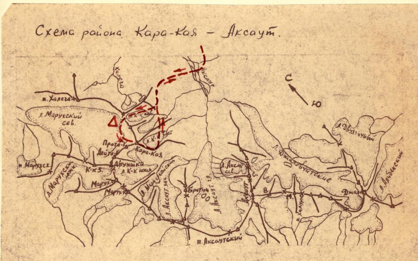
Map of the region. Kara-Kaya - Aksaut.
 Route map to the Main peak of Kara-Kaya.
--- ascent path.
Δ — base camp under the northwest wall.
On July 25 at 6:00, the team and the observation group left the "Krasnaya Zvezda" Alpine Camp for the upper Aksaut valley by car.
Upon arrival, they found that part of the bridge across the Aksaut river had been washed away, making it impossible to cross.
Driving further up the valley to the end of the road, they decided to ford the river. At that moment, two local shepherds on horseback passed by and helped the group cross the Aksaut river.
Without delay, they ascended via a familiar trail to the North Kara-Kai pass and spent the night there.
On July 26, they reached the North Kara-Kai pass in an hour and descended to the base camp site on rock outcrops under the Kara-Kaya wall.
Route map to the Main peak of Kara-Kaya.
--- ascent path.
Δ — base camp under the northwest wall.
On July 25 at 6:00, the team and the observation group left the "Krasnaya Zvezda" Alpine Camp for the upper Aksaut valley by car.
Upon arrival, they found that part of the bridge across the Aksaut river had been washed away, making it impossible to cross.
Driving further up the valley to the end of the road, they decided to ford the river. At that moment, two local shepherds on horseback passed by and helped the group cross the Aksaut river.
Without delay, they ascended via a familiar trail to the North Kara-Kai pass and spent the night there.
On July 26, they reached the North Kara-Kai pass in an hour and descended to the base camp site on rock outcrops under the Kara-Kaya wall.
After setting up tents and resting, the pair Andreev - Assorov started processing the lower part of the wall at 11:50. They ascended a snowy slope (section R0-R1, see photo and table of main ascent route characteristics) to a bergschrund. Descending 10 m into the bergschrund, they hung a ladder on the sheer wall and ascended under an overhanging ice cornice (section R1-R2). Then, they ascended a sheer ice gully to a snowy slope. Climbing the slope (section R2-R3), they reached the rocks. The rock wall, with a steepness of 75°–90°, is composed of gray strong granite with many overhanging sections. The ascent begins by going up to the right (section R3-R4) via steep rocks, 10 m with good holds and 30 m across smooth rocks. Further, a very complex traverse to the right under an overhanging ledge is required. The ledge was overcome with the help of a boost. By this time, the weather had deteriorated, and it started raining.
The subsequent ascent directly upwards via difficult rocks for 40 m involves overcoming two sheer sections. Here, the rope was secured, and the pair descended to the tents by rappel by 17:00.
On July 27, the weather was excellent in the morning, and at 5:00, the team - in two pairs, Tsirkunov-Shkrabkin and Assorov-Andreev - set out on the route.
By 8:00, they had overcome the processed section of the wall via the fixed ropes (section R0-R4). The further ascent upwards for 40 m (section R4-R5) - via very difficult rocks - leads to a 20-meter sheer wall (section R5-R6). The first climber processed and overcame it using ladders and a platform. The others ascended via a 20-meter ladder, followed by pulling up their backpacks using a block. The next section is a 150-meter wall (section R6-R7). Ladders were used three times, and backpacks were pulled up.
Ascending destroyed rocks of medium difficulty (section R7-R8), they reached a smooth slab (section R8-R9), which was overcome directly with subsequent traverse to the right to an internal corner. The slab is climbed using ladders and additional pitons for holds. The internal corner, with a steepness of 85°, is overcome with careful belaying and cautious climbing (loose rocks), leading to a main inclined ledge. The weather starts to deteriorate, the entire wall is enveloped in fog, followed by rain, hail, and later wet snow until evening (21:00). Wet rocks become even more challenging and hazardous. From the inclined ledge directly upwards, slightly to the left, via very difficult smooth rocks (section R9-R10). All participants climb without backpacks; in two places, the wall is overcome using ladders and additional support from pitons.
Next, they traverse a 35-meter gully (section R10-R11), with belaying via ledges and pitons, leading under an overhanging 3-meter slab. Ascending onto the slab, they reach a steep buttress.
Time: 20:30. Conditions:
- Everyone is soaked
- Wet snow is falling
They immediately start leveling a platform and, after working for about 2 hours, manage to create a semi-reclining bivouac.
On July 28 at 8:00, the pair Andreev - Assorov set out to further process the route and clarify the ascent path. The second pair, Shkrabkin - Tsirkunov, remained to expand the platform and set up a tent. They ascended the buttress wall for 60 m to a ridge (section R11-R12) and reached a gentle platform. Here, a good platform can be organized.
From here, a logical ascent path is planned:
- along the ridge and then directly upwards under the summit tower.
There is an alternative ascent route previously considered, but it requires:
- descending from the ridge to the other side for 50–60 m into a narrow couloir, which is often subject to rockfall;
- ascending 30 m upwards via steep, smooth inclined ledges;
- traversing them to the right for 120–150 m;
- reaching under a sheer wall;
- ascending to the pre-summit ridge using pitons and platforms.
After assessing the route and weather conditions, the team decided to continue the ascent via the logical path - along the ridge and then upwards under the summit tower. After securing the rope, the pair descended to the tent by 10:30. By this time, the weather had started to deteriorate, and soon it began raining, which continued until evening.
At 21:30, a massive rockfall occurred from the ridge between Dvuska and West Kara-Kaya, accompanied by a deafening roar, repeating four times over about 20 minutes.
On July 29, in good weather, the team set out on the route at 6:00. Ascending via the fixed ropes to the ridge (section R11-R12), they left a control cairn on the platform. Then, traversing the ridge (section R12-R13), they approached a 5-meter wall, which they overcame using ladders, and reached inclined slabs (section R13-R14). Ascending an intricate gully (section R14-R15), they reached smooth slabs (section R15-R16), which led to sheer difficult rocks (section R16-R17). At this time, the weather deteriorated again, with heavy snowfall. Ascending the rocks with careful piton belaying, they reached an inclined ledge (section R17-R18), covered with rimed ice. Continuous snowfall began.
They could not stop for a bivouac or wait out the bad weather because:
- there was no suitable location between the ridge where they bivouacked and the pre-summit ridge;
- and also due to the risk of rockfall with worsening weather.
They ascended the inclined ledge under the summit tower. To overcome it, they had to:
- cut steps;
- use ice and rock pitons.
Under the summit tower, they entered a chimney (section R18-R19), ending in an overhanging corner, which was overcome with additional handholds. Under the wall of the summit tower, they traversed to the right under a gap in the pre-summit ridge, with a slight gain in height (section R19-R20). The traverse was very difficult and complicated by heavy snow cover and continuous snowfall.
The ascent to the gap on the ridge (section R20-R21) was via difficult snowy rocks. Descending 10 m south from the ridge, they organized a platform from a large number of rocks. On July 30, they ascended to the summit at 9:00 via the heavily snowy pre-summit ridge.
They signaled to observers with a flare and began their descent via the southwest ridge at 9:45. They descended into the Aksaut valley by 16:30, where their observers were waiting.
On August 1, they forded the river and returned to the "Krasnaya Zvezda" Alpine Camp by car.
Table
Main characteristics of the ascent route
Ascent route - northwest wall of Kara-Kaya Main peak.
Height difference of the route - 1130 m.
Including the most challenging sections - 860 m.
Steepness of the route - 75°.
Including the most challenging sections - 80°.
Dates
| Sections | Average steepness of the section | Section height (m) | Terrain characteristics | Technical difficulty | Belay method | Weather conditions | Time | Pitons used (total) | Piton type (rock) | Piton type (ice) | Bivouac conditions | Daily ration weight |
|---|---|---|---|---|---|---|---|---|---|---|---|---|
| Processing the lower part of the wall | ||||||||||||
| R0-R1 | 40°–50° | 70 | Snowy slope | Easy | Simultaneous | Partly cloudy | 11:50, 30 min | — | — | — | — | — |
| R1-R2 | 80° | 30 | Overcoming bergschrund | Difficult climbing with ladders | Alternating | —"— | 30 min | — | — | — | — | 1 |
| R2-R3 | 55°–60° | 60 | Snowy slope | Medium | Alternating via ice axe and pitons | —"— | 15 min | 2 | — | — | — | — |
| R3-R4 | 80°–85° | 80 | Rock wall with 3 overhanging sections | Difficult climbing | Alternating piton belay | Overcast with subsequent rain | 2 h 10 min | — | — | — | — | — |
| Descent to bivouac via rappel | ||||||||||||
| Clove hitch knot | Rain | 17:00, 2 h | — | — | — | On moraine | — | |||||
| Ascent via fixed ropes on the processed wall section | ||||||||||||
| R4-R5 | 80°–35° | 40 | Rock wall with smooth rocks | Difficult climbing | Lateral piton belay | Partly cloudy | 1 h | 4 | — | — | — | — |
| R5-R6 | 90° | 20 | Sheer smooth wall | Difficult climbing with ladders and platforms | — | Partly cloudy | 1 h | 9 | — | — | — | — |
| R6-R7 | 75°–85° | 150 | Rock wall with 3 overhanging sections | Difficult and complex climbing with ladders | —"— | —"— | 3 h | 22 | — | — | — | — |
| R7-R8 | 60°–65° | 50 | Destroyed rocks of medium difficulty | Cautious difficult climbing | Alternating piton and ledge belay | Overcast | 30 min | 2 | — | — | — | — |
| R9-R10 | 80°–90° | 80 | Sheer smooth wall with 2 complex overhanging sections | Complex climbing with ladders | Alternating piton belay | Overcast, fog | 2 h 30 min | 19 | — | — | Semi-reclining on steep buttress | — |
| R10-R11 | 80° | 35 | Sheer rock gully with overhanging slab | —"— | —"— | Fog, wet snow | 20:30, 1 h 30 min | 7 | — | — | — | — |
| Reconnaissance and processing of the upper part of the route | ||||||||||||
| R11-R12 | 65° | 60 | Rock wall leading to ridge | Difficult climbing | Alternating piton belay | Overcast | 8:00, 1 h | 5 | — | — | — | — |
| Descent to bivouac via rappel | ||||||||||||
| 10:00, 30 min | Same as above | — | ||||||||||
| Ascent via fixed ropes on the processed section | ||||||||||||
| R12-R13 | 15 | Ridge length 80 m with 15 m height difference and 5 m wall | Medium rocks, wall overcome with ladders | Alternating piton and ledge belay | Overcast | 6:00, 1 h 45 min | 4 | — | — | — | — | |
| R13-R14 | 60°–70° | 30 | Inclined slabs | Difficult climbing | Alternating piton belay | Overcast, fog | 45 min | 3 | — | — | — | — |
| R14-R15 | 60°–70° | 30 | Intricate rock gully | Medium rocks | —"— | —"— | 20 min | 3 | — | — | — | — |
| R15-R16 | 60°–65° | 50 | Smooth slabs | Difficult complex climbing | —"— | Fog, snow | 1 h | 6 | — | — | — | — |
| R16-R17 | 75°–80° | 70 | Sheer difficult rocks | Difficult climbing with step cutting | —"— | Fog, heavy snow | 1 h 30 min | 12 | — | — | — | — |
| R17-R18 | 55°–65° | 70 | Inclined ledge covered with rimed ice and rock outcrops | Difficult climbing with step cutting | —"— | Continuous snowfall | 1 h 30 min | 9 | 2 | — | — | — |
| R18-R19 | 80°–90° | 10 | Rocks leading under the summit wall | Difficult climbing with ladders | Lateral piton belay | Continuous snowfall | 40 min | 4 | — | — | — | — |
| R19-R20 | 80°–90° | 40 | Traversing along inclined ledge covered with rimed ice with smooth ledges to the right under a gap in the pre-summit ridge. Length 150 m with 40 m height gain. | Difficult complex climbing with step cutting | —"— | Heavy snow and wind | 3 h 30 min | 12 | 3 | — | — | — |
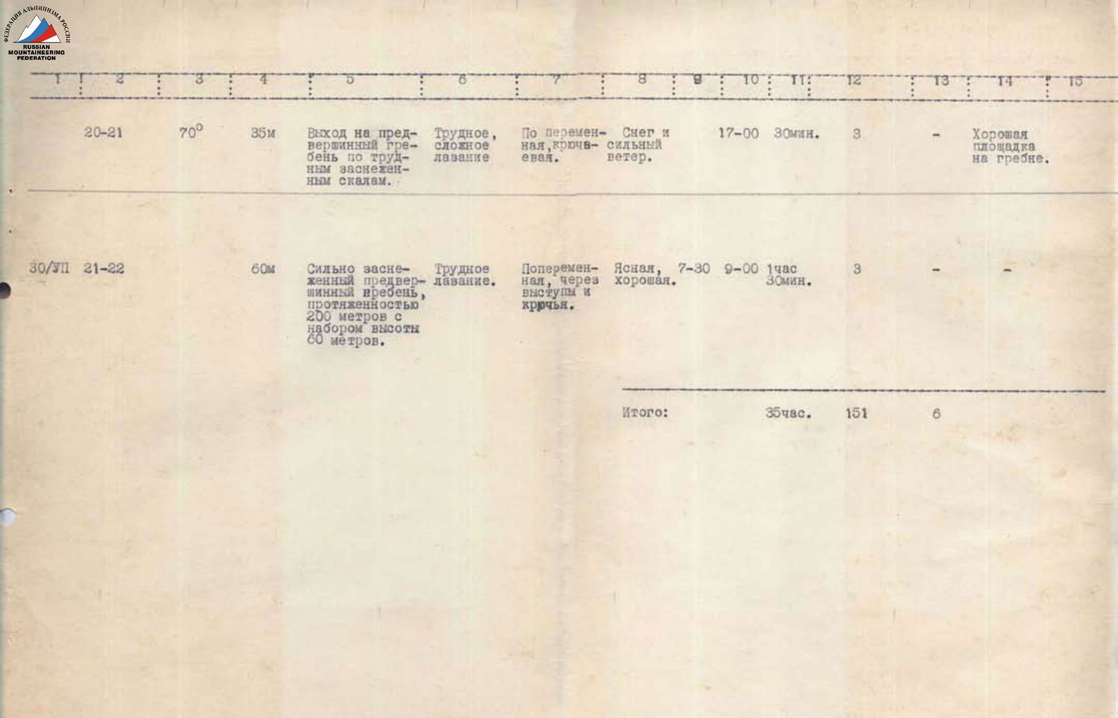
| R20-R21 | 70° | 35 | Ascent to pre-summit ridge via difficult snowy rocks | Difficult complex climbing | Alternating piton belay | Snow and strong wind | 17:00, 30 min | 3 | — | — | Good platform on ridge | — |
|---|---|---|---|---|---|---|---|---|---|---|---|---|
| R21-R22 | 60 | 60 | Heavily snowy pre-summit ridge, length 200 m with 60 m height gain | Difficult climbing | Alternating via ledges and pitons | Clear, good | 7:30, 9:00, 1 h 30 min | 3 | — | — | Same as above | — |
Total: 35 h. Pitons used: 151. Total number of bivouacs: 6.
Comments
Sign in to leave a comment