
Fig. 53
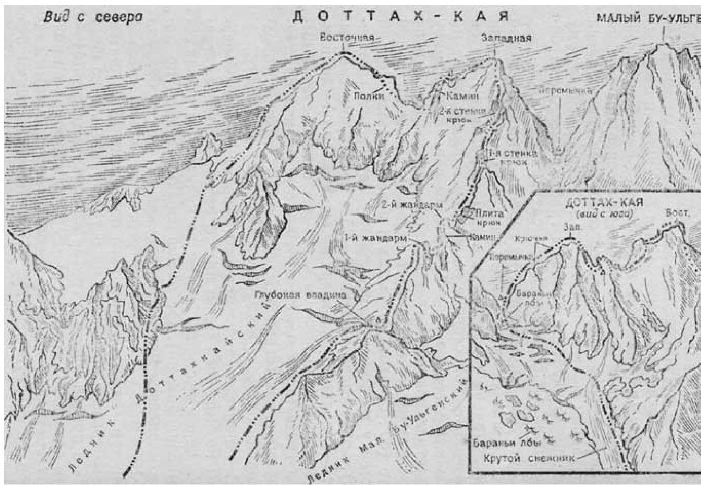
1. Traversing the Dottakh-kaya peaks (3670 m) with ascent to the Western summit via the northwestern ridge (cont. fors) — category 4A difficulty (fig. 53)
From Dombay, by car to the Bu-Ulgen plain or on foot through the Chuchkhur pass. From the Bu-Ulgen plain to the confluence of the Dottakh-kaya and Bu-Ulgen rivers and across the snow bridge (fordable at the end of summer) over the Bu-Ulgen River. Then along the Dottakh-kaya River upstream to the base of the northwestern ridge. Further:
- detour around the base of the ridge from the left via the "ram's foreheads",
- ascent via the moraine and a small snowpatch to a deep depression in the ridge — a bivouac site, water.
From the Bu-Ulgen plain, 4–4.5 hours.
From the bivouac, up to the ridge to the right and along it straight up (or bypassing certain sections) to the first sentinel rock. Ascent to the sentinel rock head-on (belay!), descent from it on the right side via ledges and back onto the ridge. Ascent to the second sentinel rock from the right via a 6-meter chimney (pitons for belay!), then traverse left and exit onto the ridge via slabs (belay!). Further, via a steep slab (60°, belay!) to the first wall. Ascent up the wall via a 20-meter chimney (pitons for belay!), then traverse left 20–25 meters across loose rocks. Then via a ledge up to the right onto the ridge, ascent via slabs to a snowpatch and along it to the left under the second wall, 120 meters high (wall steepness 70 — 75°). Ascent up the wall straight (pitons for belay!), exit onto the pre-summit ridge and along it to the Western summit.
From the Western summit, descent towards the Eastern summit via loose rocks on the right side of the ridge (belay via protrusions!), then via a couloir to a platform (rockfall hazard!). 60 meters ahead from the platform — a safe place for a bivouac.
From the bivouac site:
- 10–15 meters back and ascent to the ridge via moderately difficult rocks;
- from the ridge, down to the left via a chimney (5 meters), then to the right — traverse via ledges onto a sharp ridge;
- along the sharp ridge, descent into a depression (rappel descent from the ridge into the depression) — a place for an overnight stay.
From the depression:
- 40–50 meters up to the right via ledges (belay!);
- exit onto the ridge and via несложным скалам на Восточную вершину.
From the Western summit — 3–4 hours.
From the Eastern summit, down along the left ridge via разрушенным скалам (местами спуск dюльфером), exit onto a snowpatch in the lower part of the ridge. Certain sections of the ridge are bypassed on the left or right.
From the snowpatch, there are two descent options.
1st option. With good snow conditions and a bergschrund, descent via a rocky couloir (rockfall hazard!) onto the Dottakhkay glacier snow plateau, then to the overnight stay site near the depression of the northwestern ridge and further along the ascent route to the Bu-Ulgen plain.
2nd option. With poor snow cover and a bergschrund, descent from the snowpatch on the right side of the ridge via talus ledges (rockfall hazard, belay!) of the Eastern summit of Dottakh-kaya. Down via a snowpatch (belay!) and exit onto the Dottakhkay glacier. Further descent as per the first option.
Recommendations for climbers
- Number of participants in the group — no more than 6 people.
- Initial bivouac — on the "ram's foreheads" near the deep depression of the Ridge.
- Departure time from the bivouac — no later than 5:00 AM.
- Special equipment for a group of 4 people: a) main rope 2×30 meters; b) expendable repp cord 8–10 meters; c) rock pitons — 10–12; d) ice pitons — 2; e) rock hammers — 2; f) carabiners — 12; g) crampons 4 pairs (in the second half of summer).
- Possible bivouac sites: 1st — on the ridge behind the first sentinel rock under the second wall; 2nd — under the Western summit; 3rd — behind this summit; 4th — behind the deep depression.
Comments
Sign in to leave a comment