Ascent Passport
- Russia, Caucasus.
- Rock class.
- Western Caucasus, from Marukh pass to Nakhar pass, section 2.2.
- Peak Dombay-Ulgen Western (4036 m), through the center of the Triangle of the southern wall.
- Proposed 6B category difficulty, first ascent.
- Route characteristics: height difference: 1036 m, length — 1690 m; length of sections 5–6 category difficulty — 605 m; average steepness of the main part of the route (Triangle South wall) — 84°; start of the route (bergschrund) — ridge — 72° (3000–3920); start of the route (bergschrund) — summit — 66° (3000–4036).
- Pitons driven (including in the denominator for ITO): rock ice bolted protection skyhooks 122/66, 0/0, 47/23 (stations), 95/30
- Climbing hours 73.5 and days — 3 (processing 5).
- Number of nights and their characteristics: Processing — on the pass, comfortable in a tent; 1st — three sitting on inclined shelves; 2nd — three, lying separately on artificial platforms; 3rd — two, sitting on a shelf, one lying on a platform;
- Leader: Pugachev Sergey Alexandrovich — MS; participants: — Volkov Leonid Borisovich — MS; — Zaryansky Grigory Konstantinovich — CMS. Team coach: — Zagirnyak Mikhail Vasilyevich — MS, instructor-methodologist 1st category.
- Approach to the route: June 26, 2006; summit — June 29, 2006, 8:00; return — June 30, 2006.
- Organization — Kharkov Regional Alpine Federation.

PHOTO 1. GENERAL PHOTO OF THE SUMMIT. Shot from point A on the map-scheme. Distance 1000 m.
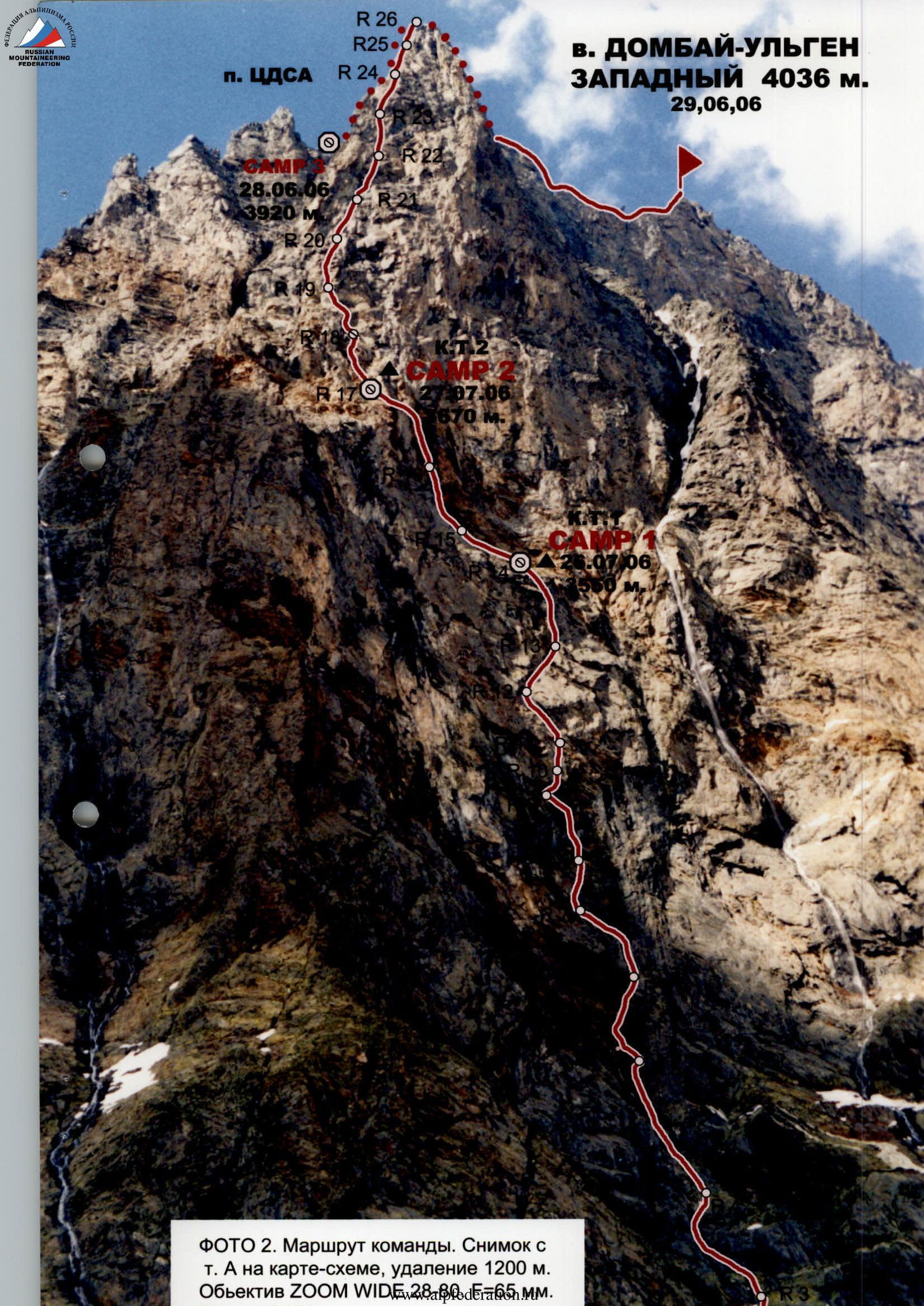
PHOTO 2. Team route. Shot from point A on the map-scheme, distance 1200 m. Lens ZOOM WIDE 28.00, F=65 mm.
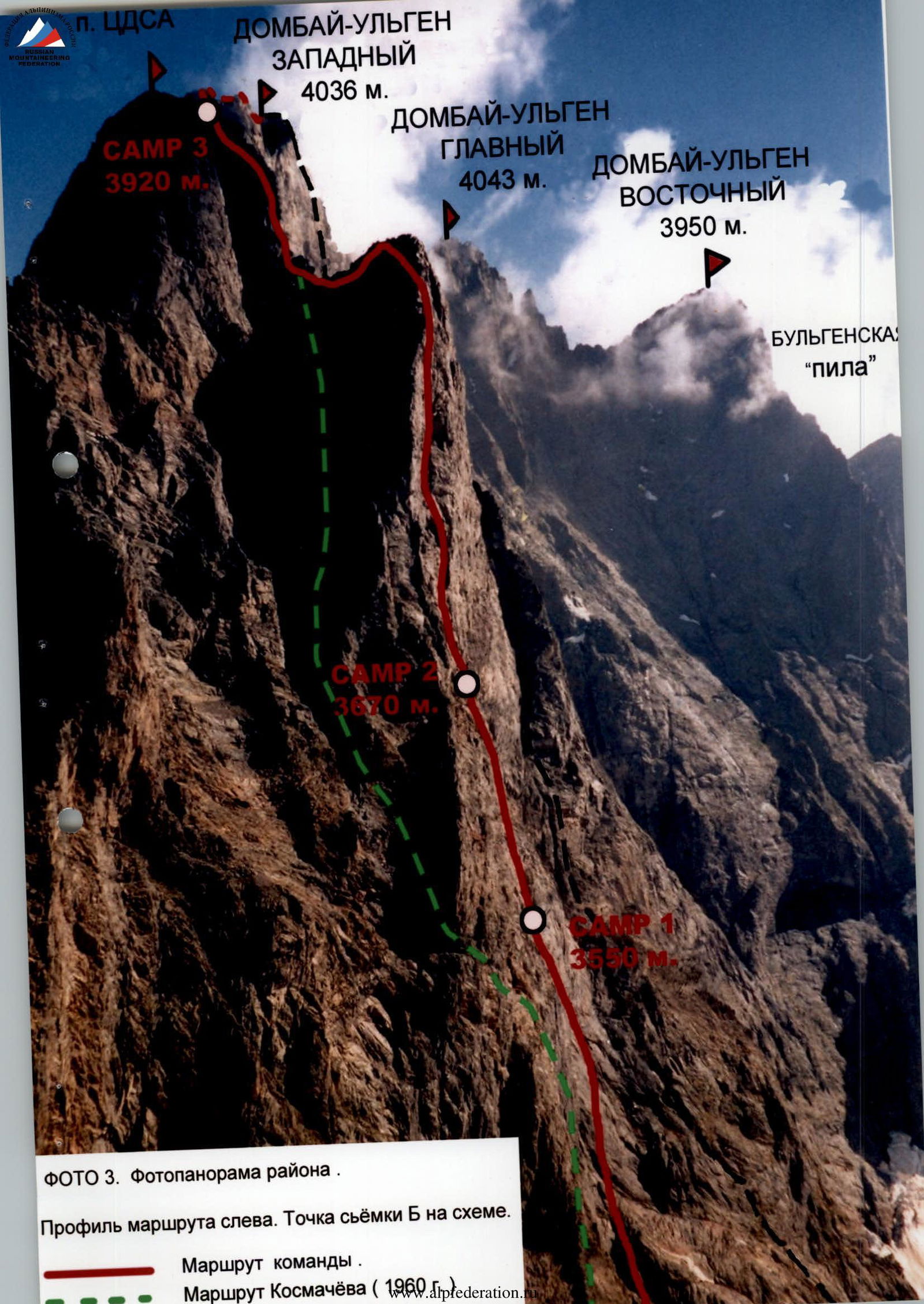
PHOTO 3. Photopanorama of the area. Route profile on the left. Shooting point B on the scheme.
Team route. Kosmachev's route (1960).
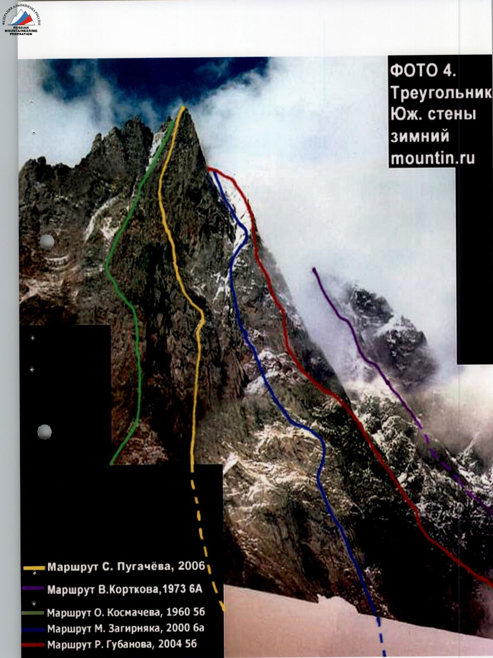
PHOTO 4. Triangle of the South wall in winter

Drawn route profile
Brief description of the approach to the route from the base camp
From Dombay glade along the trail to the right of Chuchkhur waterfalls to Ptysh overnight stay. From Dombay glade 3–4 hours. From Ptysh overnight stay along the moraine of Ptysh glacier upwards (15–20 minutes) and left — exit towards Dombay pass. Ascent along the couloir (or to its right side) and exit to the eastern edge of Kruzhivnoy glacier. Then ascent along the snowy slope, then along the wide couloir and along the right side of the rock ridge to Dombay pass — bivouac. From Dombay glade 6–8 hours.
From the pass down and left along the traverse under the slopes of TsDSA peak, bypassing its bastion, towards the first rock "claw", where Zagirnyak's route begins. 200 m before the "claw", we turn left and along the steep firn (crampons), bypassing the bergschrund on the right, we move towards the rocks like "ram's foreheads", closing the steep 60° snow ascent. From Dombay pass 40 minutes. Along the rocks (belay) and snowy slope (crampons, ice axes) we reach the center of the main rock part of the route — the base of the Triangle of the southern bastion. From the bergschrund another 1.5 hours.
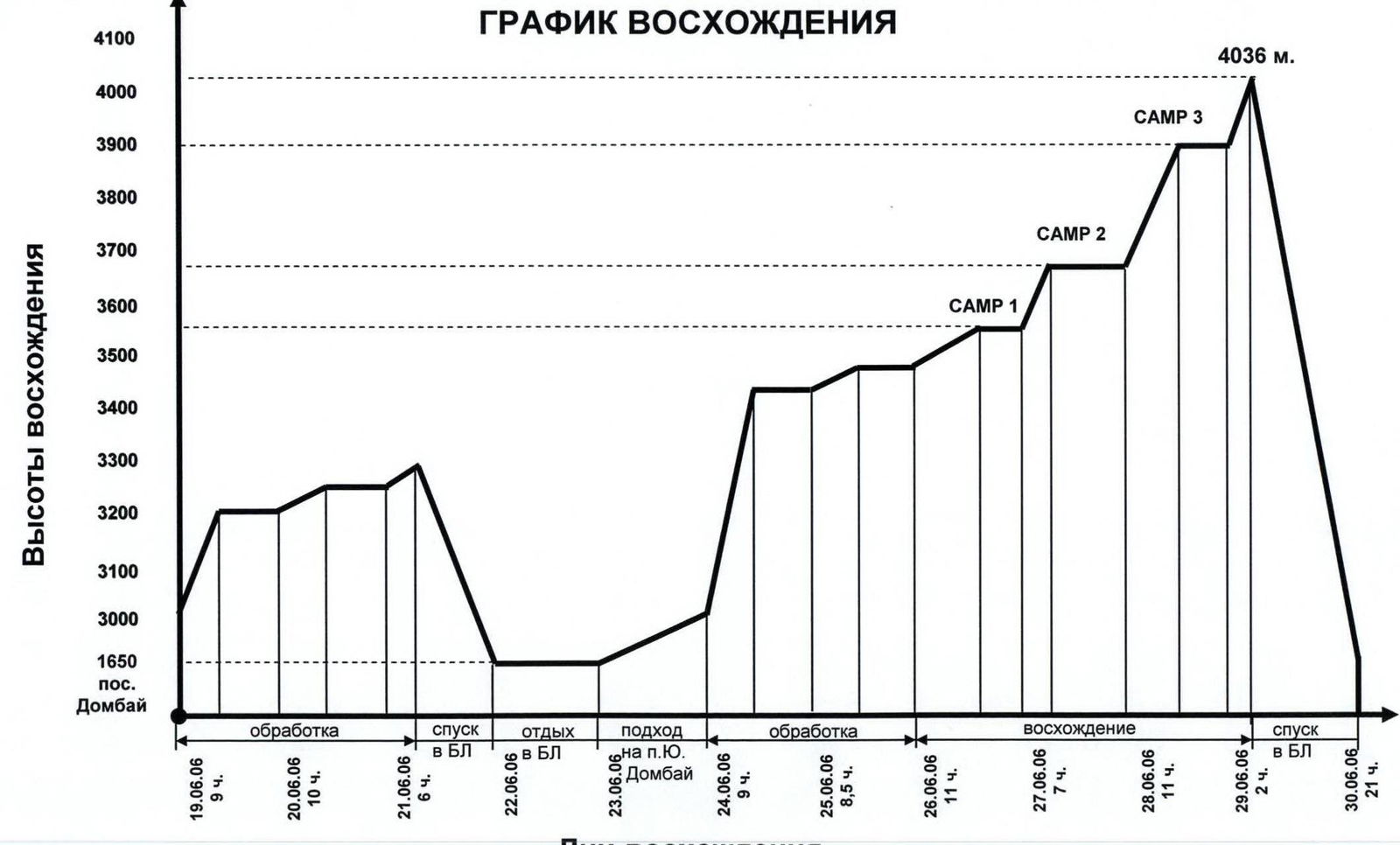
Team movement schedule by sections
June 19, 2006 from 9:30 to 18:30 — start of route processing (sections R0–R7); June 20, 2006 from 8:30 to 18:30 — processing sections (R7–R9), cargo delivery; from 13:00 to 17:00 rain and at night; June 21, 2006 from 8:30 to 14:30 — processing (R9–R10); from 16:30 to 19:30 — return to B.L. (Dombay settlement); June 22, 2006 — rest in B.L. June 23, 2006 — approach to the initial bivouac — South Dombay pass; June 24, 2006 from 8:00 to 17:00 — processing (R10–R11); rain in the evening and at night; June 25, 2006 from 7:30 to 16:00 — processing (R11–R12); ascent and cargo delivery; June 26, 2006 from 8:00 to 19:00 — ascent, exit to R14; overnight stay — CAMP 1; June 27, 2006 from 10:30 to 17:30 — ascent, R14–R16, overnight stay — CAMP 2; processing R16–R18; June 28, 2006 from 8:30 to 19:30 — ascent, R16–R27, overnight stay — CAMP 3; rain from 19:30 and all night; June 29, 2006 from 6:00 to 8:00 — movement along the ridge and exit to the summit; from 9:30 — return to the base camp; rain and lack of visibility from 6:00 to 18:00.
Brief characteristics of the team's tactical actions
The team completed the route in accordance with the tasks arising as they moved along the wall, in three days and with three overnight stays on the wall, in the planned locations. For the successful passage of the route, its processing and delivery of equipment and water were used.
The main part of the route the team moved in the lead with the hanging of ropes by a rope team, and the duties of the rope team — triple — were divided in such a way that the last one, lightened by 30–35%, removed the stations and knocked out the pitons, which allowed without downtime to provide the first one with the necessary equipment and maintain the set pace of movement. To prevent physical and moral fatigue, the leader of the lead rope team was changed every day. Since overnight stays on the section R1–R6 are only possible sitting, and on sections R7–R12 only in hammocks, the team tried to process the maximum number of sections. After the overnight stay in CAMP 1, the subsequent sections (R14–R15) were processed.
On all sections from R3 to R22, the pulling of the haul bag with equipment was carried out using a Mini Traxion device from Petzl.
Almost all sections above 6 category difficulty according to the European classification were climbed with the help of ladders and hook ladders (sections R5–R17). The rest of the route the first climber moved with free climbing, except for sections where rockfall was possible.
The first in the lead rope team moved on a double rope: one — from "Mammut" with a UIAA stamp, diameter 10.2 mm; the second — from Beall, 9.2 mm. The other participants — along the fixed ropes made of static Kaliningrad rope, using top rope belay. Equipment was transferred at the stations.
When passing sections R5–R6, R9–R10, R11–R12, R13–R14, R16–R17, special attention was paid to belaying the first, since on their length cornices and bends did not allow visual control over the leader and there was practically no voice communication.
Thanks to a well-chosen variety and quantity of technical means for overcoming any relief, the team did not have any problems. In the lower part of the route, ordinary rock and petal pitons and small chocks were mainly used, in the upper part — "channels", large stoppers and friends. On the main part (lower) of the bastion, the entire set of technical equipment was used: skyhooks, pitons — "hatchets", small brass stoppers, V-shaped pitons. Stations were blocked with loops and guys, and were organized away from the line of possible rockfall; belaying the first was carried out everywhere through a "figure eight".
The ascent schedule was drawn up in such a way that the third day ended with the processing and hanging of two ropes, which made it possible to simultaneously pass the route and prepare platforms for overnight stays.
The maintenance of the pace of movement was also facilitated by the presence of individual nutrition for each participant. The water supply had to be carried throughout the entire route. In the upper part — from TsDSA peak to the summit and descent to the saddle — there were sections of snow.
The descent from the summit was made, according to the tactical plan, along the western ridge through the "triangle" along the route 4B category difficulty and on the same day the team returned to the base camp.
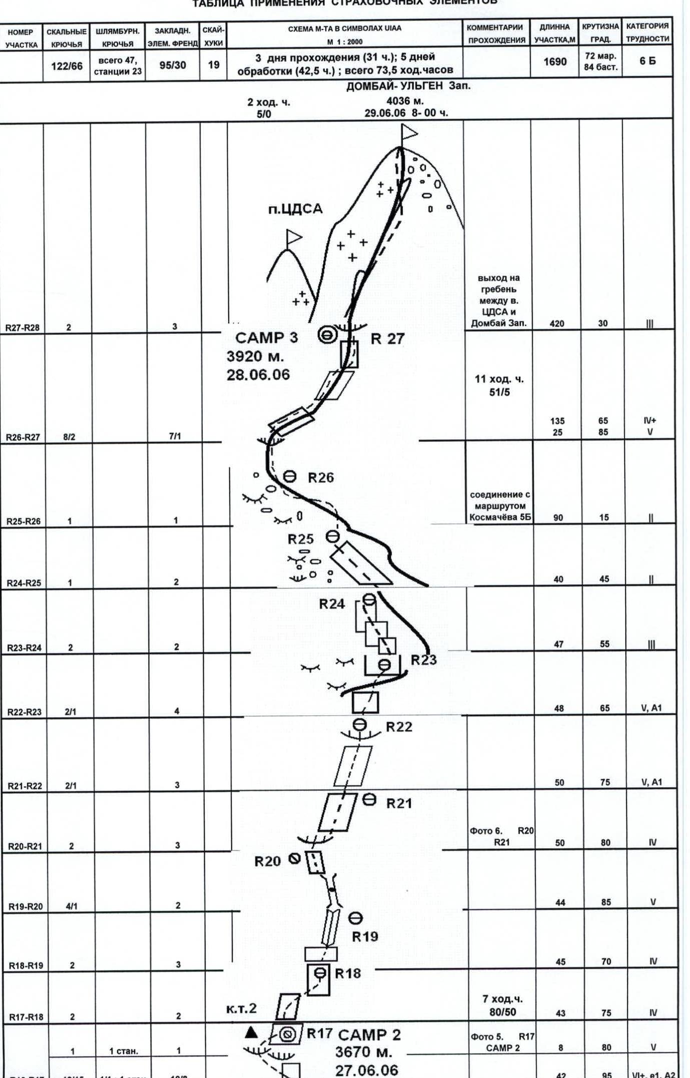
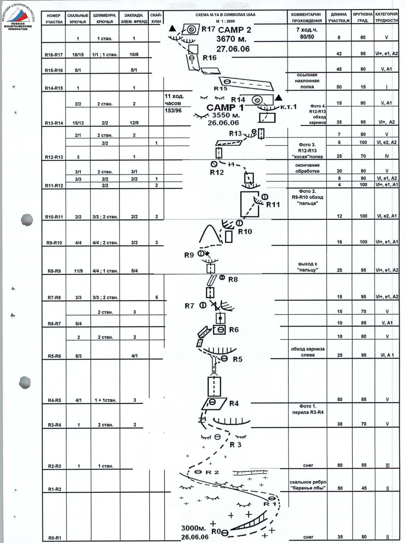
ROUTE SCHEME IN UIAA SYMBOLS
TABLE OF APPLICATION OF PROTECTION ELEMENTS
Peak Dombay-Ulgen Western, 4036 m. Length 1690 m. Climbing hours 73.5 h.
- Rock pitons: 122 (66)
- Bolted pitons total: 47 (23 stations)
- Chocks: 95 (30)
Description of the route by sections
safety assessment, recommendations
Approach to the route: descent to the south from the overnight stay on Dombay pass (3200 m) to the 2nd "claw" of the southern wall of the Dombay-Ulgen massif, sticking to the left part of the glacier and bypassing crevasses — 1 h.
- R0–R1: snowy slope, bypassing the bergschrund on the right, simultaneous movement on three paces;
- R1–R2: simple rocks and "ram's foreheads", crossed by inclined and horizontal shelves, simultaneous movement;
R2–R3: steep snowy slope, movement of the first on three paces, the rest on ropes; R3–R4: plate-like rocks, bypassing the cornice on the right, belay — pitons, medium stoppers, free climbing;
R4–R5: movement along plate-like rocks with free climbing; R5–R6: bypassing the cornice on the left, possible rockfall, difficulties with pulling the rope, descent and knocking out some intermediate points, straightening the ropes for subsequent movement;
R6–R7: start — on ITO (thin petals), movement to the left — live rocks, belay — pitons;
R7–R9: negative plates, very poor relief, use of relief and hole skyhooks, ladders, bolts;
R9–R11: a series of alternating plates and cornices going to the right:
- tense work on ITO;
- unreliable points of self-belaying;
- skyhooks;
- safe belay for the lower one.
R11–R12: passage of the cornice — exit to simple climbing, lack of visual control for the belayer;
R12–R13: after moving along a simple oblique shelf — exit under a very complex cornice, passed right-in-face, danger of ITO pulling out;
R13–R14: very tense movement on ITO, danger of rockfall, unreliability of belay points and danger of deep fall, special control of the belayer. In the second part of the section, there is no voice communication with the belayer. Exit to gentle plates and overnight stay. There are no platforms for a tent. Separate sitting overnight stays;
R15–R16: dangerous cornice in the middle of the section — climbing and ITO (piton); R16–R17: complex bypass of the cornice to the left, unreliable petals, it is necessary:
-
to remove intermediate points;
-
difficult pulling of the rope;
-
no voice communication;
-
it is desirable to straighten the ropes. The second overnight stay does not allow the installation of a tent, there are shelves for separate lying overnight stay, processing is recommended.
-
R18–R23: sections 4–5 category difficulty, free climbing, belay is normal, short sections of ITO, movement to the right — upwards in the direction of the ridge;
-
R23–R26: movement along the ridge in the direction of TsDSA peak;
-
R26–R27: movement along the counterfort of TsDSA peak, sections with rockfall, several cornices, climbing, several platforms for tents. Overnight stay on the ridge in stormy weather is not recommended.
-
R27: exit to the summit along the ridge of TsDSA peak — Dombay West, simultaneous movement, 2–4 category difficulty, on the way back several rappels.
Recommendations: The route is recommended for well-prepared groups with experience of several ascents of 6B category. The lack of good overnight stays on the lower part of the bastion involves processing or using hammocks. Lack of water throughout the route. 2 l / person / day is required. The absence of a "roof" and snow on it, as well as the strong steepness of the bastion, reduces the likelihood of rockfall. The group must have a full set of mountaineering equipment.
PHOTO 4. R13–R14 cornice, exit to overnight stay CAMP 1.
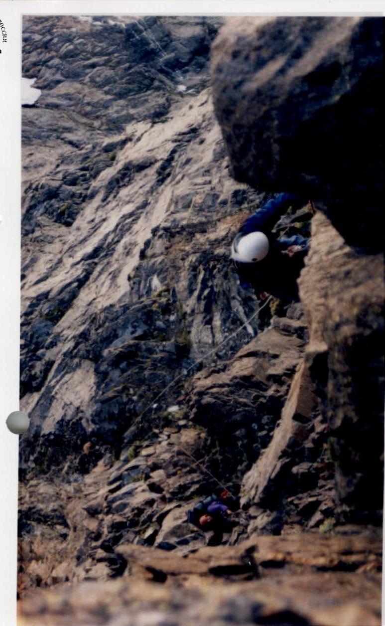
PHOTO 5. R14–R14 CAMP 1.
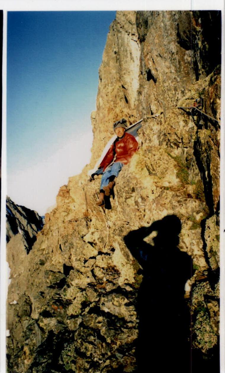
PHOTO 6. R20–R21 transportation of the haul bag.
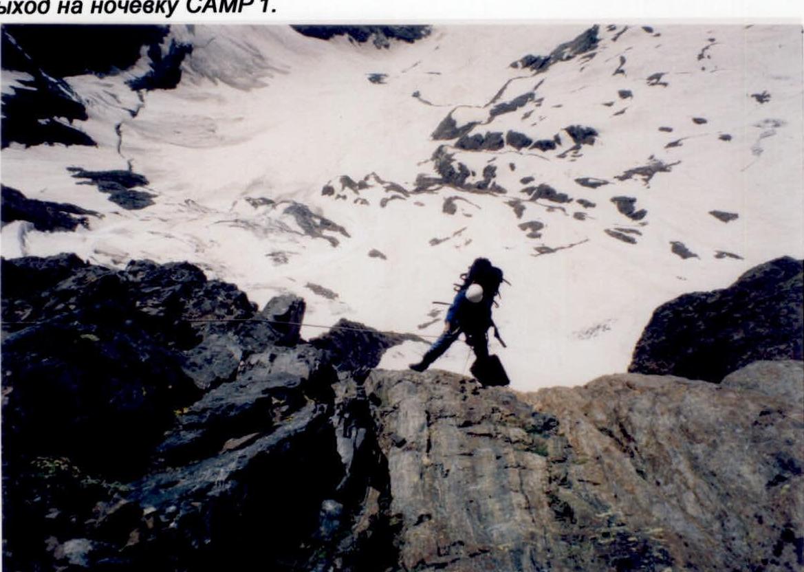

PHOTO 1. R3":{"width":787,"height":1109,"format":"Jpeg","uri":"https://summitx.info/media/1/LWLFi4hcH25EkMh4vqarIDUHH2bPZS5P/img-12.jpeg","id":64811261}↗)
PHOTO 2. R9–R10 bypass of the "finger".
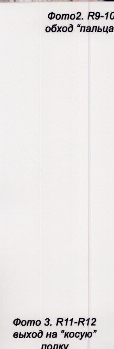
PHOTO 3. R11–R12 exit to the "oblique" shelf.