
Passport
- Caucasus, from Marukh pass to Nakhar pass, section 2.2.
- Dombai-Ulgen Western, via the bastion (bastion) of the southern wall.
- Proposed — 6A category of difficulty, first ascent.
- Route character: rock.
- Height difference: 1036 m.
Route length — 1450 m. Length of sections: 5th category of difficulty — 230 m, 6th category of difficulty — 130 m; Average steepness: main part of the route from the base of the wall to the ridge (excluding the talus hollow) — 72° (3070–3950). Total from the start of the route (“paw”) to the summit — 55° (3000–4036).
- Hooks left on the route: total — 4 pcs., including pitons — 0 pcs. Hooks used for belay (denominator — for artificial aid climbing): rock hooks — 70/27, pitons (removable) — 0/0, pitons (stationary) — 0/0, chockstones — 155/51.
- Team's climbing hours: 34 h and days — 4.
- Leader: Zagirnyak Mikhail Vasilyevich — Master of Sports; participants: Pugachev Sergey Alexandrovich — Master of Sports, Novak Igor Iosifovich — Candidate for Master of Sports, Novak Oksana Lvovna — Candidate for Master of Sports, Brodyanoi Sergey Grigoryevich — 1st sports category.
- Coach: Zagirnyak Mikhail Vasilyevich — 1st category, Master of Sports.
- Summit exit: August 9, 2000.
Summit — August 12, 2000; return — August 12, 1999
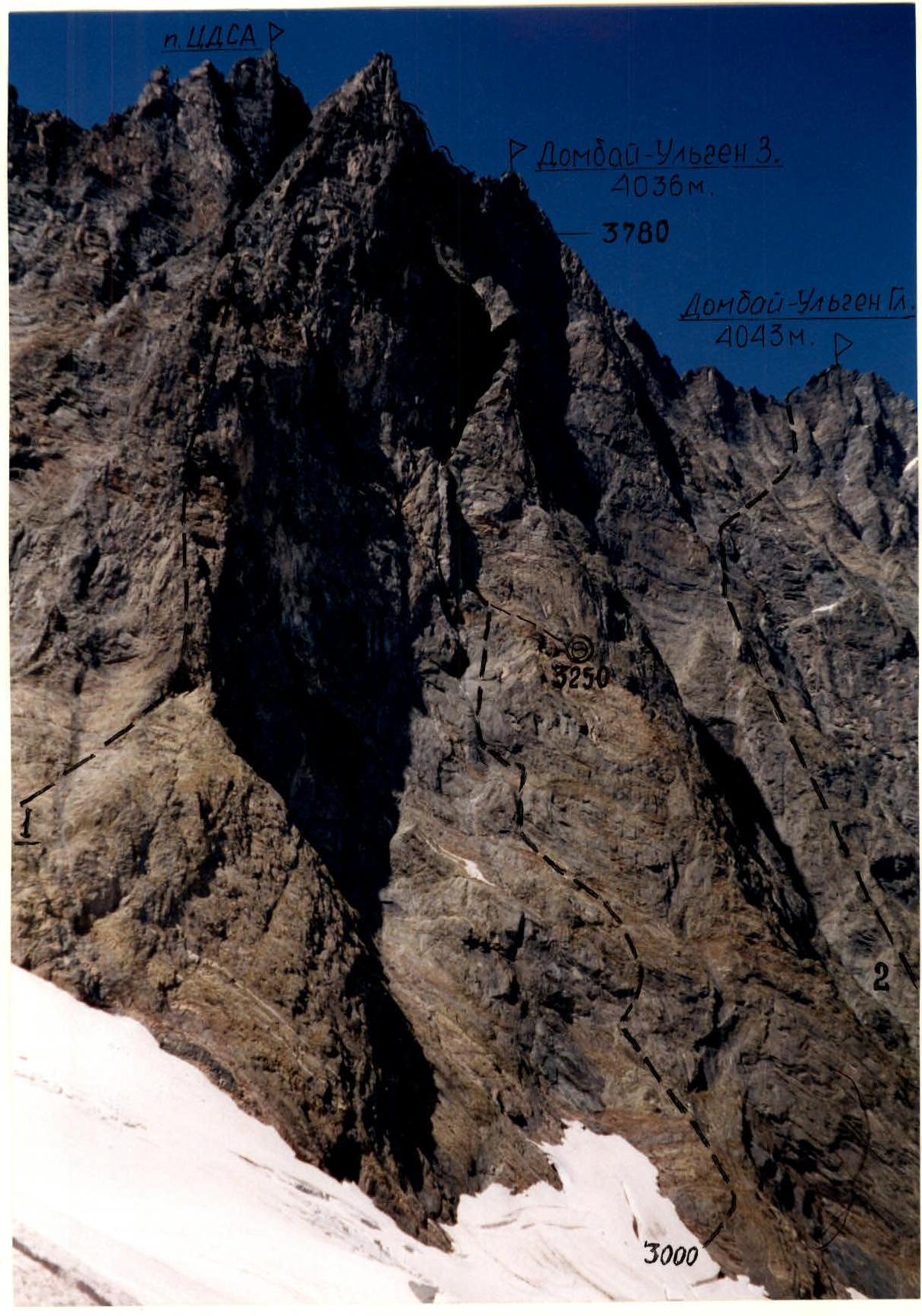
Photo 1. General photo of the summit. Taken from point A on the map-scheme on August 9, 2000, 16:00, distance 1000 m. Superzoom 800 lens, F=38 mm, height 3100 m.
- 1 — Dombay 3 via S wall by TsDSA, 5B, O. Kosmachev, 1960
- 2 — Dombay Main via S wall, 6A, V. Korotkov, 1973
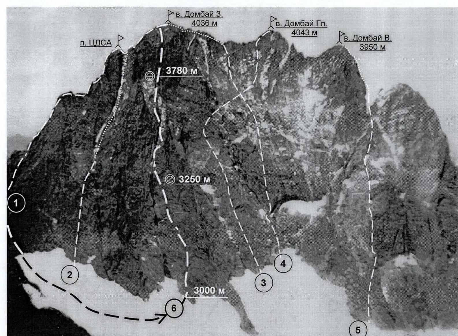
Photo 3. Photopanorama of the area. Taken from point B on the map-scheme of the area on August 1, 1991, distance 3 km, height 3300 m.
- 1 — Dombai-Western from Dombai pass, 5A, V. Nesterov, 1951
- 2 — Dombai-Western via southern wall of TsDSA peak, 5B, O. Kosmachev, 1960
- 3 — Dombai-Main via southern wall, 6A, V. Korotkov, 1973
- 4 — Dombai-Western via southern wall, 5B, I. Galustov, 1954
- 5 — Dombai-Eastern via southern wall, 5B, K. Kuzmin, 1948
- Dombai-Western via bastion of southern wall, proposed 6A, Zagirnyak, 2000 (N. Khubiev 1975)
Map-scheme of the ascent area
Scale 1:50000

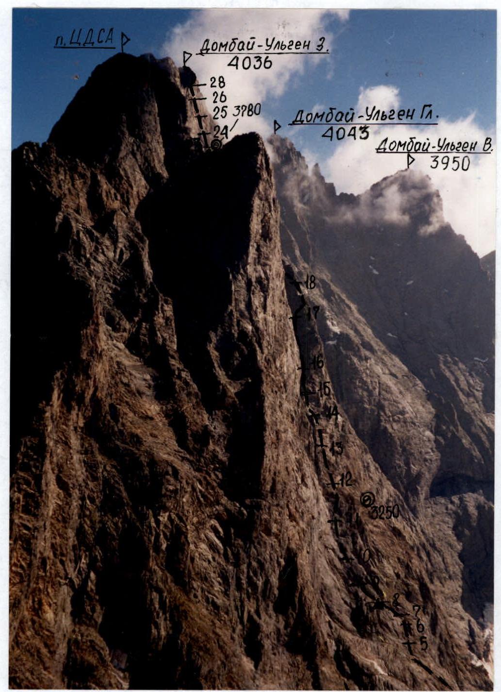
Photo 2. Profile of the wall on the left. Taken from point B on the map-scheme on August 7, 2000, 9:00, distance 700 m. Superzoom 800 lens, F=38 mm, height 3450 m.
Drawn profile of the route
Scale 1:4500
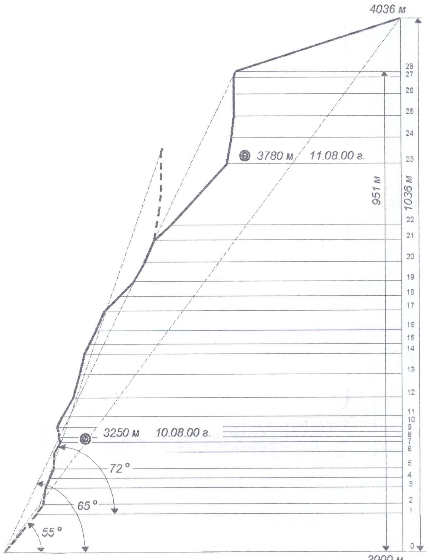
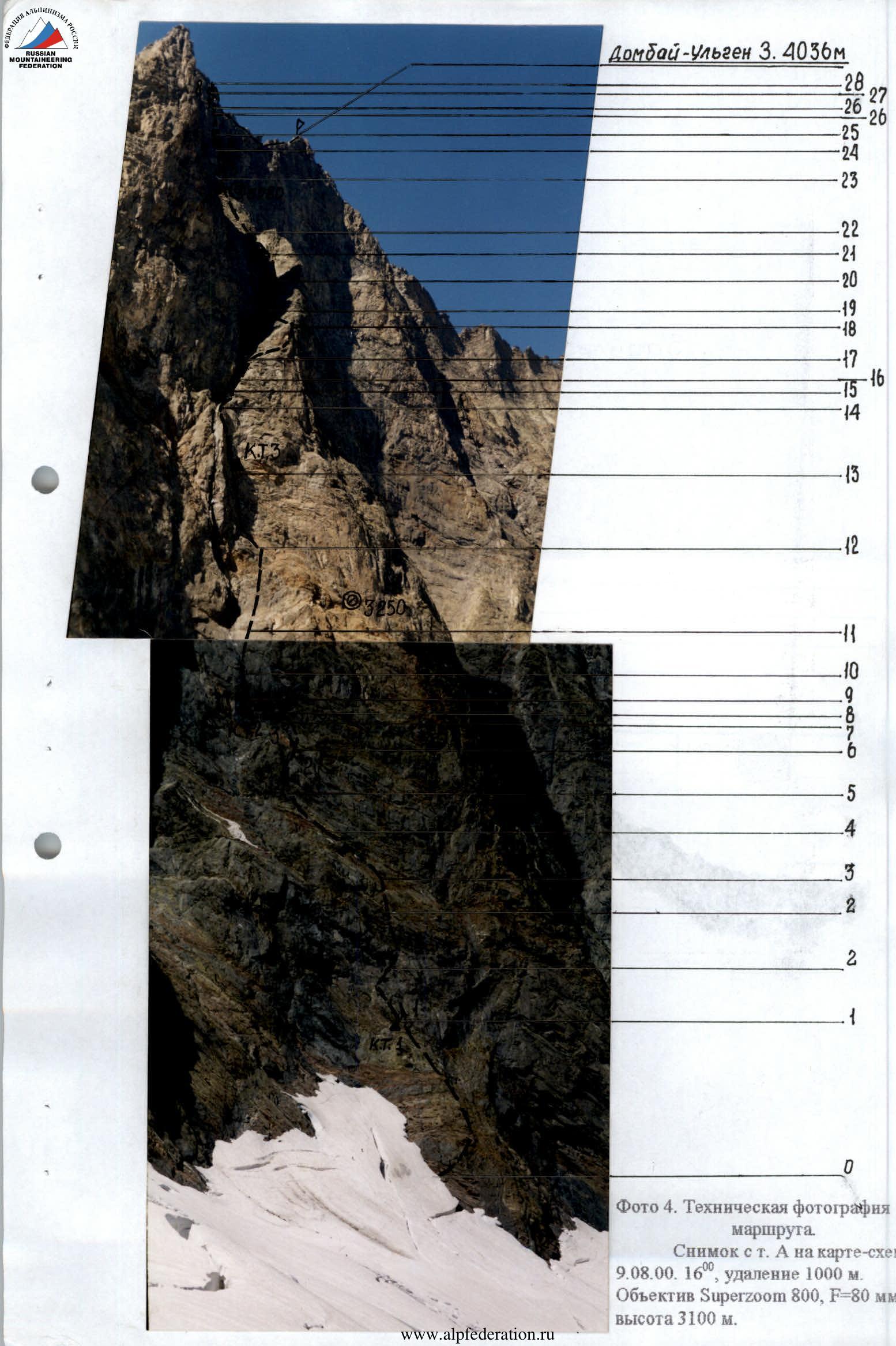
Photo 4. Technical photograph of the route. Taken from point A on the map-scheme on August 9, 2000, 16:00, distance 1000 m. Superzoom 800 lens, F=80 mm, height 3100 m.
Note from the summit
 www.alpfederation.ru ↗
 www.alpfederation.ru ↗
 www.alpfederation.ru ↗
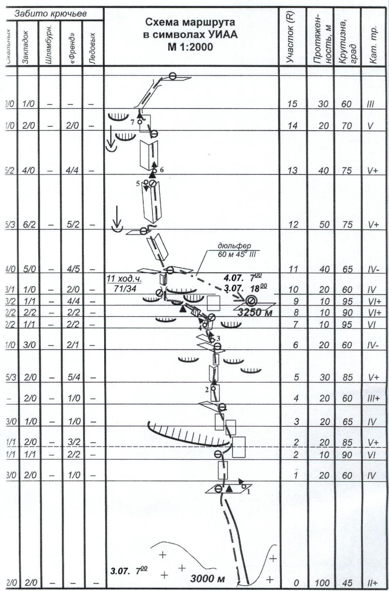
Approach to the route: descend south from the overnight stay on Dombai pass (3200 m) to the 2nd “paw” of the southern wall of the Dombai-Ulgen massif, following the left part of the glacier and avoiding crevasses — one hour.
- R0–R1: simple rocks and “ram's foreheads”, intersected by inclined and horizontal ledges, simultaneous movement.
- R1–R2: first, move 20 m left – up via medium-difficulty rocks to a crack on the wall, then via a difficult wall section under the right part of the “large cornice” crossing the bastion in the lower third. Belay with pitons.
- R2–R3 — the overhang in the right part of the cornice is overcome via a very difficult wall section about 10 m, then the rocks become easier until section R5. Here there are many convenient ledges for organizing belay points. Belay with pitons.
- R3–R5 — here it is worth going left, to the internal corner (see photo-illustration of the report), leading to the system of cornices.
- R5–R6 — very difficult internal corner with a small cornice in the middle part, f-rends and chockstones go well.
- R7–R8 — wide internal corner with a negative slope, passed with the help of artificial aid climbing.
- R8–R9 — crack in a sheer wall, going left – up under a cornice. Very complex climbing using all technical means.
- R9–R10 — wall with a negative slope and cornice. Climbing is extremely difficult, very few holds and cracks. Section is overcome with the help of artificial aid climbing.
- R10–R12: rocks of medium difficulty, belay with pitons, movement of the rope team is autonomous. On section R11, a wide inclined ledge goes right – down (about 60 m), where a small platform is built in its lower part, and two separate lying places. At the end of the section, water flows down the wall; you can replenish its supplies.
- R12–R13: difficult internal corner, many “live” holds, belay via f-rends and chockstones, passed in the upper part with artificial aid climbing. At the base of the next internal corner — an uncomfortable station.
- R13–R14 — internal corner, passed along the smoothed right side, very complex climbing (artificial aid climbing, ladders).
- R14–R15 — steep smoothed wall, climbing is difficult, overcome by free climbing with belay on chockstones and pitons.
R15–R21 — long chimney-like section, climbing from simple to above average, belay via pitons and chockstones, the chimney is shot with stones! On section R17, there is a small snow patch — the last place on the route where you can stock up on water.
R21–R23 — in the upper part, the chimney turns into a couloir, leading to a wide talus hollow under the southern wall of the western ridge of the summit. At the very base of the wall, a good horizontal platform is built for an overnight stay.
R23–R24 — five meters to the left of the platform — a ten-meter steep internal corner, climbing is tense, rocks are destroyed. Further movement is to the right, around the overhang on the destroyed wall, straight – up via difficult rocks to an inclined ledge. There are many cracks on the section, but it is very difficult to hammer in a hook — destroyed microrelief. (Sections R23–R28 are illustrated with photographs).
List of sections:
- R23
- R28
(Sections R23 and R28 are illustrated with photographs).
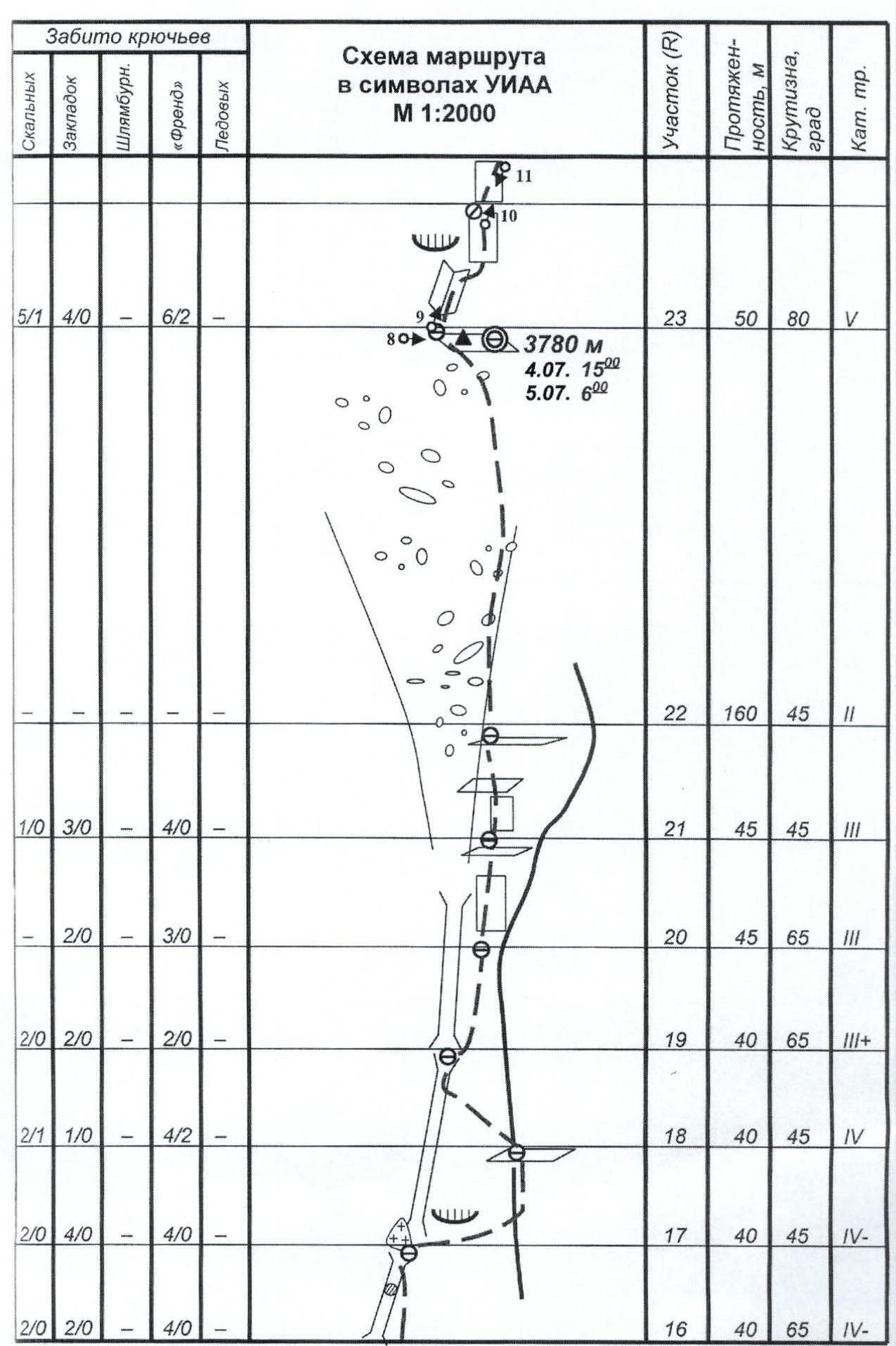
R23–R25 — from the station on the ledge, movement is to the right and up via very difficult walls, climbing, starting from the second quarter of the section, is extremely complex (artificial aid climbing). In addition, from this section and almost to the ridge, the wall is shot with stones. At the end of the section — a very uncomfortable hanging station.
R25–R26 — sheer monolithic smooth wall with a limited number of micro-holds, passed on ladders and hook-nogs with the help of skyhooks.
At the top of the section:
- Very complex vertical internal corner
F-rends go well.
R26–R27 — ten-meter internal corner with a negative slope, overcome with the help of ladders, leads to a difficult smoothed wall, passed by free climbing. Belay is mainly via chockstones.
R27–R28 — small internal corner, turning into a short wall, above medium difficulty, leading to a gap in the summit ridge. Section is passed by free climbing with belay on chockstones.
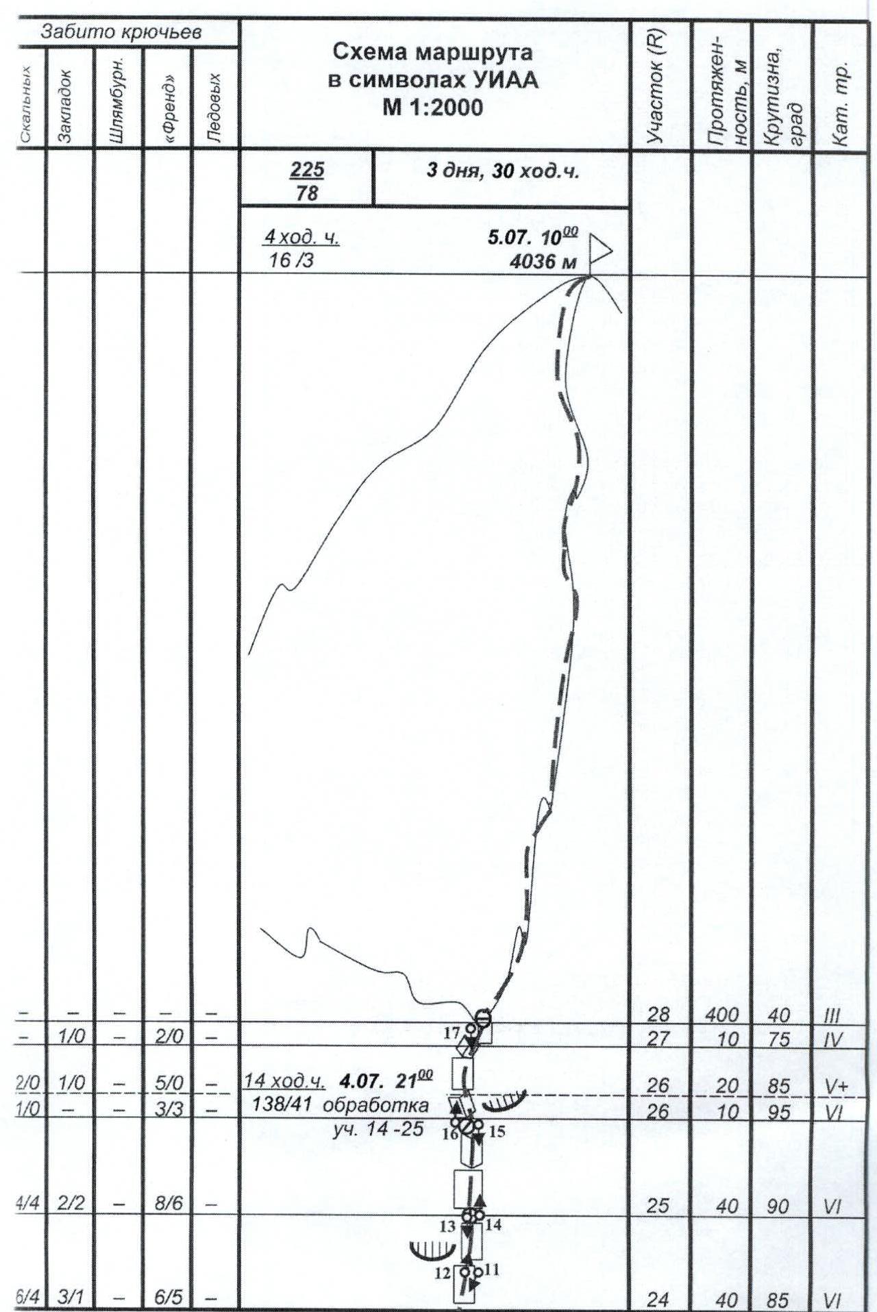
R28–summit — summit ridge. Simultaneous movement.
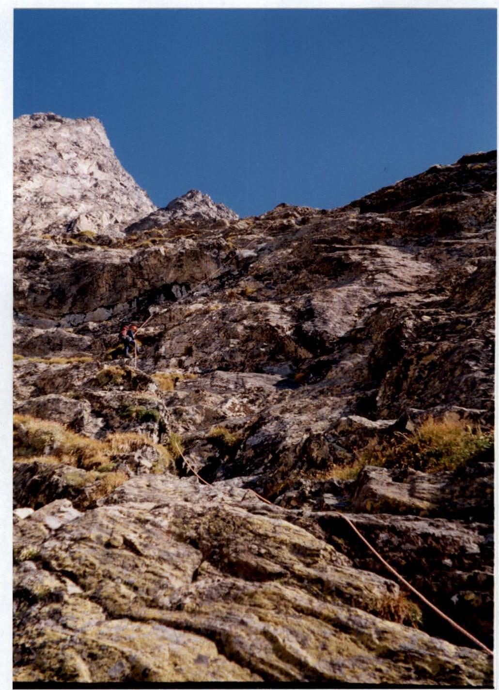
Photo 5. Section R1–R3. Taken from point 1 on the UIAA scheme and technical photograph on August 10, 2000, 10:00, distance 20 m. Superzoom 800 lens, F=38 mm, height 3070 m.

Photo 6. Section R6–R10. Taken from point 2 on the UIAA scheme and technical photograph on August 10, 2000, 12:30, distance 20 m. Superzoom 800 lens, F=50 mm, height 3150 m.
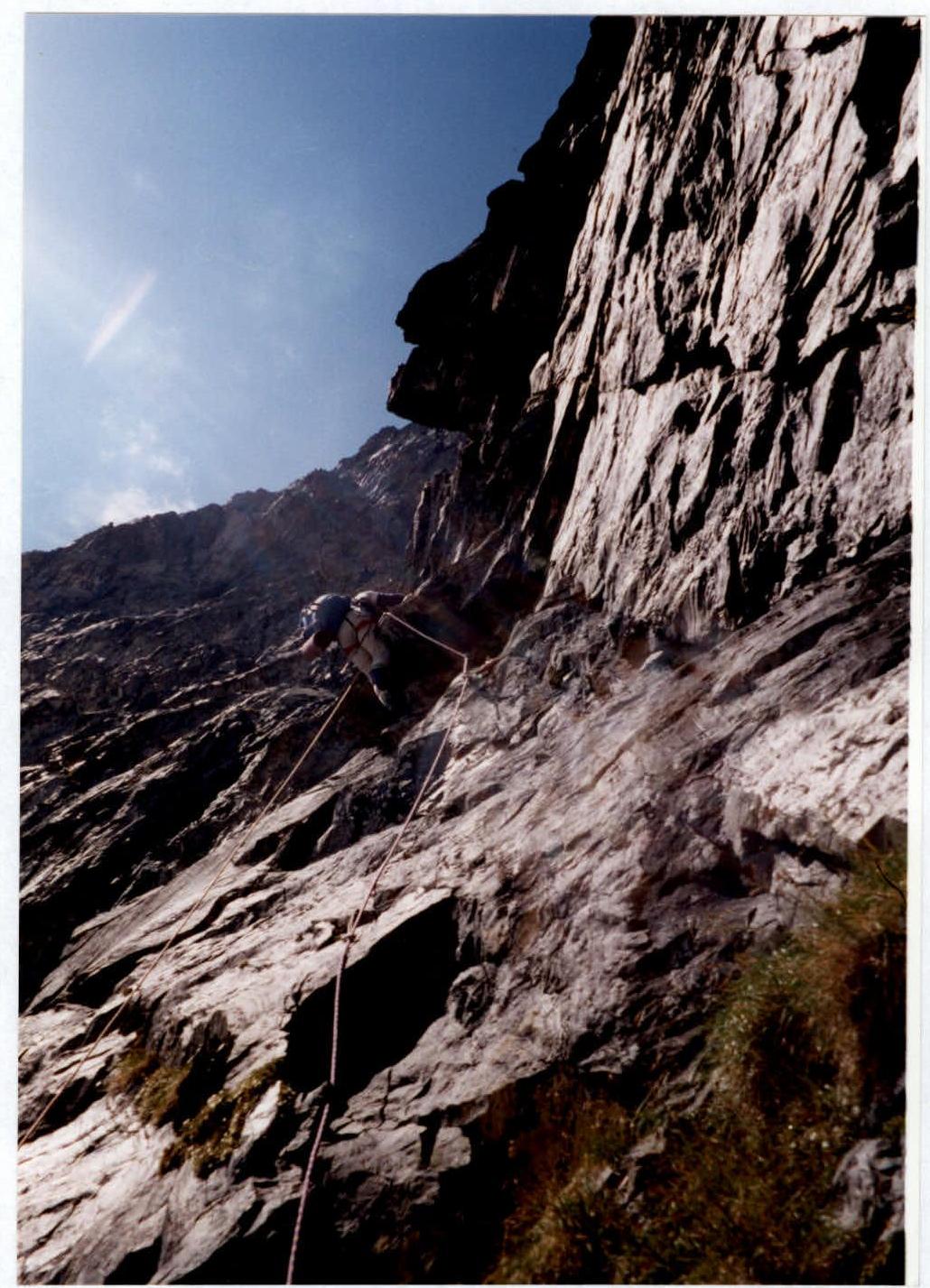
Photo 7. Section R7–R9. Taken from point 3 on the UIAA scheme and technical photograph on August 10, 2000, 14:00, distance 10 m. Superzoom 800 lens, F=50 mm, height 3170 m.
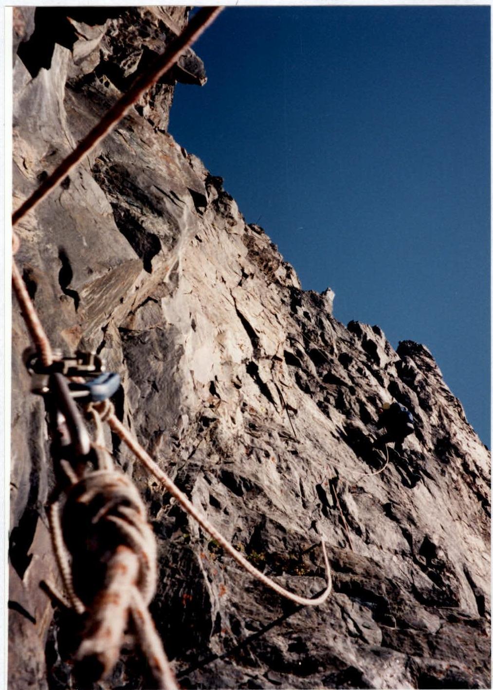
Photo 9. Section R24–R25. Taken from point 5 on the UIAA scheme and technical photograph on August 12, 2000, 7:30, distance 1 m. Superzoom 800 lens, F=38 mm, height 3830 m.
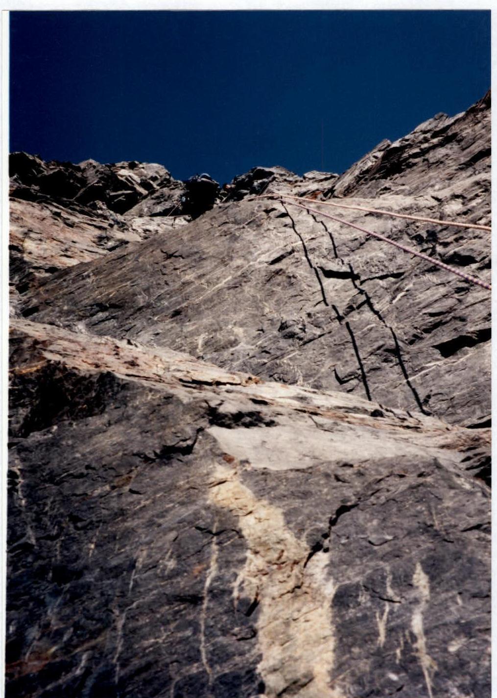
Photo 10. Section R25–R26. The first half of the section — smoothed slabs with a small number of holds. Taken from point 6 on the UIAA scheme and technical photograph on August 12, 2000, 8:30, distance 3 m. Superzoom 800 lens, F=38 mm, height 3870 m.

Photo 12. Section R26–R27. Taken from point 8 on the UIAA scheme and technical photograph on August 12, 2000, 11:00, distance 1 m. Superzoom 800 lens, F=38 mm, height 3930 m.
Dear colleagues!
Having, thanks to V.N. Shataev, the opportunity to carefully study the reports on first ascents to Dombai-Ulgen Western peak, made from the southern cirque by teams:
- team led by A.A. Abramov (1961)
- team led by V.N. Shataev (1963)
- team led by V.G. Terekhin (1965)
- team led by V.N. Shataev (1966)
- team led by V.N. Shataev (1967)
- team led by V.N. Shataev (1968)
- team led by V.N. Shataev (1969)
- team led by V.N. Shataev (1970)
- team led by V.N. Shataev (1971)
- team led by V.N. Shataev (1972)
- team led by V.N. Shataev (1973)
- team led by V.N. Shataev (1974)
- team led by V.N. Shataev (1975)
- team led by V.N. Shataev (1976)
- team led by V.N. Shataev (1977)
- team led by V.N. Shataev (1978)
- team led by V.N. Shataev (1979)
- team led by V.N. Shataev (1980)
- team led by V.N. Shataev (1981)
- team led by V.N. Shataev (1982)
- team led by V.N. Shataev (1983)
- team led by V.N. Shataev (1984)
- team led by V.N. Shataev (1985)
- team led by V.N. Shataev (1986)
- team led by V.N. Shataev (1987)
- team led by V.N. Shataev (1988)
- team led by V.N. Shataev (1989)
- team led by V.N. Shataev (1990)
- team led by V.N. Shataev (1991)
- team led by V.N. Shataev (1992)
- team led by V.N. Shataev (1993)
- team led by V.N. Shataev (1994)
- team led by V.N. Shataev (1995)
- team led by V.N. Shataev (1996)
- team led by V.N. Shataev (1997)
- team led by V.N. Shataev (1998)
- team led by V.N. Shataev (1999)
- team led by V.N. Shataev (2000)
- N.M. Khubieva (August 7–11, 1975) from the south via the green counterfort;
- M.V. Zagirnyak (August 9–12, 2000) via the bastion of the southern wall; second ascent with the participation of the same duo M. Zagirnyak – S. Pugachev (July 3–5, 2005);
- R.Yu. Gubanov (June 13–20, 2004) via the counterfort of the southern wall;
- S.A. Pugachev (June 26–30, 2006) via the centre of the triangle of the southern wall we again request that the changes, clarifications set out in Information No. 1–4 and later in Information No. 1–6 be reconsidered.
Recall that in the table “Classification of routes to mountain peaks”, 2001, section 2.2, p. 83 — Dombai (3) it was: 6A category of difficulty, bastion of S. wall, M. Zagirnyak, 2000; became: 5B, N. Khubiev, 1975 (see Information No. 1–4 and No. 1–6). In Information No. 5, another route was added to this section of the table under the same number 83: 5B category of difficulty, counterfort of S. wall, R. Gubanov, 2004.
Before proceeding to the analysis of the teams' reports, I would like to familiarize the commission with my experience in exploring the Dombai massif from the south.
Let's leave the history of ascents from the south to Dombai in the mid-seventies, when MS L. Volkov and I first assessed the southern walls, and especially TsDSA peak.
1998 (July) — work at the Lugansk gatherings, inspection of the West Dombai wall from the south, possible first ascents are planned. Ascent with разрядники on Main Dombai via Korotkov's route. Due to bad weather, we retreat directly to the ridge of West Dombai two ropes below the ridge between TsDSA peak and West Dombai, accidentally discovering a suspended gas cylinder. Unfortunately, we couldn't read the note inside. The route was not completed, but we walked along the wall.
1999 (July–August) — South Dombai, 3A category of difficulty, in a duo with MS V. Solovyov. Photographing the bastion of the southern wall of TsDSA peak, etc. Ascent with разрядники on West Dombai from the pass, 5A category of difficulty. Inspection of the southern walls from above.
Ascent to Main Dombai via V. Korotkov's route, 6A category of difficulty. Crossing the clearly defined “paw”, from which the counterfort begins (N. Khubiev's and R. Gubanov's route). On this “paw” — old habitual overnight stays (obviously at the level of the first overnight stay on R. Gubanov's route) and a “sports” descent to the glacier for the approach under V. Korotkov's route.
2000 (August) — South Dombai, 3A category of difficulty, in a duo with MS S. Pugachev. Photographing the profile, descent to the South cirque and photographing the walls from the South cirque.
2001 (July–August). In a duo with MS S. Pugachev, we “probed” a new route via the centre of the wall on TsDSA peak. Then we climbed O. Kosmachev's route via the S wall of TsDSA peak to West Dombai in one day, 5B category of difficulty.
2003 (late August). In a duo with MS S. Pugachev, due to bad weather and lack of time, we took V. Korotkov's route, 6A category of difficulty. Sergey had not climbed it before. Again through the same “paw” — the beginning of the counterfort. Senior instructor of the Dombai PPS MES Russia E. Sorokin observed our counterfort “paw”.
2005 (July). An attempt to climb the bastion of TsDSA peak was unsuccessful (participants' illness, lack of pitons). We repeated our route via the southern wall of the bastion. It was necessary to remove suspicions about the route's rockfall danger, which were discussed in the area at that time.
2006 (June) — our group climbed a new route (S. Pugachev) on the bastion of TsDSA peak (6A category of difficulty).
As can be seen from this simple list, the author of these lines and his partners have sufficiently examined and explored the Dombai massif from the south. Note that all ascents were registered at the Dombai PPS MES Russia and there are original notes from all control tours, both fresh and many years old, which is not always the case now (groups from Moscow — N.V. Vakula, Irkutsk — Krivosheev, Maikop, etc.). Many of the ascents were made under the direct observation of MES employees (E. Sorokin and R. Gubanov).
I would like to note that throughout this time, there was no information from any sources about the existence of N. Khubiev's route, neither to us nor to those who constantly make ascents in the Dombai region. I mean, first of all, R. Gubanov and other rescue-climbers.
Now about the routes themselves.
Having carefully studied the reports, we came to the conclusion that the identification of the routes can be mainly shown based on the consideration of four photos (attached). One from N. Khubiev's report (Photo 1) and R. Gubanov's report (Photo 3). In these reports, in addition to the ones under consideration, the other photos are photos of sections. And two photos from our team's report on the ascent via the bastion of the southern wall: a photo from the passport (Photo 2) and a photopanorama of the Dombai massif from the south (Photo 4).
On each of these photos, we plotted the missing routes based on the analysis of all information and our experience of ascents to have a clearer picture of their relative positions. Of course, the original photos were used as a basis, and the routes plotted on them by the authors were not corrected.
We draw the attention of the commission members to the fact that the names of N. Khubiev's route and R. Gubanov's route, assigned by the teams independently of each other, contain the term “via the counterfort”, and both start on a large, clearly defined “paw”, as can be seen from Photo 1 and Photo 3.
Thus, in the lower part (with a height difference of about 300 m), we can speak of a coincidence between N. Khubiev's and R. Gubanov's routes.
In 2005, when repeating our route, we saw their hook with a loop for descent on the first key section.
According to the reports, the second overnight stay on R. Gubanov's route and the first overnight stays on our team's route and N. Khubiev's route were approximately at the same level, where the massif under the bastion of TsDSA peak to the counterfort is intersected by a not clearly defined ledge, turning into a slit towards the counterfort. But we specifically traversed (60 m) to the right and descended via a rappel, as can be seen from Photo 2 and our UIAA scheme.
Further, R. Gubanov's route continues along the counterfort, exiting onto a ridge to the right of the chimney-couloir. Our team's route also leads to this ridge. N. Khubiev's team, judging by Photo 1 and their description, exited to a stream at the base of the chimney-couloir between our team's route and R. Gubanov's team via the slit-crack and internal corner there. We stuck to the wall. Then our route coincides with N. Khubiev's route for no more than three ropes, possibly two. Since due to rockfall danger (especially during the second ascent), we were forced to exit via the wall onto the ridge and move along it to the hollow under the tower of the ridge. The same route was later taken by Gubanov's team. This section is evaluated by the teams at the level of III+ and IV+ category of difficulty, regardless of the movement options, and is not key.
Movement along the hollow (about 300 m, third category of difficulty) is not particularly difficult, and how the teams passed it is also not принципиально.
But then the teams passed the tower-bastion of the ridge in fundamentally different ways. It should be noted that the hollow is divided by a not clearly defined ridge-bend, which is a continuation of the counterfort and leads to the edge on the tower-bastion of the main ridge of the West Dombai massif. The left wall of the edge, more sheer, faces directly the part of the hollow into which the chimney-couloir leads. The right wall faces the huge hollow of the entire massif from West Dombai to Main Dombai. Galustov's route exits onto the ridge along it, and along it, as mentioned above, in July 1998, we exited onto the ridge and found a gas cylinder with a note. Now we can assume that it was left by N. Khubiev's group.
Our route goes практически vertically upwards, first along an internal corner (“R23–R24 five meters to the left of the platform — a ten-meter steep internal corner, climbing is tense, rocks are destroyed”), and then along a system of walls. We specifically hung a control tour there.
At the same time, both N. Khubiev's team and R. Gubanov's team switched to the right wall of the bastion. Corresponding entries can be found in N. Khubiev's report (Section 5 ...“then it goes to the right side of the tower”) and R. Gubanov's report (“R14–R15 the right edge of the hollow leads under the wall, a little descent to the right behind the bend and up to the right via a system of walls”). In addition, the rightward movement is shown on the UIAA scheme presented in R. Gubanov's report above their fourth overnight stay; to the left of the overnight stay, a vertical internal corner is also clearly drawn.
Therefore, one of the sections (on our route, about 200 m, 6th category of difficulty), marked by all teams as key, was passed by our team via a different path.
Unfortunately, the tower-bastion is obscured in the photos, and it is impossible to show this.
Thus, in the lower part (about 300 m), N. Khubiev's and R. Gubanov's routes coincide. In the chimney-couloir, N. Khubiev's and M. Zagirnyak's routes coincide (about 150 m). On the ridge to the right of the chimney-couloir, M. Zagirnyak's and R. Gubanov's routes coincide (about 200 m, III–IV category of difficulty). The passage of the hollow has already been discussed. On the tower-bastion, our route goes to the left of N. Khubiev's and R. Gubanov's routes, along a different wall of the bastion.
As a result, all the key (sixth and “five plus”) sections of our route do not совпадают with N. Khubiev's route, nor with R. Gubanov's route. There are control tours on them. We dare to note also that the majority of these sections could not have been passed in 1975 by N. Khubiev's group with the equipment indicated, the number of pitons on the sections, and within the specified time. Our colleagues simply climbed their route (and that is why we did not find any traces on the route). L. Volkov and I also have experience with fifth-category ascents in the mid-seventies, but we simply chose routes differently back then (closer to the relief).
In our opinion, the above and photographic materials are sufficient for making an informed decision. We believe that the original decision of the FCR Classification Commission regarding the category of difficulty (6A) and the independence of our route was correct and should be reinstated.
Sincerely, First Vice-President of the Alpine and Rock Climbing Federation of Ukraine
February 9, 2008
M. Zagirnyak
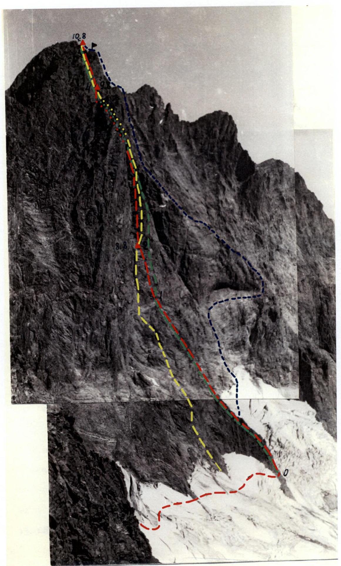
Photo 1. From N. Khubiev's report, routes:
- Dombai-Western via bastion of southern wall, 6A, M. Zagirnyak, 2000 (added, yellow)
- Dombai-Western via counterfort of southern wall, 5B, R. Gubanov, 2004 (added, green)
- Dombai-Western from south via green counterfort, 5B, N. Khubiev, 1975 (original, red)
- Dombai-Western via southern wall, 5B, I. Galustov, 1954 (original, blue)

Photo 2. From M. Zagirnyak's report, routes:
- Dombai-Western via southern wall of TsDSA peak, 5B, O. Kosmachev, 1960 (original, 1)
- Dombai-Main via southern wall, 6A, V. Korotkov, 1973 (original, 2)
- Dombai-Western via counterfort of southern wall, 5B, R. Gubanov, 2004 (added, yellow)
- Dombai-Western from south via green counterfort, 5B, N. Khubiev, 1975 (added, red)
- Dombai-Western via bastion of southern wall, 6A, M. Zagirnyak, 2000 (original, black)
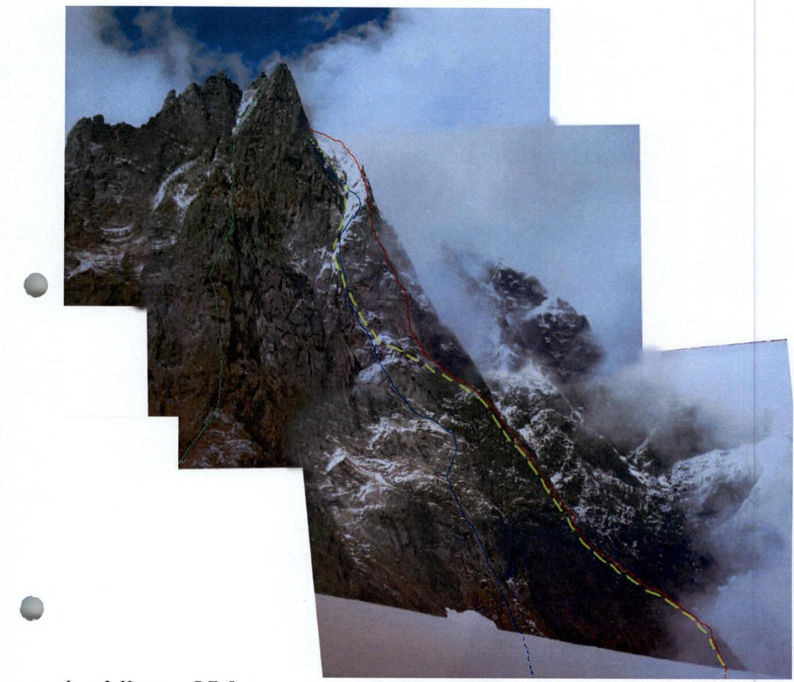
Photo 3. From R. Gubanov's report, routes:
- Dombai-Western via bastion of southern wall, 6A, M. Zagirnyak, 2000 (original, blue)
- Dombai-Western from south via green counterfort, 5B, N. Khubiev, 1975 (added, yellow)
- Dombai-Western via counterfort of southern wall, 5B, R. Gubanov, 2004 (original, red)
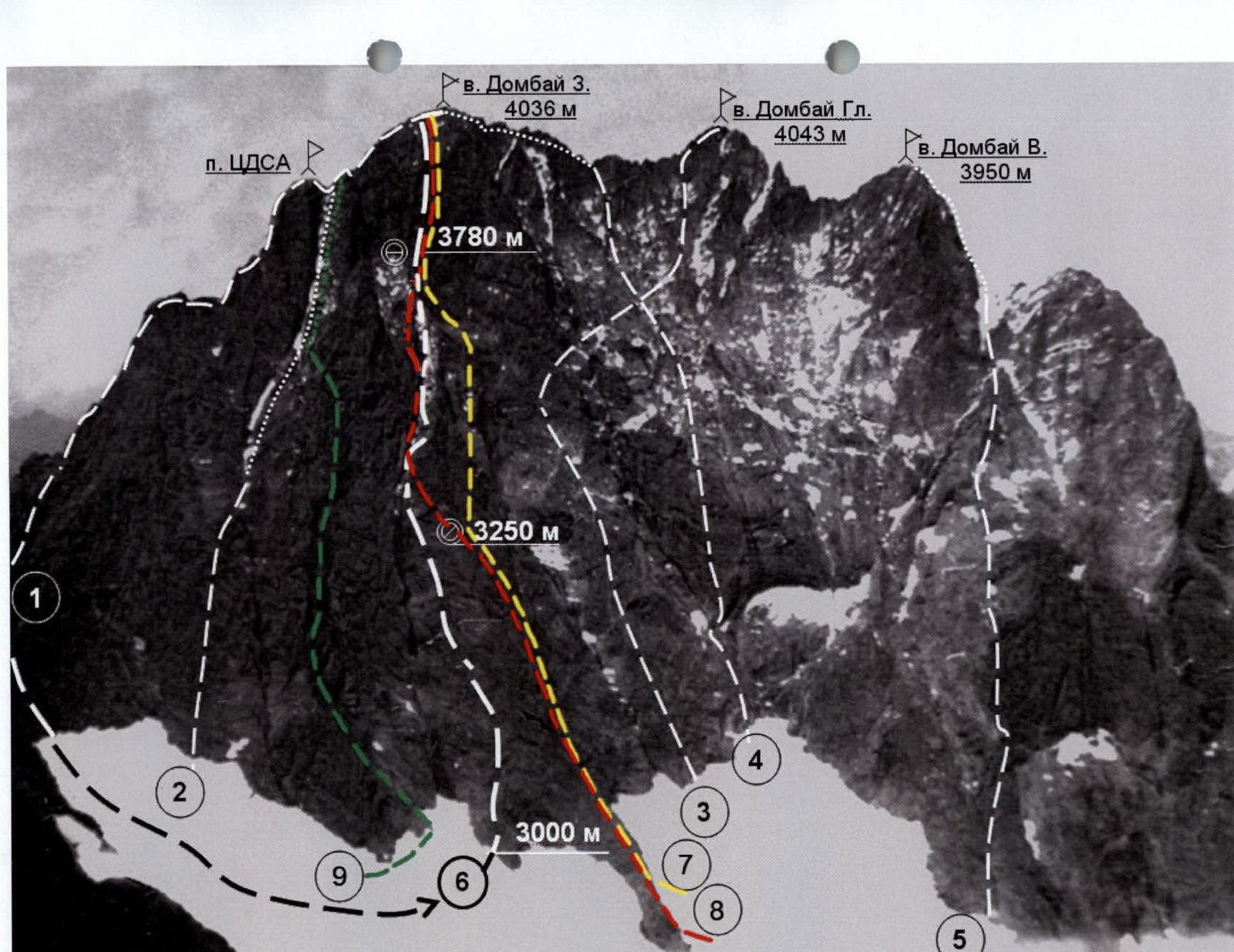
Photo 4. Photopanorama of the area. Taken from point B on the map-scheme of the area on August 1, 1991, distance 3 km, height 3300 m (routes 7 and 8 are added, the rest are original)
- 1 — Dombai-Western from Dombai pass, 5A, V. Nesterov, 1951
- 2 — Dombai-Western via southern wall of TsDSA peak, 5B, O. Kosmachev, 1960
- 3 — Dombai-Main via southern wall, 6A, V. Korotkov, 1973
- 4 — Dombai-Western via southern wall, 5B, I. Galustov, 1954
- 5 — Dombai-Eastern via southern wall, 5B, K. Kuzmin, 1948
- 6 — Dombai-Western via bastion of southern wall, 6A, M. Zagirnyak, 2000
- 7 — Dombai-Western via counterfort of southern wall, 5B, R. Gubanov, 2004 (yellow)
- 8 — Dombai-Western from south via green counterfort, 5B, N. Khubiev, 1975 (red)
- 9 — Dombai-Western via centre of triangle of southern wall, 6A, S. Pugachev, 2006 (green)
Comments
Sign in to leave a comment