
Ascent Passport
-
Russia, Caucasus.
-
Rock class.
-
Western Caucasus, from Marukh pass to Nakhar pass, section 2.2.
-
Peak Dombai-Ulgen Western (4036 m), via the bastion of the southern wall.
-
6A category of difficulty, second ascent.
-
Route characteristics:
height difference: 1036 m, length – 1450 m; length of sections 5–6 category of difficulty – 360 m; average steepness of the main part of the route: base of the wall — ridge (excluding talus) – 72° (3070–3950); start of the route (“claw”) — summit – 55° (3000–4036).
-
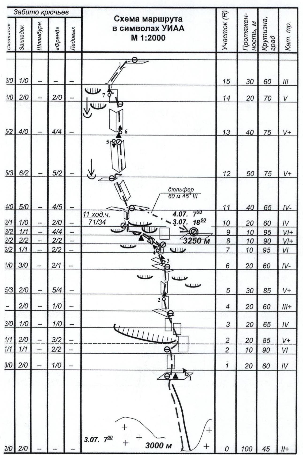
Pitons hammered (including in the denominator for IT):
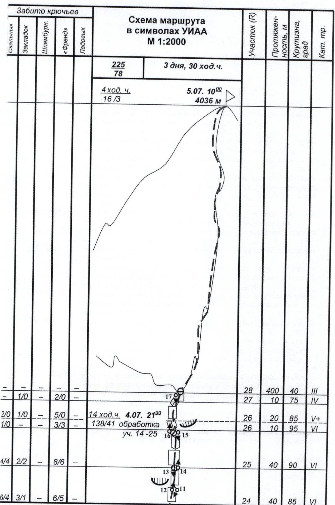
rock 70/27, ice 0/0, bolt 0/0, anchor 155/51
-
Climbing hours 29 hours and days – 3.
-
Number of overnight stays and their characteristics:
0 at the pass, comfortable in a tent; 1st — three in a tent on a sloping platform, two on shelves; 2nd — three in a tent on a comfortable platform, two on shelves.
-
Team leader: Pugachev Sergey Alexandrovich – MS; (Lugansk)
participants:
- Zagirnyak Mikhail Vasilievich – MS; (Lugansk)
- Volkov Leonid Borisovich – MS; (Kharkov)
- Grafov Evgeny Borisovich — MS; (Lviv)
- Larionov Alexey Vasilievich — MS. (Kharkov)
-
Team coach: Zagirnyak Mikhail Vasilievich – MS, instructor-methodologist category I.
-
Departure to the route: July 3, 2005;
summit – July 5, 2005, 10:00; return – July 5, 2005.
-
Organization — Lugansk Regional Federation of Alpinism.
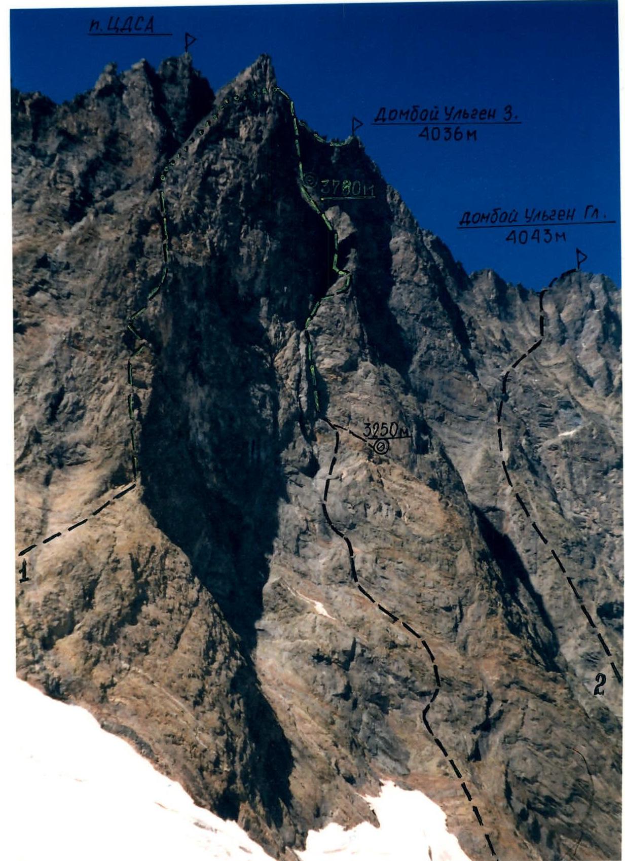
Photo 1. General photo of the summit. Shot from point A on the map-scheme 9.08.00. 16:00, distance 1000 m. Lens Superzoom 800, F=38 mm, height 3100 m.
- 1 — Dombai W via S wall route CDSА, 5B, O.Kosmachеv, 1960
- 2 — Dombai Main via S wall, 6A, V.Korotkov, 1973
- 3 — Dombai W via bastion of S wall, M.Zagirnyak, 2000
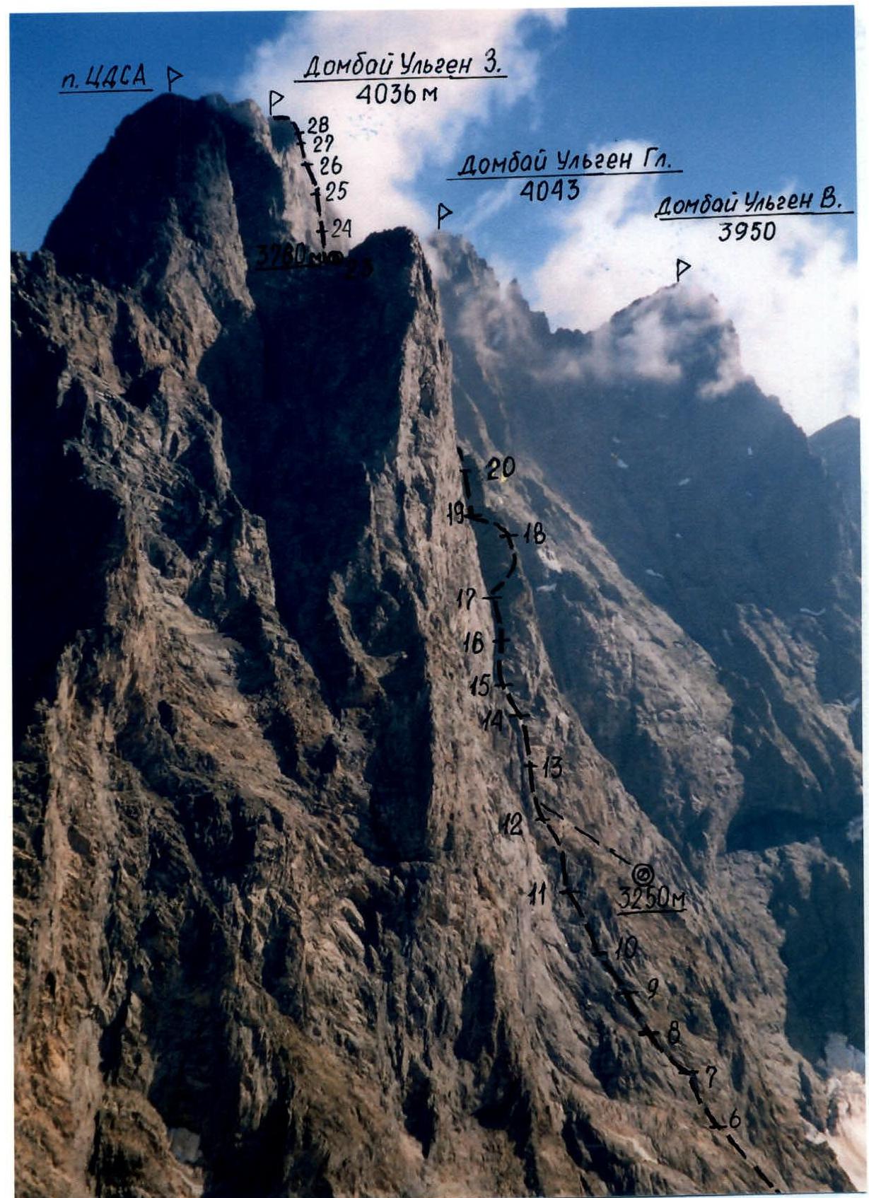
Photo 2. Profile of the wall on the left. Shot from point B on the map-scheme 7.08.00. 9:00, distance 700 m. Lens Superzoom 800, F=38 mm, height 3450 m.
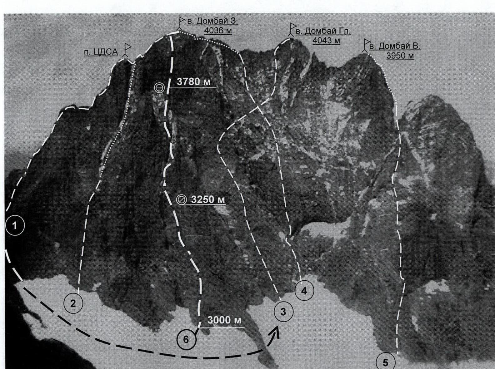
Photo 3. Photopanorama of the area. Shot from point C on the map-scheme of the area August 1, 1991, distance 3 km, height 3300 m.
1 — Dombai Western via Dombai pass, 5A, V.Nesterov, 1951; 2 — Dombai Western via southern wall of peak CDSА, 5B, O.Kosmachеv, 1960; 3 — Dombai Main via southern wall, 6A, V.Korotkov, 1973; 4 — Dombai Western via southern wall, 5B, I.Galustov, 1954; 5 — Dombai Eastern via southern wall, 5B, K.Kuzmin, 1948; 6 — Dombai Western via bastion of southern wall, 6A, Zagirnyak, 2000
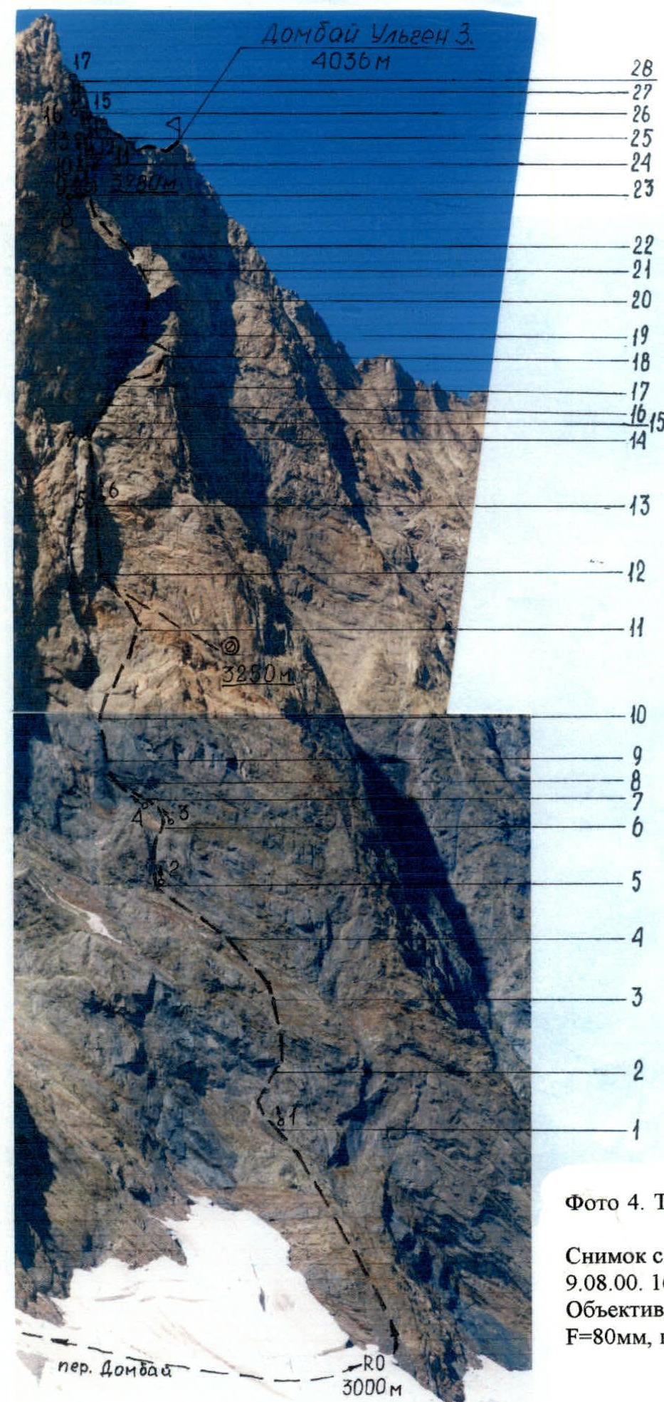
Photo 4. Technical photograph of the route. Shot from point A on the map-scheme 9.08.00. 16:00, distance 1000 m. Lens Superzoom 800, F=80 mm, height 3100 m.
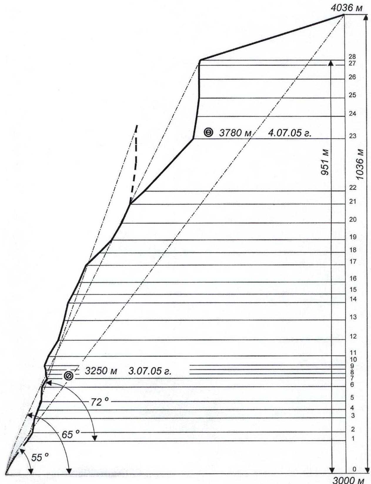
Drawn profile of the route M 1:4500

Route description by sections
Approach to the route: descent to the south from the overnight stay at Dombai pass (3200 m) to the 2nd “claw” of the southern wall of the Dombai-Ulgen massif, sticking to the left part of the glacier and avoiding crevasses — one hour.
R0–R1 — simple rocks and “ram’s foreheads”, intersected by inclined and horizontal shelves, simultaneous movement.
R1–R2 — first, move 20 m left — up through moderately difficult rocks to a crack on the wall, then through a difficult wall to the right part of the “big cornice” that crosses the bastion in the lower third. Rope protection is piton.
R2–R3 — the overhang in the right part of the cornice is overcome through a very difficult wall about 10 m, then the rocks become easier until section R5. There are many convenient shelves for organizing belay stations. Rope protection is piton.
R3–R5 — here it is worth moving left, to the internal corner (see photo illustration of the report), leading to the system of cornices.
R5–R6 — very difficult internal corner with a small cornice in the middle part, friends and placements go well.
R7–R8 — wide internal corner with a negative slope, passed with the help of IT.
R8–R9 — crack in a sheer wall, going left — up under a cornice. Very complex climbing with the use of all technical means.
R9–R10 — wall with a negative slope and cornice. Climbing is extremely difficult, very few holds and cracks. The section is overcome with the help of IT.
R10–R12 — rocks of moderate difficulty, rope protection is piton, movement of the rope team is autonomous. On section R11, a wide inclined shelf goes right — down (about 60 m), where a small platform is built in its lower part for half a tent and two more separate lying places. At the end of the section, water flows down the wall, and its supplies can be replenished.
R12–R13 — difficult internal corner, many “live” holds, protection through friends and placements, passed in the upper part with IT. At the top, at the base of the next internal corner, there is an inconvenient station.
R13–R14 — internal corner, passed along the smoothed right side, very complex climbing (IT, ladders).
R14–R15 — steep smoothed wall, climbing is difficult, overcome by free climbing with protection on placements and pitons.
R15–R21 — long arcuate chimney, climbing from easy to above average, protection through pitons and placements, the chimney is shot through by stones! On section R17, there is a small snow patch — the last place on the route to stock up on water.
R21–R23 — in the upper part, the chimney turns into a couloir, leading to a wide talus depression under the southern wall of the western ridge of the summit. At the very base of the wall, a good horizontal platform is built for an overnight stay.
R23–R24 — five meters to the left of the platform — a ten-meter steep internal corner, climbing is tense, rocks are destroyed. Further movement is to the right, bypassing the overhang on the destroyed wall, directly — up through difficult rocks to an inclined shelf. There are many cracks on the section, but it is very difficult to hammer a piton reliably — the microrelief is destroyed. (Sections R23–R28 are illustrated with photographs).
R24–R25 — from the station on the shelf, right and up, movement through very difficult walls, climbing, starting from the second quarter of the section, is extremely complex (IT). In addition, from this section, and almost to the ridge, the wall is shot through by stones. At the end of the section — a very inconvenient hanging station.
R25–R26 — sheer monolithic smooth wall with a limited number of micro-holds, passed on ladders and piton-hooks with the help of skyhooks. In the upper part of the section — a very complex vertical internal corner. Friends go well.
R26–R27 — ten-meter internal corner with a negative slope, overcome with the help of ladders, leads to a difficult smoothed wall, passed by free climbing. Protection is mainly through placements.
R27–R28 — small internal corner, turning into a short wall, above moderate difficulty, leading to a gap in the summit ridge. The section is passed by free climbing with protection on placements.
R28 — summit — summit ridge. Simultaneous movement.
Tactical actions of the team
The team completed the route in full accordance with the tactical plan and time schedule in three days and two overnight stays on the wall, in the places suggested by the plan.
Most of the route was climbed by rope teams in interaction with the advance rope team laying out the rope, and the duties of the second rope team (triad) were divided in such a way that the first two members carried the maximum amount of gear, and the last, being 30–35% lighter, dismantled the stations and extracted pitons, which allowed the first rope team to be supplied with necessary equipment without downtime and maintain the set pace of movement. To prevent physical and moral fatigue, the advance rope team was changed every day.
Almost all sections above the 6th category of difficulty according to the European classification were climbed with the help of ladders and piton-hooks (sections R2–R3, R5–R10, R12–R15, R23–R27). The rest of the route was climbed by free climbing and autonomously, except for sections where stonefall was possible.
The first climber in the advance rope team climbed on a double rope, one — from “Mammut” with a UIAA stamp, the second — from Kaliningrad. The second rope team (triad) — either on fixed static ropes from Kaliningrad or using pitons left by the first rope team on dynamic ropes. Equipment was transferred at the stations.
When passing sections R2–R4, R6–R10, R15–R27, special attention was paid to the belaying of the first climber, as throughout their entire length, cornices and bends did not allow visual control over the leader and there was practically no voice communication.
Thanks to the well-chosen variety and quantity of technical means for overcoming any relief, the team did not encounter any problems. In the lower part of the route, ordinary rock and petal pitons and small placements were mainly used, in the upper part — “channels”, large stoppers, and friends. Stations were blocked with loops and quickdraws, and were organized away from the line of possible stonefall; belaying of the first climber was carried out universally through an “eight”.
The ascent schedule was drawn up in such a way that the third day ended with the processing and laying out of three ropes, which allowed the team to simultaneously climb the route and prepare overnight platforms.
The pace of movement was also maintained by the presence of individual nutrition and free water containers for each climber.
The descent from the summit was made, according to the tactical plan, along the western ridge through the “triangle” via the 4B category of difficulty route and on the same day, the team returned to the base camp.
The passage of the route required two overnight stays, just like during the first ascent, due to complex weather conditions, snow cover, and ice on the rocks. However, unlike the first ascent, the team did not conduct preliminary processing of the route on the first and second days.
New overnight stay locations were prepared, as the original ones were covered in snow and ice. This required a lot of evening time and effort. Overall, the second ascent, despite the complex weather conditions and the state of the route, took 8 climbing hours less.
Comments
Sign in to leave a comment