
ASCENT DOCUMENT
- Ascent category: technical
- Ascent area: Western Caucasus
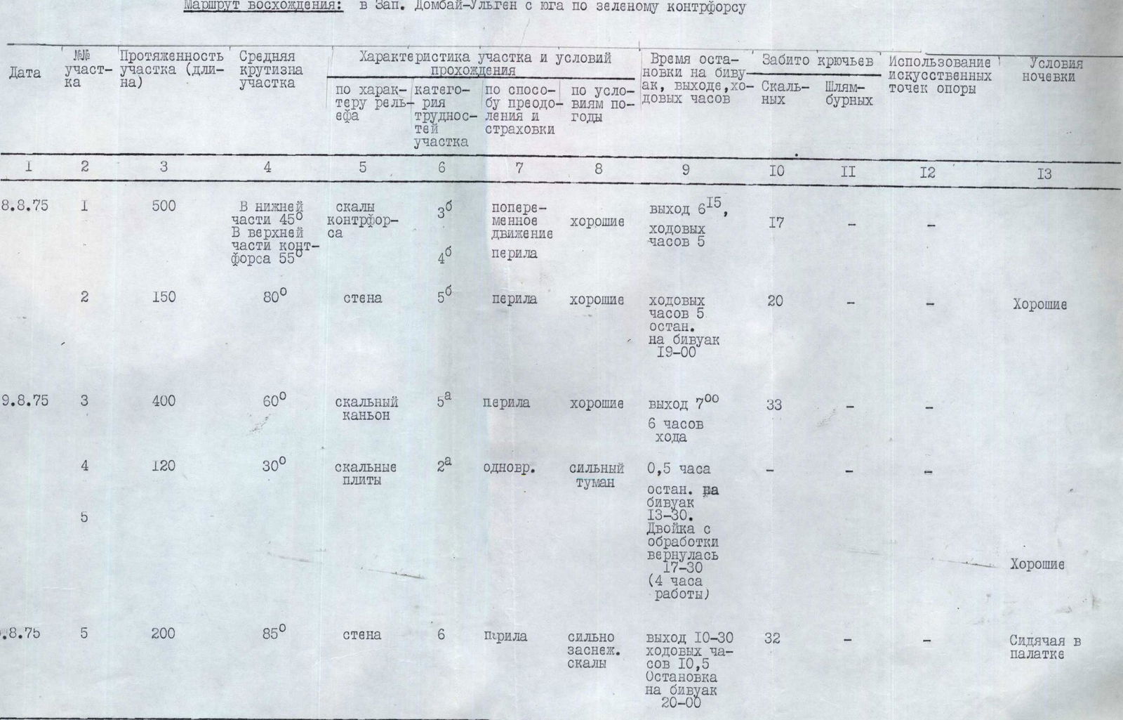
- Ascent route: Zapadny Dombay-Ulgen (4037 m) (5B category of difficulty) from the south via the green counterfort.
- Ascent description: height difference 950 (to the ridge) + 100 = 1050 m. Average steepness 60°. Length of the complex section 350 m.
- Number of pitons driven:
- rock 102
- ice —
- bolt —
- Number of travel hours: 27 + 4 hours of processing on the 2nd day + 30 minutes to the summit.
- Number and nature of bivouacs: 3 bivouacs 1st and 2nd good, 3rd — sitting in a tent.
- Team name: Team of the alpine camp "Domбай" CS SDSO "Burevestnik"
- Surname, name, patronymic of the leader and participants and their qualification: KHUBIYEV Naurus Magomedovich — leader 1st sports category PADVA Leonid Grigorievich — participant 1st sports category KAYDANOVSKY Mikhail Naumovich — CMS KOROTKOV Vadim Alexandrovich — MS MOLOTCHNIKOV Yefim Isaakovich — CMS VITSEV Vyacheslav Viktorovich — 1st sports category
- Team coach: MAGOMEDOV Khadzhik Kurmanovich
- Date of departure and return: 7–11 August 1975
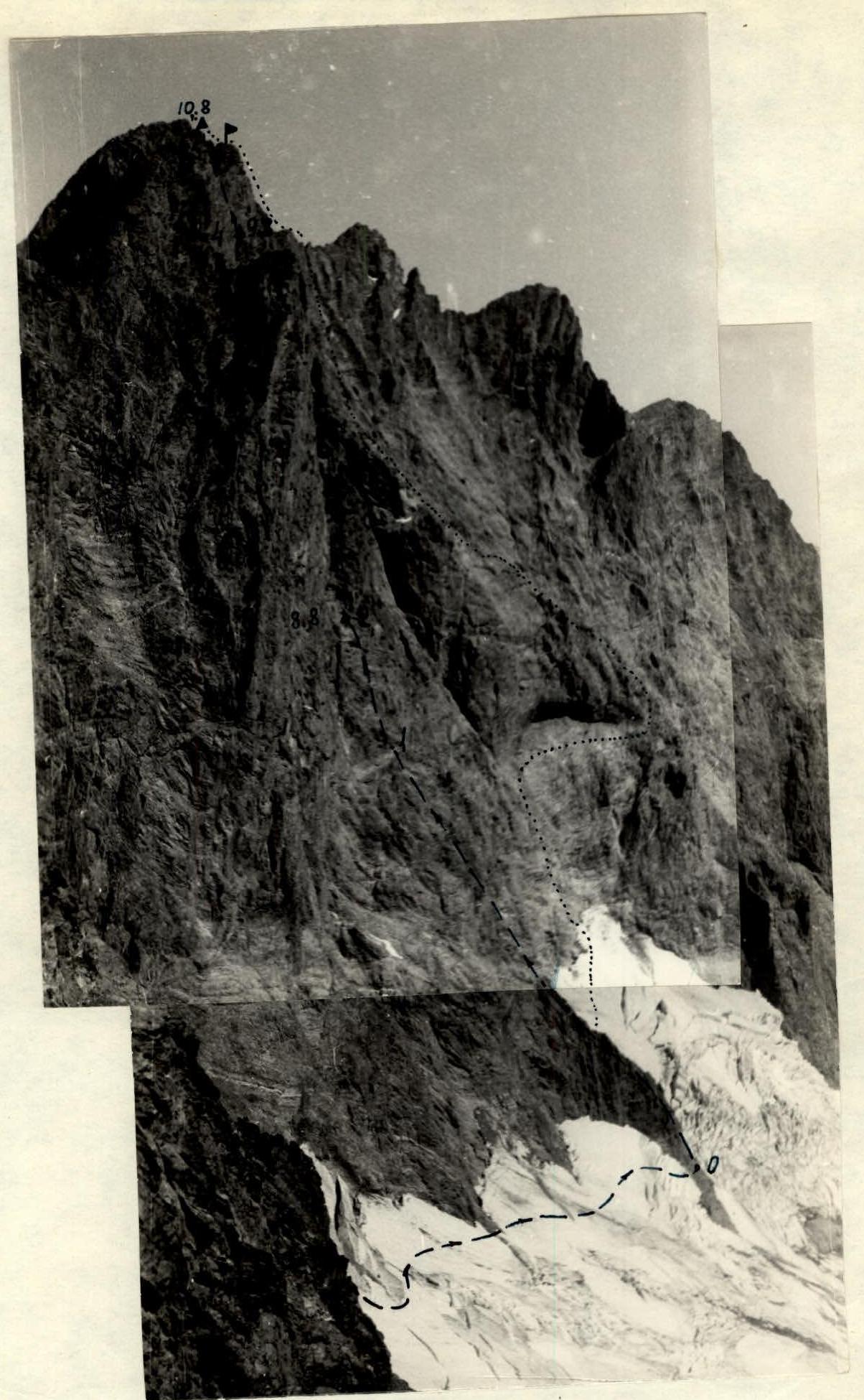
Western Dombay-Ulgen from the south
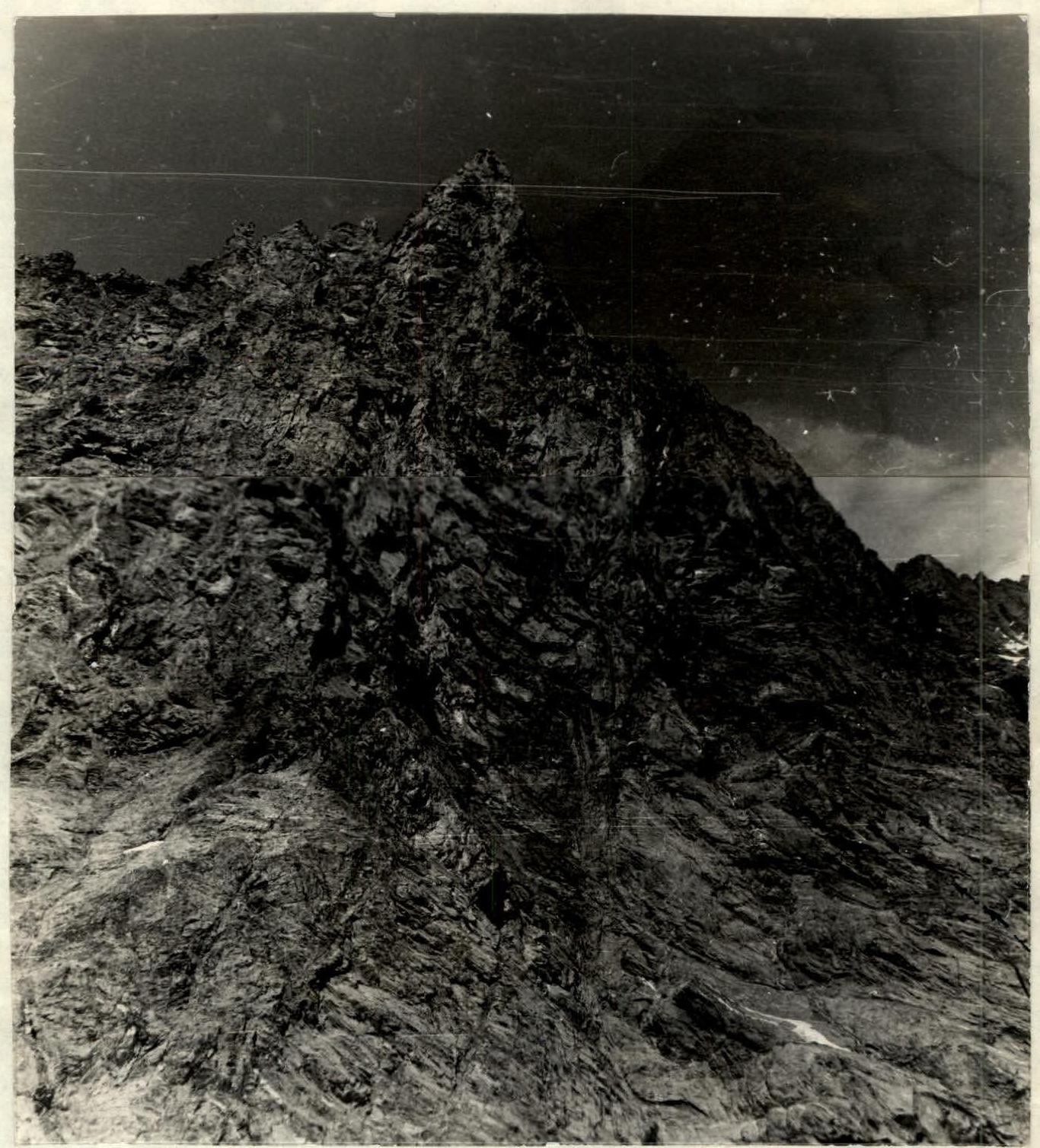
The team of climbers from the alpine camp "Domбай" was attracted by the sheer kilometer-high southern wall of Zapadny Dombay-Ulgen. The well-known route leading to the Western peak from the south passes through a wide rock mulde with an exit to the right of the peak. The chosen route is significantly to the left and leads to the ridge to the left of the peak. The exit to the ridge is a sheer, and in some places overhanging wall. The most logical start to this route is the "green counterfort" (the name is explained by the presence of grass on the ledges of the lower, not steep (45°) part). On August 2-3, a reconnaissance group (Vitsev, Padva) was under the southern wall, examining and photographing the route, monitoring the wall's condition (no rockfall was recorded). At a height of 300 m from the glacier, the counterfort abuts a light brown wall with overhanging eaves. The tactical plan included:
- a bivouac under this wall with processing;
- a second bivouac — under the summit wall;
- a third bivouac — on the ridge TsDSA–Zapadny Dombay.
The technical preparedness of the group allowed them to climb the most difficult 160 m of the wall on the first day without processing and spend the night in a rock canyon on the left part of the yellow wall. On the second day, the sheer 200 m summit wall required processing, and while the lead pair processed 120 m of the route, the rest of the group prepared a bivouac on a ledge under the wall. A thunderstorm with hail that passed during the night delayed the possible exit by 5 hours, and the team spent the next night on the ridge TsDSA–Zapadny Dombay, sitting in a tent. In good weather, it is possible to plan a bivouac on route 46 (according to Sasorov) in the area of the triangle.
The team had with them:
- titanium equipment
- combined and channel rock pitons
- bolt pitons
- expansion bolts
- ladders.
Since the southern wall of Zapadny Dombay-Ulgen is located beyond the Domбай pass and there is no direct radio communication with the alpine camp "Domбай", the team was supplied with an observation group, with which they maintained regular communication using "Vitalka-M" radios. The observers were almost always in visual contact with us, and communication with the camp was never disrupted. The observers were climbers from the alpine camp "Domбай":
- Tanya Makarova
- Sasha Savin
- Vanya Tulaev
II. Description of the route passage
On August 7, 1975, a group of six climbers and three observers left the alpine camp "Domбай" towards "Ptyшские ночевки". After ascending to the "Domбай" pass, the group set up a bivouac on a shoulder on the northern side of the pass. Khubiyev and Padva, along with two observers, climbed to the pass to show the observers the planned ascent route once again and agree on the points for communication with the group and the camp. On August 8 at 5:00, the group left the initial bivouac and began descending from the Domбай pass to the south towards the base of the green counterfort. The glacier was heavily crevassed; navigating through the crevices, they finally reached the randkluft and crossed it. At 6:15, they began working on the rocks of the green counterfort.
R1: From the base of the counterfort straight up along a not clearly defined ridge. Rocks of medium difficulty. Piton belay. In some places, there are short wall sections (3–5 m) and even small overhanging sections, where belays are organized. The ridge leads to a steep rise of the green counterfort. Difficult rocks:
- The first climber wears climbing shoes;
- The rest follow on the rope (two ropes). Then they start moving left and up towards the base of the yellow wall. During the route reconnaissance, it was immediately clear that the yellow wall, intimidating with its steepness, would be one of the key points. Now they can take a good look at this place. Out of the two previously considered paths, they choose the one leading left and up to the edge of a deep canyon (crevice). They traverse along the yellow wall for 40 m and approach its left part. The length of R1 is 500 m. Overall steepness 50°. A total of 17 rock pitons were driven on this section. The movement is mostly alternating, with belays organized in some places as mentioned above. The first climber in the group goes on a double rope throughout the route, carries a lightened backpack, and moves without it only on sections R2 and R5.
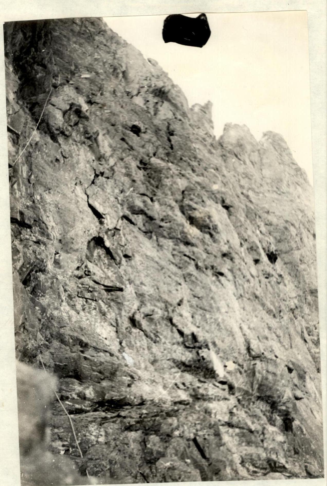
R2. After a short rest at 12:00, they begin ascending the yellow wall. Leonid Padva goes first. He wears climbing shoes, has no backpack, and is equipped with a full arsenal of pitons. For the first rope length, Leonid climbs straight up through steep, in some places overhanging rocks, with an average steepness close to 90°, and reaches a horizontal ledge (4 pitons). Here, a belay anchor is organized. The second rope length involves traversing along the ledge to the left and, before reaching its end, climbing up (10 m) through very difficult rocks, followed by an extremely difficult traverse to the left and, through overhanging rocks, an exit into an internal corner with overhanging rocks (7 pitons). The third rope length goes slightly to the left and then straight up through steep, very difficult rocks to a deep internal corner with a ceiling. The walls of the internal corner are damp (4 pitons). The fourth rope length: from under the overhanging rocks to the left (extremely difficult exit) and then up through steep rocks to a canyon with a grotto and a stream (5 pitons). Here is a platform where they can organize a bivouac. The stream in the canyon is the only place on the route with water. From below, the bottom of the crevice is not visible, and the existence of a stream could only be guessed. Therefore, they brought a small supply of water, from which they can now free themselves. Upon reaching the stream, Leonid shouts to the others that they can drink without conserving water. They are extremely thirsty due to the fine weather and the sun heating the rocks of the southern wall. The first rope team reaches the platform at 16:00, and the last climber, Vyacheslav Vitsev, ascends at 19:10. Removing pitons from the passed section was extremely difficult. Using pendulums and extensions made from cordelettes, Vyacheslav left only one piton unremoved, which was driven during the traverse of the internal corner. The length of R2 in height is 150 m, the average steepness is 80°, and 20 pitons were driven. The first climber passed this section using free climbing without artificial support points; the others ascended on the rope with jumar and étriers, without pulling their backpacks, as their weight did not exceed 12–15 kg. On the platform, they build the first control cairn.
The second day of the ascent — August 9, 1975. Departure at 7:00. R3. From the bivouac, they begin ascending straight up through the right part of the canyon, along steep, smooth rocks (60–70°) with individual overhanging brows (3–5 m), and then move to the right onto a ridge (3 rope lengths). 13 pitons were driven; the rocks are difficult. Then they move along the ridge. In the upper part of the ridge, they cross to the left to the stream and ascend along the left wall of the canyon to the top of the ascent of the green counterfort (3 rope lengths — 8 pitons). There is an option to ascend along the ridge without crossing the stream to the left, directly under the summit tower of Zapadny Dombay-Ulgen. In the upper part of the ascent, there are many loose rocks! The length of R3 in height is 350 m, the average steepness is 60°, and 33 pitons were driven. The first climber went free climbing, the others on the rope with backpacks. They reached the top of the ascent at 12:00.
R4. The top of the green counterfort ascent is a wide rock mulde bounded by a completely sheer, and in some places even concave, wall of the Zapadny Dombay ridge. Through the mulde, moving simultaneously, they traverse under the tower of the Western peak (3 rope lengths). The weather starts to deteriorate. A strong fog appears. It becomes difficult to choose the path for further ascent to the peak. Fortunately, during the rest after completing R3, the visibility was excellent, and they managed to outline the route for ascending the sheer tower. At the base of the wall, they find a ledge where they can pitch a tent. They decide to begin reconnaissance and processing of the further path. At 13:30, the pair Padva — Korotkov begins processing the summit tower.
R5. From the ledge under the summit tower, Leonid Padva ascends first up and then moves to the right side of the tower. Difficult rocks, steepness 85°, 6 pitons driven (1 rope length). 2nd rope length: along the right side of the tower. First along a short ledge, and then along a sheer internal corner straight up (extremely difficult climbing). In the upper part — overhanging rocks. 8 pitons driven. 3rd rope length:
- Traverse to the right for 3 m under overhanging rocks
- Then ascent up through steep, heavily destroyed rocks (blocks)
- 4 pitons driven Having pitched 3 rope lengths, the pair returns to the "platform" at 17:30. Further ascent to the top remains problematic. The path to the end is not visible; only in the breaks of the fog, the top of the ridge appears unexpectedly close, and then implausibly far. On the platform, they build a control cairn and settle in for the night (photo).
The third day of the ascent — August 10, 1975. At night, severe bad weather starts: thunderstorm, large hail. The layer of hail on the platform exceeds 10 cm. The hail, and then graupel, do not cease until 9:30. Then the graupel stops, and individual breaks appear in the clouds, and the group decides to continue the ascent. Departure at 10:30. By 12:00, the first pair has passed 3 rope lengths of the belay and, waiting for the rope to be freed below, begins further ascent (at 14:00). Strong wind, very cold.
Continuation of R5
4th rope length: ascent straight up through steep, in some places overhanging rocks. The nature of the rocks: inclined ledges, balconies with overhanging walls, and small cornices. 6 pitons driven. The 5th rope length leads to a small depression in the ridge to the left of the Western peak. The steepness of the last rope length reaches 90°, with three overhanging sections. Climbing is extremely difficult. 8 pitons driven. Backpacks have to be pulled on this section. The first rope team reaches the ridge at 18:00. At 20:00, the entire group gathers on the ridge. They settle in for the night immediately. R5 proved to be the most difficult section of the route. Its overall length in height is 200 m, the average steepness is 85°. 32 pitons were driven. The first climber passed the entire section using free climbing; the others ascended on the rope, using étriers.
The fourth day of the ascent — August 11, 1975. In the morning, at 7:30, the group ascended to the Western peak of Dombay-Ulgen without backpacks (8:00) and, leaving a note, descended to the bivouac. From here, following Sasorov's route (45 category of difficulty), they all descended to "Ptyшские ночевки" by 17:00 and from there to the alpine camp "Domбай".
Section 2 "Yellow wall"
Tables of the main characteristics of the ascent route
Section 5. Second rope length processing
Comments
Sign in to leave a comment