
Description of the first ascent of the traverse of the Dombay-Ulgen massif from the Western peak to the saddle with ascent to the Western peak via the NW wall
5B category of complexity July 12–17, 1962
The Dombay region, where the Dombay-Ulgen massif is located, lies in the border zone between the Western and Central Caucasus, so it combines the nature of:
- the humid warm Western Caucasus;
- the more continental Central Caucasus.
The territory of the region is part of the Teberda State Reserve.
The climate of the Dombay region depends on the impact of several factors, the most important of which are:
- year-round influence of the western air transfer (warm and humid air masses);
- influence of Ciscaucasia - dry and hot in summer, cooled in winter.
Due to the climatic conditions in the Dombay region, there are large fluctuations in the height of the snow line. For example:
- the height of the snow boundary of the Dombay-Ulgen massif is 2900 m;
- not far from the standing peak of Alibek - 3200 m.
The combination of forest, proximity of glaciers and eternal snows, abundance of peaks of various difficulty categories, simplicity of hikes to most of them makes the Dombay valley the center of alpinism in the Western Caucasus. Here, in the Dombay, Amanauz and Alibek gorges, there are alpinist camps:
- "Alibek";
- "Dombay";
- "Red Star";
as well as a number of tourist bases.
Currently, all peaks have been conquered in the region. The Dombay-Ulgen massif, located in the main Caucasian ridge, between the Dombay pass in the south and the Bu-Ulgen wall in the north, rises above the entire Western Caucasus as a huge stone boulder, representing a major carding (see photo 1). Its three peaks:
- Main (4040 m);
- Western (4037 m);
- Eastern (about 4000 m);
are steep-walled to the surrounding glaciers and are separated from the rest of the world by significant ridge drops. The relative height of the massif above the bottom of the valley reaches 2000–2500 m.
At the Main peak, the ridge makes a turn of about 90°, after the turn is the Eastern peak. It is connected to the Main one by a ridge, which has a significant drop and is a series of sheer steps. From the Bu-Ulgen wall, the Eastern peak rises with a three-hundred-meter tower. From the Bu-Ulgen gorge, a thousand-meter slab wall with a steepness of about 70° rises to it. To the south, all the peaks of the Dombay massif break off with 1200–1300-meter walls of average steepness of 70° with significant sheer sections.
The average steepness of the northern side of the massif from the Main peak to the Western one is 55°, however, there are also counterforces with a steepness of more than 60° (see photo 2) (for example, the route passed, as well as an interesting route along the "triangle" - a wall exiting directly to the Western peak).
There are no easy paths to the top of Dombay-Ulgen. The simplest of the routes passed is to the Main peak from the Dombay saddle - 3B category of complexity.
For the first time, the Main peak of Dombay was conquered in 1933 along the ridge from the Fischer saddle. In 1937, the peaks of Western and Main Dombay were traversed with ascent to the Western one.
In 1938, a group led by V. Budanov ascended the northern wall to the Main Dombay directly from the glacier (yearbook, 1951, p. 352). Finally, in 1948, the last peak of the massif was conquered - Eastern Dombay along the southern wall - 5B category of complexity.
From 1951 to 1961, routes of the highest category of complexity were laid on the Dombay-Ulgen massif:
- Eastern Dombay-Ulgen along the eastern wall - second place in the USSR championship (1954);
- traverse of the Dombay-Ulgen massif from east to west - second place in the USSR championship (1954);
- northern wall on the Main peak of Dombay-Ulgen - passed in 1956;
- southern wall on the CDS peak - passed in 1960;
- northeastern wall on Eastern Dombay-Ulgen - passed in 1961.
The route passed in 1962 by a team of climbers from the Kiev City Council of the "Spartak" society along the northwest wall of the Western Dombay-Ulgen also belongs to the number of very difficult ones.
The northwest wall is a clearly defined counterforce with a steepness of 55–60° in the lower part, and a wall ("tower") with a steepness of 70–75° in the upper part. To the left of the counterforce is a steep snow-ice slope, resting its lower part against a rock wall, to the right is an ice couloir separating the counterforce from the "triangle" wall.
When discussing the options for ascent, the team came to the conclusion that the most logical way to ascend is to ascend to the tower along the rock counterforce. This conclusion was later confirmed, as during the ascent along the wall it became possible to leave the counterforce only in the upper part under the "tower". This route attracted the attention of Kiev climbers with its beauty and logic back in 1961. It was especially attractive that the entire ascent route was to be clearly visible from the Dombay glade area.
In 1961, reconnaissance ascents were made to the peaks:
- Maly Dombay (V. Ovcharov, G. Polevoy);
- Main Dombay (V. Ovcharov).
As a result, the ascent route was planned and an approximate description was compiled.
In 1962, the team members, to check the state of the route and make a throw-in of food and equipment, made an ascent to the Main Dombay-Ulgen on July 4 along the 3B category of complexity.
Due to the fact that all team members had undergone good pre-mountain training, their preparation in the mountains was limited to one ascent of the 3rd category of complexity.
The following climbers were selected to participate in the assault from among the gatherings of the Kiev City Council of the "Spartak" society:
- G. V. Polevoy - Master of Sports of the USSR - team leader;
- V. V. Ovcharov - Master of Sports of the USSR - team coach;
- A. A. Luts'k - Master of Sports of the USSR - participant;
- A. I. Klokova - 1st sports category -;
- V. A. Lutsok - 1st sports category -.
During the inspection of the route, it was determined that the movement along the counterforce would mainly take place along short walls with sections of difficult rocks covered with flow ice. In some areas, a tiled structure of rocks was visible. The upper part of the route - the "tower" - was difficult to see. However, due to the large extent of the wall, we assumed that we would also encounter significant difficulties here. In addition, there were no convenient sites for organizing an overnight stay along the entire route.
Based on these conditions, the tactical plan for the assault on the wall was as follows:
- exit to the route at 3:00 in order to approach the lower section of the rocks by the time they warm up in the sun;
- passage on the first day of the maximum possible section of the route, stopping for an overnight stay in any suitable place on the wall 2 hours before dark, and organizing, obviously, a sitting bivouac;
- maximum lightening of the load taken to the wall by using high-calorie products, as well as throwing in food to the Main peak;
- careful selection of group and individual equipment, including the use of the "Kievlyanka" radio set weighing 700 g;
- use of special equipment (drill bits, titanium pitons, aluminum and wooden wedges, ladder-steps);
- a set of signal flares was taken to communicate with the camp.
On July 12 at 11:00, the group left the Dombay camp. The task of the first day was to approach the wall as closely as possible and spend the night on the upper "barranii lby" of the glacier under the ridge of Maly Dombay. This made it possible to review the ascent route once again before the assault.
Description of the assault on the northwest wall of Western Dombay-Ulgen with traverse to Fischer's saddle via the Main peak
On July 13 at 3:00, we leave the bivouac and, along the glacier, approach the beginning of the route in 1 hour. We cross the bergschrund in crampons, then pass along the ice slope with a steepness of 45° about one rope length and enter the black rocks of medium difficulty to the right under the red pipe (water flows down the couloir on the left). Further, the path goes along the rocky ridge to the left, on the ridge under the red pipe a control cairn is built.
From the bergschrund to the cairn, there are one and a half rope lengths. Average steepness 55°. Then we move along the ridge to the right of the couloir, along which water flows. From here we move straight up along the wet slabs with a steepness of 45–50° with sections up to 60°. One rope length, two pitons. Then along a not clearly defined inner corner with a steepness of 55–60° with careful belay - 4 rock pitons, one and a half rope lengths.
The nature of the rocks: slab-like, smoothed like "barranii lby" with a small number of holds, the structure is tiled. In some places - flow ice. Transition along the flow ice 45° to the wall with a length of one rope length. One ice piton is driven. Then we pass along the inner corner with a steepness of 55° one rope length. Three rock pitons are driven. We exit to an ice-firn slope with a steepness of 60°, along which we pass one rope length. At the exit of the rocks, a second control cairn is built. One ice piton and two rock pitons are driven. Adhering to the left side of the snow-ice slope, we move in the direction of the rib (it is not possible to walk on the snow, as the flow ice is covered with a thin layer of snow and there are signs of falling stones). The slope is passed on the left near the rocks on ice with chopping of steps. We enter the rib along a 15-meter very difficult wall 90°, requiring careful piton belay, the first one passes without a backpack. Three rock pitons are driven.
From the wall along inclined slabs with a steepness of 60–65°, covered with flow ice, we pass 10 m, one shackle piton is driven for belay. We approach the wall with a steepness of 70°. The wall has narrow inclined shelves on which it is possible to organize piton belay. The holds are mostly from below, the rocks are tile-like in structure. The length of the wall is 50 m. When passing the wall, 6 pitons are driven. The wall turns into a not clearly defined rib with a steepness of 50° and a length of about one and a half rope lengths. The rocks are very destroyed and maximum caution is required, as all participants are under each other. From the rib, we move to a snow slope - one rope length, steepness 45°, snow is deep. From the snow along the flow ice - half a rope length, 50°, one ice piton is driven, we move to rocks. After the ice - very complex smoothed slabs - 1 rope length, 60°. There is nowhere to drive pitons, as the slabs have no cracks. The section was passed in 2 hours and required driving two shackle pitons with hanging ladders. Then we ascend along a 25-meter wall 65°, on which there is almost no possibility to drive pitons. Two pitons are driven on this section. Then we move along the middle ridge, with a steepness of 55–60°, on both sides of which there are snow-ice couloirs, the holds are bad, 6 pitons are driven. Throughout the entire route of the first day, there were no sites for overnight stays and for gathering the whole group together. The exit along the wall to the ridge, to the left along complex rocks with a steepness of 80°, length 4–5 m, covered with flow ice; at 20:00 we stopped for an overnight stay. After an hour's work - chopping ice, we settled on very narrow shelves for a semi-sitting-semi-hanging overnight stay at a distance of 2–3 m from each other.
On July 14, we move from the overnight stay to the end of the ridge. We exit to a steep snow-ice slope with a steepness of 45° and move along it 1 rope length to a rock island. The exit to the island is with very complex climbing along a smoothed slab 5–6 m. Then we pass 1 rope length along the wall with a steepness of 60° along rocks of medium difficulty. Then we pass along a steep ice couloir to the right and upwards along islands embedded in the ice, bypassing the edge of rocks and ice, the base of the "balda" for two rope lengths with a steepness of 70°, under the left wall of the couloir, careful piton belay, 3 pitons are driven. The section had 2–3 m of complex climbing in some places.
We cross the ice couloir to the right along the course to the corner of the tower and go behind the bend, steepness 60°, length 1 rope length. Belay through rock outcrops and a duralumin wedge.
12:00. We go around the tower to the right, traversing 4 rope lengths. The rocks are complex, but there are many outcrops for belay. We exit to an inclined shelf.
15:00. From the inclined shelves, we organize a sporty descent into the ice couloir. Adhering to the edge of ice and rocks, we approach an inclined slab with a steepness of 60°, length 1 rope length, along which water flows. One piton is driven.
After the slab, we cross the ice couloir - half a rope length, steepness 50°, with chopping of steps to a rock island.
We traverse without gaining height an island and exit to an ice slope with a steepness of 60°. The further path passes along the edge of rocks and ice with careful piton belay. The length of the section is 2 rope lengths. We approach under the wall. The ascent up along the ice slope is complex, as the rocks are smoothed and have few holds. When ascending along the ice slope to the wall, the following were driven:
- 6 rock pitons;
- 5 duralumin wedges;
- 1 wooden wedge.
To the left of the wall are red rocks, and along the slope - black ones, along which water flows. Not reaching half a rope length to the end of the ice slope, we turn left to the wall. The rocks are complex, in some places - smoothed slabs. The length of the wall is 1 rope length, steepness - 60°. For belay, the following were driven:
- 4 rock pitons;
- 1 wooden wedge.
After the wall - one and a half rope lengths along smoothed rocks to the exit to the ridge, 6 rock pitons are driven. The upper part of the wall, due to the complexity of the rocks, required driving pitons and wedges as supports. The first one went without a backpack.
The exit to the ridge is at 21:00. The group stopped for an overnight stay 15 minutes' walk from the Western peak, on a shelf on the southern side of the ridge. The overnight stay is sitting.
On July 15, the group left for the Western peak of Dombay-Ulgen at 8:00 with light packs. The group reached the peak in 15 minutes' walk. Returning to the bivouac at 10:00, they began to move along the ridge towards the Main Dombay-Ulgen. They were on the peak of the Main Dombay at 13:30, where they found their throw-in of food and equipment. Due to thick fog, they did not continue moving that day. A bivouac was set up on the ridge descending towards Eastern Dombay-Ulgen, on sites.
The path from Western Dombay to Main Dombay is a sharp ridge with "gendarmerie". When passing the ridge, belay was used through outcrops, and when descending or bypassing "gendarmerie" - piton belay.
On July 16, the next day, due to bad weather (strong wind, snowfall).
The descent began with an improvement in the weather, only at 12:00 along the route of 3B category of complexity, and at 16:00 they safely descended to the Ptysh overnight stays.
During the traverse from Western to Main Dombay, as well as the descent from Main Dombay to Fischer's saddle, 21 pitons were used.
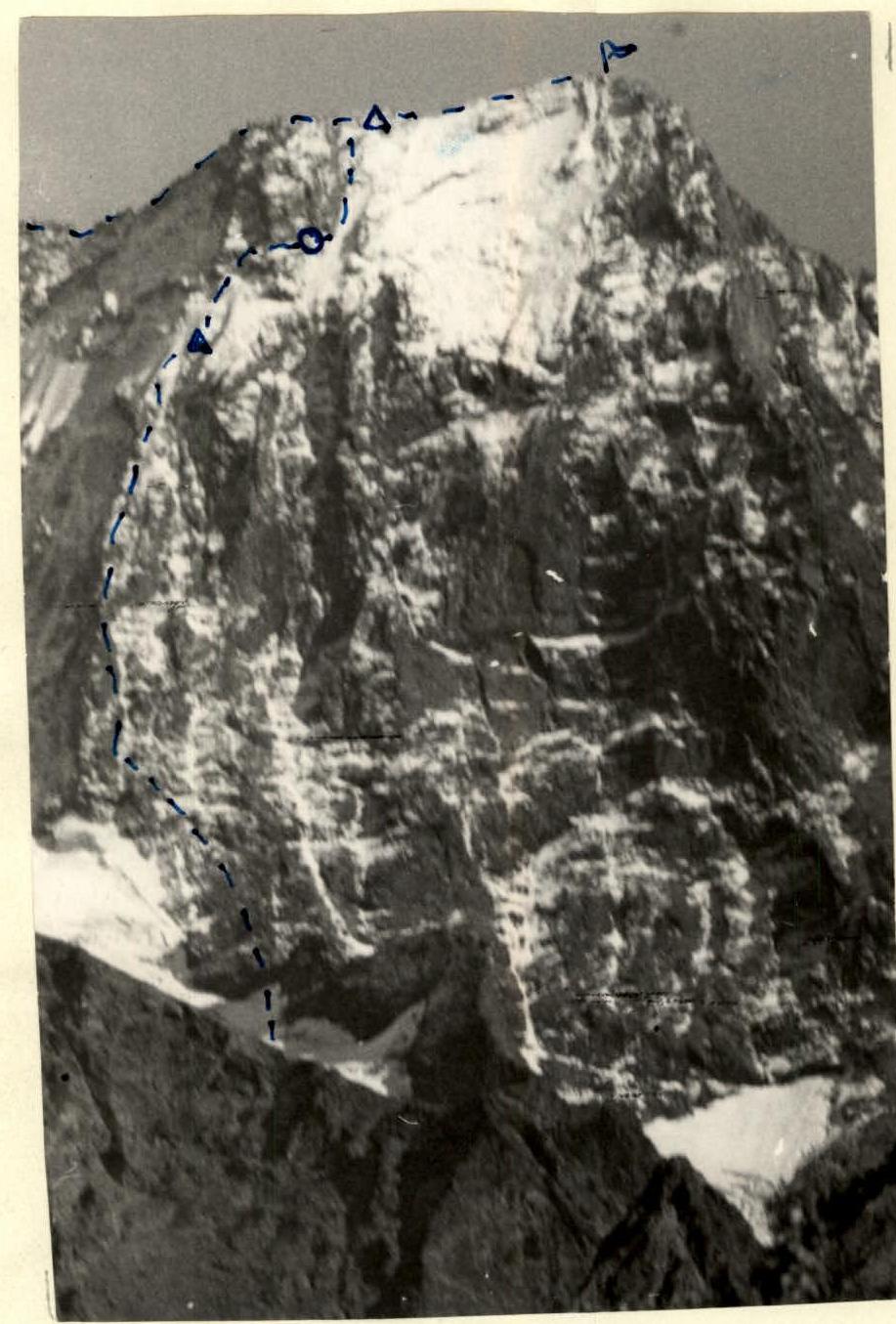 Sketch of ascent via NW wall to West. Dombay-Ulgen.
Δ - bivouac site of the assault group, — — path of the group
О - place of organization of a good overnight stay.
Sketch of ascent via NW wall to West. Dombay-Ulgen.
Δ - bivouac site of the assault group, — — path of the group
О - place of organization of a good overnight stay.
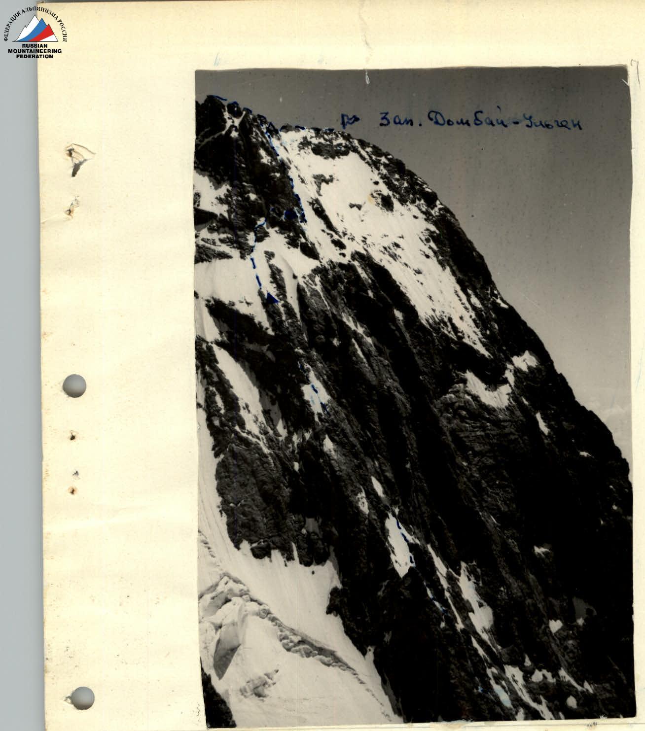 Profile of the wall of West. Dombay-Ulgen.
Comments
Sign in to leave a comment