USSR Climbing Championship 1973. Technical Climbing Category
Ascent of Main Domбай-Ulgen peak via the South Face (First Ascent)
The route was climbed by the team from the "Dombay" mountaineering camp under the "Burevestnik" sports society.
Coach: Master of Sports of the USSR, R.P. Stroganov.
Western Caucasus
— 1973 —

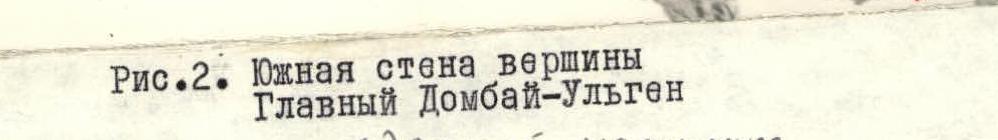
Fig. 2. South Face of Main Domбай-Ulgen peak
Since the assault team was within sight of the observation group for the first three days, the latter was able to provide clear guidance to the assault team.
The liaison group consisted of:
-
- N.V. Silkov, 2nd sports category — leader
-
- Yu.N. Kalashnikov, 3rd sports category — participant
and was stationed at the Dombay Pass, from where they maintained communication between the assault team and the "Dombay" mountaineering camp.
6. Route Description (Ascent Log)
First day: August 3, 1973.
At 11:00, the team consisting of Kоротков, Карпов, and Молочников left the bivouac on the "green spur" descending from the peak Западный Domбай-Ulgen to start processing the route. We approached the start of the route via the South-Dombay glacier. The route begins in the middle part of the "triangle" — a rock massif bounded on the right by a gully with a stream and on the left by sheer monolithic walls of a large rock couloir leading from the Western peak of Domбай-Ulgen.
Vadim Коротков was the first to climb the wall. The weather was overcast, but the rocks were dry, so Vadim wore galoshes.
The first rope length — section R1 — was covered relatively quickly. The slope was not too steep, and there were holds available. However, the second rope length required all of Коротков's experience as a rock climber. And he had significant experience:
- He had repeatedly placed in competitions at the championships of Leningrad and the "Burevestnik" sports society.
- He was the champion of the USSR in mountaineering in 1970.
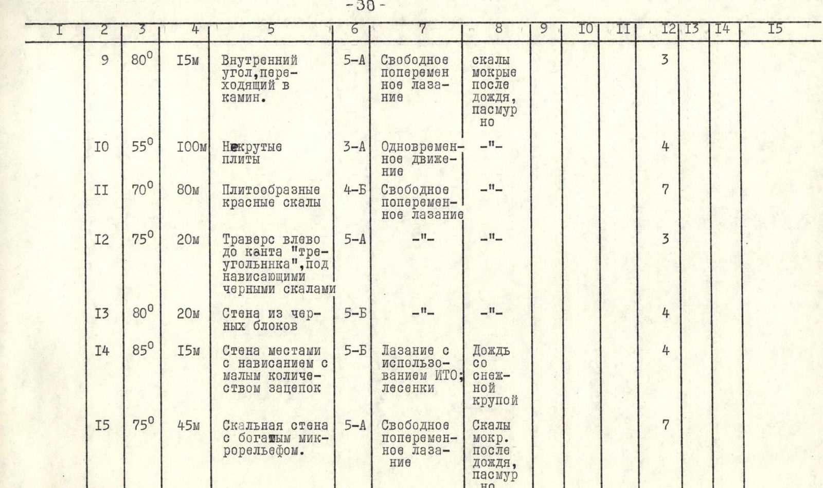
After climbing vertically up steep slabs with нависающими sections (R2), he had to stop: a smooth, steep slab without holds or cracks required the use of pitons. With great difficulty, Vadim traversed to the right using free climbing to a small external angle (R3). The climbing was extremely challenging even in galoshes.
The next section was somewhat easier, but overcoming the subsequent section (R4) still took Коротков about an hour. The path went straight up towards a нависающей white wall with black streaks via steep slabs. The exit to this wall was via a steep slab with microscopic holds (R5). Under the white wall, there was a wide (50–60 cm) ledge. We stored unused equipment on this ledge and descended to the snow. The route processing was completed by 16:00.
Second day. August 4, 1973. According to the initial plan, we were to reach the top of the "triangle" on this day, which was approximately 400 meters of ascent. Therefore, we rose early and approached the previously processed wall by 5:00. The observation group remained at the bivouac:
- D.P. Ivanov
- I.P. Shvedchikov
Today, Yu. Карпов was the first to climb. Having passed the processed section, he hurried to put on his galoshes, but... it started raining.
The team gathered under the нависающей wall on the ledge. The rocks were getting wet, and morale was dropping. A brief consultation led to the decision to continue upwards, but certainly not in galoshes. Карпов, without his backpack and with a full set of pitons and ladders, began to move. A relatively easy traverse along the ledge to the right (R6) allowed him to reach a wall that could be used to bypass the нависающий section. Although the average steepness of the wall was not too great — 75° — its character was stepped, and the transitions between the steps — of which there were three — were made via sheer wall sections 5–6 meters high (R7). Climbing was complicated by the wet rocks and the continuing drizzle. Карпов had to hang three ladders using artificial holds.
Further on, the steepness of the rocks decreased, and grass grew between the slabs. Climbing on wet grass with a steepness of 55° was not very pleasant. This section (R8) was traversed with maximum caution. The path went left and upwards, where a small platform was visible.
At the end of section R8, we reached this platform under a нависающей wall. The нависание was quite large and formed a grotto at its base, where three people could sit. The rain stopped, but the rocks were still wet.
From the platform in front of the grotto, a finger of rock that had broken off from the wall was visible 80–100 meters above to the right — our landmark for reaching the right edge of the "triangle". A small ledge led from the finger along the white, sheer, smooth wall. However, traversing these 100 meters on wet, sheer rocks would be very challenging.
We decided:
- The grotto should be used to bypass the нависающая wall from the left.
- A possible exit to the left edge of the "triangle" should be explored.
This variant was also considered as one of the possible options during observations from below.
Bypassing the нависающая wall from the left went via an internal angle that turned into a chimney (R9). Climbing was above average difficulty. The rain stopped, but the rocks were still unpleasant and wet. After the chimney, two rope lengths of non-steep slab-like rocks led to the left edge of the wall (R10). Further on, the slabs became steeper (R11), and eventually, we reached under the wall.
The wall was composed of black blocks and нависала significantly on the right side. On the left, near the edge of the "triangle", the wall was less steep.
Карпов traversed to the left (R12), after which difficult climbing vertically upwards began (R13). This path was perhaps the only passable one on this section of the "triangle" without using piton technique:
- To the right lay a нависающая, absolutely smooth black wall.
- To the left were completely smoothed, sheer walls.
Above, the character of the rocks changed, and the wall became steeper (R14). There were practically no holds, but there were sufficient cracks. Climbing was complicated by the fact that, as if on cue, it started raining again, this time with sleet. We had to use artificial holds and ladders. In some places, the wall нависала. This was one of the most challenging sections of the route.
The next rope length was traversed much more easily, especially since the rain stopped. The rocks were red, and it was clear that the wall was about to become less steep (R15). Another two rope lengths of relatively easy climbing (R16) brought us to a large ledge. The character of the wall changed completely — it became a series of wide ledges with grass, stepping upwards — this was the upper corner of the "triangle". To the right, the right edge of the "triangle" approached, and to the right of it, a stony, narrow gully was visible, blocked just above us by a huge rock. Not far away — within three or four rope lengths above us — on the right side of the gully, a steep snow ledge was visible — our intended exit into the cirque. The gully, as it appeared from up close, was constantly being shot through with falling rocks. Crossing it required great caution, very early in the morning.
We decided to set up a bivouac, especially since it was already 17:00. We chose a safe, flat ledge and pitched our tent. The site did not require much preparation: the ledge was quite flat. We settled in early — by 20:00. Twelve hours of continuous work did not encourage lengthy conversations.
Third day. August 5, 1973.
Today, we had to accomplish two main tasks. First, we needed to cross the stony gully as early as possible and exit into the cirque. Second, we had to clarify the path from the cirque to the summit. Therefore, we rose very early. By 5:00, the pair Коротков — Перковский had left the bivouac. Перковский was the first to climb today.
After traversing a relatively gentle scree slope simultaneously — which was the "apex" of the "triangle" — Перковский began to move along a steep, well-defined ridge on the left side (R19). The pair Карпов — Молочников dismantled the bivouac. On the site, we built a large cairn and left a note — this was a control cairn that any group ascending via the "triangle" would definitely see.
On section R19, we passed by a steep snow ledge on the opposite wall of the gully — the intended exit into the cirque. However, crossing the gully at this point was quite challenging — it would require several hours of serious work. Meanwhile, the sun had already risen, and soon rocks might start falling. We decided to ascend higher: there was another possible exit visible — a ledge along which a stream flowed from the cirque into the gully.
The steep ridge ended with a small scree ridge (R20) that abutted a vertical, smoothed slab. We were now 30 meters above the plug blocking the narrow gully to our right. This plug was clearly visible from the glacier with the naked eye.
The slab (R21) was climbed by Перковский using free climbing, except for the very top. The great steepness and scarcity of smoothed holds made this section one of the key ones on the route. Climbing was complicated by the almost complete lack of cracks for pitons in the upper part of the slab. There was no direct exit upwards, and to exit from the slab to the right via a traverse, Перковский had to hang a ladder on a piton.
One rope length of relatively easy, разрушенные rocks (R22) brought us to the level of the stream, where a transition into the cirque was visible. The exit into the gully via a slab-like wall — 2 rope lengths — (R23) presented no difficulties. Crossing the gully was also straightforward.
It was around 9:00 in the morning. We were sitting on the edge of the cirque; directly in front of us were numerous spurs descending from the ridge of Domбай-Ulgen into the cirque. The previously considered variant of exiting onto the ridge via a long spur to the right of the summit now seemed less logical: we were sufficiently high on the edge of the cirque, and to reach this spur, we would have to descend into the cirque and cross it. Exiting onto the ridge via a smaller spur descending into the cirque directly to the left of the summit tower seemed more logical.
This was the rightmost spur out of three that converged at the bottom in the cirque, forming a three-fingered "hand" lying on the shoulder of Main Domбай-Ulgen.
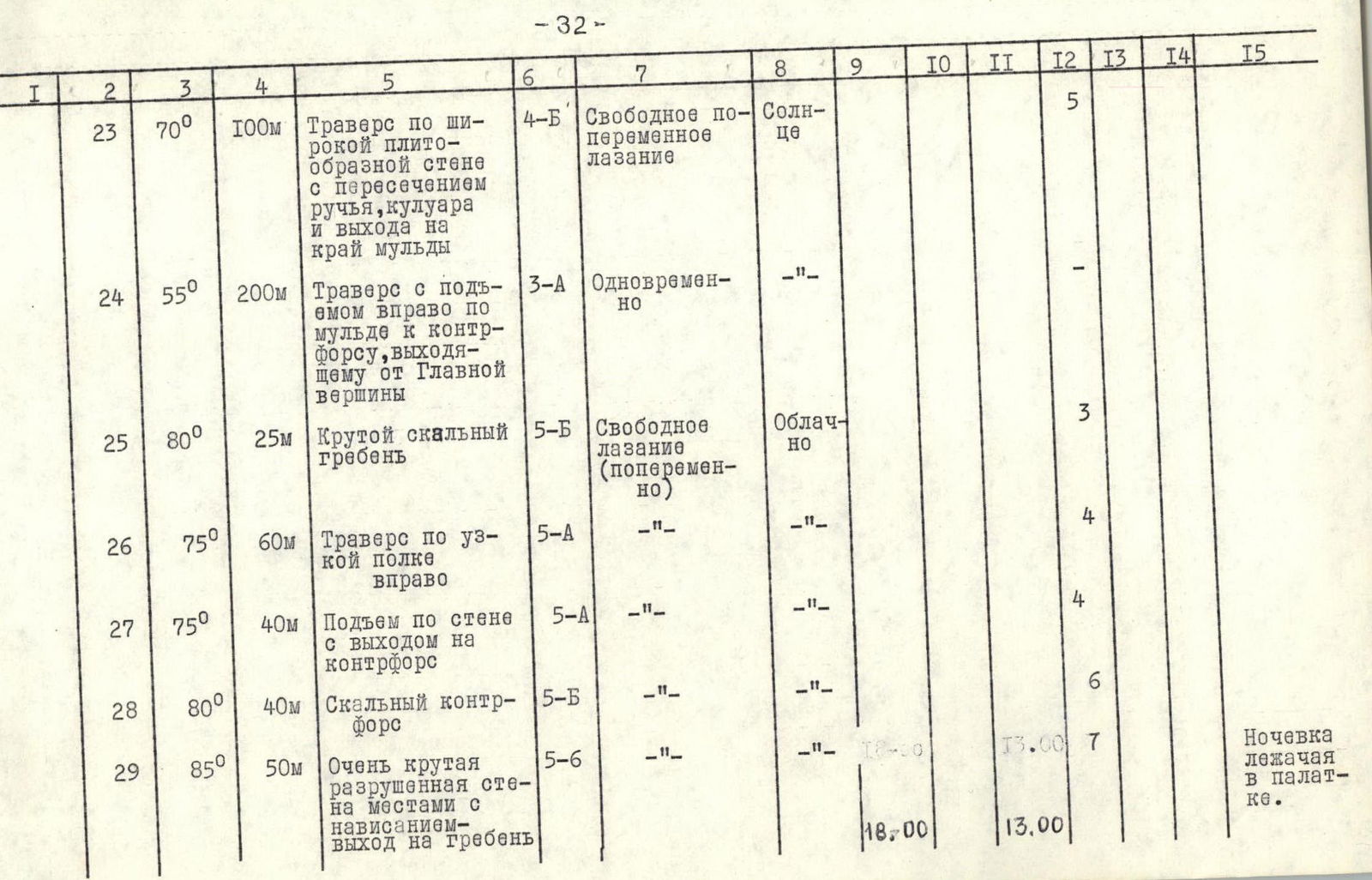
To reach this spur, we traversed the slope of the cirque with an ascent (R24). Five rope lengths of simultaneous movement brought us to the left of the three spurs of the "hand", slightly above its base. To reach the right spur, we first climbed directly upwards (R25). Vadim Коротков led the way. Climbing was very difficult; the spur was very steep at the beginning. Having climbed half a rope length upwards, Коротков began to traverse to the right along a long ledge. The rocks here, between the spurs, had a complex structure: a huge stone "pie" with layers 1.5–2 meters thick. A small protrusion of one of the layers on the steep wall formed the ledge. The traverse (R26) crossed the middle "finger" of the "hand" and brought us to the rightmost spur, which was to lead us onto the ridge. From here to the ridge of Big Domбай-Ulgen was approximately three rope lengths.
- The first rope length — the start of the ascent (R27) — was covered by Коротков relatively quickly, but then the steepness and complexity of the route increased significantly.
We had already been moving for over eight hours that day. We could have considered setting up a bivouac. But all signs indicated that the weather was about to deteriorate again. We decided to make the most of the remaining daylight.
Коротков moved directly along the sharp, steep ridge of the spur (R28). Climbing was very challenging. The rocks were composed of red blocks stacked on top of each other. It seemed as if the entire spur would collapse under your weight. This rope length was perhaps the most difficult and dangerous section of the route.
The first climber worked without a backpack and in galoshes. The neighboring spurs had abutted a wall resembling a huge concave lens; exiting onto the ridge there would have required the use of artificial holds.
Our spur also abutted a wall (R29); although this wall was steep, it had a positive angle and a relatively rich micro-relief. A small нависание in the middle part of the wall was bypassed to the right. Soon, we exited onto the ridge of Big Domбай-Ulgen. It would soon be dark — 18:00.
In a snow drift clinging to the rocks on the northern side of the ridge, we managed to carve out a platform with our ice axes before nightfall. We had dinner in the dark.
Fourth day. August 6, 1973. Over the previous day, having worked for 13 hours, we had actually completed the program we had planned for two days. This turned out to be very fortunate: on the fourth day, the weather deteriorated again. It was drizzling, and there was dense fog. Visibility was no more than 10 meters.
Weather conditions:
- Drizzle
- Dense fog
- Visibility no more than 10 meters
Directly in front of us, in the fog, the summit ascent route to Main Domбай-Ulgen peak was shrouded in mist. The summit was somewhere close.
We set out at 7:00. Молочников was the first to climb. Moving directly upwards along a non-steep ascent (R30), we reached the highest point after three rope lengths. The summit.
At 8:30, we began our descent via the classified route 3B category of difficulty along the North Edge. Finding this route in the fog was not straightforward.
On the same day, at 17:00, the group returned to the "Dombay" mountaineering camp.
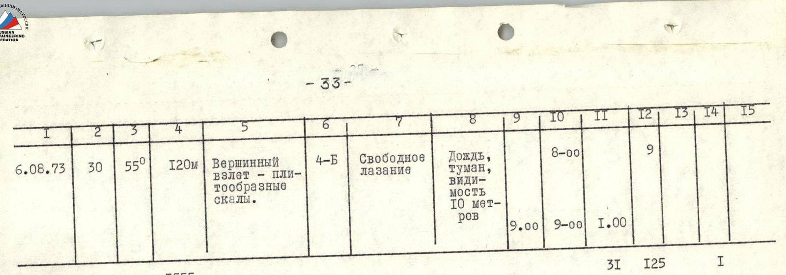
8. Table of Main Route Characteristics
Route: Ascent of Main Domбай-Ulgen via the South Face. Height difference — 1040 meters. Including the most challenging sections — 210 meters. Average steepness — 63°.
| Date | Section | Average Steepness | Length (by rope length) | Description and Climbing Conditions | Technical Difficulty | Climbing Method or Belay | Bivouac Conditions | Start Time | Time of Day | Hiking Hours | Rock Pitons | Ice Pitons | Piton Type | Bivouac Conditions |
|---|---|---|---|---|---|---|---|---|---|---|---|---|---|---|
| 1 | 2 | 3 | 4 | 5 | 6 | 7 | 8 | 9 | 10 | 11 | 12 | 14 | 15 | |
| 3.08.1973 | R1 | 65° | 40 m | Rock wall | 5 | Free alternating climbing; pitons | Overcast | 11:00 | 3 | Bivouac on green spur under the route | ||||
| R2 | 75° | 20 m | Steep slabs with нависающими sections | 5 | —"— | —"— | 3 | |||||||
| R3 | 75° | 10 m | Traverse right under нависающей slab | 5 | —"— | —"— | 2 | |||||||
| R4 | 70° | 30 m | Steep slabs | 5 | Free alternating climbing; pitons | - | 5 | |||||||
| R5 | 90° | 5 m | Sheer slab with minimal holds | 5 | Free alternating climbing | - | 16:00 | 5:00 | 1 | |||||
| 4.08.1973 | R6 | - | 25 m | Traverse right under нависающей wall along ledge | 3 | —"— | Rain, wet rocks, overcast | 5:00 | 2 | |||||
| R7 | 75° | 45 m | Rock wall, strongly dissected | 5 | Climbing with ITO; ladders | —"— | 8 | |||||||
| R8 | 55° | 65 m | Dissected slabs with grass; movement left upwards | 4 | Free alternating climbing | —"— | 5 | |||||||
| R9 | 80° | 15 m | Internal angle turning into chimney | 5 | Free alternating climbing | Wet rocks after rain, overcast | 3 | |||||||
| R10 | 55° | 100 m | Non-steep slabs | 3 | Simultaneous movement | —"— | 4 | |||||||
| R11 | 70° | 80 m | Slab-like red rocks | 4 | Free alternating climbing | —"— | 7 | |||||||
| R12 | 75° | 20 m | Traverse left to edge of "triangle" under нависающими black rocks | 5 | —"— | —"— | 3 | |||||||
| R13 | 80° | 20 m | Wall of black blocks | 5 | —"— | —"— | 4 | |||||||
| R14 | 85° | 15 m | Wall with нависание and minimal holds | 5 | Climbing with ITO; ladders | Rain with sleet | 4 | 1 | ||||||
| R15 | 75° | 45 m | Rock wall with rich micro-relief | 5 | Free alternating climbing | Wet rocks after rain, overcast | 7 | |||||||
| R16 | 60° | 60 m | Slabs with grass | 4 | Free alternating climbing | Wet rocks after rain, overcast | 5 | |||||||
| R17 | 50° | 70 m | —"— | 3 | Simultaneous movement | —"— | 17:00 | 12:00 | 3 | Bivouac in tent | ||||
| 5.08.1973 | R18 | 30° | 40 m | Gentle ridge with scree | - | Simultaneous movement | Clear | 5:00 | - | |||||
| R19 | 70° | 120 m | Steep rock ridge | 5 | Alternating free climbing, pitons | —"— | 12 | |||||||
| R20 | 45° | 30 m | Gentle ridge with scree | - | Simultaneous movement | Sunny | - | |||||||
| R21 | 80° | 25 m | Steep slab | 5 | Alternating free climbing; pitons, ladders | —"— | 4 | 1 | 1 | |||||
| R22 | 55° | 40 m | Stepped rocks with ledges | 3 | Alternating movement | —"— | 2 | |||||||
| R23 | 70° | 100 m | Traverse along wide slab-like wall with crossing stream, gully, and exit to cirque edge | 4 | Free alternating climbing | Sunny | 5 | |||||||
| R24 | 55° | 200 m | Traverse with ascent rightwards along cirque to spur exiting from Main peak | 3 | Simultaneous movement | —"— | - | |||||||
| R25 | 80° | 25 m | Steep rock ridge | 5 | Free climbing (alternating) | Overcast | 3 | |||||||
| R26 | 75° | 60 m | Traverse along narrow ledge rightwards | 5 | —"— | —"— | 4 | |||||||
| R27 | 75° | 40 m | Ascent along wall with exit onto spur | 5 | —"— | —"— | 4 | |||||||
| R28 | 80° | 40 m | Rock spur | 5 | —"— | —"— | 6 | |||||||
| R29 | 85° | 50 m | Very steep, разрушенная wall with нависание — exit onto ridge | 5 | —"— | —"— | 18:00 | 13:00 | 7 | Bivouac in tent | ||||
| 6.08.1973 | R30 | 55° | 120 m | Summit ascent — slab-like rocks | 4 | Free climbing | Rain, fog, visibility 10 m | 8:00 | 9:00 | 1:00 | 9 | |||
| TOTAL | 1555 m | 31 | 125 | 1 | 1 |


Length of sections by steepness:
- 90°–85° — 70 m
- 85°–75° — 355 m
- 75°–60° — 430 m
- less than 60° — 690 m
1555 m
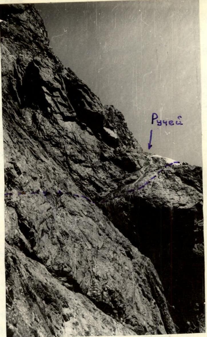 Fig. 8. End of section R23 — transition into the cirque
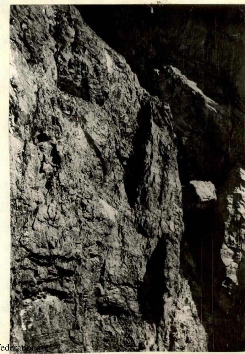 Fig. 7. View from section R19 onto the plug in the gully.
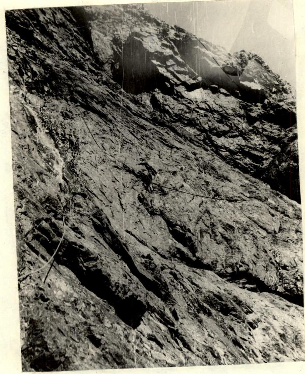 Fig. 9. Section R23. Traverse rightwards towards the gully.


