2170 73
Order No. 582, clause 34, January 26, 1988
Route Description
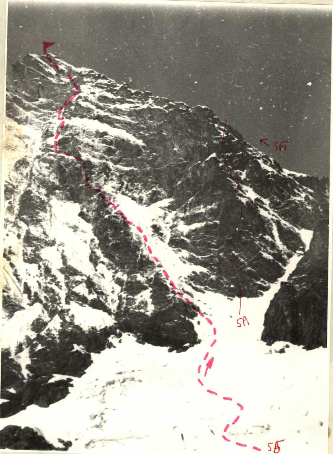
- to Mt. Dombay (Main) via the Northeast face, category 5B. By A. Ovchinnikov, 56.
Western Caucasus from Marukh pass to Nakhar pass
Description of the ascent route to Mt. Dombay Main via the Northeast face, category 5B
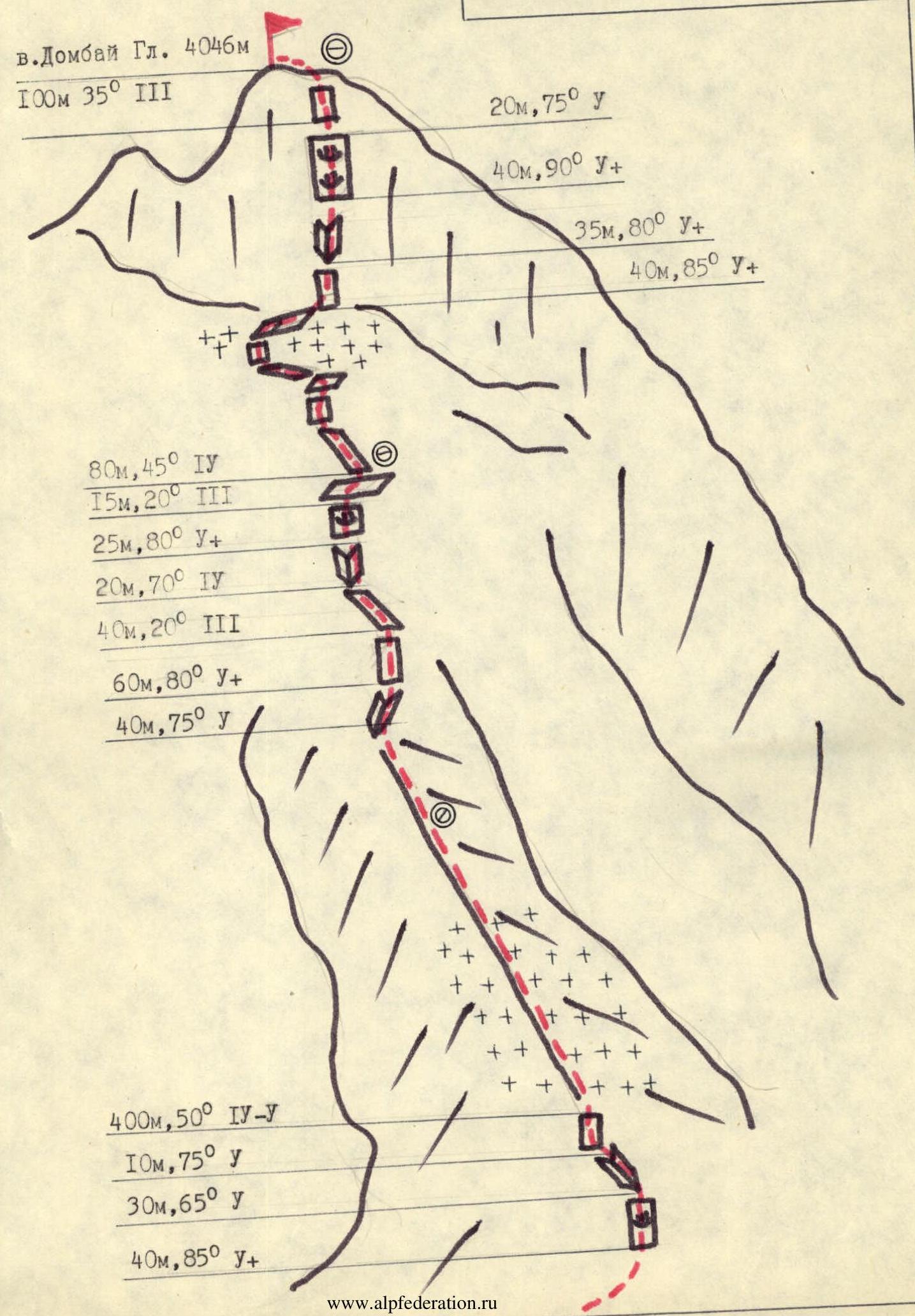
From Dombay clearing, follow the trail to Chuchkhur waterfalls and further to Chuchkhur pass. From the pass, traverse right along the northeastern slopes of Mt. Dombay Small and Mt. Dombay Main, and exit under the Eastern ridge of Dombay Main. Bivouac. From Dombay clearing — 5–6 hours.
From the bivouac, first along the eastern ridge for 100–120 m, and then along the northeastern slope of Mt. Dombay Small across the glacier and, further, through the bergschrund, exit under the northeastern face of Mt. Dombay Main. From the bivouac — 2–3 hours (depending on the glacier condition).
From the glacier, ascend 40 m to the right-upwards along the slab-like rocks (monolith) of the face to an internal angle. Ascend left-upwards through the internal angle to a 10-meter wall. Exit onto the counterfort via difficult rocks of the wall. There are sufficient places for organizing belay.
Ascend 400 m along the wet monolithic rocks of the counterfort (rock is slab-like, smooth, with few cracks) towards the base of the face (lower half of the counterfort is covered with ice and snow. Crampons are desirable!). In the upper part of the counterfort, a place for an overnight stay can be found. Further, ascend 20 m right-upwards through the internal angle, and then 60 m along difficult and very difficult rocks to an inclined talus shelf (live rocks!). Traverse left along the shelf to the outer angle and ascend along it to a wall.
The 25-meter wall with a 3-meter overhang in the middle leads to an inclined talus shelf. A place for a bivouac. From the start of the counterfort — 12–14 hours.
Further, traverse along the shelf with small walls through a 80-meter snow-ice belt, which is ascended in its left part, and exit under a steep wall. Ascend 40 m straight up the wall, and then 30 m along a monolithic internal angle towards another wall. Ascend left-upwards along the wall through a 2-meter overhang, then 40 m right-upwards through a 3-meter overhang, and 25 m along easier rocks to the ridge. Ascend 100 m left-upwards along the ridge to the summit. From the bivouac on the talus shelf — 7–9 hours.
Descend from the summit via the route of category 3B.
Recommendations for climbers:
- Group size — 4 people
- Ropes — 4 × 40 m
- Pitons, nuts — 30–40 pieces
- Initial bivouac — on the eastern ridge of Mt. Dombay-Ulgen Main.
Ascent route to Mt. Dombay-Ulgen Main via the Northeast face, category 5B
Mt. Dombay Main 4046 m 100 m, 35° 3 20 m, 75° 5 40 m, 90° 5+ 35 m, 80° 5+ 40 m, 85° 5+ 80 m, 45° 4 15 m, 20° 3 25 m, 80° 5+ 20 m, 70° 4 40 m, 20° 3 60 m, 80° 5+ 40 m, 75° 5 400 m, 50° 4–5 10 m, 75° 5 30 m, 65° 5 40 m, 85° 5+