 № 582 p.34 January 26, 1988
72
ROUTE DESCRIPTION
- to Mt. Dombay/Gl./ via North face 5A cat. diff. V. Budanov, 38
Western Caucasus from Marukh pass to Nakhar pass
DESCRIPTION
Ascent to Mt. Dombay-Ulgen Main via North face 5A cat. diff. From Dombay plain through Chuchkhur pass, then traverse right — exit under East ridge of Mt. Maly Dombay-Ulgen — bivouac. From Dombay plain — 5–6 hours.
From bivouac, first along the eastern ridge 190–120 m, then along the northeastern slope of Maly Dombay-Ulgen and through a bergschrund, exit under the northeastern wall of Mt. Glavny Dombay-Ulgen.
Further ascent up difficult rocks 60 m (rocks are smooth, with few cracks), then exit right onto a steep snowpatch (Rockfall hazard!!!).
The snowpatch is traversed right-up, and then up rocks of medium difficulty in the direction of a spalling. Near the spalling — a flat area, possible bivouac.
From the area, ascent up an internal corner 6 m, exit onto an inclined shelf with a crack 15–20 m.
Further:
- right 3–4 m along the internal corner — exit onto an inclined shelf under an overhang;
- The overhang is passed on the left-up along the wall 40 m on very difficult rocks using IT. Exit to a niche.
Ascent right of the niche:
- straight up 8–10 m onto an inclined shelf;
- along it, traverse right 10 m;
- then ascent up 50–60 m on difficult rocks onto a wide shelf.
Control point. Place for overnight stay.
From the wide shelf, ascent along an inclined slab right to an internal corner 20 m, and then up rocks above medium difficulty 80 m.
Excellent overnight stay for 3 tents.
Further on difficult rocks:
- ascent up the wall 40 m under an internal corner;
- along it, exit onto the North ridge behind the first ascent;
- along the ridge (path 3B cat. diff.) ascent to the summit.
Descent from the summit via path 3B cat. diff.
RECOMMENDATIONS FOR CLIMBERS
- Initial bivouac — eastern ridge of Maly Dombay-Ulgen.
- Special equipment — rope main — 2×40 m, rock pitons — 40 (including 10–15 "petal" type), nuts, ladders.
- Time breakdown:
- from initial bivouac to control point — 12–15 hours;
- from control point to exit onto North ridge — 10–12 hours;
- from exit onto ridge to summit — 3–4 hours.

ASCENT ROUTE TO MT. DOMBAY-ULGEN MAIN VIA NORTH FACE 5A CAT. DIFF.
 Control point
R16 20 m, 10° 2 R15 40 m, 35° 3 R14 15 m, 90° 5 R13 20 m, 50° 4 R12 50 m, 60° 4 R11 10 m, 90° 6 R10 20 m, 60° 6 R9 20 m, 80° 5 R8 10 m, 20° 3 R7 6 m, 80° 4 R6 40 m, 70° 4 R5 6 m, 20° 4 R4 60 m, 75° 4 R3 40 m, 60° 3+ R2 120 m, 45° 3 R1 60 m, 80–90° 5 R0 150–200 m, 4
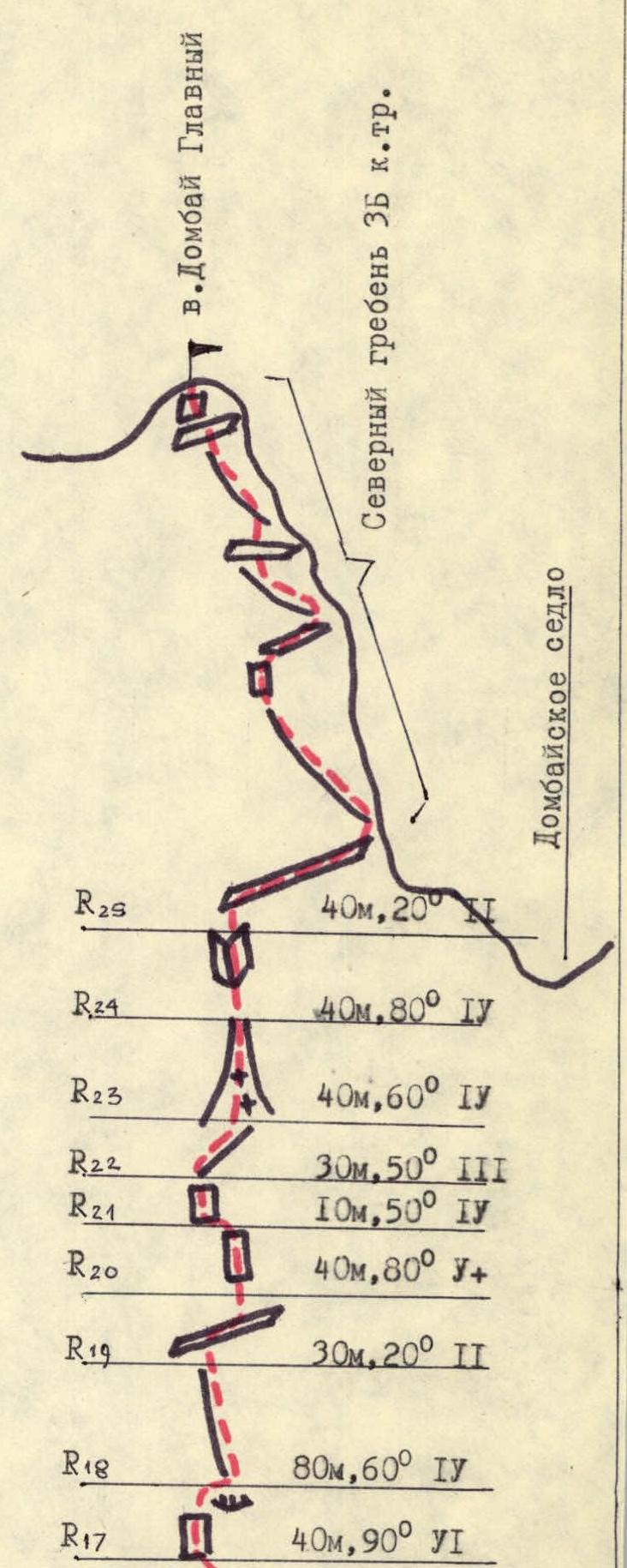
Mt. Dombay Main North ridge 3B cat. diff. Dombay saddle
R25 40 m, 20° 2 R24 40 m, 80° 4 R23 40 m, 60° 4 R22 30 m, 50° 3 R21 10 m, 50° 4 R20 40 m, 80° 5+ R19 30 m, 20° 2 R18 80 m, 60° 4 R17 40 m, 90° 6


