PASSPORT
- Class — rock
- Western Caucasus from Marukh pass to Nakhar pass.
- Peak Dombay Eastern, 3950 m, via the Centre of the North wall.
- Proposed difficulty category — 6.
- Height difference: 1350 m, length 1905 m, length of sections 5–6 cat. diff. — 850 m, average steepness of the main part of the route 63° (2600–3923 m), of which 5–6 cat. diff. (2600–3400 m) — 68°.
- Pitons driven:
| Rock | Bolts | Nuts | Ice screws |
|---|---|---|---|
| 169 | 4 | 109 | 1 |
| 21 | 3 | 12 | 0 |
-
Team's man-hours — 47 and days — 4.
-
Overnights:
- 3 lying on 4 people
- 1 lying on 3 people
-
Leader: Andryushchenko Anatoly Viktorovich — Master of Sports of the USSR
Participants:
- Nedelkin Vladimir Ilyich — Candidate Master of Sports
- Chuenko Sergey Anatolyevich — Candidate Master of Sports
- Rogachev Evgeny Anatolyevich — Candidate Master of Sports
-
Coach: Andryushchenko Anatoly Viktorovich
-
Approach to the route: August 7, 1983
Summit: August 10, 1983 Return: August 12, 1983
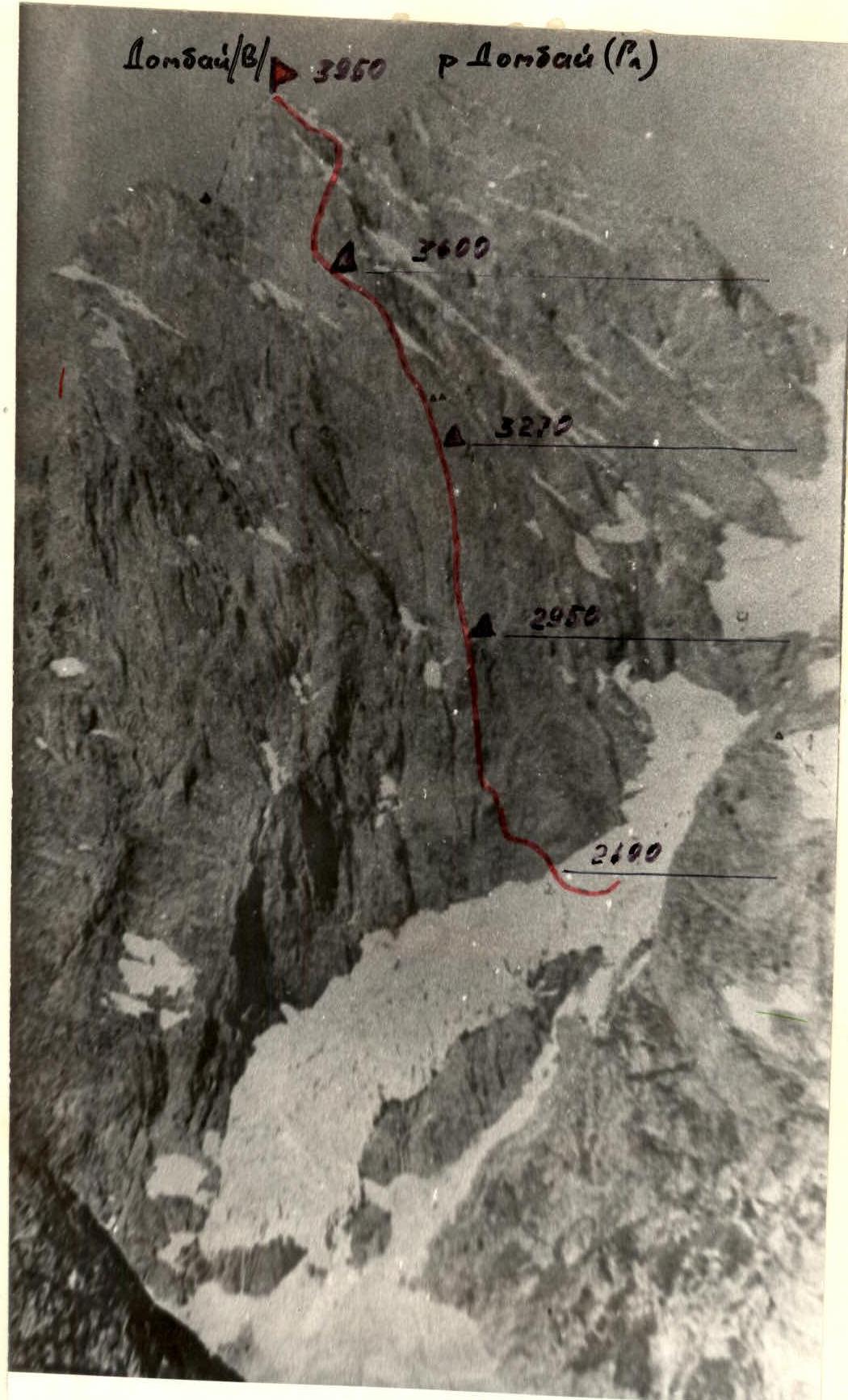

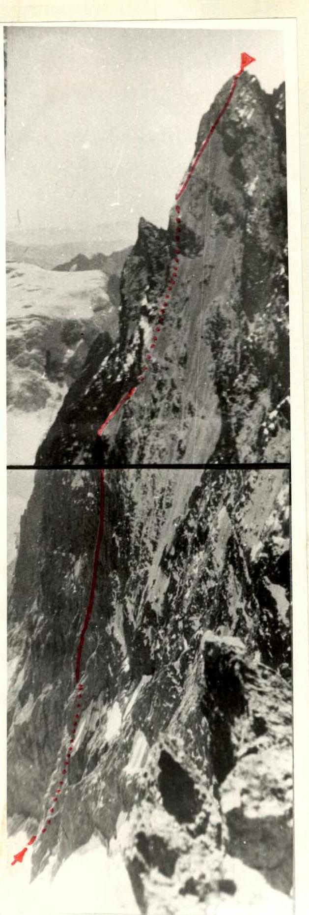
 General view of the peak — Route to v. Dombay (V) via the North wall (Gubanova).
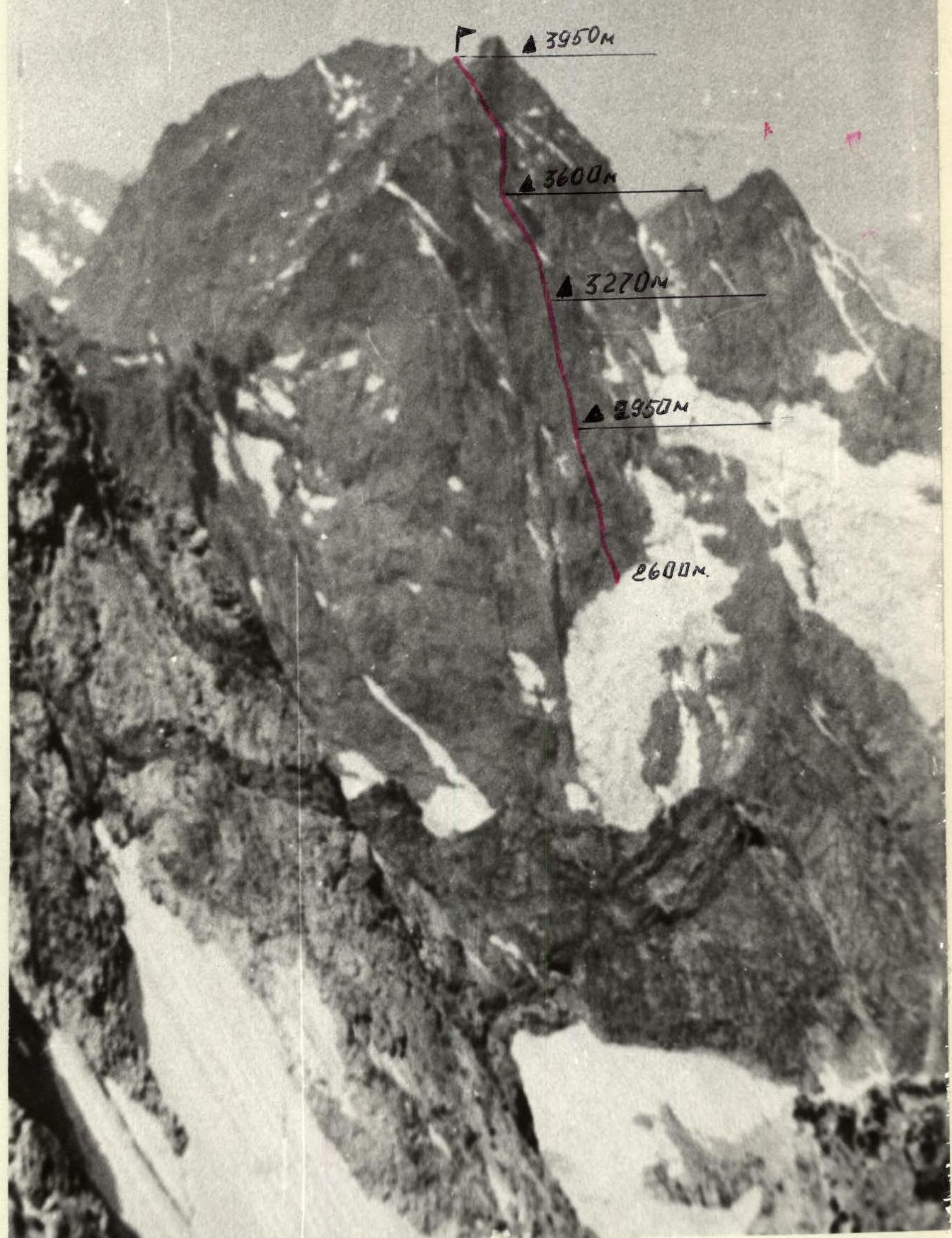 Profile of the wall on the left.
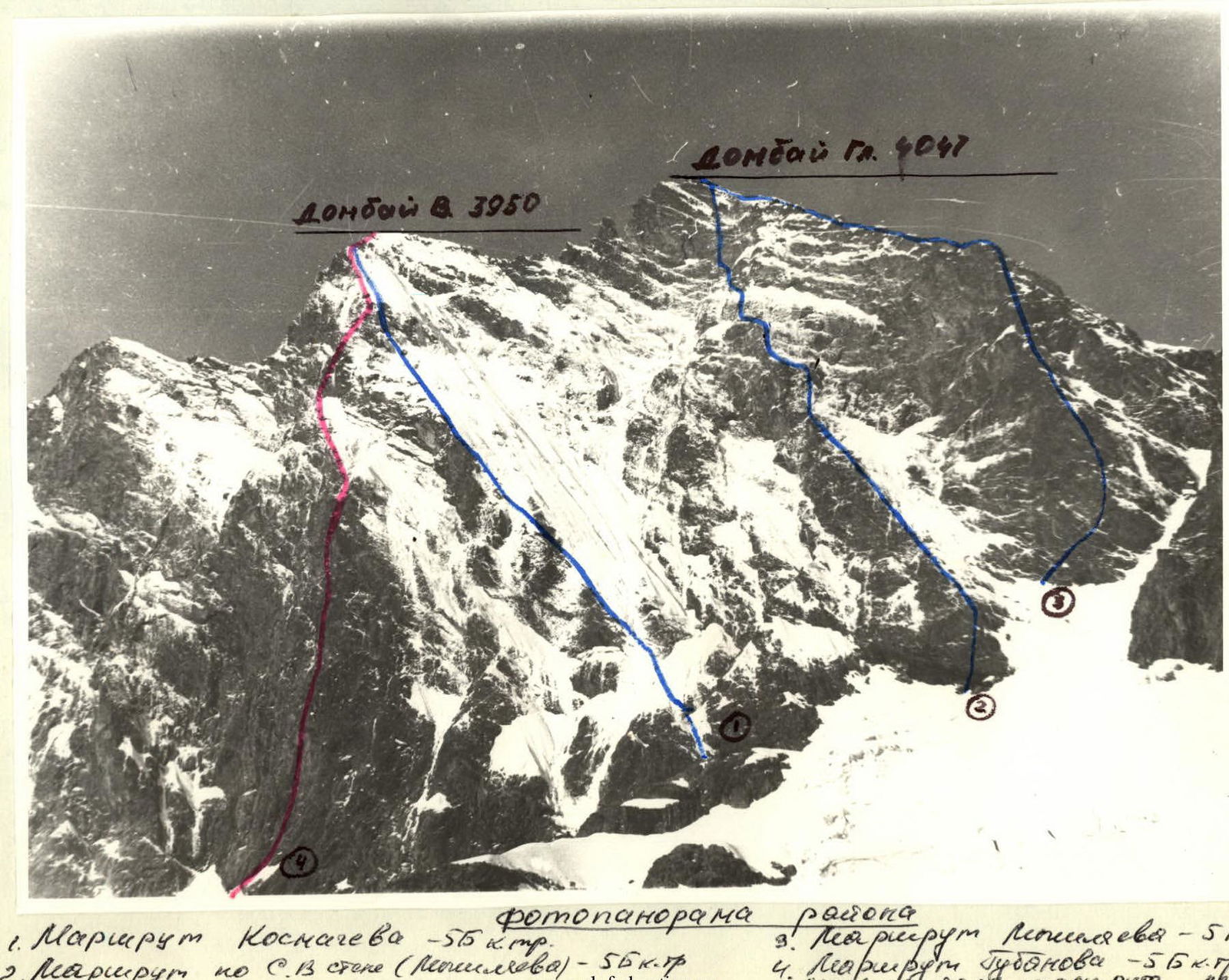
Photopanorama of the area:
- Kosmachev's Route – 5B cat. diff.
- Route via the North-East wall (Nechaev) – 5B cat. diff.
- Moiseev's Route – 5A cat. diff.
- Gubanov's Route – 5B cat. diff. (right part of B. Abalakova's route).
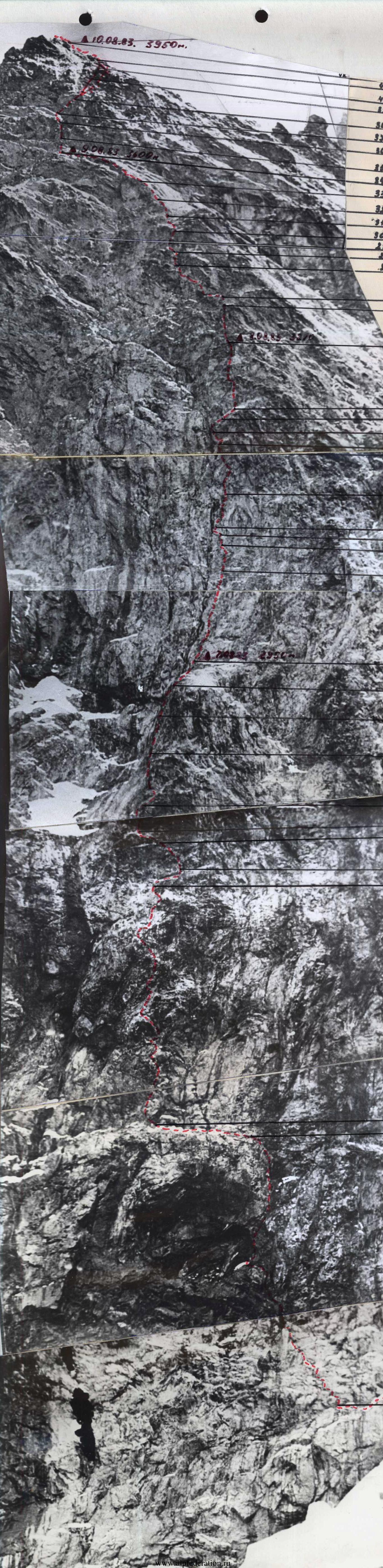
 Profile of v. Dombay (V) on the right.
— Visible part of the route.
.... Invisible part of the route.
Profile of v. Dombay (V) on the right.
— Visible part of the route.
.... Invisible part of the route.
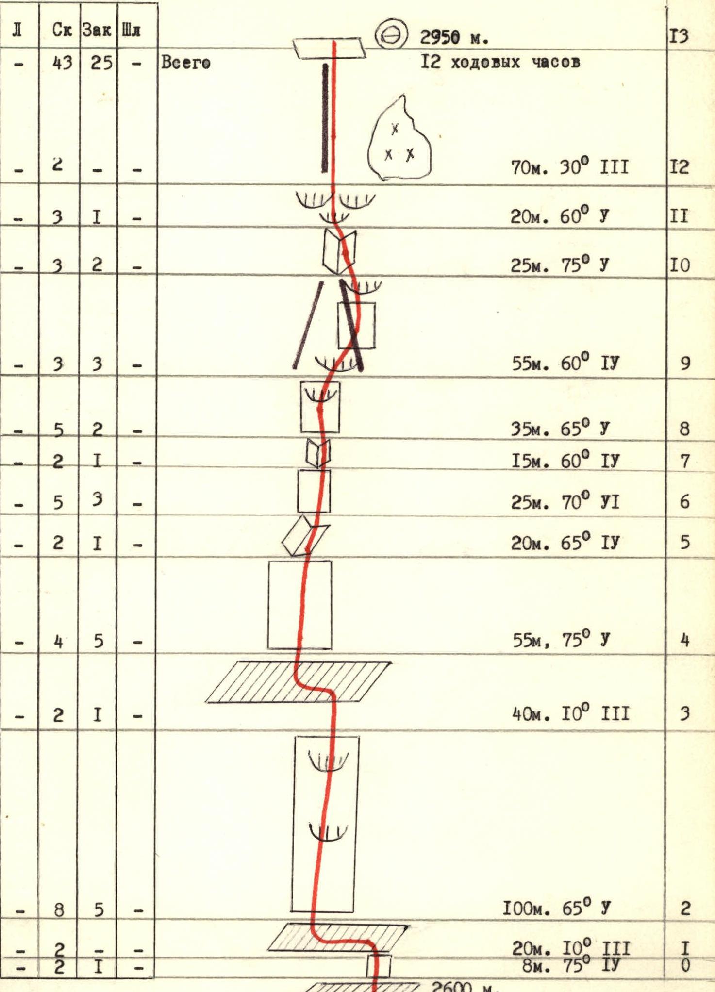 Piton table. Sheet 8. Section R0–R13 (2600–2950 m).
Scheme of the route to v. Dombay/V/ via the centre of the North wall in UIAA symbols. Scale 1:2000.
Piton table. Sheet 8. Section R0–R13 (2600–2950 m).
Scheme of the route to v. Dombay/V/ via the centre of the North wall in UIAA symbols. Scale 1:2000.
| Section | Ice screws | Rock pitons | Nuts | Bolts | Meters | Angle | Category |
|---|---|---|---|---|---|---|---|
| Total | - | 43 | 25 | - | 2950 m | ||
| R0 | - | - | - | - | 8 m | 75° | II |
| R1 | - | 8 | 5 | - | 20 m | 10° | III |
| R2 | - | 8 | 5 | - | 100 m | 65° | V |
| R3 | - | 2 | 1 | - | 40 m | 10° | III |
| R4 | - | 4 | 5 | - | 55 m | 75° | V |
| R5 | - | 2 | 1 | - | 20 m | 65° | IV |
| R6 | - | 5 | 3 | - | 25 m | 70° | VI |
| R7 | - | 2 | 1 | - | 15 m | 60° | IV |
| R8 | - | 5 | 2 | - | 35 m | 65° | V |
| R9 | - | 3 | 3 | - | 55 m | 60° | IV |
| R10 | - | 3 | 2 | - | 25 m | 75° | V |
| R11 | - | 3 | 1 | - | 20 m | 60° | V |
| R12 | - | 2 | - | - | 70 m | 30° | III |
| R13 | - | - | - | - | 2950 m | (12 man-hours) |
 Piton table. Sheet 8a. Section R13–R30 (2950–3270 m).
| Section | Ice screws | Rock pitons | Nuts | Bolts | Meters | Angle | Category |
|---|---|---|---|---|---|---|---|
| R13 | 12 | 4 | - | - | 90 m | 75° | V+ |
| R14 | - | 3 | 1 | - | 20 m | 75° | V |
| R15 | - | 2 | 1 | - | 10 m | 95° | V+ |
| R16 | - | 1 | 1 | - | 10 m | 10° | IV |
| R17 | 1 | 10/82/2 | 1/1 | 37 m | 90° | VI | |
| R18 | - | 7/4 | 3/2 | - | 40 m | 95° | VI |
| R19 | - | 2/1 | 1/1 | 2/2 | 8 m | 100° | VI+ |
| R20 | - | 3 | 1 | - | 30 m | 45° | IV |
| R21 | - | 2 | 1 | - | 20 m | 75° | V |
| R22 | - | 2 | 1 | - | 15 m | 20° | III |
| R23 | - | 10 | 4 | - | 75 m | 70° | V |
| R24 | 1 | 47/13 | 3/3 | 16/5 | 3270 m | (14 man-hours) | |
| R25 | - | 4/2 | 1/1 | - | 6 m | 95° | VI |
| R26 | - | 4 | 3 | - | 40 m | 80° | V+ |
| R27 | - | 2 | 3 | - | 40 m | 45° | IV |
| R28 | - | 1 | 2 | - | 20 m | 10° | V |
| R29 | - | 4/3 | 4/4 | - | 20 m | 90° | VI |
| R30 | - | - | - | - |
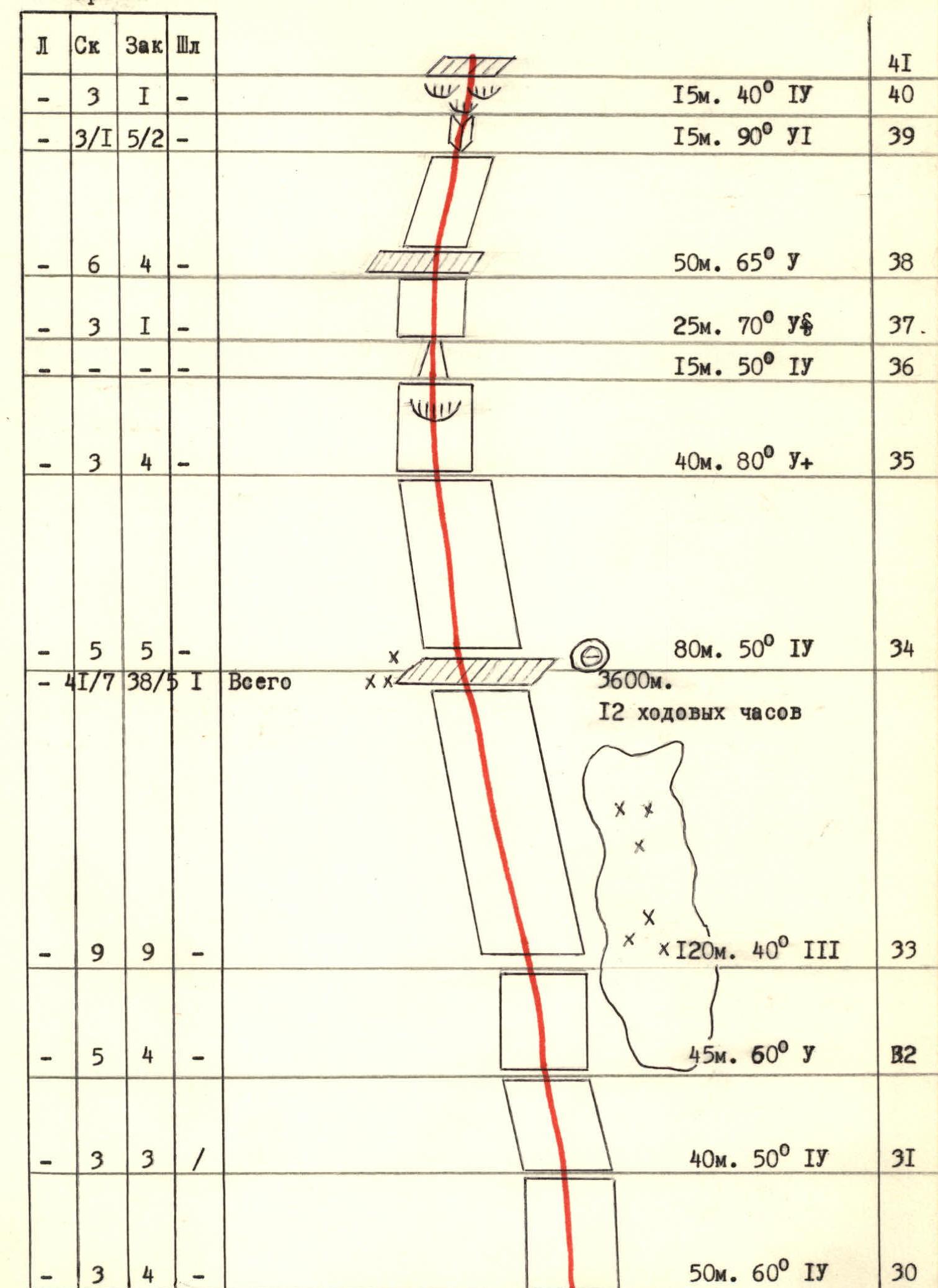 Piton table. Sheet 8b. Section R30–R41 (3270–3600 m).
| Section | Ice screws | Rock pitons | Nuts | Bolts | Meters | Angle | Category |
|---|---|---|---|---|---|---|---|
| R30 | - | 3 | 4 | - | 50 m | 60° | IV |
| R31 | - | 3 | 3 | - | 40 m | 50° | IV |
| R32 | - | 5 | 4 | - | 45 m | 60° | V |
| R33 | - | 9 | 9 | - | 120 m | 40° | III |
| R34 | - | 5 | 5 | - | 80 m | 50° | IV |
| Total | 41/7 | 38/5 | 1 | - | 3600 m | (12 man-hours) | |
| R35 | - | 3 | 4 - | 40 m | 80° | V+ | |
| R36 | - | - | - | - | 15 m | 50° | IV |
| R37 | - | 3 | 1 | - | 25 m | 70° | V |
| R38 | - | 6 | 4 | - | 50 m | 65° | V |
| R39 | - | 3/1 | 5/2 | - | 15 m | 90° | VI |
| R40 | - | 3 | 1 | - | 15 m | 40° | IV |
| R41 | - | - | - | - |
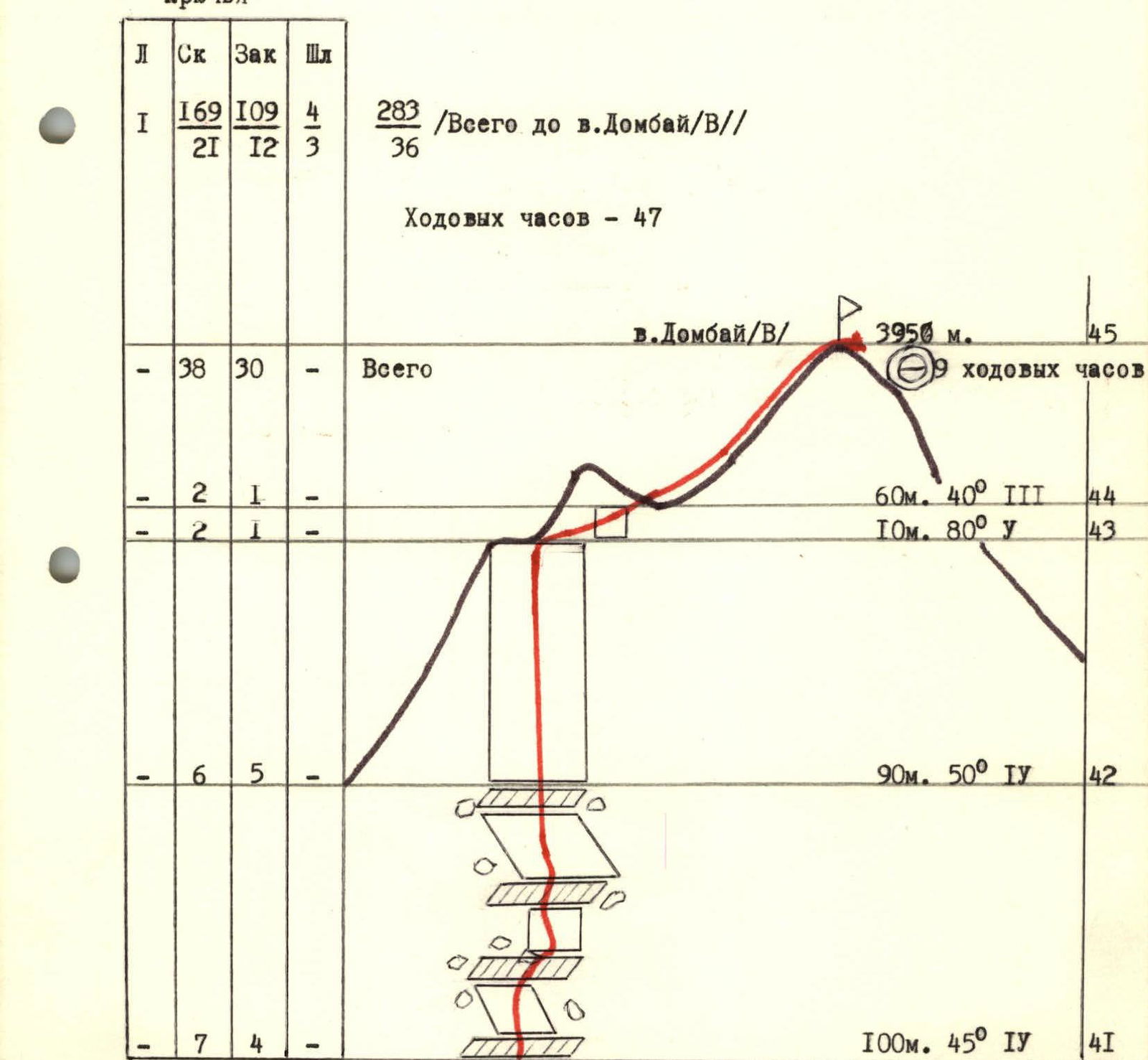 Piton table. Sheet 8b. Section R41–R45 (3600–3950 m) and total.
| Section | Ice screws | Rock pitons | Nuts | Bolts | Meters | Angle | Category |
|---|---|---|---|---|---|---|---|
| R41 | - | 7 | 4 | - | 100 m | 45° | IV |
| R42 | - | 6 | 5 | - | 90 m | 50° | IV |
| R43 | - | 2 | 1 | - | 10 m | 80° | V |
| R44 | - | 2 | 1 | - | 60 m | 40° | III |
| R45 | - | - | - | - | 3950 m | (9 man-hours) | |
| Total to v. Dombay/V/ | 1 | 169 | 109 | 4 | 36 | (47 man-hours) | |
| Total on the scheme | 0 | 21 | 12 | 3 |
Description of the route by sections
From the glacier, exit to the shelf via an 8-meter monolithic wall. Convenient place for belaying.
Along the scree shelf left 20 m, and then straight up the monolithic rocks, to the right of the strongly overhanging rusty rocks, 100 m, to the internal corner (in the second half of the day, water flows through it). In the middle and upper parts, there are two overhanging sections of 2–3 meters. There are enough places for belaying. Along the monolithic rocks of the internal corner, right-upwards to the sloping scree shelf. Rocks like "sheep's foreheads". Along the simple rocks of the shelf, left to a vaguely expressed external corner. (Rockfall possible). Along its left side, straight up, bypassing a 2-meter overhang on the left, 55 m to the internal corner and along it to the steep wall. Along very complex rocks, left-upwards to the internal corner. Along the monolithic rocks of the internal corner, right-upwards to the wall. Along the 35-meter wall, right-upwards through the overhang to the base of the wide couloir. Along the right side of the couloir, along slab-like rocks through two overhanging sections, enter the internal corner. Along the internal corner, then straight up the wall with overhanging sections, but with good holds — exit to the ridge, resting against the central wall. Along the left side of the ridge, along a snowfield in the form of a "tent" — exit to a site for a bivouac. 1st control point. Almost throughout the lower part of the wall, there are enough cracks for belaying. Many places for using nuts. The first one moved with a lightened backpack on a double rope. The rest climbed along the top rope using jammers with top belay. Andryushchenko A.V. worked first. Rucksack extraction and change of lead were not carried out, nor was the order of movement of the remaining team members changed.
From the overnight stay, 5 m left-upwards along simple rocks, and then along smoothed rocks straight up along a large internal corner 90 m, under overhanging rocks. Rocks with few holds and cracks for pitons. The overhang is bypassed on the left along the internal corner. Further along the overhanging rocks with good holds and in the upper part with a crack — exit to a narrow shelf. Sitting overnight stay possible. Further along the description, there is a bolt route (protrusions are cut off), but on the left, a passage along the internal corner is possible, where all previous groups passed. Climbing is very difficult with the use of ITO and organization of a pendulum. The last 30 m are passed by free climbing. Belaying place — for one person.
Further along very complex monolithic, overhanging rocks throughout the 40-meter section — exit under a 100° in an 8-meter gap with bolt pitons. Along the gap using previously driven bolt pitons and nuts — exit to inclined slabs. Both of these overhanging sections are passed using ITO. The first one climbed without a backpack. Along the slabs, left-upwards to the crack. Along complex rocks of the crack — exit to a shelf and along the shelf, right-upwards (live rocks!) under the wall. Convenient place for belaying. Along steep and heavily destroyed rocks of the wall (live rocks!) 70 m straight up to the bivouac site. Lead change was not carried out.
From the bivouac, left-upwards along smoothed rocks with few holds and cracks under a 10-meter overhanging wall. (ITO, the first one goes without a backpack). Convenient area for belaying.
Passage of the route:
- Through a 6-meter overhang — exit to a wide internal corner.
- Along the right wall of the corner — exit to a sloping internal corner to the left.
- Along the sloping corner — to a narrow shelf. Convenient belaying place.
- Along the narrow sloping shelf under a 20-meter overhang — to a sheer wall, turning into an internal corner in the upper part.
The passage is very difficult. The upper half is passed using ITO. The first one without a backpack.
Further along slab-like rocks — exit to the "Edge". Rockfall from the roof possible.
Along the edge, 5 ropes along rocks above average difficulty — exit to a bivouac under the pre-summit tower:
- Rocks are wet.
- There are many live rocks on the shelves.
Bivouac under an overhanging wall. Chuenko S.A. worked first. Lead change was not carried out.
From the bivouac, left-upwards along a pronounced sloping shelf, two ropes under a 40-meter wall. Rocks are wet from water flowing from the "roof" and bad weather. Along wet and complex rocks straight up into the couloir filled with snow. From the couloir, right-upwards, two ropes along difficult rocks under a 15-meter sheer internal corner (ITO). Along the internal corner, and then along snow-covered rocks above average difficulty — exit to an indistinct counterfort. Along snow-covered rocks with scree shelves 100 m, and then 90 m along slab-like rocks with snow sections — exit to the ridge 5B cat. diff. under the giant. Along a 10-meter wall — exit to a simple summit ridge. Along its left side 60–80 m to the summit.
Rogachev E.A. worked first. Lead change was not carried out.


