Central Council of the Student Voluntary Sports Society "Burevestnik"
Report
on the ascent to the summit of East Dombay-Ulgen via the center of the north wall
Team of the "Alibek" alpine camp
Team captain — Gubanov Yu.D. Team coach — Beletsky E.A.
71
Information about team members
| № | Last name, first name, patronymic | Year of birth | Profession | Alpine qualification | Alpine experience | Home address |
|---|---|---|---|---|---|---|
| 1 | GUBANOV Yuri Dmitrievich | 1937 | operator | CMS | 12 | Dombay. Pikhovyy Mys, d. 24, kv. 2 |
| 2 | GABELASHVILI Valery Karpovich | 1933 | teacher | MS | 21 | Georgian SSR, Kutaisi, Gogebashvili str. 4, lane № 1 |
| 3 | CHASOV Eduard Izrailevich | 1932 | engineer | CMS | 15 | Leningrad, D-104, Liteyny pr., 43, kv. 10 |
| 4 | AGANISYAN Eduard Aramovich | 1940 | engineer | CMS | 15 | Leningrad, F-2, Fontanka, 50, kv. 63 |
| 5 | PERKOVSKY Lev Ignatievich | 1928 | engineer | CMS | 18 | Leningrad, P-46, Kuibyshev str. 10–21 |
| 6 | BAKURSKY Leonid Alekseyevich | 1937 | engineer | MS | 18 | Leningrad, K-9, Lebedev str., 20, kv. 16 |
| Observation group | ||||||
| 1 | DEMIDOV Viktor Vasilyevich | 1949 | student | III | 4 | Leningrad, LETI dormitory |
| 2 | STEPANOV Boris Grigoryevich | 1950 | student | III | 4 | Leningrad, LETI dormitory |
1. Characteristics of the ascent route
The route can be divided into four parts, varying in complexity and requiring specific tactics for passage (Fig. 1).
The lower wall — from the glacier to the shoulder with a snowfield, corresponds in length and complexity to the 5B category route type Myshlyaev on Main Dombay. The length along the ropes is 590 m, height is 465 m, and the average steepness is 60°.
The central wall is sheer (even overhanging) in the lower half and very steep in the upper half. It is formed from very smooth monolithic rocks, partly covered with lichen (very slippery) with a small number of cracks. Its technical difficulty corresponds to the complexity of 6B category routes. The wall length is 553 m, height is 517 m, and steepness is 77°.
The edge, which is the boundary between the wall and the slopes descending from the summit, is composed of rocks with a complexity corresponding to the usual 5A–5B category route. The edge length is 306 m, height is 262 m, and steepness is 62°.
The summit tower consists of two sheer walls and an upper ice (in normal years) pre-summit slab. The rocks here also correspond to the complexity of a 5B category route. Its length is 540 m, height is 440 m, and steepness is 58°.
The route leads either directly to the summit or to the eastern ridge — to the standard 5B category route — 40–70 m from the summit (there is no technical difference in their complexity). The descent is made along the usual 5B category route ("East Dombay via the South wall") followed by a traverse through the Dombay pass.
The division of the route into parts and their subdivision into sections, as well as the main data on the route, are given in Fig. 1. Figures 2–5 show profiles of the summit by parts, and Fig. 6 shows the overall profile of the ascent route.
As already mentioned, the exact height of the wall has not been precisely established. According to Kosmachev — Struk, it is 1900 m (although their route starts 200–250 m above the described one). According to our altimeter measurements (three measurements), its height is 1500 m, and according to the profile schemes given in the text, it is 1684 m. However, the latter value is inaccurate as it includes route lengthening due to deviation from the vertical. The estimated deviation is 10%, so the wall height according to the maps is 1615 m. Apparently, until more accurate measurements are made, the wall height should be considered to be 1500 m.
The route thread runs practically along the vertical dropped down from the summit. The passed route completely coincides with the declared one. Along the Central wall, movement was conducted 10–30 m to the right of the indicated route, as the black vertical strip, taken during observation for a crack, turned out to be actually a wet, sometimes watery, part of the overall wall, which is potentially rockfall-prone (although the group did not notice any rockfalls). The group came out onto it once over a distance of several meters.
Night camps (except for the hanging one) were organized in convenient and safe places, and their location coincided with the expected ones. There are several more places suitable for organizing night camps (indicated in the table and text). It should be taken into account that preparing a platform for a tent requires 4–6 hours of daylight.
The main characteristics of the route are summarized in the "Table of main characteristics," placed in section IV.
7. Table of main characteristics of the ascent route
Ascent route — East Dombay-Ulgen summit via the center of the north wall.
Route elevation gain — about 1500 m. Elevation gain of the most difficult sections — 475 m. Route steepness — 65°. Steepness of the most difficult sections — 83°. Number of rock pitons driven — 379, bolt pitons — 26, including at bivouacs — 40/3.
Ice pitons — 1. Specific information on sections is given in tables 4–5. Photographs of the overall wall view, a telephoto shot of the wall, and photographs characterizing the route and the technique of its passage are placed at the end of the report after the text material.
Section maps are included in the appendix to the report.
Main characteristics of the ascent route
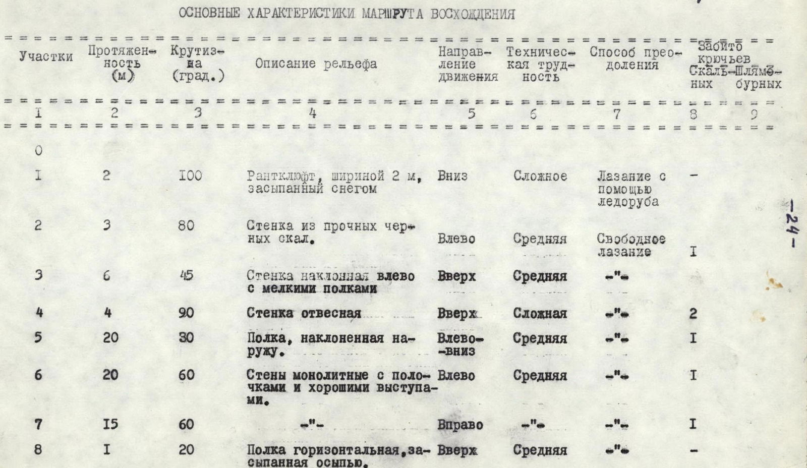
| Sections | Length (m) | Steepness (deg.) | Relief description | Direction of movement | Technical difficulty | Method of overcoming | Rock pitons driven | Bolt pitons |
|---|---|---|---|---|---|---|---|---|
| 0 | ||||||||
| 1 | 2 | 100 | Rime-clogged narrow ledge, 2 m wide, filled with snow | Down | Difficult | Climbing with the help of an ice axe | ||
| 2 | 3 | 80 | Wall of strong black rocks | Left | Average | Free climbing | 1 | |
| 3 | 6 | 45 | Inclined wall with small ledges | Up | Average | "-" | ||
| 4 | 4 | 90 | Sheer wall | Up | Difficult | "-" | 2 | |
| 5 | 20 | 30 | Outward-sloping ledge | Left-down | Average | "-" | 1 | |
| 6 | 20 | 60 | Monolithic walls with small ledges and good protrusions | Left | Average | "-" | 1 | |
| 7 | 15 | 60 | "-" | Right | "-" | "-" | 1 | |
| 8 | 1 | 20 | Horizontal ledge, filled with scree | Up | Average | "-" | ||
| 9 | 30 | 70 | Monolithic black wall with cracks | Up | Average | Free climbing | 1 | |
| 10 | 3 | 110 | Overhanging wall, right — crack | Up | Very difficult | Climbing with the help of a ladder (1 time) | 1 | |
| 11 | 8 | 50 | Inner corner, at the end — inclined slab | Left | Difficult | Climbing with the use of a ladder | ||
| 12 | 5 | 100 | Overhanging slab to the right of the inner corner | Up | Very difficult | Climbing with the use of a ladder (5 times) | 7 | |
| 13 | 8 | 60 | Outward-sloping ledge of smooth slabs | Left | Average difficulty | Free climbing | 1 | |
| 14 | 5 | 30 | Ledges covered with reddish scree | Right | Easy | "-" | 1 | |
| 15 | 15 | 80 | Rocks in the form of two outer corners, reddish, partly destroyed | Right | Difficult and very difficult | Free climbing with ladders (2 times) | 5 | |
| 16 | 18 | 60 | Inner corner, left — sheer slab, right — smooth "ram's foreheads," inclined outward | Right | Difficult | Free climbing | 2 | |
| 17 | 5 | 80 | Gray simple wall, at the end — sheer | Up | Difficult | "-" | 1 | |
| 18 | 15 | 60 | Black monolithic rocks with good protrusions | Up | Average difficulty | "-" | 1 | |
| 19 | 40 | 15 | Ledge 0.5–1.5 m wide, turning into a diamond-shaped platform 10×15 m, covered with scree (snowfield) | Left | Easy | Movement in a rope team | 1 | |
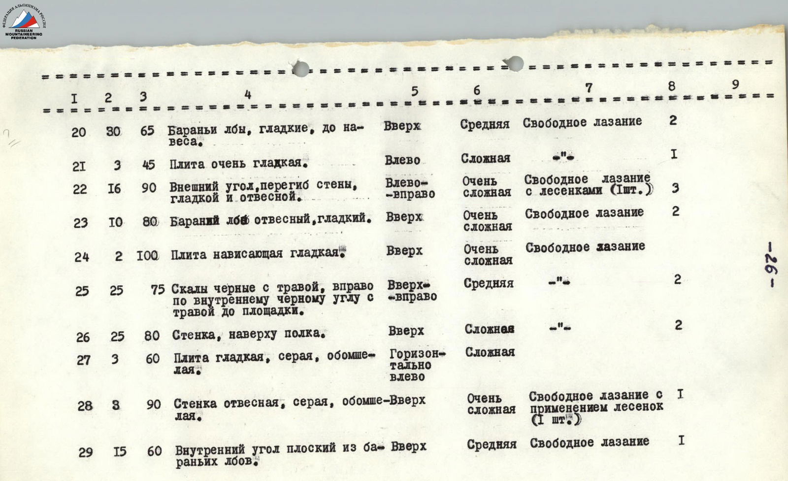
| 20 | 30 | 65 | "Ram's foreheads," smooth, up to an overhang | Up | Average | Free climbing | 2 | |
| 21 | 3 | 45 | Very smooth slab | Left | Difficult | "-" | 1 | |
| 22 | 16 | 90 | Outer corner, wall kink, smooth and sheer | Left-right | Very difficult | Free climbing with a ladder (1 pc.) | 3 | |
| 23 | 10 | 80 | Sheer, smooth "ram's forehead" | Up | Very difficult | Free climbing | 2 | |
| 24 | 2 | 100 | Overhanging smooth slab | Up | Very difficult | Free climbing | ||
| 25 | 25 | 75 | Black rocks with grass, up the inner black corner with grass to a platform | Up-right | Average | "-" | 2 | |
| 26 | 25 | 80 | Wall, at the top — ledge | Up | Difficult | "-" | 2 | |
| 27 | 3 | 60 | Smooth, gray, moss-covered slab | Horizontally left | Difficult | |||
| 28 | 3 | 90 | Sheer, gray, moss-covered wall | Up | Very difficult | Free climbing with the use of a ladder (1 pc.) | 1 | |
| 29 | 15 | 60 | Inner corner of flat "ram's foreheads" | Up | Average | Free climbing | 1 |
| Sections | Length (m) | Steepness (deg.) | Relief description | Direction of movement | Technical difficulty | Method of overcoming | Rock pitons driven | Bolt pitons |
|---|---|---|---|---|---|---|---|---|
| 30 | 10 | 40 | Outward-sloping ledge to the left | Left | Average | Free climbing | 2 | |
| 31 | 2 | 120 | Overhanging rock | Up | Difficult | "-" | 1 | |
| 32 | 6 | 20 | Horizontal smooth ledge | Left | Average | "-" | ||
| 33 | 13 | 50 | Slab, "ram's foreheads" | Up | Average | "-" | 1 | |
| 34 | 10 | 60 | Smooth slab | Left-up | Average | "-" | 1 | |
| 35 | 50 | 60 | "Ram's foreheads" and slabs of the right part of the couloir, right — wall kink | Left-up-right | Average | "-" | 4 | |
| 36 | 15 | 45 | Series of small platforms and ledges, convenient for group assembly | Right | Easy | "-" | 4 | |
| 37 | 30 | 80 | Rocky inner corner with grass, stepped, at the top — sheer, left — wall | Up | Difficult | Free climbing with the use of ladders (2 times) | 4 | |
| 38 | 8 | 45 | Crack left — up — right | Right | Average | Free climbing | 1 | |
| 39 | 12 | 70 | Flat ridge of "ram's foreheads" | Up | Average | "-" | 4 | |
| 40 | 80 | 40 | Wide ridge of "ram's foreheads," filled with scree, right — snowfield 15–18 m long | Up | Easy | "-" | 6 | |
| 41 | 45 | 80 | Light, ribbed, tile-like slab, turning into very smooth "ram's foreheads" | Up | Difficult | "-" | 9 |
| Sections | Length (m) | Steepness (deg.) | Relief description | Direction of movement | Technical difficulty | Method of overcoming | Rock pitons driven | Bolt pitons |
|---|---|---|---|---|---|---|---|---|
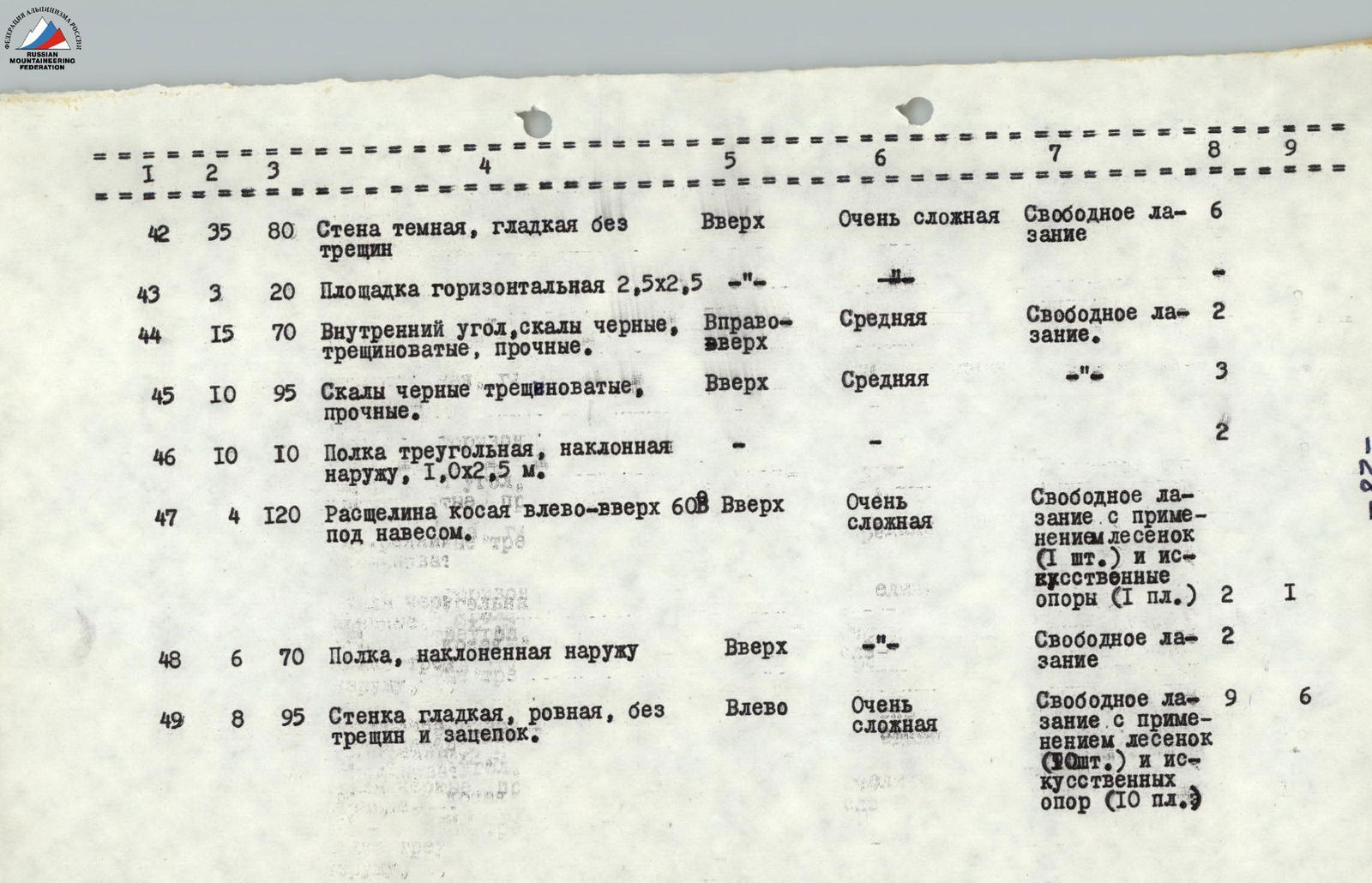
| 42 | 35 | 80 | Dark, smooth wall without cracks | Up | Very difficult | Free climbing | 6 | |
| 43 | 3 | 20 | Horizontal platform 2.5×2.5 | "-" | ||||
| 44 | 15 | 70 | Inner corner, black, cracked, strong rocks | Right-up | Average | Free climbing | 2 | |
| 45 | 10 | 95 | Black, cracked, strong rocks | Up | Average | "-" | 3 | |
| 46 | 10 | 10 | Triangular ledge, inclined outward, 1.0×2.5 m | "-" | 2 | |||
| 47 | 4 | 120 | Oblique crack left-up at 60° under an overhang | Up | Very difficult | Free climbing with the use of a ladder (1 pc.) and artificial aids (1 platform) | 2 | 1 |
| 48 | 6 | 70 | Outward-sloping ledge | Up | Free climbing | 2 | ||
| 49 | 8 | 95 | Smooth, even wall without cracks and footholds | Left | Very difficult | Free climbing with the use of ladders (10 pcs.) and artificial aids (10 platforms) | 6 |

| Sections | Length (m) | Steepness (deg.) | Relief description | Direction of movement | Technical difficulty | Method of overcoming | Rock pitons driven | Bolt pitons |
|---|---|---|---|---|---|---|---|---|
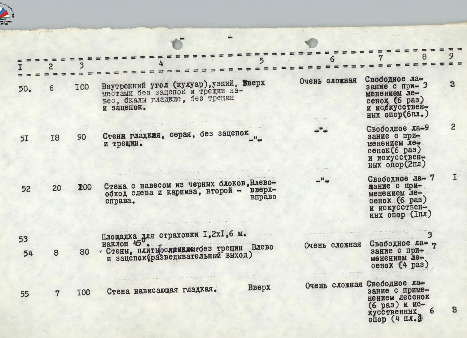
| 50 | 6 | 100 | Inner corner (couloir), narrow, partly without footholds and cracks, overhang, rocks smooth, without cracks and footholds | Up | Very difficult | Free climbing with the use of ladders (6 times) and artificial aids (6 platforms) | 3 | |
| 51 | 18 | 90 | Wall smooth, gray, without footholds and cracks | "-" | Free climbing with the use of ladders (6 times) and artificial aids (2 platforms) | 2 | ||
| 52 | 20 | 200 | Wall with an overhang of black blocks, bypass left and carniсe, second right | Left-up-right | "-" | Free climbing with the use of ladders (6 times) and artificial aids (1 platform) | 7 | |
| 53 | Platform for belaying 1.2×1.6 m, inclined 45° | 3 | ||||||
| 54 | 8 | 80 | Walls, slabs, rocks without cracks and footholds (reconnaissance exit) | Left | Very difficult | Free climbing with the use of ladders (4 times) | 7 | |
| 55 | 7 | 100 | Overhanging smooth wall | Up | Very difficult | Free climbing with the use of ladders (6 times) and artificial aids (4 platforms) | 3 |

| Sections | Length (m) | Steepness (deg.) | Relief description | Direction of movement | Technical difficulty | Method of overcoming | Rock pitons driven | Bolt pitons |
|---|---|---|---|---|---|---|---|---|
| 56 | 8 | 70 | Narrow inner corner with good footholds | Up-left | Average | Free climbing | 2 | |
| 57 | 20 | 45 | Smooth "ram's foreheads," inclined left 50° with mossy and grassy ledges (place of hanging night camp) | Left | Easy | Free climbing | For night camp, 20 rock and 3 bolt pitons driven | |
| 58 | 25 | 90 | Crack under the wall to the right, 10 cm wide, turning into a sheer chimney | Up | Difficult | "-" | 5 | |
| 59 | 10 | 30 | Ledge under "ram's foreheads," covered with scree | "-" | "-" | 3 | ||
| 60 | 60 | 85 | Stepped wall with overhangs, gray, of "ram's foreheads," smooth, without cracks and footholds, turning into reddish and black, extremely destroyed | Up | Very difficult | Free climbing with the use of ladders (5 times) and artificial aids (3 platforms) | 13 | |
| 61 | 30 | 70 | Rocks strongly destroyed and fragile | Up | Difficult | Free climbing | 3 | |
| 62 | 50 | Two ledges under "ram's foreheads," covered with scree (place for bivouac) | Left | Easy | 10 rock pitons for bivouac | |||
| 63 | 15 | 80 | Flat "ram's forehead" (slab), covered with lichen (inconvenient exit) without cracks and footholds | Up-left | Very difficult | Free climbing | 3 |
| Sections | Length (m) | Steepness (deg.) | Relief description | Direction of movement | Technical difficulty | Method of overcoming | Rock pitons driven | Bolt pitons |
|---|---|---|---|---|---|---|---|---|
| 64 | 8 | 0 | Horizontal crack of separate black boulders under an overhanging rock | Right | Difficult | Free climbing | 2 | |
| 65 | 15 | 80 | Sheer wall of destroyed rocks, turning into overhanging "ram's foreheads" | Up | Very difficult | Free climbing with the use of ladders (4 times) and artificial aids (2 platforms) | 9 | |
| 66 | 4 | 0 | Ledge under a gray wall, 0.1–0.5 m wide, inclined outward 40° (place for receiving backpacks) | Left | Easy | Free climbing | 3 | |
| 67 | 8 | 80 | Two overhanging rock ledges | Up | Difficult | Free climbing with the use of ladders (2 times) | 3 | |
| 68 | 6 | 0 | Horizontal ledge, 0.5–1.0 m wide | Left | Easy | Free climbing | 2 | |
| 69 | 10 | 95 | Sheer wall, smooth, gray, without any footholds | Up | Very difficult | Free climbing with the use of ladders (5 times) and artificial aids (4 platforms) | 6 | |
| 70 | 12 | 70 | "Ram's foreheads" with small, but well-fixed stones | Up | Average | Free climbing | 4 | |
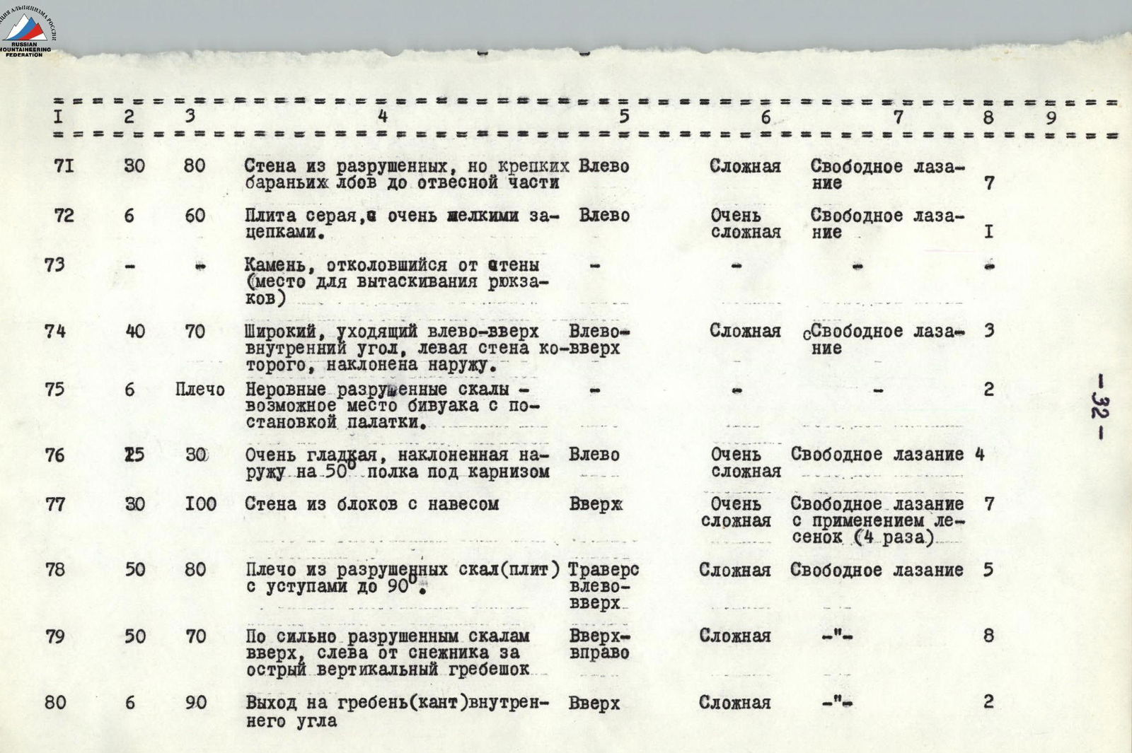
| 71 | 30 | 80 | Wall of destroyed, but strong "ram's foreheads" up to the sheer part | Left | Difficult | Free climbing | 7 | |
| 72 | 6 | 60 | Gray slab with very small footholds | Left | Very difficult | Free climbing | 1 | |
| 73 | - | - | Rock detached from the wall (place for pulling up backpacks) | - | - | - | - | |
| 74 | 40 | 70 | Wide inner corner, going left-up, left wall inclined outward | Left-up | Difficult | Free climbing | 3 | |
| 75 | 6 | Shoulder | Uneven destroyed rocks — possible bivouac site with tent setup | - | - | 2 | ||
| 76 | 25 | 30 | Very smooth, outward-sloping ledge under a carniсe | Left | Very difficult | Free climbing | 4 | |
| 77 | 30 | 100 | Wall of blocks with an overhang | Up | Very difficult | Free climbing with the use of ladders (4 times) | 7 | |
| 78 | 50 | 80 | Shoulder of destroyed rocks (slabs) with ledges up to 90° | Traverse left-up | Difficult | Free climbing | 5 | |
| 79 | 50 | 70 | Up along strongly destroyed rocks, left of a snowfield, behind a sharp vertical ridge | Up-right | Difficult | "-" | 8 | |
| 80 | 6 | 90 | Exit to the ridge (edge) of the inner corner | Up | Difficult | "-" | 2 |
| Sections | Length (m) | Steepness (deg.) | Relief description | Direction of movement | Technical difficulty | Method of overcoming | Rock pitons driven | Bolt pitons |
|---|---|---|---|---|---|---|---|---|
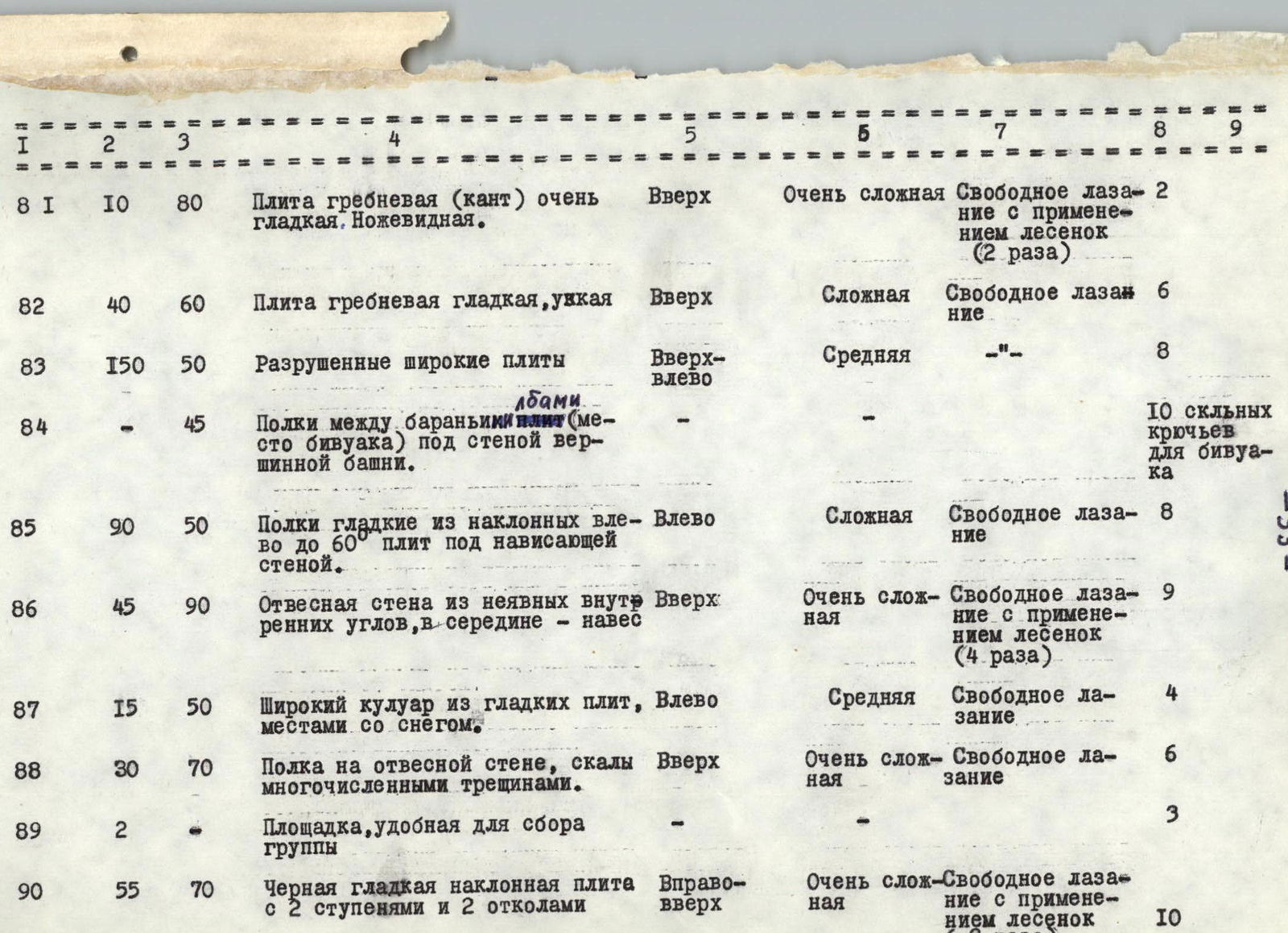
| 81 | 10 | 80 | Ridge slab (edge) very smooth. Knife-like | Up | Very difficult | Free climbing with the use of ladders (2 times) | 2 | |
| 82 | 40 | 60 | Ridge slab smooth, narrow | Up | Difficult | Free climbing | 6 | |
| 83 | 150 | 50 | Destroyed wide slabs | Up-left | Average | "-" | 8 | |
| 84 | - | 45 | Ledges between "ram's forehead" slabs (bivouac site) under the wall of the summit tower | "-" | "-" | 10 rock pitons for bivouac | ||
| 85 | 90 | 50 | Smooth ledges of inclined left up to 60° slabs under an overhanging wall | Left | Difficult | Free climbing | 8 | |
| 86 | 45 | 90 | Sheer wall of unclear inner corners, in the middle — overhang | Up | Very difficult | Free climbing with the use of ladders (4 times) | 9 | |
| 87 | 15 | 50 | Wide couloir of smooth slabs, partly with snow | Left | Average | Free climbing | 4 | |
| 88 | 30 | 70 | Ledge on a sheer wall, rocks with numerous cracks | Up | Very difficult | Free climbing | 6 | |
| 89 | 2 | - | Platform convenient for group assembly | "-" | 3 | |||
| 90 | 55 | 70 | Black smooth inclined slab with 2 steps and 2 cracks | Right-up | Very difficult | Free climbing with the use of ladders (3 times) | 10 |
| Sections | Length (m) | Steepness (deg.) | Relief description | Direction of movement | Technical difficulty | Method of overcoming | Rock pitons driven | Bolt pitons |
|---|---|---|---|---|---|---|---|---|
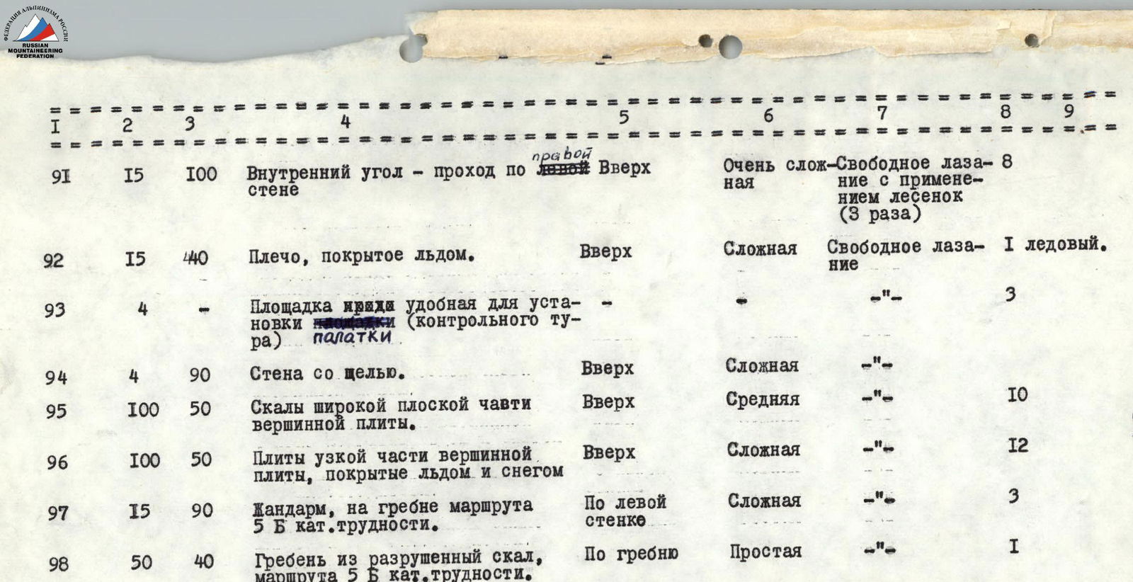
| 91 | 15 | 100 | Inner corner — passage along the right wall | Up | Very difficult | Free climbing with the use of ladders (3 times) | 8 | |
| 92 | 15 | 40 | Shoulder covered with ice | Up | Difficult | Free climbing | 1 ice piton | |
| 93 | 4 | - | Platform convenient for tent setup (control point) | Up | Difficult | "-" | 3 | |
| 94 | 4 | 90 | Wall with a slit | Up | Difficult | "-" | ||
| 95 | 100 | 50 | Rocks of the wide flat part of the summit slab | Up | Average | "-" | 10 | |
| 96 | 100 | 50 | Slabs of the narrow part of the summit slab, covered with ice and snow | Up | Difficult | "-" | 12 | |
| 97 | 15 | 90 | "Zhan-darm" on the ridge of the 5B category route | Along the left wall | Difficult | "-" | 3 | |
| 98 | 50 | 40 | Ridge of destroyed rocks, 5B category route. Exit to the summit | Along the ridge | Easy | "-" | 1 |
VI. Order of passage of the route
First day (August 1, 1971) — the group arrived by truck at about 19:00 with all their cargo in the Bu-Ulgen gorge, at the foot of the tourist camps on the descent from the Chuchkhr pass.
Second day (August 2) — one climber (2 people) made an ascent to the base camp site on the spur under the East Dombay wall. On the "ram's foreheads" of the rocky spur, permanent ropes were installed (12 pitons driven) for passage with a load and for the needs of observers. The base camp was equipped.
Third day (August 3) — the rope team consisting of Gubanov — Aganisyán processed the lower wall, passing most of it. After this team passed a long horizontal ledge (around 11 am), the rest of the command set out from the camp and lifted the public load (piton, carabiners, food, tents) almost to the place where the leading rope team had made its way.
Fourth day (August 4) — the group in full crossed the glacier (crampons, extra ice axes were left under the wall), the group reached the processed part of the route by 12:30, and then came out onto the shoulder under the central wall. Part of the group began to look for a safe place to set up a bivouac, while the rest lifted the equipment left from the previous day.
Fifth day (August 5) — processing of the key section began (Aganis Sidney — Bakurisky rope team), but bad weather did not allow full use of the daylight. At the end of the day, the Perkovsky — Chasov pair passed the processed section and brought pitons and other equipment.
The Gabelashvili — Perkovsky pair went 100 m up and to the right to scout the possibility of bypassing the overhang to the right. However, this path led to:
- loose, overhanging rocks,
- ledges of the right couloir,
- where rockfalls occur.
Sixth day (August 6) — Aganesyan and Bakursky passed the first bolt wall and 40 m of the wall. However, further work was hindered by bad weather.
Seventh day (August 7) — the group passed the previously processed part of the route, and then Perkovsky — Chasov processed the second bolt wall and hung ropes to a ledge where it is possible to set up a platform for a tent. However, the group and backpacks were significantly lower, and they had to spend the night on "ram's foreheads" under an overhanging wall. Three people slept in hammocks, the rest in a semi-reclining position on the ropes. There was a weak thunderstorm at night.
Eighth day (August 8) — they reached the ledge and built a platform for a tent and two "zdarkas" out of stones. This took about 5 hours and 30 minutes, as stones had to be lifted in backpacks from lower platforms.
During the 7th and 8th days, there was no water or snow anywhere. For 1 day, the group used a water reserve in flasks. The group was without water for about a day until a passing rain allowed them to collect about 4 liters of water.
In the afternoon:
- Chasov — Perkovsky passed the third bolt section;
- they approached the edge.
Ninth day (August 9)
- General movement upward
- The Aganisyán — Bakurisky rope team led the way on the further route
- As soon as the group approached the "ram's foreheads," a strong thunderstorm with snow broke out
- The platform was laid out over 4 hours
- Water was plentiful
Tenth day (August 10) — the sheer, icy rocks did not allow the group to start moving in the morning, so the Gubanov — Aganisyán rope team started processing only at 10:00 and, having passed about 100 m, was forced to return to the bivouac again. Almost immediately, a strong thunderstorm with hail broke out. From the bivouac, the path to the saddle under Main Dombay is visible. As we later found out, the group of the Lvovsky gathering, following us:
- reached the shoulder
- from there ascended to the summit.
VII. Evaluation of the route and the group's actions
Eleventh of August (August 11) — sunny weather facilitated the group's exit onto the route. The rocks quickly thawed. The Chasov — Perkovsky rope team passed the vertical walls and reached the ice on the pre-summit slab. Here, for the first time on the route, the entire load was transferred to backpacks, and further movement was made with backpacks. 200 m from the summit, a strong thunderstorm with snow and hail broke out. In one of the clearings during the thunderstorm, we saw a group on the 3B category route to the summit of Main Dombay and established voice contact. Soon the weather improved. The group reached the summit and began descending to the saddle along the 5B category route. However, due to wet rocks, the movement was slowed down, and the descent ended in the dark, with the ropes left on the lower part of the route.
Twelfth day (August 12) — the group removed the ropes and descended along the 5B category route. By 9:00, the group was at the "Alibek" camp.
From the camp, the group:
- sent a telegram about the successful ascent to the Committee for Physical Culture and Sports,
- then, in the presence of the Committee's authorized representative, Comrade Chereшкин D.S., who released the group on the route, conducted a debriefing on the ascent (the debriefing protocol is included in the appendix).
VIII. Conclusions and recommendations
The complexity of the route can be assessed by objective data (length, height of the route, required number of pitons, etc.) and subjective methods — by comparison with known routes. Information about the route is given in the table of main characteristics. The large overall height of the route and the steepness of the wall, and most importantly, the significant technical complexity throughout the route, indicate a considerable complexity of the route.
The route to East Dombay significantly surpasses in complexity the 5B and 6 category routes known to the team members. This opinion is supported by the team members of the Lvovsky gathering, who passed the route after the "Alibek" alpine camp team.
In the Dombay region, the passed route surpasses other routes in the region. In terms of steepness, the wall of Dvuzubka Amanauz is close to East Dombay, but its wall is smaller than the central wall of East Dombay.
Comparisons indicating the high class of the passed route:
- All wall routes in the region are usually passed in 2 days
- Total ascent time — 4 days
The route was passed by the team along the path initially declared. There were no deviations from the route. The team was released on the route by the representative of the Committee for Physical Culture and Sports, Comrade Chereшкин D.S., and in his presence, a debriefing on the ascent was conducted.
No extraordinary incidents or errors were made by the group; all participants of the storm group showed themselves to be well-prepared, physically and technically, for such ascents.
- The observation group worked clearly, timely observing the group and transmitting information via radio to the camp.
- The route deserves the highest category of difficulty (6), as it corresponds to the technical difficulty and length of wall routes of this category.
- When searching for alternative ascent options within the main direction, the group's preliminary conclusion about the inevitability of encountering objectively rockfall-prone wall sections should be taken into account.
- When ascending in seasons following snowy winters, the icing in the upper part of the route should be taken into account.
- Snow cover and icing will significantly complicate the ascent along this route, so July and the beginning of August should be considered the optimal period for the ascent.
- The most favorable is the passage of the route by a group of 6 people (4 climbers will experience difficulties when pulling