ASCENT OF VOSTOCHNY DOMBAY-ULGEN (3950 m) VIA THE NORTH-EAST FACE (S. SENY ROUTE)
Climbing Report
LVOV, 1971
Assault Team Composition
| Surname, Name, Patronymic | Year of Birth | Nationality | Party Membership | Sport Rank | Climbing Experience | Instructor Rank | Primary Profession | Place of Residence |
|---|---|---|---|---|---|---|---|---|
| 1. Shalaev Gennadiy Ivanovich | 1931 | Russian | CPSU member | MS | Since 1952 | Instructor | Engineer | Lvov-14, Doroga Krivchitskaya, 1, apt. 17 |
| 2. Bolizhevsky Valeriy Konstantinovich | 1940 | Russian | Non-party | MS | Since 1956 | Instructor | Engineer | Drogobych, Lvov region, Stryiskaya, 5, apt. 39 |
| 3. Labzhinsky Sergey Ivanovich | 1940 | Russian | Non-party | CMS | Since 1959 | Not applicable | Postgraduate student | Lvov-32, Kachinskogo, 7, apt. 3 |
| 4. Senchina Svyatoslav Vladimirovich | 1940 | Ukrainian | Non-party | CMS | Since 1960 | Junior Instructor | Lecturer | Lvov-9, ul. 700-letiya Lvova, 45, apt. 89 |
Team Captain and Coach: USSR Master of Sports
G. Shalaev
Route Progression
August 11, 1971. Processing the lower part of the wall. The previous day had a strong thunderstorm with hail and rain. The first rope team departs at 9:30. Half an hour later, the second rope team follows with backpacks - to cache equipment and some food. The weather is good and clear.
Day's events:
- The first rope team reaches a wide ledge (R3) by 16:00.
- The second rope team delivers backpacks to an inclined slab (R2).
- A thunderstorm approaches.
- Descent to the glacier and ascent to the base camp occur in heavy rain.
August 12, 1971. The first rope team departs at 7:00, the second about an hour later. Everyone carries heavy backpacks. After completing the first two pitches (R0–R2), they drop the ropes for observers. By 14:00, they reach a wide ledge (R5). The duo Labzhinsky - Senchina processes the section R5–R8. Shalaev and Bolizhevsky set up a bivouac site on the ledge (R5) for the first night. In the evening, it becomes clear that the team's radio is faulty (damaged during rope pull on an overhanging section), and they inform observers.
August 13, 1971. In the morning, they traverse the processed sections R5–R8. Progress is very difficult. They pull backpacks. Clear morning weather gives way to fog. They complete sections R8–R10. It becomes apparent that maintaining the current pace will not allow them to reach the planned overnight location (R13). They leave most of their gear on a ledge, just shy of R11, and continue with lighter backpacks (except for the first one). They reach their overnight location at 19:00. It's heavily fogged and dark.
August 14, 1971. Overnight, there's heavy rain. Rocks fall near their bivouac site. Around 14:00, the rain stops, and the trio:
- Bolizhevsky,
- Labzhinsky,
- Senchina
descend to retrieve cached gear and supplies. They return by 16:00. Evening and night - rain.
August 15, 1971. Morning - heavy fog, damp. At 10:00, the first rope team (Labzhinsky - Senchina) departs to process the Blind Ilet chimney. The second rope team follows with two backpacks - caching equipment and supplies. This two-stage tactic significantly reduces the time required for this section, allowing each team to carry a relatively light backpack.
The first rope team ascends to a small ledge at the end of a difficult inclined slab (R20) and leaves their load (one backpack). The second team leaves the remaining two backpacks on a ledge (R18). The onset of rain forces everyone to descend quickly. It rains throughout the night.
August 16, 1971. Morning - clear, cold, with fog higher up. By 14:00, they complete the processed section. Some backpacks still need to be pulled. Progressing further (R20–R23) is extremely challenging. They use ladders and pull backpacks. They reach an inclined slab (R24) in twilight. Labzhinsky manages to complete one more pitch, but there's no suitable site for a bivouac.
Hanging bivouac on the inclined slab:
- Rope tensioned on reliable pitons and hooks,
- Passed through the tent,
- Inside which they are, like in a sack,
- Each in a loop on a Prusik knot.
Overnight rain doesn't cause any issues. They're very thirsty, but there's no water.
August 17, 1971. Breakfast without water. Fog, damp. Depart at 8:00. Challenges on the wall persist. Progress is extremely difficult, especially with backpacks on sections R28–R32. Pulling backpacks here is complicated and hazardous due to the crumbling rock. By 16:00, they reach a suitable ledge R33, where the third "Rubanovsky" bivouac was located, and their control cairn. The ledge has some snow, and they enjoy the water. Before nightfall, they process the wall section R33–R34.
August 18, 1971. Overnight - heavy thunderstorm, rain turning to snow by morning. Everything is covered in fresh snow. They have to stay put, as the ledge is somewhat narrow. Snow stops in the afternoon, with heavy fog. Plenty of water available.
August 19, 1971. Good weather in the morning. Cold. Depart at 8:30. Traverse the processed section via hanging belays. They carry backpacks, which are lighter due to consumed food, but they don't feel the difference. Progress is extremely challenging. After the belays, the first person removes their backpack and puts on galoshes. Beyond section R39–R40, it's slightly easier, but the day is drawing to a close. In the evening, they shout to observers (using a cardboard megaphone) that they can stop observing from the next day. Observers confirm receipt of this welcome news and report that plane tickets are booked for August 23. They spend the night on a comfortable ledge (thanks to the "Alibek" team), very cold.
August 20, 1971. Clear morning. Frost. Fresh snow everywhere. The summit tower is adorned with icicles. They decide to ascend leftward towards the saddle.
- Slabs,
- Icy sections.
The first person ascends without a backpack, which is carried by someone from the back. Very cold. By 14:00, they reach the saddle. The further ascent to the summit via route 5B (without backpacks) poses no difficulty and is familiar from previous ascents.
They bivouac on a comfortable ledge below the saddle on the descent route via the south face. Overnight - heavy rain. They descend in the rain the following day, August 21, and arrive at camp by lunchtime on August 22.
Evaluation of Participants' Actions During the Ascent
All actions taken by participants on the route were, without a doubt, correct and expedient. The team's qualification is sufficiently high:
- Shalaev - 2 ascents of category 6B difficulty
- Bolizhevsky - 3 ascents of category 6B difficulty
- Labzhinsky - 7 ascents of category 5B difficulty
- Senchina - 10 ascents of category 5B difficulty
Each team member led at some point, and each found their place in the team regardless of the order of movement. S. Labzhinsky, an excellent rock climber, is particularly noteworthy for his ability to overcome exceptionally difficult sections via free climbing, significantly contributing to the team's success.
The route was completed in unstable weather conditions, but their impact on the team's morale and physical state was minimal. During bivouacs and while sheltering, the atmosphere was warm and friendly, and on the route, it was calm and workmanlike, without harsh shouts or rude expressions.
Perhaps that's why these ten days on the wall were perceived as a very pleasant and even brief adventure.
Team Captain and Coach G. Shalaev
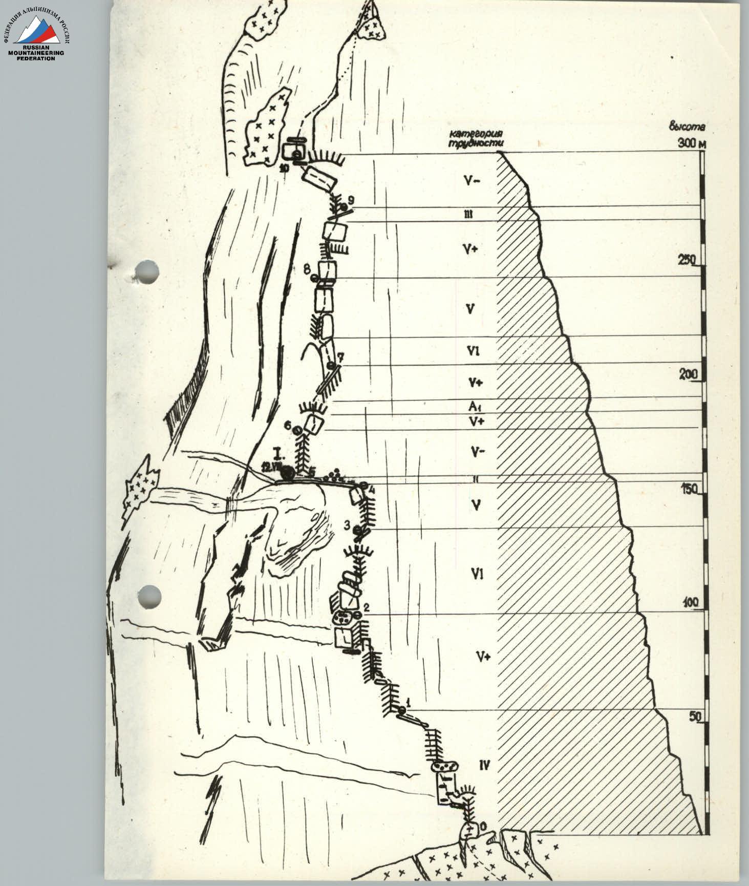
Route Sketch of the North-East Face of Vostochny Dombay-Ulgen
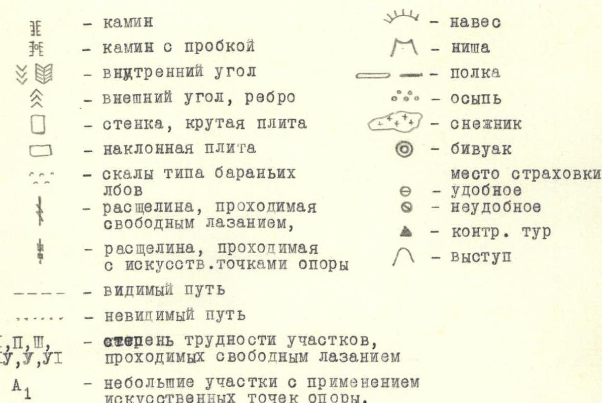
Main Notations
-
Chimney
-
Chimney with a plug
-
Internal corner
-
External corner, edge
-
Wall, steep slab
-
Inclined slab
-
Rocks resembling sheep's foreheads
-
Crevice passable by free climbing
-
Crevice passable with artificial footholds
-
Visible path
-
Invisible path
-
I, II, III, IV, V, VI - degree of difficulty for sections traversed by free climbing
-
A1 - small sections with artificial footholds
-
Overhang
-
Niche
-
Ledge
-
Scree
-
Snowfield
-
Bivouac
-
Belay point
-
Comfortable
-
Uncomfortable
-
Control cairn
-
Projection
Table of Main Characteristics of the Ascent Route
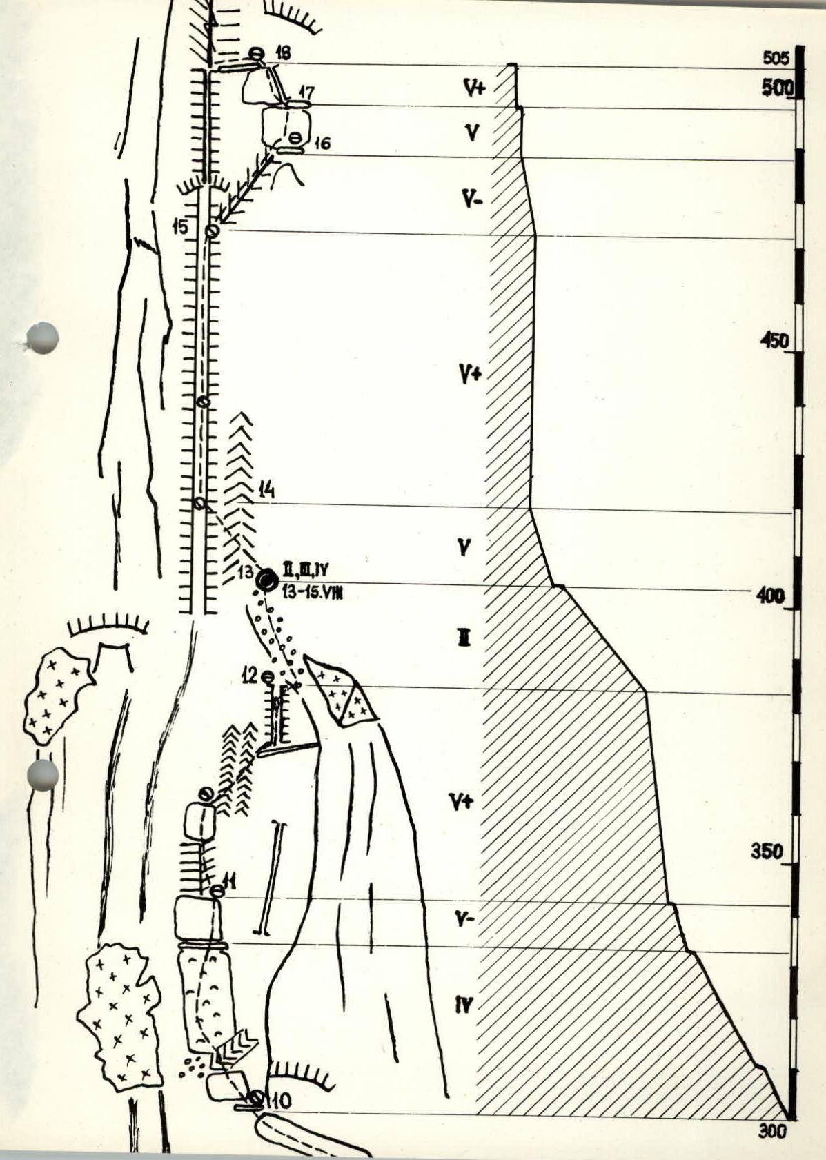
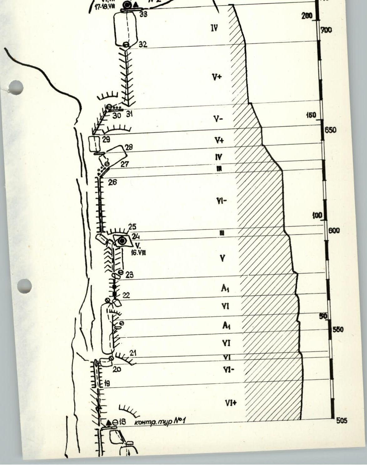
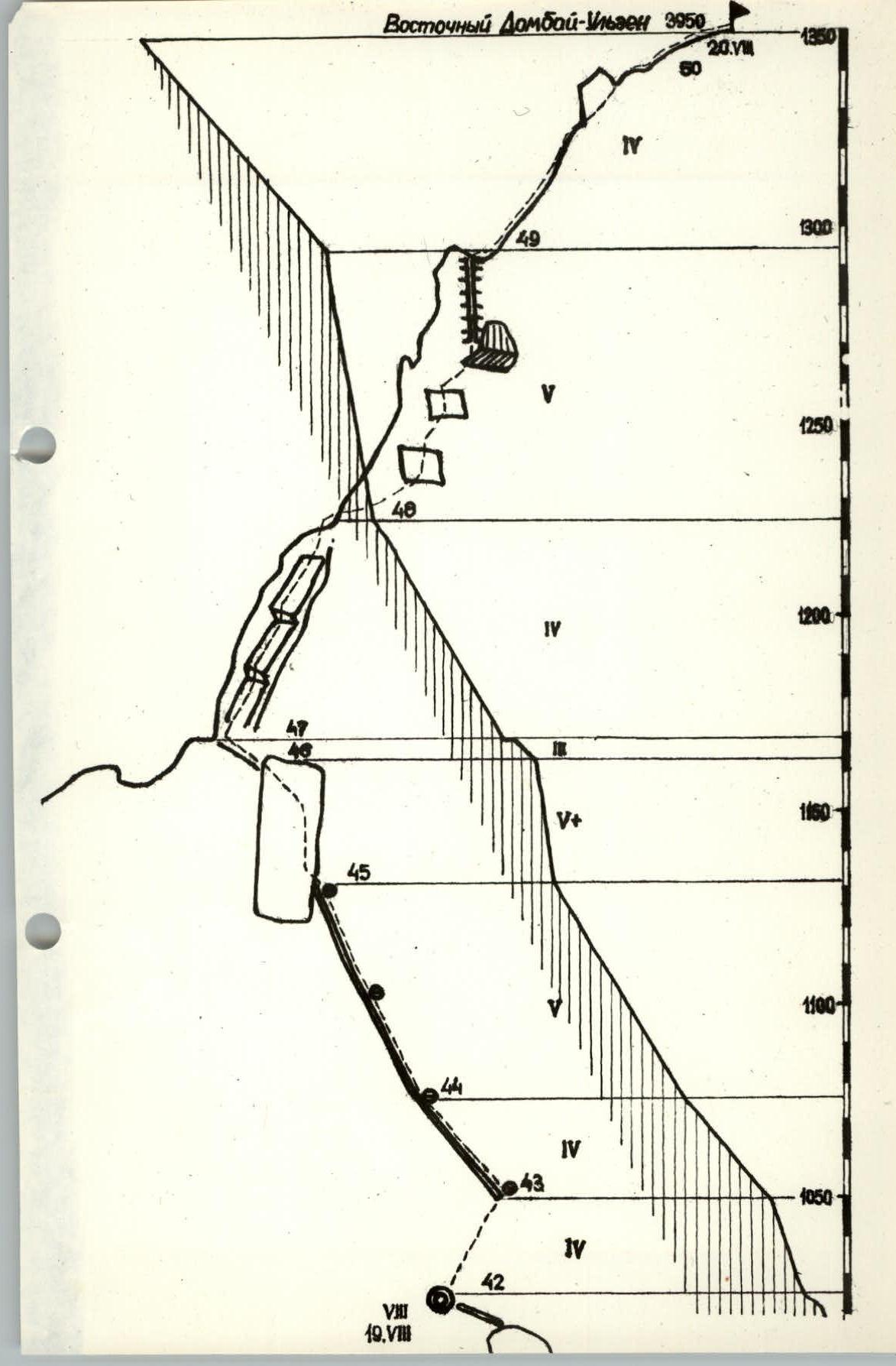
Ascent route - Vostochny Dombay-Ulgen via the north-east face. Route elevation gain (from glacier area to summit) - 1350 m. Including most challenging sections - 1040 m. Average route steepness - 72°
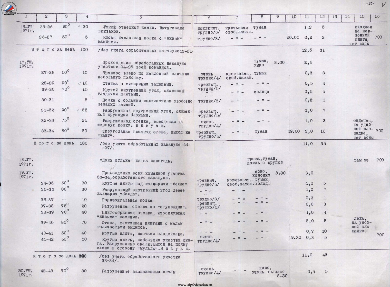
| Date | Sections Covered | Average Steepness of Section | Length of Section | Terrain Characteristics | Technical Difficulty | Method of Overcoming and Belaying | Weather Conditions | Departure Time | Bivouac Stop | Climbing Hours | Pitons Used | Ice Axes Used | Bolt Pitons Used | Bivouac Conditions | Daily Ration |
|---|---|---|---|---|---|---|---|---|---|---|---|---|---|---|---|
| August 11, 1971 | Processing | ||||||||||||||
| R0–R1 | 70° | 70 | Rocky wall with ledges. Many loose stones. Exit to a 10-meter ledge. | Very hard (4) | Piton belay, free climbing | Good, clear | 9:30 | 1.0 | 7 | ||||||
| R1–R2 | 85° | 40 | Wall with internal corners. Two overhanging sections of 4 m. Exit to an inclined platform with scree. | Extremely hard (5) | Piton belay, free climbing | Good, clear | 1.0 | 8 | |||||||
| R2–R3 | 90° | 40 | Wet rocks with overhang. | Exceptionally hard (6) | Piton belay, free climbing | Good, clear | 2.5 | 8 | |||||||
| R3–R4 | 85° | 20 | Wet internal corner. | Fairly hard (2) | Piton belay, free climbing | Good, clear | 1.0 | 5 | In base camp | 800 | |||||
| R4–R5 | 60 | Wide scree ledge. | 0.5 | 3 | |||||||||||
| Total for Day | 230 | After processing, the group descended to the base camp. | 6.0 | 31 | |||||||||||
| August 12, 1971 | |||||||||||||||
| R0–R5 | 230 | Traversing section R0–R5 by the entire team. Pulling backpacks (60 kg) on R2–R4. Bivouac on a wide ledge. | Clear | 7:00 | 6.5 | ||||||||||
| R5–R6 | 80° | 20 | Implicit internal corner on a counterfort. | Extremely hard (5) | Piton belay, free climbing | Fog | 1.0 | 8 | On a comfortable ledge | 800 | |||||
| R6–R7 | 80° | 40 | Steep 10-meter slab and over a small ledge (ladders) to a notch. | Exceptionally hard (6) | Piton belay, ladders, free climbing | Fog | 1.5 | 8 | |||||||
| R7–R8 | 80° | 50 | Slabby wall, upper part destroyed. | Exceptionally hard (6) | Piton belay, free climbing | Fog | 19:00 | 3.0 | 14 | ||||||
| Total for Day | 110 | (excluding R0–R5 processed the previous day) | 12.0 | 27 | |||||||||||
| August 13, 1971 | |||||||||||||||
| R5–R8 | 110 | Traversing section R5–R8, processed the previous day. Pulling backpacks throughout. | Clear | 7:30 | 6.5 | ||||||||||
| R8–R9 | 87° | 40 | Smooth wall with an overhang in the middle (traversed via an inclined crevice). Pulling backpacks. | Exceptionally hard (5) | Piton belay, free climbing | Fog | 1.3 | 12 | |||||||
| R9–R10 | 70° | 40 | Internal corner (5 m) and leftward along slabs to a ledge at the level of a snowfield. Pulling backpacks. | Extremely hard (5) | Piton belay, pendulum climbing | Fog | 1.8 | 7 | |||||||
| R10–R11 | 60° | 80 | Rocks resembling sheep's foreheads (in a depression right of the snowfield). | Very hard (4) | Piton belay, free climbing | Fog | 1.0 | 8 | |||||||
| R11–R12 | 85° | 60 | Destroyed rocky wall. Exit rightward upward from the depression onto a counterfort. | Extremely hard (5) | Piton belay, free climbing | Fog | 1.5 | 13 | |||||||
| R12–R13 | 50° | 40 | Simple destroyed ridge. | Fairly hard (2) | Piton belay, free climbing | Fog | 19:00 | 0.2 | 1 | Lying on a comfortable ledge | 700 | ||||
| Total for Day | 260 | (excluding R5–R7 processed the previous day) | 11.5 | 41 | |||||||||||
| August 14, 1971 | Bad weather. Sheltered at the bivouac. | Fog, rain | Same as before | 700 | |||||||||||
| August 15, 1971 | Processing the middle part of the wall R13–R21. | ||||||||||||||
| R13–R14 | 70° | 20 | From the bivouac site leftward upward along a ridge. Exit into a wide chimney. | Extremely hard (5) | Piton belay, free climbing | Fog | 10:00 | 0.5 | 4 | ||||||
| R14–R15 | 90° | 60 | Upward through a wide wet chimney under an overhanging section. | Exceptionally hard (6) | Piton belay, free climbing | Fog | 1.0 | 9 | |||||||
| R15–R16 | 80° | 20 | Internal corner composed of large blocks. | Exceptionally hard (6) | Piton belay, free climbing | Fog | 0.3 | 2 | |||||||
| R16–R17 | 90° | 10 | Vertical wall with good, solid holds. | Exceptionally hard (6) | Piton belay, free climbing | Fog | 0.3 | 2 | |||||||
| R17–R18 | 90° | 10 | Smooth vertical wall with a crevice (notch) on the right. Exit onto a comfortable ledge. | Exceptionally hard (6) | Piton belay, free climbing | Fog | 0.4 | 2 | |||||||
| R18–R19 | 95° | 20 | Overhanging crevice inside a corner with smooth walls. | Exceptionally hard (6) | Artificial climbing (A1) | Fog | 2.0 | 5 | |||||||
| R19–R20 | 90° | 12 | Wet chimney. Many "live" projections. | Exceptionally hard (6) | Piton belay, free climbing | Fog | 1.0 | 4 | |||||||
| R20–R21 | 70° | 8 | Traverse rightward from the chimney along a wet slab. | Exceptionally hard (6) | Piton belay, free climbing | Fog | 16:00 | 0.5 | 2 | Same as before | 700 | ||||
| Total for Day | 160 | (Some equipment and supplies cached on ledges R18 and R21 during processing) | 6.0 | 30 | |||||||||||
| August 16, 1971 | Traversing processed sections R13–R21 by the entire team. Pulling backpacks. | Clear, cold | 7:30 | 6.0 | |||||||||||
| R21–R22 | 93° | 30 | Smooth wall of a steep internal corner. Ladders, pulling backpacks. Exit onto an inclined slab. | Exceptionally hard (6) (10 m - A1) | Piton belay, ladders | Fog | 2.5 | 14 | |||||||
| R22–R23 | 95° | 10 | Overhanging internal corner with a vertical wide crack. Pulling backpacks. | Artificial climbing (A1) | Piton belay, ladders, free climbing | Fog | 1.5 | 6 | |||||||
| R23–R24 | 85° | 20 | Internal corner leading onto a wide inclined slab. Bivouac. | Exceptionally hard (6) | Piton belay, free climbing | Fog | 1.0 | 4 | Hanging on an inclined slab | 700 | |||||
| R24–R25 | 45° | 5 | Oblique inclined ledge. | Hard (3) | Piton belay, free climbing | Fog | 20:00 | 0.2 | 2 | ||||||
| R25–R26 | 90° | 30 | Narrow steep chimney. Pulling backpacks. | Exceptionally hard (6) | Piton belay, free climbing | Fog | 1.2 | 5 | |||||||
| R26–R27 | 50° | 5 | Oblique inclined ledge with "live" stones. | Hard (3) | Piton belay, free climbing | Fog | 0.2 | 2 | |||||||
| Total for Day | 100 | (excluding R13–R21 processed the previous day) | 12.5 | 31 | |||||||||||
| August 17, 1971 | Traversing processed sections R24–R27 by the entire team. | Fog, damp | 8:00 | 2.5 | |||||||||||
| R27–R28 | 50° | 10 | Traverse leftward along an inclined slab onto a small ledge. | Very hard (4) | Piton belay, free climbing | Fog | 0.3 | 3 | |||||||
| R28–R29 | 90° | 10 | Wall with minimal holds. | Extremely hard (5) | Piton belay, free climbing | Fog | 0.5 | 4 | |||||||
| R29–R30 | 70° | 15 | Steep internal corner composed of smooth slabs. | Extremely hard (5) | Piton belay, free climbing | Sun | 0.5 | 5 | |||||||
| R30–R31 | 5 | Ledge with many loose stones. | Hard (3) | Piton belay, free climbing | Sun | 0.2 | 1 | ||||||||
| R31–R32 | 90° | 35 | Destroyed internal corner composed of large blocks. | Extremely hard (5) | Piton belay, free climbing | Sun | 3.0 | 7 | |||||||
| R32–R33 | 75° | 25 | Destroyed wall leading onto a wide ledge. Bivouac. | Very hard (4) | Piton belay, free climbing | Sun | 19:00 | 1.0 | 3 | Sitting on a comfortable ledge | 700 | ||||
| R33–R34 | 80° | 80 | Triangular smooth wall, exit onto a "cantilever". | Extremely hard (5) | Piton belay, free climbing | Fog | 3.0 | 12 | |||||||
| Total for Day | 180 | (excluding R24–R27 processed the previous day) | 11.0 | 35 | |||||||||||
| August 18, 1971 | "Rest day" due to bad weather. | Thunderstorm, fog, rain with hail | Same as before | 700 | |||||||||||
| August 19, 1971 | Traversing section R33–R34 by the entire team, processed the previous day. | Clear, cold | 8:30 | 3.0 | |||||||||||
| R34–R35 | 60° | 30 | Steep slabs under a "bald" gendarme. | Extremely hard (5) | Piton belay, free climbing, cold | Fog | 1.0 | 5 | |||||||
| R35–R36 | 80° | 30 | Destroyed internal corner left of the "bald" gendarme. | Extremely hard (5) | Piton belay, free climbing, cold | Fog | 1.0 | 7 | |||||||
| R36–R37 | 10 | Horizontal ledge. | Hard (3) | Piton belay, free climbing, cold | Fog | 0.2 | 1 | ||||||||
| R37–R38 | 75° | 20 | Destroyed wall with "steps". | Extremely hard (5) | Piton belay, free climbing, cold | Fog | 0.8 | 3 | |||||||
| R38–R39 | 70° | 40 | Slabby wall abounding in "live" stones. | Extremely hard (5) | Piton belay, free climbing, cold | Fog | 1.0 | 4 | |||||||
| R39–R40 | 80° | 70 | Wall composed of slabs with few holds. | Exceptionally hard (6) | Piton belay, free climbing, cold | Fog | 3.0 | 8 | Lying on a comfortable ledge | 700 | |||||
| R40–R41 | 60° | 40 | Steep slabs, partially icy. | Very hard (4) | Piton belay, free climbing, cold | Fog | 0.7 | 10 | |||||||
| R41–R42 | 50° | 60 | Steep slabs, small snow sections. Destroyed rocks. Exit onto a ledge leftward towards a "mulda". Bivouac. | Very hard (4) | Piton belay, free climbing, cold | Fog | 19:30 | 0.3 | 5 | ||||||
| Total for Day | 300 | (excluding the processed section R33–R34) | 11.0 | 43 | |||||||||||
| August 20, 1971 | |||||||||||||||
| R42–R43 | 70° | 30 | Destroyed snowy rocks. | Very hard (4) | Piton belay, free climbing | Clear, very cold | 8:30 | 0.5 | 5 | ||||||
| R43–R44 | 50° | 40 | Steep ledge (slabs, partially rime ice). | Very hard (4) | Piton belay, free climbing | Clear, very cold | 1.0 | 4 | |||||||
| R44–R45 | 60° | 80 | Steep intermittent ledge. Heavily destroyed rocks. Snow, rime ice. | Extremely hard (5) | Piton belay, free climbing | Fog | 1.8 | 10 | |||||||
| R45–R46 | 80° | 60 | Steep wall with "live" projections. Pulling backpacks. | Extremely hard (5) | Piton belay, free climbing | Fog | 3.0 | 10 | |||||||
| R46–R47 | 40° | 15 | Ledge, small slab at the exit onto the saddle. | Hard (3) | Piton belay, free climbing | Fog | 0.2 | 1 | |||||||
| R47–R48 | 60° | 80 | Tile-like rocks on the eastern wall of the summit tower (5B category route). | Very hard (4) | Piton belay, free climbing | Fog | 0.7 | 4 | |||||||
| R48–R49 | 80° | 120 | Rocks on the northern side of the summit tower. | Extremely hard (5) | Piton belay, free climbing | Fog | 1.2 | 8 | On a comfortable ledge on the descent | 700 | |||||
| R49–R50 | 50° | 100 | Pre-summit ridge. Exit onto the summit of Vostochny Dombay-Ulgen (3950 m). | Very hard (4) | Piton belay, free climbing | Fog | 17:30 | 0.5 | 4 | ||||||
| Total for Day | 525 | Descent from the summit onto the saddle and further down the south face (5B category route). | 9.0 | 46 |
Total: 1865 m of the route completed over 8 days (plus two days of bad weather). Climbing hours: 69.0; 284 pitons used.

Footnotes
-
This description is an addition to the table of main characteristics of the ascent route. ↩


