2.2.6362
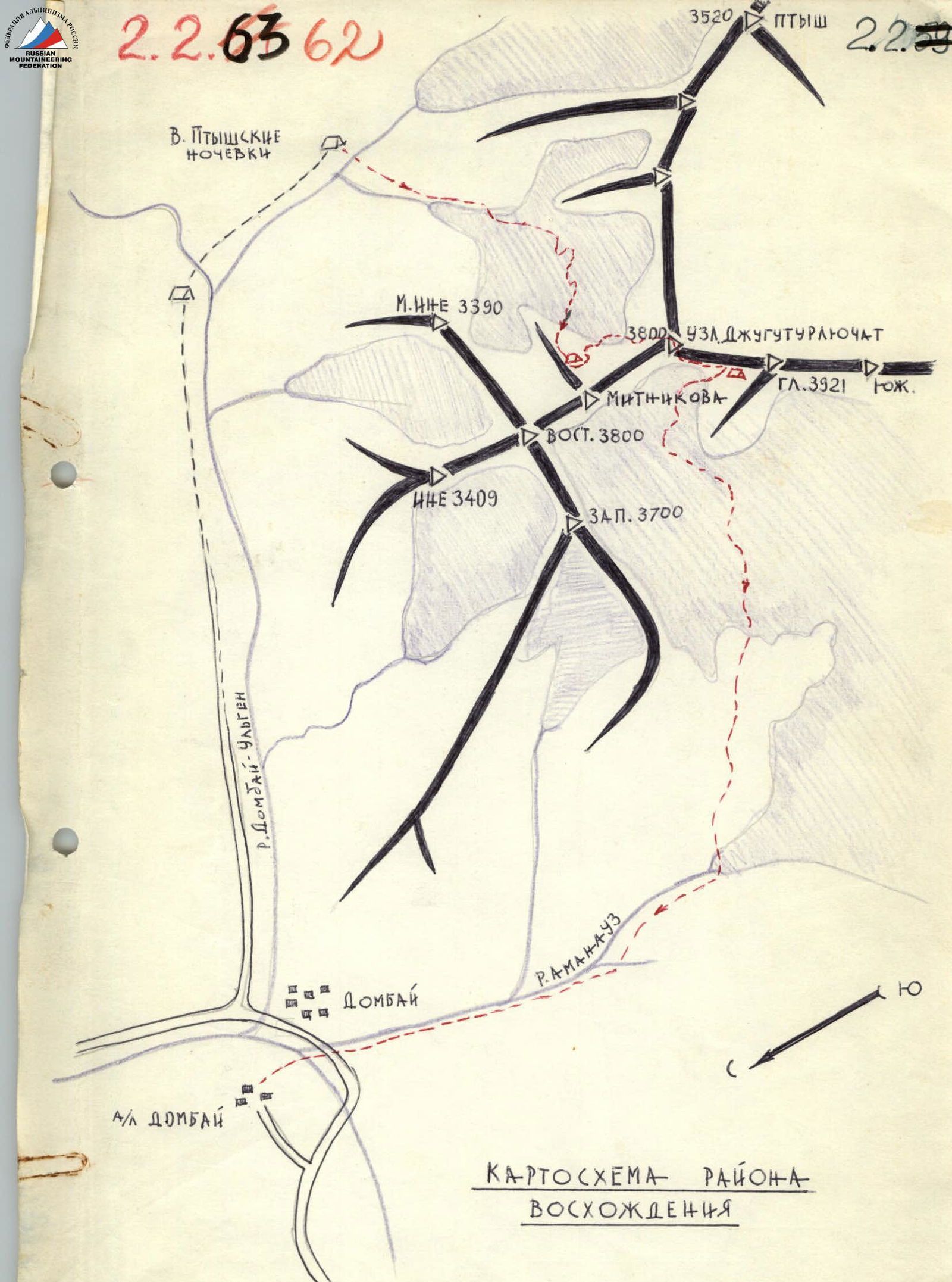 The summit of Uzlovaya Dzhuguturlyuchat is located in the Main Caucasian Range (MCR). This section of the MCR starts from the Amanauz massif, after which the ridge lowers to the rarely visited "Nauka" pass and continues further - to the complex terrain of the multi-summit massif, connecting with the South summit of Dzhuguturlyuchat. From it, the ridge turns northeast to the Main (3921 m) and Uzlovaya (3800 m) summits of Dzhuguturlyuchat, from which a short spur branches off to peak Mitnikov (3700 m) and further to the East summit of Dzhuguturlyuchat (3880 m). From the latter, the spur branches out:
- to the north - to peak Ine (3409 m)
- to the west - to the West summit of Dzhuguturlyuchat (3700 m).
The massifs of Dzhuguturlyuchat and Amanauz form a huge cirque, in which three glaciers are located.
From the summit of Uzlovaya Dzhuguturlyuchat, the ridge has an eastern direction and connects to the rocky summit of Ptysh (3520 m). This section of the ridge is known as Akbeksky.
The route to the summit of Uzlovaya Dzhuguturlyuchat runs along the eastern edge, which stretches parallel to the 3B category route to peak Mitnikov. The route is rocky in nature, except for the approach to the edge, which passes through the East Dzhuguturlyuchat glacier.
From the "Dombay" tourist center to the Ptysh camps, this path is well described in Kropf's book (part 3). The ascent from the Ptysh camps to the East Dzhuguturlyuchat glacier plateau is possible through three broad couloirs:
- the 1st descends under the slopes of the Akbek peaks;
- the 2nd - directly opposite the Ptysh camps;
- the 3rd adjoins peak Maly Ine.
The most convenient and closest path is through the middle couloir, which is located opposite the Ptysh camps.
Move along the couloir on its left side (there is a serac on the right!) and then left along the ledge and up the "barranii lby" - exit to the glacier. Traverse the couloir early in the morning and monitor the top during the passage: rockfall and icefall are possible. Before exiting the glacier, rope up. Along the glacier, left-upwards, avoiding crevasses, exit to the gentle part of the glacier and along it to the right - exit to the plateau. Along the plateau, up-right in the direction of the eastern counterfort of peak Mitnikov on the left side, along the snowy slope, to the saddle. 100-120 m up the counterfort from the saddle - a convenient place for camping. "Teplye nochyovki" (Warm camps). From here to Kropf's camps - one hour's walk. When ascending to Uzlovaya Dzhuguturlyuchat along the eastern edge, it is more convenient to stop at the "Teplye nochyovki". The path from the Ptysh camps - 3.5-4 hours.
From the bivouac on the counterfort of peak Mitnikov, down along the ridge to the snowy slope and from here, traversing under the rocks 150 m - exit to the widened couloir between Uzlovaya Dzhuguturlyuchat and peak Mitnikov. Approach to the bergschrund. Crossing the bergschrund - along the rocks (on the right) or along the snow (on the left). After the bergschrund - along the steep snowy slope (45-50°, 60 m) left upwards to the rocks of the eastern edge of Uzlovaya Dzhuguturlyuchat. The first ascent of the edge is bypassed on the right:
- first along steep snow, 60 m;
- then along rocks, 30 m - with an exit to a wide talus ledge (fig. 1).
Approach along the ledge to the inner corner. Along the right wall of the inner corner upwards 20-22 m under the overhanging rocks and traverse 15-16 m to the right along smooth slabs (2), fig. 1 to the right edge (pitons!). Steepness of the section is initially 60°, and in the upper part - 80°. When exiting to the edge in the recess of the rock - a control cairn (3), fig. 1. From here upwards along the wall 70°, 12 m (4), fig. 1 - exit to the inner corner (5), fig. 1 - with steepness at the bottom 85°, in the upper part - 90°. The length of the inner corner is 18-20 m, the upper 8-10 m are practically without holds. Pass with the help of ladders and wooden wedges, which can be hammered into the crack (6), fig. 1. Pass the section with rope-pulling.
The inner corner leads to the ridge. Along the ridge 15-18 m to an eight-meter narrow smooth chimney, along which:
- exit upwards to the right side to a ledge
- then along a 20-meter wall directly upwards,
- further along slabs (60-65°, 60 m) exit to the left side of the edge, to a ledge (7), fig. 2 under a steep ascent (pitons!).
The talus ledge (7), fig. 2 at first glance is very convenient for camping, but is actually dangerous due to falling rocks. From the ledge:
- ascent 5 m to another ledge,
- from it traverse left 10-12 m along smooth slabs to a ledge (8), fig. 2 (pitons!).
From the ledge along a 10-meter sheer tile-like wall (9), fig. 2 (there are no cracks for pitons) directly upwards - difficult climbing with a limited number of holds - and then right-upwards along the outer corner, bypassing the overhanging section (10), fig. 2 - under overhanging reddish rocks to a ledge (11), fig. 2 and fig. 3. Length 40 m, steepness - 80°. Pass with rope-pulling. Pitons!
From the ledge (11), fig. 3 - upwards 2 m and then traverse left 12 m under overhanging slabs (14), fig. 3, bypass the overhanging rock (12), fig. 3 on the left along the crack (13), fig. 3 - to the right under the overhang. From here left along smooth slabs (15), fig. 3 - 15-16 m - exit to a small ledge (16), fig. 3. Very difficult climbing using ladders and pulling ropes. Pitons, there are places for wooden wedges. On the small ledge, the whole group can gather.
From the small ledge left-upwards along smoothed rocks and then right-upwards along a vaguely defined inner corner 40 m - exit to the ridge (pitons!). Steepness 60-65°. On the ridge, we find ourselves at the base of a large triangle formed by two edges. Here under the wall is a convenient place for camping.
From here, move left-upwards along steep 70-degree ledges in the direction of the left edge. To the edge 50 m (pitons!). Exit to the edge and along it, overcoming:
- 5-6-meter sheer walls,
- alternating with ledges,
move to the right in the direction of the confluence point of the left and right edges.
From the point of exit to the edge to the point of confluence of the edges - 60-65 m (pitons!). Here is an oblique ledge (17), fig. 4.
From here along a sheer 15-17 m wall - exit to a cirque (18), fig. 4, along which to the right on an 8-meter sheer wall - exit beyond the bend of the edge (19), fig. 4.
Further along steep rocks on the right part of the edge 150 m to the exit under the pre-summit ascent. Here the rocks are steep - 70°, but there are many good holds and protrusions.
Exit to the ridge, bypass a small gendarme on the ridge on the left, then traverse 10 m to the right along the wall and along the couloir - exit to the summit. From the "Teplye nochyovki" to the summit - 15-18 hours. The entire route from the camp to the summit took the first ascenders 18 rope lengths of 40 m.
On the route, 75-80 pitons were hammered. The set of pitons is the most diverse, including wooden wedges. Groups starting the route must have:
- 2 ladders
- at least one pair of galoshes.
When pulling ropes, a block was used for pulling ropes. Descent from the summit along the 3A category route described in the book "Western Caucasus" by F.A. Kropf.

2
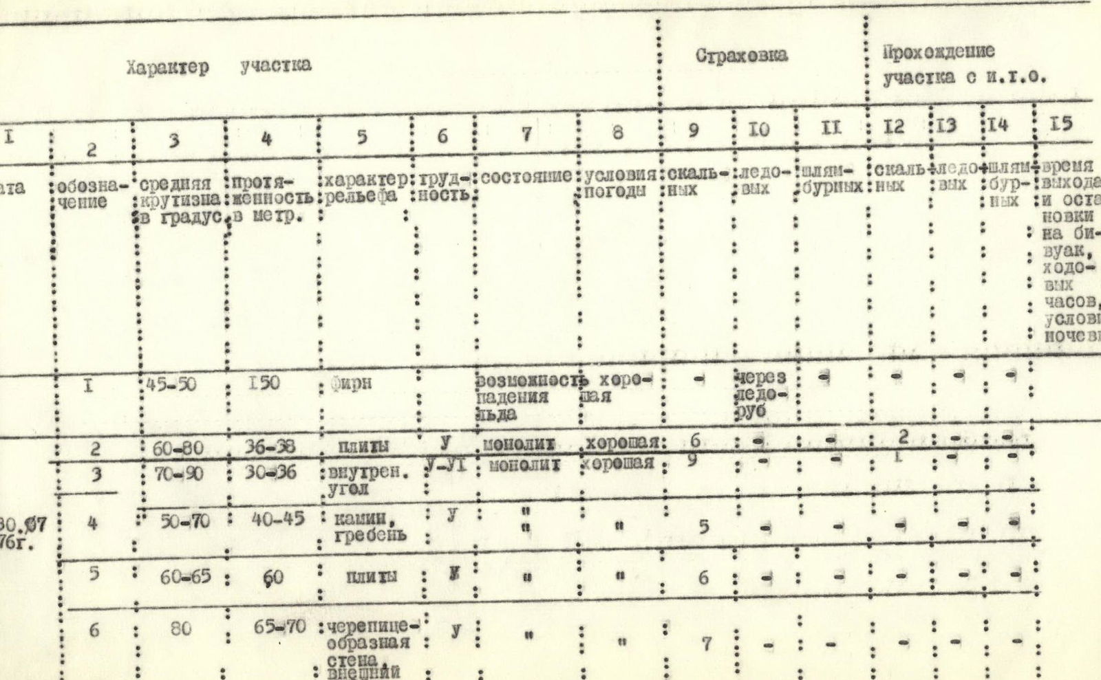
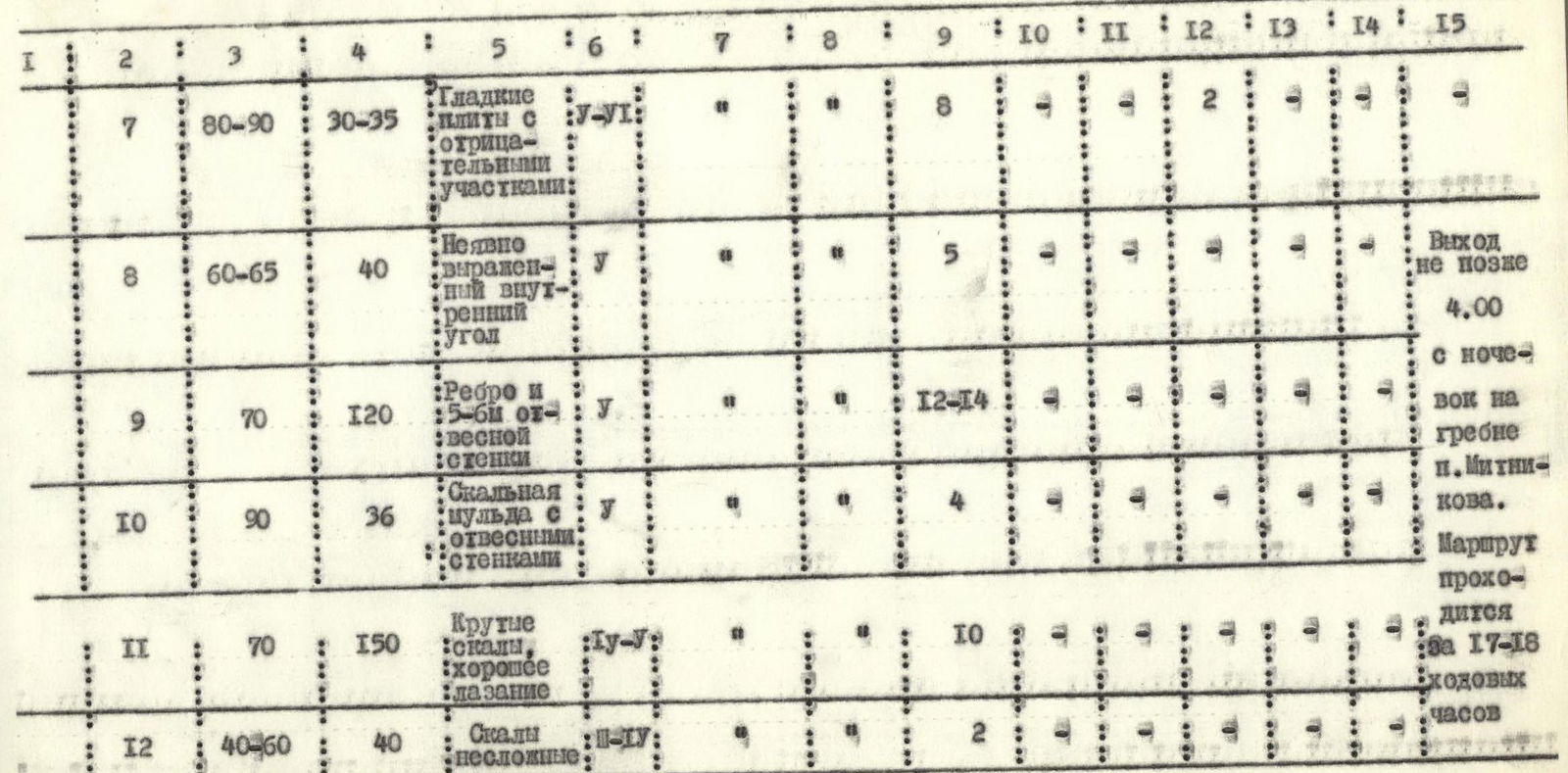
| № | Designation | Avg. steepness (°) | Length (m) | Terrain character | Category of difficulty | Condition | Weather conditions | Belay: Rock | Belay: Ice | Belay: Bolted | I.T.O.: Rock | I.T.O.: Ice | I.T.O.: Bolted | Time, conditions |
|---|---|---|---|---|---|---|---|---|---|---|---|---|---|---|
| 1 | 45–50 | 150 | firn | Possibility of ice fall | good | via ice axe | ||||||||
| 2 | 60–80 | 36–38 | slabs | 5 | monolith | good | 6 | 2 | ||||||
| 3 | 70–90 | 30–36 | inner corner | 5 | monolith | good | 9 | 1 | ||||||
| 4 | 50–70 | 40–45 | chimney, ridge | 5 | 5 | |||||||||
| 5 | 60–65 | 60 | slabs | 1 | 6 | |||||||||
| 6 | 80 | 65–70 | tile-like wall, outer corner | 5 | 7 | |||||||||
| 7 | 80–90 | 30–35 | smooth slabs with negative sections | 5–6 | 8 | 2 | ||||||||
| 8 | 60–65 | 40 | vaguely defined inner corner | 5 | 5 | |||||||||
| 9 | 70 | 120 | edge and with sheer wall | 5 | 12–14 | |||||||||
| 10 | 90 | 36 | rock cirque with sheer walls | 5 | 4 | |||||||||
| 11 | 70 | 150 | steep rocks, good climbing | 4–5 | 10 | |||||||||
| 12 | 40–60 | 40 | rocks not difficult | 3–4 | 2 |


