
Ascent Record
I. Technical Climbing Category. 2. Dombay Region, North-West Caucasus. 3. German Comsomol Peak, ~3600 m, from Belalakaysky Glacier. 4. Category of difficulty — 2A. 5. The route is combined, with a height difference from the glacier of ~1000 m. 6. Belay — without pitons. 7. Number of climbing hours from the moraine bivouac: ascent 5–6 hours, descent — 3 hours. 8. Training group: Starikov G.A. — 1st sports category, instructor Kruchikov Yu. — III, Koblyakov V. — III, Rakhmatov R. — III, Galimyanov N. — III 9. Training section of the "Dombay" alpine camp, Honored Coach of the Ukrainian SSR Ovcharov V.V. 10. The description was compiled during the traverse of German and Austrian Comsomol peaks, category 3A, completed on August 2, 1976 (without credit for the first ascent).
Ascent Description
The path from the "Alibek" alpine camp to the bivouac on the middle moraine of Belalakaysky Glacier takes 2.5 hours (see description for Alibeksky Peak, category 1). From here, the start and almost the entire route of the upcoming ascent are visible (photo 2).
Forming rope teams, approach the start of the "ridge" via the glacier and ascend up and to the left via the talus slope to the left of the stream, towards the red cliffs — 1 hour. Then, ascend a steep snowy slope (glacier) with a turn to the right, leading to the "shoulder" of the "ridge". Here lies a cairn with a note — another 1 hour. Along the rocky ridge, approach the snowy "dome"; a 10-meter damaged rocky belt is encountered, which is overcome to the left via ledges with occasional belays. Ascend the snowy slope (possibly icy in the second half of summer) under the bergschrund of the "dome" and traverse right along it to a convenient passage, exiting onto the saddle of the main ridge between the "dome" and Alibeksky Peak (photo 3). Climb to the "dome" along the ridge to the left — another 1 hour. From there, traverse the saddle (beware of a sharp snowy ridge) and continue ascending towards Dzerzhinsky Peak; a wide crevasse is encountered, which is bypassed on the left. Under the peak lies a bergschrund, which needs to be approached and traversed to the right to a convenient passage upwards; 30 meters up a steep snowy slope, exit onto the ridge and along it to the left to the summit of Dzerzhinsky Peak. From the moraine bivouac — 4–5 hours.
From the summit:
- Descend along the ridge for 50 m,
- Then descend onto the left side of the ridge via ledges (40 m) and traverse right along them to rejoin the main ridge.
- Ascend German Comsomol Peak along the rocky, straightforward ridge with some snowy sections, and its right side, bypassing a wide gap — another 1 hour.
The descent follows the ascent route back to the moraine, taking 3 hours.
Description compiled by — Starikov G.A.

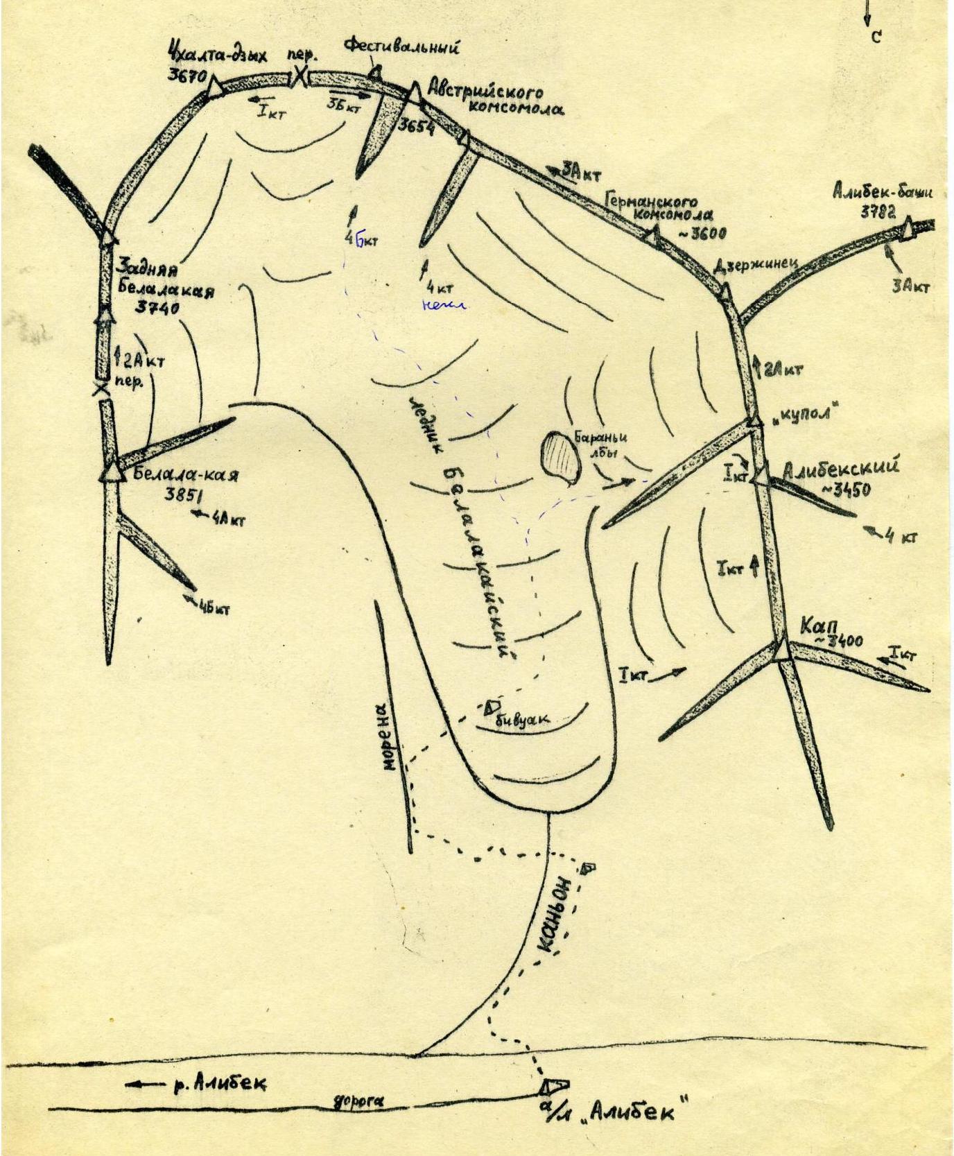
Map-Scheme of the Region
Comments
Sign in to leave a comment