Route Description
From the "conical moraine" of the Amanauz glacier, you need to approach the first step of the glacier along its central part. The first step is bypassed under the slopes of the Juguтурлючат massif. After reaching the plateau of the first step, to approach the wall, you need to pass through the icefall. The landmark for the direction of movement is the rocky ridge that limits the icefall along the eastern slope of Uzlovaya Amanauz. The icefall should be traversed along its central part (R1) to the level of the beginning of the rocky ridge, then approach the rocks and along the boundary of ice and rocks, exit to the ice falls under the wall of Uzlovaya Amanauz. The approach to the beginning of the route is first along the rocky ridge, then in the central part of the icefall, transition to the wall. A bivouac under the wall can be arranged on one of the terraces of the icefall.
The landmark for the beginning of the route is the rusty rocks in the lower part of the wall, cut by a deep groove. There are many stones on the ice in this part, brought down by winter snow from the terrace behind the wall's bend. In the summer, the approach to the wall is practically safe.
To exit to the wall, you need to overcome the bergschrund. At the end of July, the bergschrund is greatly torn (R2). Through the "plug," approach the rocks and through the ice cornice back to the rocks.
Along the rocks of medium difficulty, you need to ascend 100 m upwards under the overhanging wall (R2). From this place, 150 m to the right upwards in the direction of a large spall. The first 40 m is a traverse along the slabs with small ledges under the inner corner (at the beginning of the corner, the first control point is in a bank suspended on a hook), then along the inner corner (very difficult climbing) upwards 40 m (R4). In the direction of the spall, you need to pass 70 m until you exit to the spall from above. This is a section of steep rocks, which are overcome by complex climbing (R5).
On the spall, there is a place for a sitting overnight stay for 2-4 people and the second control point.
From the spall, straight up under the cornice, bypassing it on the left (100 m) - exit to the ridge that borders the rocky depression on the left (R6). Here, very complex climbing with the use of artificial support points.
Along the ridge, 50 m to the left upwards along the rocks of medium difficulty under the continuation of the wall. From a small isthmus between the ridge and the wall, there is a rockfall hazard. Up the wall, 30 m of very complex climbing and then 20 m - traverse to the right along the rocks of medium difficulty to a steep (40°) inner corner.
Along it - exit to the terrace (R7-R9). Here you can organize a place for an overnight stay. There is water.
Along the terrace to the left upwards along the rocks of medium difficulty (200 m) under the base of the steep bastion leading to the ridge of the summit (R10). At the base - the third control point, from which straight up 100 m of very complex climbing with the use of artificial support points, exit to the ridge leading to the summit.
Along the ridge to the summit - 15-20 minutes. The average steepness of the wall part of the route is 85°. The rocks on the complex sections are strong with a small microrelief, the cracks are narrow. For the ascent, a set of usual VCSSP Sov's hooks with a predominance of combined ones is recommended. It is desirable to have petal-shaped ones. Total quantity - 30 pieces.
To overcome the icefall and descend, the following are necessary:
- crampons for all participants.
The sun is on the wall at the end of July from 6:30 to 13:00.

Amanauz (Uzlovaya, Summit) 3700 m
| Section | Length | Steepness | Cat. diff. |
|---|---|---|---|
| R11 | — | — | — |
| — | 100 m | 90° | 6 |
| R10 | — | — | — |
| — | 200 m | 70° (traverse) | 4Б |
| R9 | — | — | — |
| — | 70 m | 75° | 4Б |
| R8 | — | — | — |
| — | 30 m | 90° | 5Б |
| R7 | — | — | — |
| — | 50 m | 75° | 5А |
| R6 | — | — | — |
| — | 50 m | 85° | 5Б |
| — | 50 m | 90° | 6 |
| R5 | — | — | — |
| — | 70 m | 85° | 5Б |
| R4 | — | — | — |
| — | 40 m | 90° | 5Б |
| — | 40 m | 80° | 4Б |
| R3 | — | — | — |
| R2 | — | — | — |
| — | 100 m | 70° | 4Б |
| R1 | — | — | — |
Note: Average steepness 85° Height difference — 650 m (from the icefall to the highest summit) Route length — 750 m (of which the length of sections 6 and 5Б cat. diff. — 350 m)
Reference: 6 WCON – 6.50 (for segments 90° correct) Manufacturing: Mipolegm – 150 m (of the same segment as Mipolegm) Approved: 6 WCON – 6.50 m. 350 m
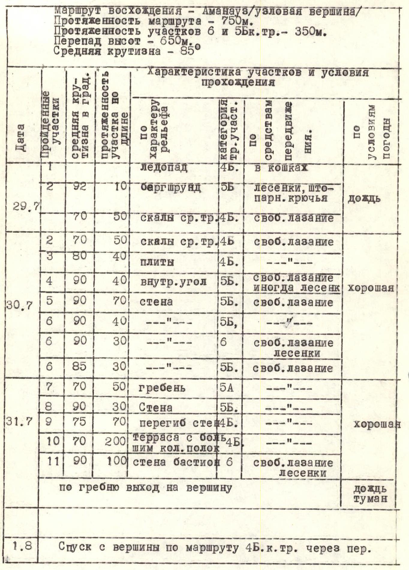
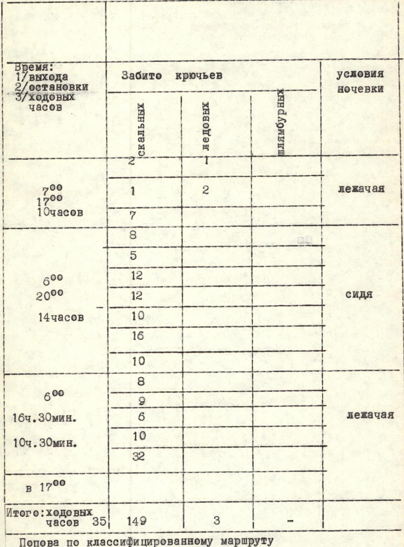
Table of Main Characteristics of Ascent Routes
Ascent route — Amanauz (Uzlovaya, Summit) Route length — 750 m. Length of sections 6 and 5Б cat. diff. — 350 m. Height difference — 650 m. Average steepness — 85°.
| Date | Passed sections | Average steepness (in °) | Section length (in m) | Terrain character | Section difficulty category | Means of movement | Weather |
|---|---|---|---|---|---|---|---|
| — | icefall | — | — | — | 4Б | with crampons | — |
| 29 July | 1 | 92 | 10 | bergschrund | 5Б | ladders, piton hooks | rain |
| — | 1 | — | 50 | rocks of medium difficulty | 4Б | free climbing | — |
| — | 2 | 70 | 50 | rocks of medium difficulty | 4Б | free climbing | — |
| — | 3 | 80 | 40 | slabs | 4Б | — | — |
| — | 4 | 90 | 40 | inner corner | 5Б | free climbing, sometimes ladders | good |
| 30 July | 5 | 90 | 70 | wall | 5Б | free climbing | — |
| — | 6 | 90 | 40 | — | 5Б | — | — |
| — | 6 | 90 | 30 | — | 6 | free climbing, ladders | — |
| — | 6 | 85 | 30 | — | 5Б | free climbing | — |
| — | 7 | 70 | 50 | ridge | 5А | — | — |
| — | 8 | 90 | 30 | wall | 5Б | — | — |
| 31 July | 9 | 75 | 70 | wall bend | 4Б | — | good |
| — | 10 | 70 | 200 | terrace with many ledges | 5Б | — | — |
| — | 11 | 90 | 100 | bastion wall | 6 | free climbing, ladders | — |
| — | along the ridge to the summit | — | — | — | — | — | — |
| 1 August | descent from the summit along the 4Б cat. diff. route through the pass | — | — | — | — | — | — |
Ascent Route Log
| Time: Departure, stops, travel hours | Driven hooks (rock) | Driven hooks (ice) | Driven hooks (piton) | Overnight conditions |
|---|---|---|---|---|
| 7:00–17:00 (10 h) | 1 | 2 | — | lying |
| — | 7 | — | — | — |
| — | 8 | — | — | — |
| — | 5 | — | — | — |
| 6:00–20:00 (14 h) | 12 | — | — | sitting |
| — | 12 | — | — | — |
| — | 10 | — | — | — |
| — | 16 | — | — | — |
| 6:00–16:30 (10 h 30 min) | 10 | — | — | lying |
| — | 8 | — | — | — |
| — | 9 | — | — | — |
| — | 6 | — | — | — |
| — | 10 | — | — | — |
| — | 32 | — | — | — |
| At 17:00 | — | — | — | — |
| Total: travel hours 35 | 149 | 3 | — | — |
| Popova along the classified route | — | — | — | — |
Evaluation of the Passed Route
The object of ascent Amanauz (Uzlovaya, Summit) along the eastern wall is located in the upper part of the Amanauz cirque. Most of the approach path coincides with the approach paths and routes to the summits of the Juguтурлючат and Amanauzsky massifs, popular in this area. The entire route can be seen from the first step of the Amanauz glacier, and its upper part is practically visible from anywhere in the Amanauz valley. Radio communication: in the lower part of the route - in direct line of sight with the "Dombay" tourist center, and in the upper part - stable communication with the "Alibek" tourist center. The route is combined. The wall part of the route, 750 m long, is practically safe, since most of the route is protected by the upper overhanging part of the wall, ending in a terrace. The path is logical with well-distinguished landmarks. The route is difficult to pass, and of great steepness (average steepness 85°). However, the microrelief and structure of the rocks allow it to be passed without the use of piton technique. Especially difficult to pass is the 100-meter bastion, ending in the pre-summit ridge. Some of its sections have a negative slope and are very difficult to overcome, especially since the bastion is the final part of the wall. Thus, throughout the entire route, full exertion of strength is required. There is no water on most of the route (up to the terrace). It is possible to organize a lying overnight stay only on the terrace.
Taking into account the experience of previous ascents of the group members, it is possible to confidently evaluate this route as a 5Б cat. diff. route.
Technical Climbing Experience of Group Members
- Uzhba South along the N.W. wall — 6 cat. diff.
- P. 5497 m (S.W. Pamir) — 6 cat. diff.
- Sanguti — 5Б+1 cat. diff.
- Mamisong (Bolychevsky's route) — 5Б+1 cat. diff.
- Arkh (along the North wall, Fan Mountains) — 5Б+1 cat. diff.
- Sugar Head–Moscow–Block (traverse, Fan Mountains) — 5Б+1 cat. diff.
- Uilpata — 5Б cat. diff.
- Mamisong (Barov's route) — 5Б cat. diff.
- Passionaria — 5Б cat. diff.
- Dombay-Ulgen–TsDSA along the South wall — 5Б cat. diff.
Protocol
of the analysis of the first ascent of the group of instructors from "Alibek" tourist center to the summit of Amanauz (Uzlovaya) along the Eastern wall.
Present: Releasing — Neborak V.S. Participants:
- Vselyubsky A.I. — leader
- Maly A.F.
- Bondarev V.M.
- Nagorny S.A.
Vselyubsky A.I.: "Interest in this object arose back in 1972, but the real opportunity to make this ascent presented itself only two years later. Preliminary, two reconnaissance exits were made, one of which was a throw to the upper step of the Amanauz glacier icefall. The reconnaissance showed that the possibility of overnight stay on the wall is associated with certain difficulties, so it was decided to make a preliminary processing of the route from the bivouac under the wall. The exit from the camp was scheduled for July 26, 1953. Due to bad weather, we had to spend the night at the site of the first throw. The next day, bad weather forced us to stop at a bivouac at 12 noon, and only in the evening, two hours of "relative weather" allowed us to start processing the wall, overcome the bergschrund and the first 50 m of the rock wall.
On July 30, the group entered the route. As expected, the first four ropes (ropes 50 m long) turned out to be very difficult to overcome. The character of the wall - steep sections with a small microrelief. Very complex climbing with the use of artificial support points in the most difficult places.
Features of the passage:
- The first in the group went without a backpack, for this purpose the group had three backpacks assembled.
- The change of leader during the day was not made, as it would have taken a lot of time in the conditions of this ascent.
Results of the day:
- Five ropes passed.
- Bivouac organized at the end of the third rope (200 m from the snow) on a spall (sitting overnight).
The second rope (Maly, Nagorny) went to process the wall from the bivouac on the spall at 6 am. By 12 pm, the main part of the wall was processed to the terrace (3.5 ropes), where for the first time water was encountered and it was possible to gather together.
The approach along the rocks of the terrace under the bastion is not complicated, but is rockfall-prone due to the large number of loose stones.
Passing the wall of the bastion (100 m) turned out to be the most difficult part of the route:
- Steep walls approaching 90°
- Overhanging sections in some places
Exit to the summit and descent from it along the classified 4Б cat. diff. route.
Route length 750 m, of which very difficult sections to overcome are 340 m, and some of them can be attributed to 6Б cat. diff.
The group members worked in harmony, without technical errors and interchangeably.
The selection of products was caloric and in sufficient quantity. The group used the usual VCSSP Sov set of hooks, titanium carabiners, camming devices.
Maly: "The route we chose is logical and safe. The tactics of the route passage, the mutual work of the group members and the leadership of the ascent were clear and well-coordinated. The route passed corresponds to 5Б cat. diff. and, in my opinion, is more complicated than the route to v. Dombay-Ulgen through TsDSA along the South wall".
Nagorny: "The route is logical and objectively safe. In comparison with my previous ascents of 5Б cat. diff., it is one of the most difficult. The ascent was carried out clearly, at a good pace, which is the result of competent leadership. I am satisfied with the participants".
Bondarev: "Despite the great steepness of the wall and very difficult climbing, the character of the rocks is such that it allows the use of the usual arsenal of equipment. The route is not dangerous, since most of it passes under the cover of the upper overhanging part of the wall".
Neborak: "I believe that the group has opened one of the interesting routes of the area. The ascent was carried out tactically and technically competently and the route corresponds to 5Б cat. diff."
Ascent and leadership to be credited.
Secretary /Nagorny S./ Releasing /Neborak V./