Route Description
on Mt. Amanauz (Main) via the Northeast Wall, Category 5B difficulty, Bödnik.
Western Caucasus from Marukh Pass to Nakhar Pass.
From Dombay Square, follow the right side of the Amanauz River along the trail to the "ram's foreheads" and through them to the glacier and then to the "Conical Moraine" of the Amanauz Glacier. Campsite.
Route passage:
- From the conical moraine to the second step of the glacier, which is traversed from the left.
- Ascend through the steep middle part of the icefall in the direction of Pravda Peak.
- Upon reaching the level of the lower part of Dvuzyubka's wall, traverse right for 300–400 m under the wall.
- Return to the initial campsite.
From Dombay Square — 4–5 hours.
The beginning of the route is to the right of the right (farthest) avalanche cone at the base of Dvuzyubka's lower bastion. Ascend 20 m to the right and up along the slabs, then 20 m straight up through an internal corner. The rocks are smoothed, wet, and местами have ice accretions. Further, through a 5-meter overhang — up to a 10-meter sheer wall and along it to an internal corner. Through it, 25 m up to easier rocks and along them left and up, crossing a stream, to a rocky ridge, along which 30 m up to a steep snow and ice ascent. Through it, ascend to a weakly pronounced counterfort of the Northeast wall. Exit onto the counterfort in its middle part, then along a ledge 10 m to the right and up through an internal corner to a steep counterfort. Along it, 90 m to the sheer wall of the second bastion. Site for a sitting bivouac. From the start of the route — 12–14 hours.
From the bivouac, directly up 60 m along monolithic rocks with a 90° steepness and some overhanging sections (the so-called "mirror"). Then, transition into a large internal corner (rocks are wet, местами icy). The transition into the internal corner is objectively dangerous due to the risk of rockfall from the right, along the route, shaft of the Northeast wall. Up the internal corner 100 m to a ledge. Site for a sitting bivouac. 7 m above, there is another ledge for one person. For the entire 160 m from the previous bivouac, there are no ledges or platforms even for one person. From the previous bivouac — 6–8 hours.
Next begins the most complex part of the "mirror". The "mirror" is crossed from right to left under a rocky belt in the form of a cornice. Its height is 10 m, and it protrudes 2.5 m over the "mirror". Most of the "mirror" has a negative steepness. There are very few cracks, and holds are extremely scarce and not clearly visible. In some places, ladders or platforms are required for passage. It is recommended to prepare this part of the wall the night before.
From the bivouac site with the upper ledge, 12 m left and up, and then 55 m straight up to a chimney with flowing water. Up the chimney (its walls are absolutely smooth, almost without cracks) 20 m and in its middle part, exit right onto the wall and along it 25 m into an internal corner. Up the internal corner (loose rocks!!!) 20 m and further left and up 30 m to a small platform where the entire group can gather. From here, 7 m left and directly onto the ridge leading to the right peak of Dvuzyubka, and along it to the summit. Traversing the "roof" to the right and up along the snow is not recommended due to rockfall and avalanche danger.
From the right peak of Dvuzyubka, descend to the saddle between Dvuzyubka and Amanauz (Main). Convenient site for a bivouac. From the previous bivouac — 10–14 hours (depending on route preparation the day before).
Further along a straightforward ridge for 1.5 hours to Mt. Amanauz (Main). Descent to Amanauz Pass via a Category 3B difficulty route.
RECOMMENDATIONS FOR CLIMBERS:
- Initial bivouac — under the start of the route.
- Route preparation is recommended.
- Group size — no more than 4 people.
- Ropes — 5×40 m.
- Rock pitons.
- Nuts — 40 pieces.
- Bolts — 8–10 pieces.
- Ladders — one extra per person.
- Platform — 1.
- Expendable cordelette — 40 m.
- Extension slings.
The route is recommended for well-prepared groups.
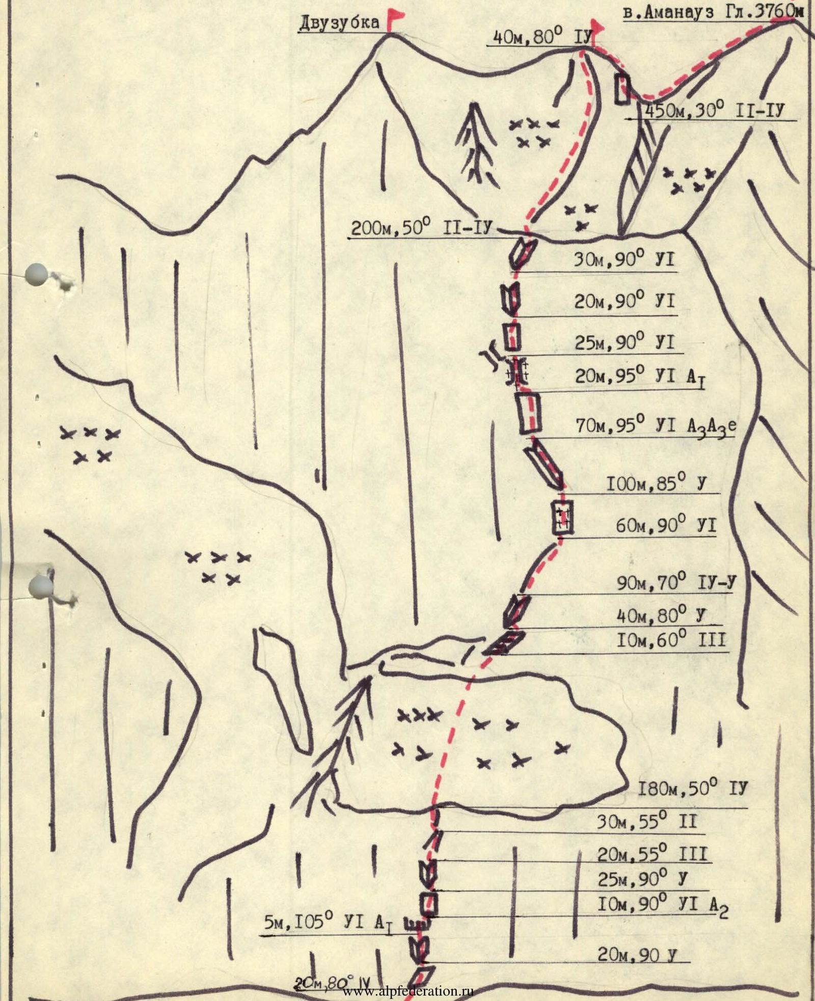
ASCENT ROUTE TO MT. AMANAUZ MAIN VIA THE NORTHEAST WALL, CATEGORY 5B DIFFICULTY.
Route Sections (according to the diagram):
- Dvuzyubka
- Mt. Amanauz (Main) 3760 m
- 40 m, 80° 4
- 450 m, 30° 2–4
- 200 m, 50° 2–4
- 30 m, 90° 6
- 20 m, 90° 6
- 25 m, 90° 6
- 20 m, 95° 6AT
- 70 m, 95° 6A3e
- 100 m, 85° 5
- 60 m, 90° 6
- 90 m, 70° 4–5
- 40 m, 80° 5
- 10 m, 60° 3
- 180 m, 50° 4
- 30 m, 55° 2
- 20 m, 55° 3
- 25 m, 90° 5
- 10 m, 90° 6A2
- 5 m, 105° 6AT
- 20 m, 90° 5

The photo was taken at the end of August this year.