- Climbing type: rock climbing
- Climbing area: Western Caucasus
- Summit: Amanauz Main, 3757 m via 2-3 wall.
- Route difficulty category: 5B category
- Height difference: 880 m
- Length of sections with IV–VI category difficulty — 450 m Total route length: 1030 m. Average steepness: 60°
- Pitons hammered in: rock pitons — 68, bolt pitons — 0, use of placed elements — 52
- Number of travel hours: 26 hours
- Overnight stays: one shared bivouac
- Team members: Gatanov Sergey Borisovich — CMS, team leader Karzanov Alexander Viktorovich — CMS Pirogov Alexey Vladimirovich — CMS Pogodin Boris Sergeevich — CMS
- Team coach: Master of Sports of the USSR Magomedov Kh.K. II. 30.07 — Dombay tourist base — Verkhne-Sofrujinsky bivouac 31.07 — Verkhne-Sofrujinsky bivouac — bivouac under the route 01.08 — bivouac under the route — bivouac under the 2nd bastion 02.08 — bivouac under the 2nd bastion — summit — bivouac on descent 03.08 — bivouac on descent — Dombay tourist base
- Climbing organized by Dombay tourist base.
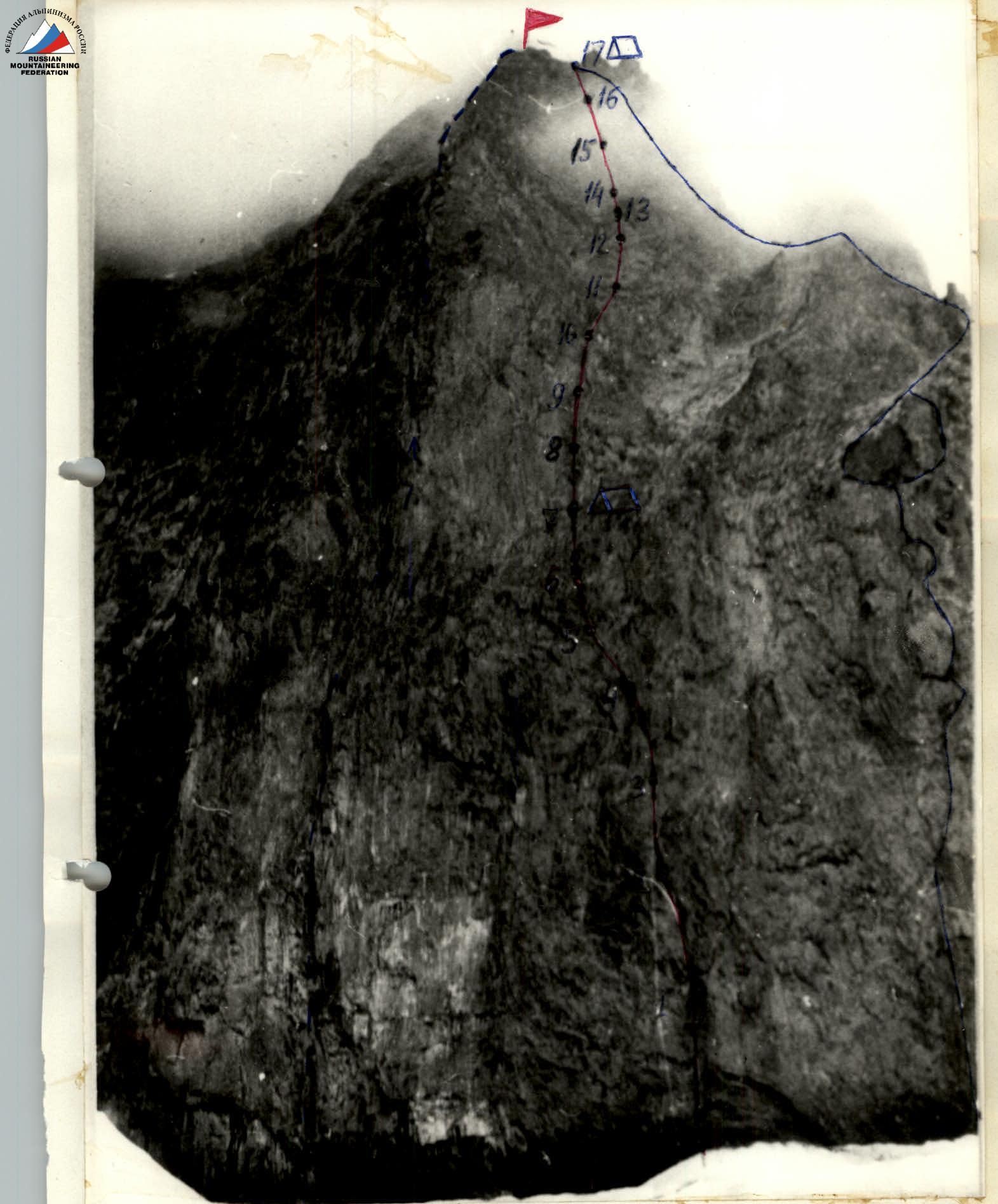
Southwest wall of Amanauz Main
- route taken by the group
- route on the South wall 5B category
- route on the West counterfort 5B category
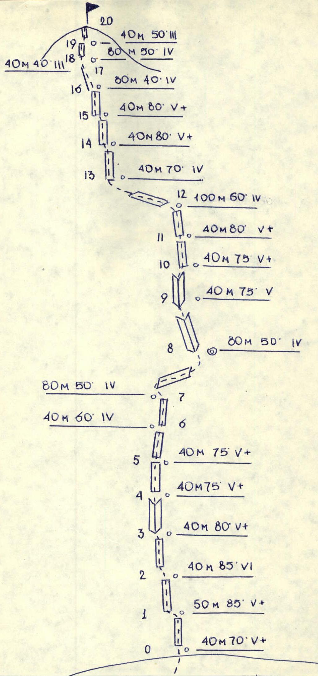
Table of sections for the ascent route to Amanauz Main via the 2-3 wall
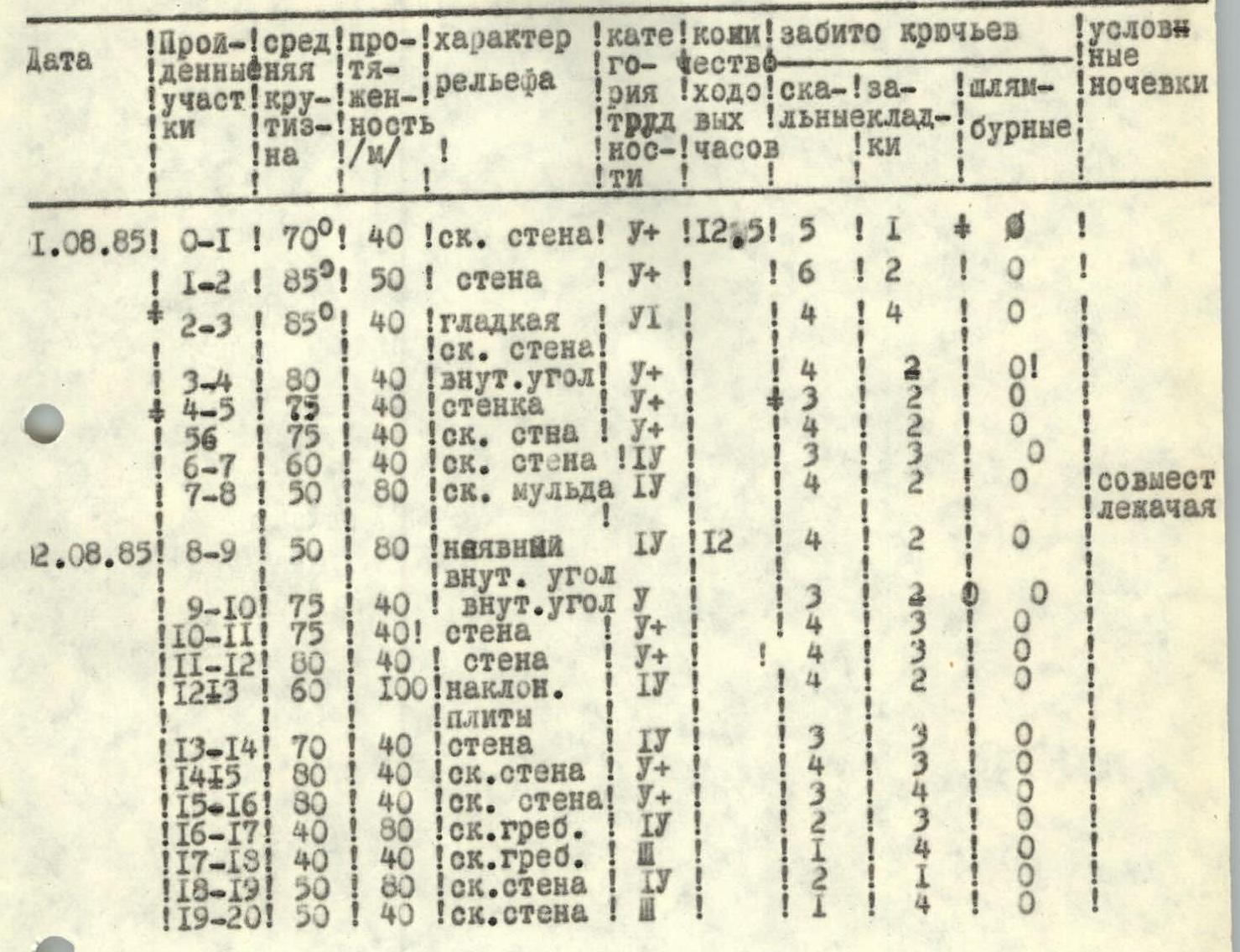
| Date | Section | Steepness | Length, m | Terrain characteristics | Difficulty category | Travel hours | Rock pitons | Placed pitons | Bolt pitons | Overnight stays |
|---|---|---|---|---|---|---|---|---|---|---|
| 01.08.85 | R0–R1 | 70° | 40 | rock wall | V+ | 12:05 | 5 | 1 | 0 | |
| 01.08.85 | R1–R2 | 85° | 50 | wall | V+ | 16 | 2 | 0 | ||
| 01.08.85 | R2–R3 | 85° | 40 | smooth rock wall | VI | 4 | 4 | 0 | ||
| 01.08.85 | R3–R4 | 80° | 40 | inner corner | V+ | 4 | 2 | 0 | ||
| 01.08.85 | R4–R5 | 75° | 40 | small wall | V+ | 3 | 2 | 0 | ||
| 01.08.85 | R5–R6 | 75° | 40 | rock wall | V+ | 4 | 2 | 0 | ||
| 01.08.85 | R6–R7 | 60° | 40 | rock wall | IV | 3 | 2 | 0 | ||
| 01.08.85 | R7–R8 | 50° | 80 | rock depression | IV | 4 | 2 | 0 | ||
| 02.08.85 | R8–R9 | 50° | 80 | overhanging inner corner | IV | 12 | 4 | 2 | 0 | shared bivouac |
| 02.08.85 | R9–R10 | 75° | 40 | inner corner | V | 3 | 2 | 0 | ||
| 02.08.85 | R10–R11 | 75° | 40 | wall | V+ | 4 | 3 | 0 | ||
| 02.08.85 | R11–R12 | 80° | 40 | wall | V+ | 4 | 3 | 0 | ||
| 02.08.85 | R12–R13 | 60° | 100 | inclined slabs | IV | 4 | 2 | 0 | ||
| 02.08.85 | R13–R14 | 70° | 40 | wall | IV | 3 | 3 | 0 | ||
| 02.08.85 | R14–R15 | 80° | 40 | rock wall | V+ | 4 | 3 | 0 | ||
| 02.08.85 | R15–R16 | 80° | 40 | rock wall | V+ | 3 | 4 | 0 | ||
| 02.08.85 | R16–R17 | 40° | 80 | rock ridge | IV | 2 | 3 | 0 | ||
| 02.08.85 | R17–R18 | 40° | 40 | rock ridge | IV | 1 | 1 | 0 | ||
| 02.08.85 | R18–R19 | 50° | 80 | rock wall | IV | 2 | 1 | 0 | ||
| 02.08.85 | R19–R20 | 50° | 40 | rock wall | V | 1 | 4 | 0 |
Total: IV–VI category — 450 m. Total route length: 1030 m. The entire route is free climbing.
Brief explanation of the table
From Dombay clearing via the Amanauz gorge trail to the stream descending from the large Belalakay couloir. Across the stream to the snowfield and 300 m up, then left into the Sofrujinsky couloir (rockfall hazard). 100 m along the couloir, then right onto the ridge and along the trail to the Nizhne-Sofrujinsky bivouac (2–3 hours). Then up along the trail, then across the snowfield left of the eastern slopes of Belalakaya, exit to the Verkhne-Sofrujinsky bivouac (2 hours). From Verkhne-Sofrujinsky bivouac to Sofrujinsky summit (3 hours). Descent to Amanauz pass takes 30 minutes. (Approach from below to Amanauz pass is hazardous at this time due to ice falls). Descent from Amanauz pass onto the glacier along the left part of the "ram's foreheads", in the lower part descent via glaciers (rockfall hazard). To the moraine bivouac — 4 hours. From the bivouac, approach to the start of the route takes 1.5 hours.
Start of the route — left from the characteristic arched corniche. The route begins along a steep smooth slab.
Sections R0–R3:
- Climbing is very difficult, sometimes problematic.
- Few places for piton placement.
Sections R3–R4:
- Rock is partly overhanging with smooth walls.
Sections R4–R6:
- Smooth steep walls.
- Minimal terrain features.
Sections R6–R9:
- Depression.
- Difficult to organize belay.
- There is a platform for a tent at the top.
- At the top, entrance to a wide chimney.
Sections R9–R10:
- Depression.
- Difficult to organize belay.
- There is a platform for a tent at the top.
- At the top, entrance to a wide chimney.
Sections R9–R10:
- Rock goes up and left.
- Walls are smooth.
- Difficult climbing.
Sections R10–R12: Up steep and very broken rock. (Climbing on loose rocks! Caution!)
Sections R12–R14: Slabs covered with moss. "Live" rocks present. Be very careful.
Sections R14–R15: Steep walls, smooth.
Sections R15–R16: Series of walls with cornices, "live" rocks. Be very careful.
Sections R16–R18: Rock ridge.
Sections R18–R19: Slabs.
Sections R19–R20: Wide couloir, "live" rocks.
Descent via 3B category route.
On the route, few places for piton placement. Used:
- Horizontal pitons 3–5 mm
- Boxes
- Chocks