Alibekskiy Peak
Ascent Passport
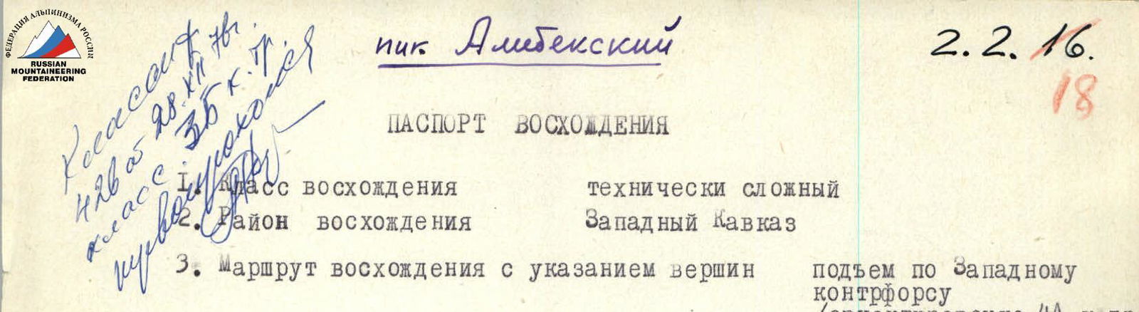
- Ascent route with indication of peaks: ascent via Western counterfort (approximately 4A category of difficulty)
- Ascent characteristics: height difference 750–800 m, average steepness 55–60°
- Pitons hammered in: rock — 22 pcs. ice — none bolt — none
- Number of climbing hours: 12–13
- Number of nights and their characteristics: overnight stay near the control cairn meets safety and comfort conditions.
- Team name: team of a/l "ALIBEK"
- Surname, name, patronymic of the leader, participants, and their qualification: TARASENKO V.V. — 1st sports category, leader PRIMA Yu.V. — Candidate for Master of Sports, participant KHAMTSOV A.P. — 1st sports category, participant ABUKOV A.Kh. — 2nd sports category, participant
- Team coach: Master of Sports of the USSR PULINETS Yu.S.
- Dates of departure and return: July 21–22, 1975
Route Description
From Dzerzhynets Peak, located in the Main Caucasian Range, a mountain range extends north with peaks Aap Peak and Alibekskiy Peak. Alibekskiy Peak is located north of Dzerzhynets Peak and south of Aap Peak.
Peaks forming the cirque where the Alibek glacier is located:
- Aap Peak
- Alibekskiy Peak
- Dzerzhynets Peak
- Alibek-Bashi
- Ertzog
- Razdelny Peak
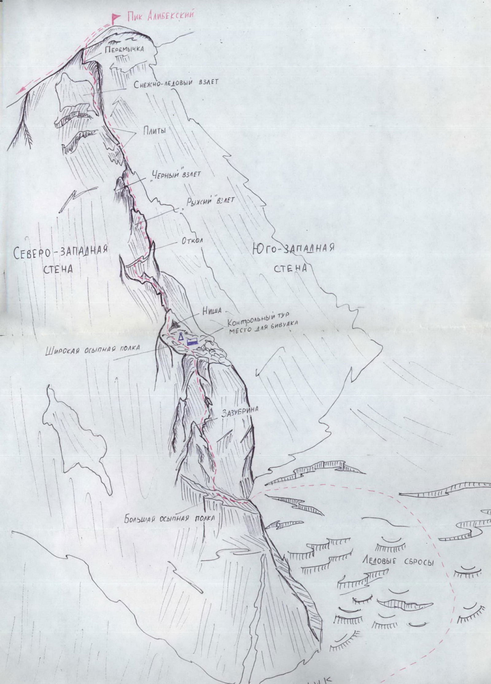
The route to the summit of Alibekskiy Peak goes via the Western counterfort and is of a rocky nature, except for the approach, which passes through the glacier.
From a/l "ALIBEK" follow the trail to Alibek hut. From the hut, traverse the Alibek glacier to approach the Western counterfort. The route begins from the second talus shelf on the right part of the counterfort.
In the second half of summer, the glacier is heavily crevassed; travel in rope teams is necessary. From the hut to the start of the route on the right part of the counterfort takes 3–4 hours.
Exit from the snow onto the talus shelf via slabs with piton belay. Traverse the shelf for 80 m to exit onto the left part of the counterfort. Then, ascend rocks of medium difficulty straight up to a notch. From the notch, go straight up for 40 m (piton belay).
Continue via slabs to beneath an inclined inner corner. Traverse slabs and the inclined inner corner to reach a 40 m wide shelf. Piton belay. From the shelf, ascend rocks of medium difficulty to reach a wide talus shelf. Control cairn and bivouac site.
From the control cairn, go left of the niche into a wide inner corner. Then, move right onto a sharp ridge and follow it to beneath the base of the rusty ascent.
At the base of the rusty ascent, transition to its right part and climb straight up for 40 m with difficult climbing. Piton belay! Continue along the ridge to beneath the second black ascent, consisting of rock "feathers". Bypass the second ascent on the right to reach the ridge. Continue up smooth slabs (steepness 30°) for 150 m (piton belay). Early in the summer, the slabs may be ice-covered. Then, ascend rocks to beneath a steep snow-ice ascent. Continue up steep, smooth rocks to the right and then left and up for 40 m to reach a saddle (piton belay). From the saddle, ascend rocks of medium difficulty to reach a snow-ice ridge leading to the summit. Time from the glacier to the summit is 8–9 hours.
Descend from the summit along the ridge to Aap Peak. From Aap Peak, descend via a route of 1st category of difficulty.
Initially, the group assessed the route as 3B category of difficulty. However, after completing the route, the group concluded that the route is more challenging than 3B and can be classified as 4A category of difficulty.