Ascent Passport. I. Rock climbing category. 2. Dombay region, North-West Caucasus. 3. Ascent to Avstriyskiy Komsomola peak (3654 m) via left NE edge — first ascent. 4. Difficulty category — 4B. 5. Route characteristics — rock climbing. Height difference 1050 m, length 1350 m, length of sections with IV difficulty category — 950 m, average steepness 60°. 6. Diverse insurance: 30 rock pitons were hammered for insurance, rope loops were used 25 times. 7. Departure and return dates to the camp: 5–7 August 1976. 8. Number of travel hours from the start of the route to the summit — 12 hours and descent to Belalakaya glacier another 5.5 hours. The ascent was made on August 6, 1976 (The group had a reserve of warm clothing, a primus stove, etc.). 9. Sports group: Starikov G.A. — 1st sports category, instructor Stepanov E.L. — with observers on the glacier — 3rd category climbers. 10. Training part of "Dombay" alpine camp.
Map-scheme of the region.
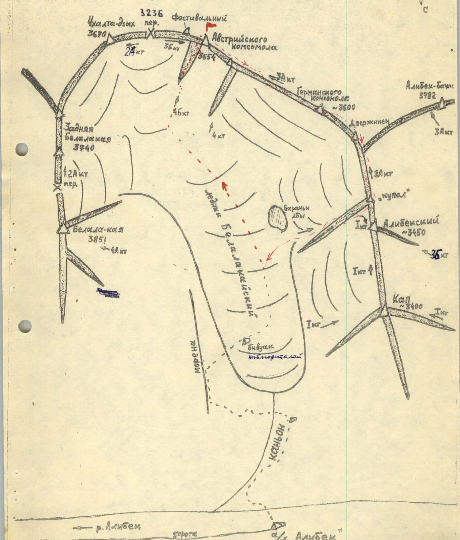 Approach to the route.
From Alibek alpine camp along the trail and waterfalls of Belalakay canyon — 0.5 hours. Along the steep trail on the right side of the canyon, ascent (in the upper part of the path through gentle rocks) to the large bivouac sites — another 1 hour. From here, the tongue of Belalakay glacier and the left lateral moraine are visible, which will be used to ascend to the glacier.
Approach to the route.
From Alibek alpine camp along the trail and waterfalls of Belalakay canyon — 0.5 hours. Along the steep trail on the right side of the canyon, ascent (in the upper part of the path through gentle rocks) to the large bivouac sites — another 1 hour. From here, the tongue of Belalakay glacier and the left lateral moraine are visible, which will be used to ascend to the glacier.
It is necessary to cross the stream to the left:
— via a snow bridge — or if it is unreliable or absent — climb over a large boulder-choke located slightly downstream of the stream.
Then, along a grassy trail, ascend to the moraine and along its ridge reach the glacier — another 1 hour. Here, on the medial moraine, it is most convenient to set up an overnight stay, as the beginning and the entire route of the upcoming ascent are clearly visible from here (photo 1).
Description of the ascent (brief explanation to table 1)
From the overnight stay, the path goes along the middle or right (in the direction of travel) side of the glacier (closed crevasses) in a rope team with caution against falling into hidden crevasses to the place where the left NE edge of Avstriyskiy Komsomola peak descends — 1.5 hours.
R0–R1: Along the snowfield to the right along the beginning of the edge upwards, then traverse left to the narrowest part of the randkluft, which is crossed with an ascent to the edge's shoulder. Here, a large cairn is built, but without a note — the immediate start of the route. Changed into galoshes.
R1–R2: Initially, the route passes along the right part of the ridge, rocks are monolithic with separate lying boulders; further along the edge's ascent, having the same character of rocks. At the end of the section, 30 m beyond the ascent, a control cairn with a note is built.
R2–R3: Upwards along the edge to the "ledge with flowers", as everywhere: insurance is alternating, using pitons and loops on ledges.
R3–R4: Upwards 80 m under the "triangle", which is bypassed to the right along a 20 m inner corner, another 40 m upwards-left — exit to the "shoulder". From here, two pinnacles are visible directly above, to the left of the summit.
R4–R5: Further upwards is a wall of blue rocks. It seemed complicated to go straight on, although it is logical. From the "shoulder" 45 m straight up, then a careful traverse along narrow ledges 2.5 ropes to the right above the sheer face (psychologically challenging spot!) to a site under black rocks. This is a place where a bivouac is possible, as there is water and a convenient 1.5 m wide ledge for the first time on the route.
R5–R6: From the site, returning 15 m, through a 2-meter wall, enter a difficult and wet inner corner — 40 m along it left-upwards to a ledge, from which another 40 m to the exit to a wide main ledge.
R6–R7: — traverse along ledges to the left is not complicated (60 m) — through blocky rocks, ascent to the saddle of the East ridge.
R7–R8: — along a very steep ascent of the ridge (in the lower part almost sheer) three ropes with careful insurance — then along the ridge simultaneously to the summit cairn.
From the summit of Avstriyskiy Komsomola, there are three options for descent to Belalakaya glacier:
- Along the East ridge to Chkhalta-dzykh pass, 3B difficulty category.
- Along the South ridge, traverse left through the green counterfort and ascent to Chkhalta-denkh pass, approximately 3 km difficulty category.
- Traverse to German Komsomola peak and further along the ridge towards Kap peak, with descent to the glacier, 3A difficulty category. Path (3) was familiar to G. Starikov, who passed it a week earlier, so the group used this path, spending 5.5 travel hours to the observers on the glacier.
Route features: — dry, rocky, very steep — climbing in galoshes is necessary for all participants for confident passage of complex sections — insurance through pitons and loop-ledges is multiple.
It should be taken into account that the first ascent was made by a "duo". Possible overnight stay locations at points R5, R7, see photos 2, 3.
Conclusion on the route.
Group member E. Stepanov, who had previously climbed a 5A difficulty category route on West Dombay from a pass, evaluates the first ascent as steep, tense, somewhat more complicated than Dombay. Overall, the group evaluates the route as 4B difficulty category based on technical complexity, height difference, and length; comparable to Main Amanauz by South wall (counterfort) 4B difficulty category, West Dombay from the pass 5A difficulty category, more complicated than Komosomola peak by East wall 4A (4B), West Dombay by the 3rd ridge (Sasorova) 4B difficulty category, and others.
Equipment for a duo.
| Item | Quantity |
|---|---|
| Main rope (12 mm) 40 m | 1 |
| Repschnur 40 m | 1 |
| Ice axe and ice hammer | 2 |
| Rock hammer | 1 |
| Pitons | 15 |
| Ice screws (VTsSPS) | 2 |
| Zdarka tent | 1 |
| Febus primus stove | 1 |
| Gasoline 1 l | |
| Down jackets and pants | 2 sets |
| Galoshes | 2 pairs |
| Vitalka radio | 1 |
| First aid kit | not used |
| Electric flashlight | not used |
| Loops made from main rope | 4 pcs. |
| Chocks | 2 pcs. |
Table 1. Route description.
| Date | Section | Steepness | Length, m | Terrain characteristics | Time, h | Section difficulty category | Weather conditions | Rock pitons | Other insurance equipment |
|---|---|---|---|---|---|---|---|---|---|
| 5 August 1976 | Approach and route observation | 3.5 | along trail, moraine | ||||||
| 6 August 1976 | Glacier with closed crevasses | 1.5 | firn | ||||||
| 6 August 1976 | R0–R1 | up to 30° | 200 | snow slope with bergschrund | 1.0 | 1 | firn | insurance via ice axe | |
| 6 August 1976 | R1–R2 | 60° | 360 | rocky edge | 2.5 | 4 | monolith | 7 | |
| 6 August 1976 | R2–R3 | 60° | 240 | rocky edge to ledge | 1.5 | 4 | — | 3 | |
| 6 August 1976 | R3–R4 | 60° | 120 | rocky wall to shoulder | 1.0 | 2 | — | 5 | |
| 6 August 1976 | R4–R5 | 60° | 140 | rocky wall, traverse around | 2.0 | 4 | unstable sections | 6 | |
| 6 August 1976 | R5–R6 | 90–80° | 80 | rocky inner corner wet | 1.0 | 4 | solid | 5 | |
| 6 August 1976 | R6–R7 | 20–55° | 55 | rocky ledge left-upwards | 0.5 | 2 | solid | 2 | |
| 6 August 1976 | R7–R8 | 45° | 160 | rocky ridge-ascent to summit | 1.0 | 3 | monolith | 2 | |
| 6 August 1976 | Total | 60° | 1355 | NE rocky edge left | 12 | 4Б | monolith | 30 | 25 loops |
| 7 August 1976 | On descent — see description | 5.5 | 3 | 4 loops via ice axe | |||||
| 7 August 1976 | Return to "Dombay" alpine camp | 3.0 | — |